Image

Chamberlain and the Salute of Arms

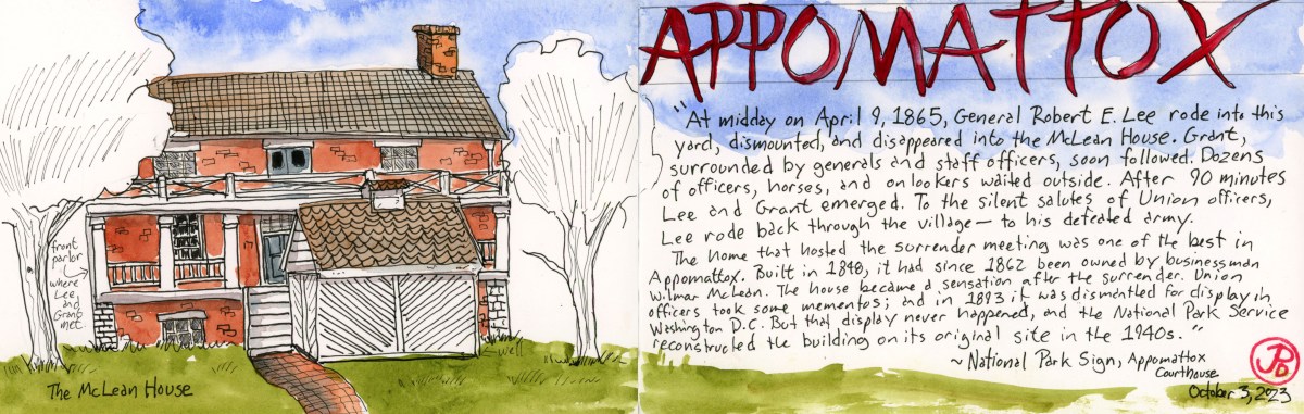
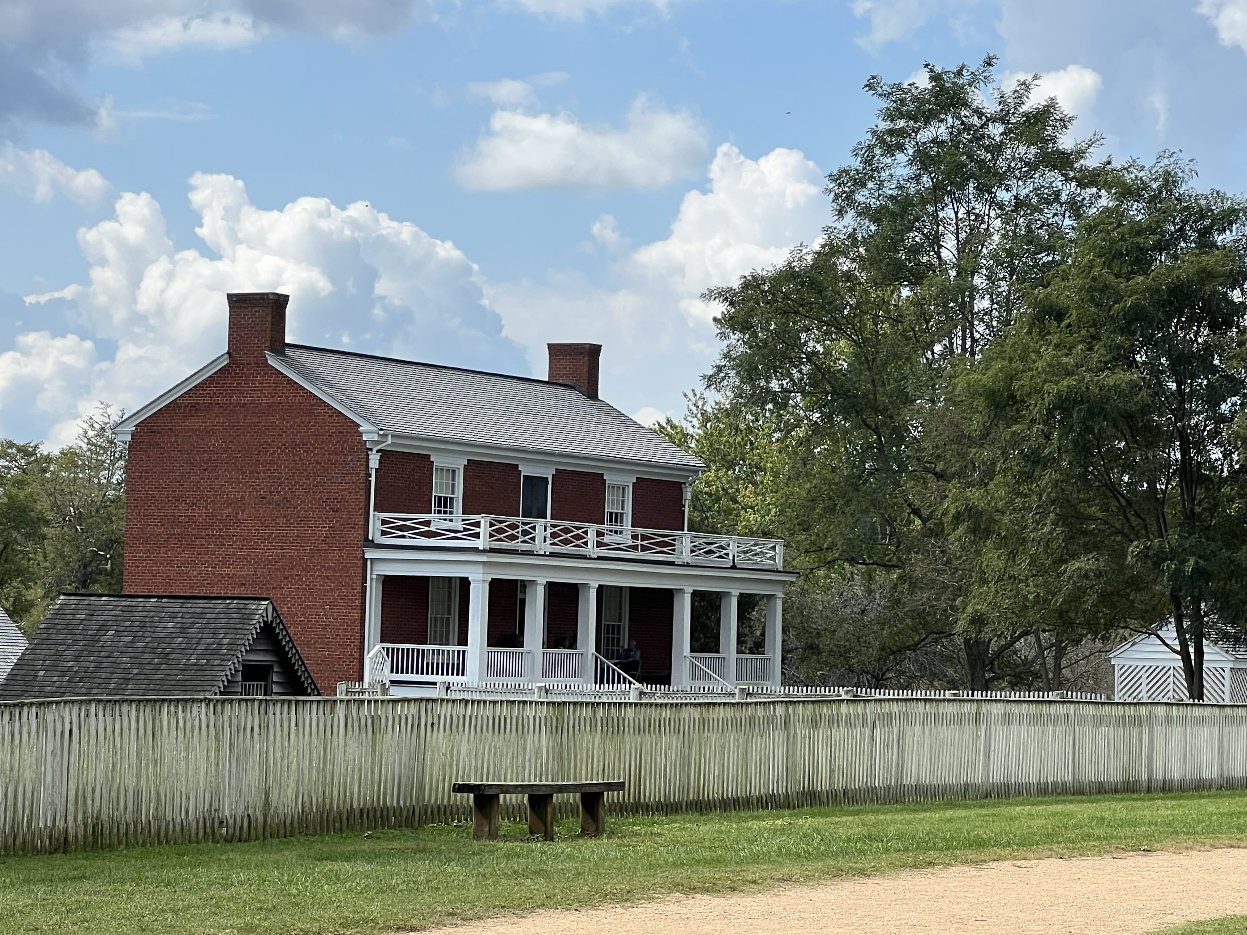
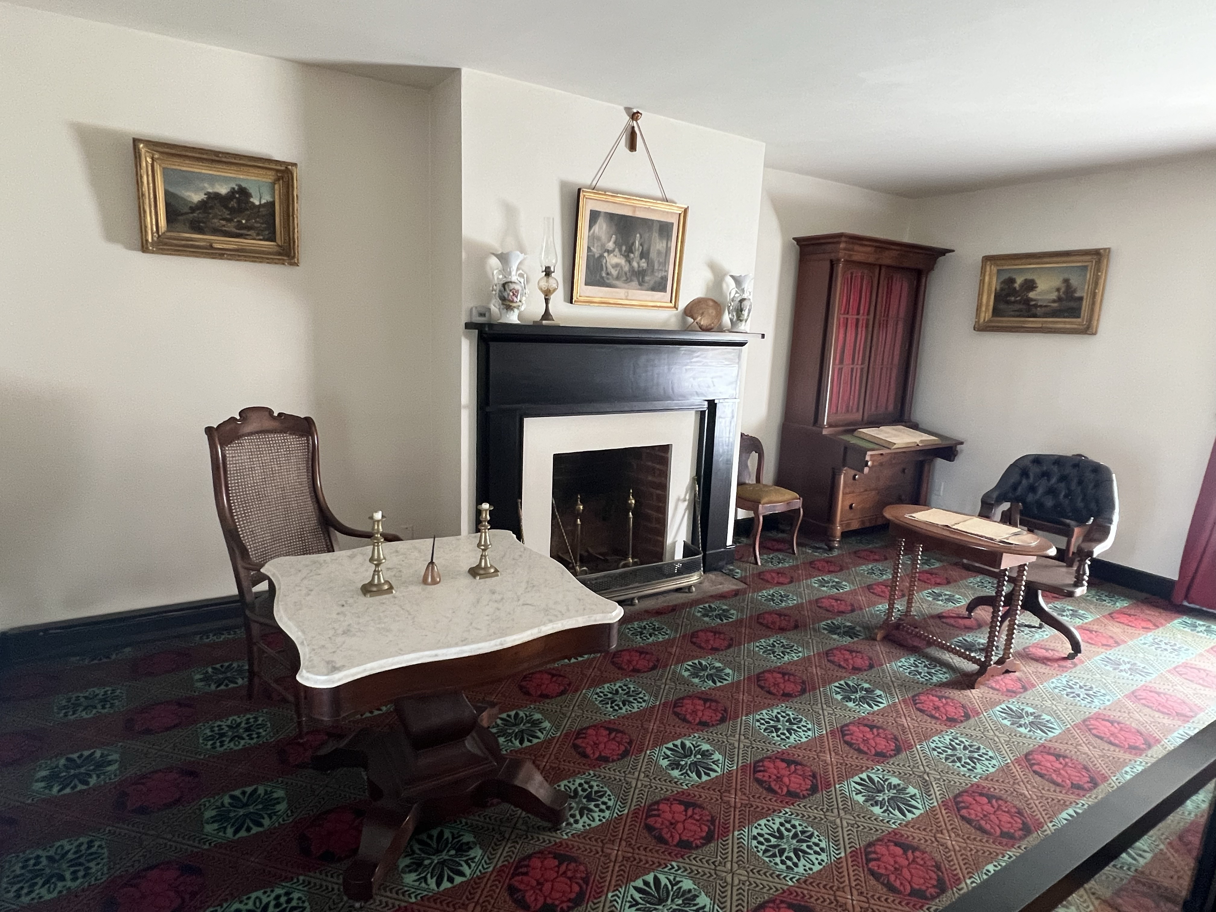
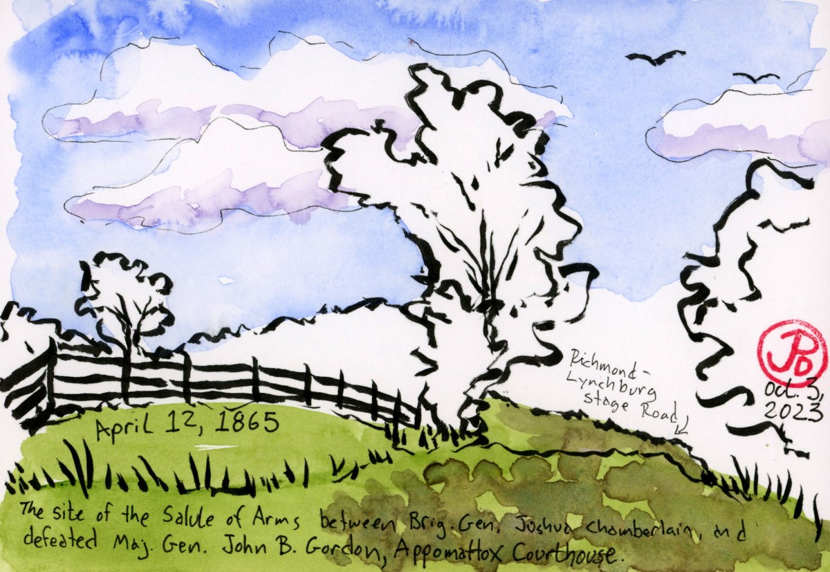
One of the most touching passages of the Civil War happen on April 12, 1865 as Robert E. Lee’s Army of Northern Virginia surrendered at Appomattox Courthouse.

The setting was northeast of the courthouse and just past the Peers House on the Richmond-Lynchburg Stage Road. This was the offical surrender ceremony a few days after Lee had surrendered to General Ulysses S. Grant at the McLean House.

The event is best related in a passage from James McPherson’s Pulitzer Prize winning history of the Civil War, Battle Cry of Freedom:

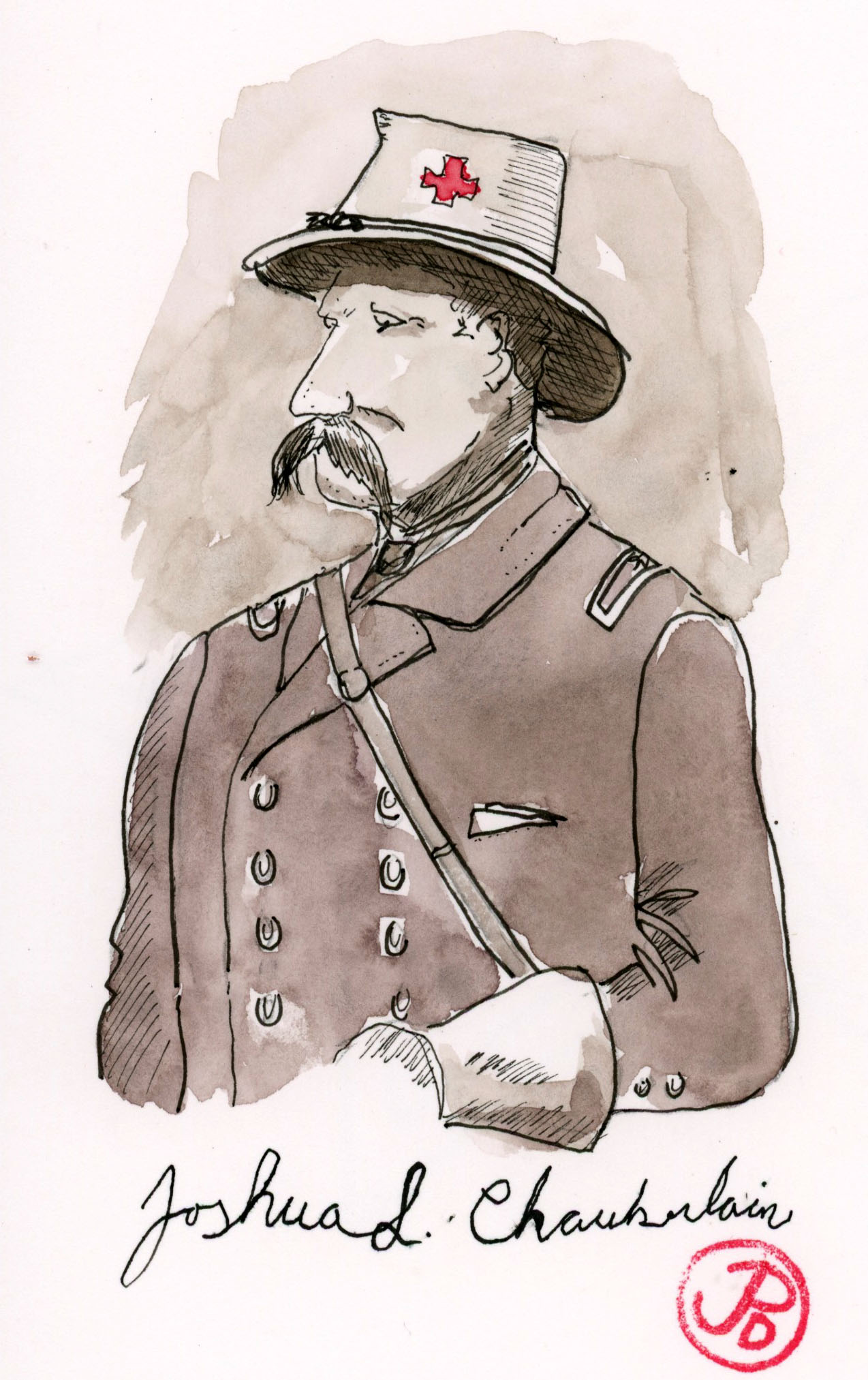
The Union officer in charge of the surrender ceremony was Joshua L. Chamberlin, the fighting professor from Bowdoin who won the medal of honor for Little Round Top, had been twice wounded since then, and was now a major general. Leading the southerners as they marched towards two of Chamberlain’s brigades standing at attention was John B. Gordon, one of Lee’s hardest fighters who now commanded Stonewall Jackson’s old corps. First in the line of march behind him was the Stonewall Brigade, five regiments containing 210 ragged survivors of four years of war. As Gordon approached at the head of these men with “his chin drooped to his breast, downhearted and dejected in appearance,” Chamberlain gave a brief order, a bugle call rang out. Instantly the Union soldiers shifted from order arms to carry arms, the salute of honor. Hearing the sound General Gordon looked up in surprise, and with sudden realization turned smartly to Chamberlain, dipped his sword in salute, and ordered his own men to carry arms. These enemies in many a bloody battle ended the war not with shame on one side and exultation on the other but with a soldier’s “mutual salutation and farewell.”

This interaction between the victorious north and the defeated south was the first step in helping to bring a divided and bloodied nation back on the path to becoming the United States again. Did it work? I leave it to you, dear reader, to decide.

The Peers House at Appomattox Courthouse. The site of the Chamberlain-Gordon encounter is just down the stage road to the left of the Peers House.

On the morning of April 9, 1865, the Army of Northern Virginia was involved in it’s final wartime conflict. The last shots where fired from the front yard of the Peers House. The cannon shot caused some of the last casualties of the war in Virginia.

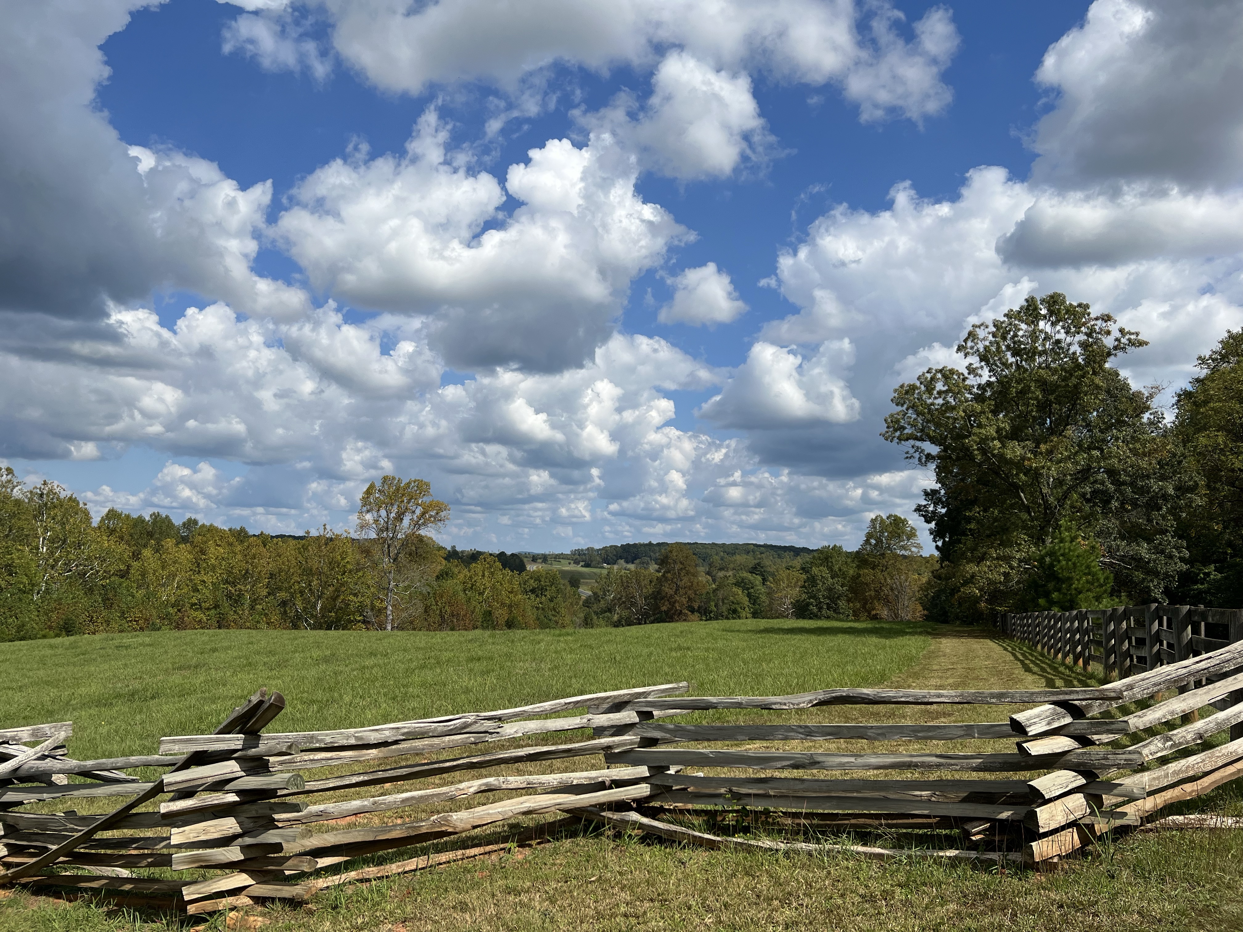
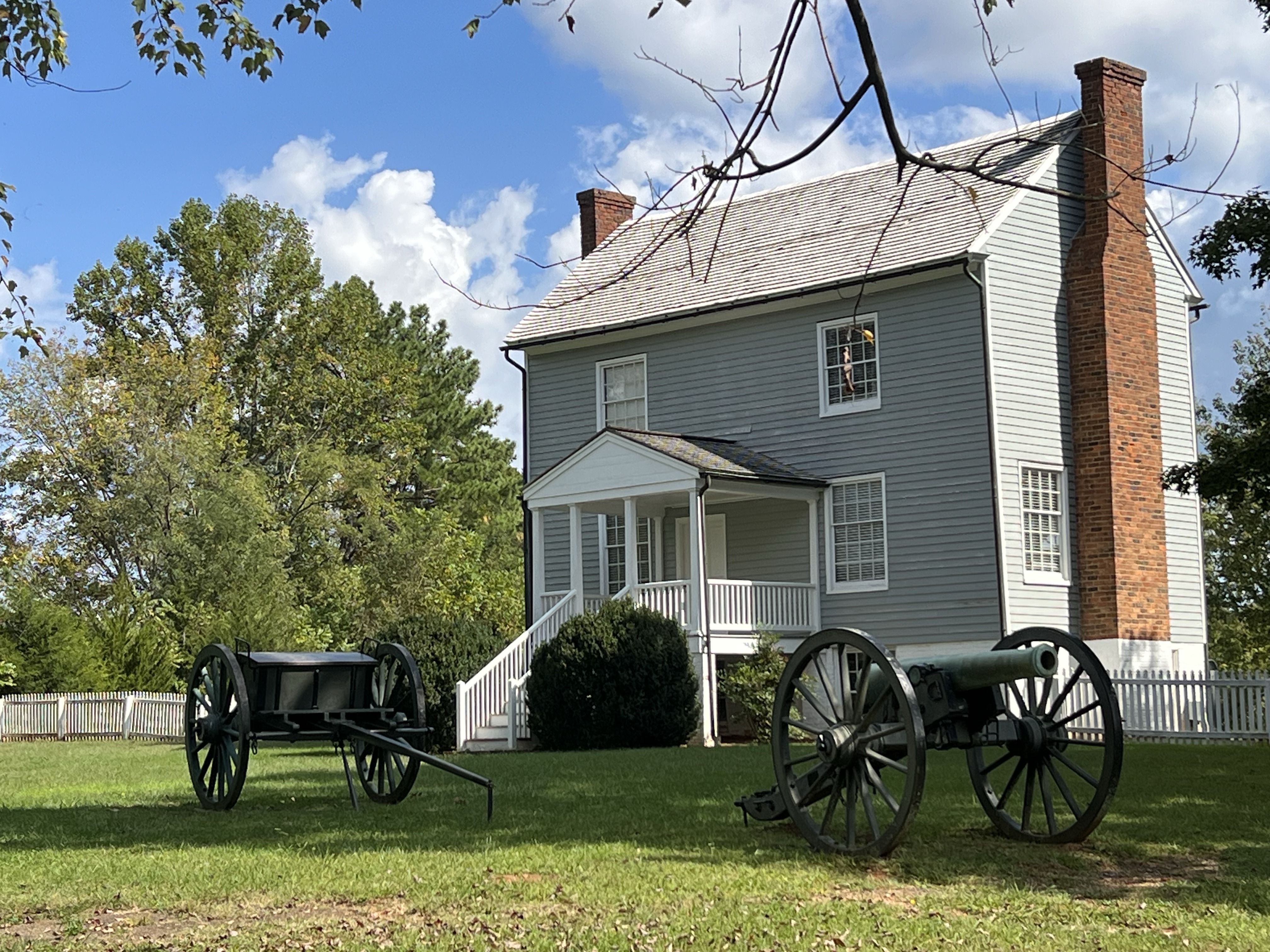
The countryside around Appomattox Courthouse is beautiful. The photo above is taken near the spot of Lee and Grant’s second meeting. The meeting occurred on the morning of April 10 with both men on horseback. While the surrender in McLean’s front parlor pertained to the Army of Northern Virginia, Grant tried to persuade Lee to convince the remaining Confederate forces to surrender. Lee refused telling Grant that the decision was up to the President of the Confederacy, Jefferson Davis.

To the right of this photo and out of frame is the location of Chamberlain’s Salute of Honor. I sketched the view looking down the Richmond-Lynchburg State Road (featured sketch).

Image

Signs of Williamsburg

I headed into Colonial Williamsburg early in the morning to beat the crowds and to get some sketching in.

When you are in Williamsburg early in the morning you beat the crowds but service vans replace horse-drawn carriages. Colonial Williamsburg seems less “Colonial”.

I loved the signs of Colonial Williamsburg. On an early morning ramble on a side street I came upon the Sign of the Rhinoceros, an apothecary. So I sketched the whimsical sign into my sketchbook (featured sketch).

These signs are visual and told anyone who was illiterate what was to be found inside. Not everyone could read in pre-revolutionary Virginia.

A golden ball was the calling card of a watchmaker.
I’m not sure what is sold here but I bet it’s not bells.
If you couldn’t read the words below, the image above tells you exactly what you can procure in this shop.
Image

Southern Pacific Cab Forward No. 4294

The last steam locomotive that Southern Pacific ever purchased is on display at the California State Railroad Museum in Sacramento. And she’s massive!

This is the only one of the 256 cab-forwards that still exist. The 4-8-8-2 locomotive was turned around so the cab was in front and the exhaust was behind the cab and crew. The natural habitat of the AC-12 Class No. 4294 was over Donner Summit. And because of the heavy snowfall in the Sierra Nevada Mountains, 37 miles of the line was covered in snow sheds to keep snow off the tracks. This innovative design prevented the crew from smoke exhaust induced asphyxiation.

This last of the cab-forwards was such an engineering marvel that it was designated a National Historic Mechanical Engineering Landmark by the American Society of Mechanical Engineers in 1981. It was the first steam locomotive to be added to the list. Of the 300 landmarks in existence, only seven are steam locomotives, including Union Pacific’s Big Boy No. 4023 and Norfolk and Western J-Class No. 611 (more about 611 in a later post).

This locomotive is massive and the largest and most powerful locomotive in the museum’s collection. The locomotive and tender are 123 feet and 8 inches long and the total weight of this Beast of the Sierras is 1,051,200 pounds (525 tons). One of the docents I talked to was old enough to see a cab-forward in action as a child and he told me that the locomotive scared him and the ground shook when it passed by.

On my visit to the California State Railroad Museum, high on my sketching list was this massive cab-forward. There was only so many perspective to sketch 4294, I tried sketching from above but I couldn’t see the entire locomotive and tender from the third floor gallery so I took a seat under the massive glass Southern Pacific logo and sketched 4294’s front and left side. My wide panoramic journal was perfect for this.

Drawing the complicated running gear was a challenge so I used along of shorthand and used my sketcher’s license!
Looking down the length of 4294 to where I sketched this Beast of the Sierras. I sat on the bench under the SP logo that was once at the Port of Oakland.
Image

Appomattox Courthouse

One Civil War location I have been interested in visiting and sketching for a long time is Appomattox Courthouse in southern Virginia.

This is not the site of a major battle. Civil War lovers come here to visit a house just down the street from the courthouse and pay a visit to the front parlor.

Now how did this small parlor in a small southern Virginia town become a major historical landmark?

This is where the Civil War ended, at least on paper.

The McLean House.

The Confederate Army of Northern Virginia, commanded by General Robert E. Lee, was surrounded by Union forces near the small town of Appomattox Courthouse. Lee was now out of options and had no choice but to surrender. Lee said, “there is nothing left for me to do but go and see General Grant, and I would rather die a thousand deaths. “

On April 9, 1865, in the early afternoon, Robert E. Lee, entered the village of Appomattox Courthouse. He headed past the courthouse and stopped at the McLean House. Lee dismounted his horse Traveller, and entered the house.

Shortly afterwards General Ulysses S. Grant, General-in-Chief of all the forces of the United States, entered the house.

The front parlor where Lee surrendered to Grant.

The two men met in Wilmer McLean’s front parlor while the family was in the upstairs bedrooms. Here the lenient terms of surrender where agreed upon. The Confederate soldiers had to pledge not to take up arms again against the United States, they had to turn in their rifles but could keep their sidearms, and Lee was allowed to go free.

This surrender Appomattox was the beginning of the process of reunification.

Or was it?

Coda: Before he lived in Appomattox Courthouse, Wilmer McLean lived further north in Manassas.

During the the first battle of Manassas (aka Bull Run), McLean’s house was used by Confederate General Beauregard as his headquarters. His house was shelled by Unionist cannons.

It is said of McLean that the Civil War, “began in his front yard and ended in his front parlor”.

Image

Airport Sketching: SFO to DCA

Having made it through TSA in 11 minutes on a Saturday morning, I found myself before Gate D9, an hour and a half before boarding. Being that I was in the back of the plane, in Boarded Group F (I’ll let you use your imagination as to what F stands for), I knew that I would be one of the last to board the Alaska Boeing 737.

So after getting some joe and a scone, I found an empty row and had breakfast.

Now it was time to get low tech in the form of my soft cover Stillman and Birn Beta Series sketchbook (No batteries required).

I found one of those nice swivel chairs and sketched the Alaska Airlines jet at gate D9. The Boeing 737 sat at the gate with a fuel hose attached to the bottom (always a good sign) and the crew loading luggage into it’s underbelly.

Our flight was on time and despite the demands to check bags from Boarding Groups E and F because the overhead bins were full.

I was able to waltz on the plane as a one bag backpacker, shouldering my Osprey Farpoint 40 and I found an empty bin right above my aisle seat in Rom 30 (at least I was close to the bathrooms!).

On the other half of my panoramic sketch I added my view from Row 30, Seat D.

A little time travel: the featured sketch is from Reagan National Airport (DCA), in Virginia, just across the Potomac from Washington D. C. This panoramic sketch is from my return journey to SFO.

Image

Colonial Williamsburg

Colonial Williamsburg is a sketcher’s paradise, especially if you love to sketch architecture.

Williamsburg was the capital of Virginia, preceded by the first permanent English settlement at Jamestown and followed by Richmond (which moved from Williamsburg at the time of the Revolutionary War to be further away from the coast). The capital of Virginia remains in Richmond today.

Colonial Williamsburg represents the capital in the years leading up to the break with Britain. It is billed as the “world’s largest U. S. history museum.”

Many of the current buildings have been restored or even reconstructed to appear as they did in the years before the American Revolution.

Along Williamsburg’s streets are historical reenactors who portray people of the time. Which reminds me of California’s Renaissance Pleasure Faire (a reenactment of Elizabethan England).

You can enter many of the buildings and are met by period interpreters who talk about the life and times of the people of Williamsburg.

One of these building I toured was the home of Peyton Randolph (featured sketch), one of the Founding Fathers of the United States. He was the first president of the First Continental Congress. Randolph was a very wealthy and influential man. He died in 1775, a year before America’s monumental year. Some historians have theorized that, had he lived, he would have been our Nation’s first president.

It took 27 slaves to tend to the house and part of the tour focused on the slave quarters.

In most cases, slaves slept where they worked. So if you were a cook, you slept in the kitchen. If you where a personal servant to the lord of the house, you slept on a straw stuffed mattress which resembles a large dog bed placed at the foot or the side of their master’s bed.

Another building that I toured and sketched was the Capitol Building. It was in this two chambered government building that representatives from the colonies meet with the British government sowing the seeds of our own independence.

The clock tower of the Capital building. I couldn’t fit the tower into my sketch and it was also shrouded in trees, and I ran out of paper!
Image

Yorktown

Yorktown is one of the vertices of the Virginia’s Historic Triangle. The other two being Colonial Williamsburg and Jamestown.

Yorktown is the site of a major victory of the Revolutionary War. The Battle of Yorktown led to the British surrender and the end of British rule over the colonies. It was also one of the last major land battles of the war. This was the beginning of a new nation.

The American army was led by General George Washington with the help of French and the British forces was commanded h Lieutenant General Cornwallis.

The Yorktown Victory Monument which was completed in 1885, over 100 years after the battle and 20 years after the end of the Civil War!

Signs of this important battle are still visible in the landscape and the buildings that existed from Fall of 1781.

It is one of these signs of battle that I sketched into my sketchbook.

This is the Nelson House on Main Street. Thomas Nelson Jr. served in the Continental Congress and was a signer of the Declaration of Independence. His brick house now has two cannonballs embedded in the brick wall, signs of the fighting in Yorktown. This is the subject of my featured sketch.

Another cannonball embedded in the Nelson House. This one just missed and upstairs window.
Image

Historic Jamestowne

Jamestown, Virginia is the site of the first permanent British settlement in the New World and has been called “America’s Birthplace”.

So I figured this was a great place to start my Virginia rambles and sketches.

The Union Jack proudly waves over the fort at Jamestown.

Jamestown is now more of an archeological site than a surviving settlement. There is not much that survived from 1607. There are statues, of Captain John Smith and Pocahontas (not together but separate statues), a monument that looks like a smaller version of the Washington Monument, and some reconstructed structures.

There is one structure that survives to this day of the period when Jamestown was the Capital of Virginia. It is the brick church tower. It was built around 1680 and it the most famous structure of Jamestown. So I had to sketch it of course!

The Jamestown Settlement faces the James River and the Chesapeake Estuary. It was also a great place for birds and I kicked myself for not bringing my binoculars but this was more of a historic and train trip rather than being a birding odyssey. A lone bald eagle climbed above the river and then sailed off to the north.

The Captain John Smith statue looking out to the James River.
The beloved (but also hated) and much photographed statue of Pocahontas. Her story represents the good, the bad, and the ugly of the interactions of the native peoples and the English colonists.
Image

The Ferryboat Eureka

One of the ships docked at the Hyde Street Pier is the former Northwestern Pacific ferry boat Eureka.

In the era before bridges, (the Bay and Golden Gate), the only way to get from San Francisco to Marin or Oakland by rail, was by rail ferry.

The passenger cars would be boarded on the ferry and then, well, ferried, across the Golden Gate to Sausalito or Tiburon where they would be unloaded and continue north on the rails of Northwestern Pacific.

The ferry and the Hyde Street Pier was actually considered part of Highway 101.

The boat was built in 1890 in Tiburon by San Francisco and North Pacific Railroad Company and was originally named the Ukiah, which was as far north as the line reached. The Eureka is a double-ended, wooden hulled ferry-boat that was originally built to hold train cars. Two standard-gauge tracks where built into the main deck.

This 277 foot, 2,564 tonnage boat is the largest wooden-hulled boat afloat in the world.

A pen brush field sketch of the Eureka, displaying the Northwestern Pacific circular logo, and the modern San Francisco skyline.

The Ukiah was initially in service to ferry people from San Francisco to Tiburon during the day and then carry freight cars during the night. In 1907 the Northwestern Pacific Railroad took ownership of the Ukiah and it was routed to the Marin port of Sausalito.

During World War I, the ferry was rebuilt and the refurbished ferry was renamed the Eureka, in honor to the northernmost station on the Northwestern Pacific Railroad.

The Eureka from the bow of the Balclutha and Coit Tower echoing the steam stack of the Eureka.

The ferry was later used to ferry automobiles on her main deck and had a capacity of 2, 300 passengers and 120 cars. At this time, the Eureka was the largest and fastest double-ended passenger ferry in existence and because of this, the Eureka was called up for the busiest commuters times from Sausalito to San Francisco. Hyde Street pier was the primary auto terminal to connect San Francisco to points north and east.

When the Golden Gate Bridge was completed in 1937, ferry service passengers dried up and Northwestern Pacific abandoned all ferry service in 1941.

The Eureka found a new life in the 1950s with a new owner, the mighty Southern Pacific. The Eureka now linked passengers on SP’s overland service from Oakland to San Francisco.

Today the Eureka is docked with the C. A. Thayer (foreground), the Eppleton Hall, and the Balclutha (background).