Image

BoomTown to Ghost Town

The Gold Rush was a time of boom and bust. Many towns first started as miner’s camps composed of canvas tents centered around a mining area. Perhaps tents were replaced by more permeant structures made of wood. In most miner towns there inevitably was a fire which destroyed all or part of these mining towns. When the towns were rebuilt, the structures were built of brick and it is these structures that are around today, either as a still functioning structures or as a Gold Rush ruin.

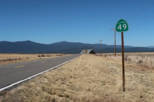
Many of the towns that I drove through on Highway 49, tell of this boom and bust. Some towns would have populations of 3,000 or 5,000 people at their height and then the diggings would be mined out and the town’s population would disappear to the next new gold discovery site. No two towns exemplify this today more than the prosperous town of Columbia and the virtual ghost town of Hornitos.

Gold was discovered in the area around Columbia on March 27, 1850. Columbia became a boomtown with its population swelling to 5,000 with 150 saloons to quench the thirst of parched miners. Over that time $150 million worth of gold was mined from the hills surrounding the town becoming one of the most prosperous areas in California’s Gold Country. At one time, Columbia was the second largest city in California and was once considered for the site of the state capital.

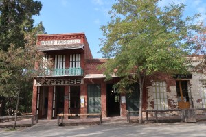
The centerpiece of Columbia State Historic Park, the 1858 Wells Fargo & Company building. More than 1.4 million ounces of gold was weighted out in this building.

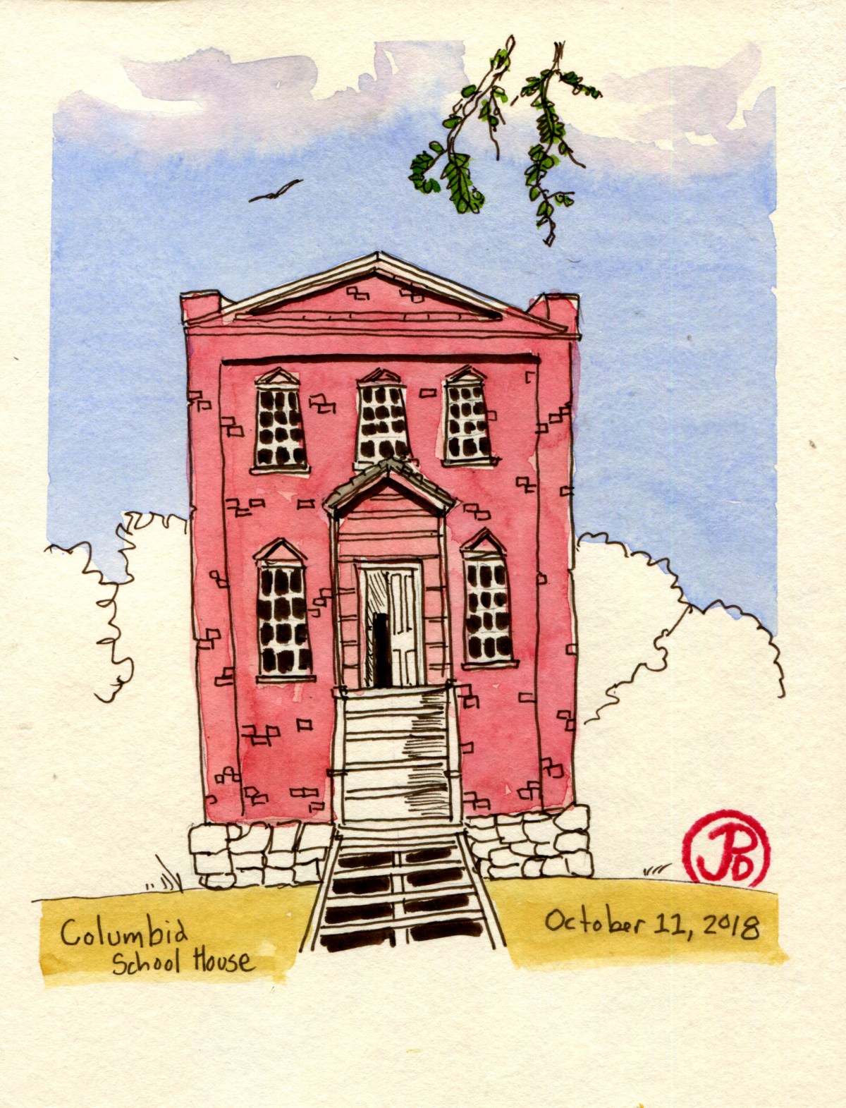
By the 1860’s, most of the gold had been mined out and the population decreased. But Columbia never became a ghost town. The two story brick schoolhouse (built in 1860), which was used up until 1937, speaks to the vibrancy of the town that never gave up the ghost.

In 1945 the state bought the land and preserved the site of the historic downtown as Columbia State Historic Park. It now represents the largest collection of Gold Rush era buildings in existence. Walking down Main Street is to take a step back in time.

During the Gold Rush, Hornitos was known as one of the roughest and toughest towns among the southern mines. The outlaw Juaquin Murrietta is reputed to have used Hornitos as a hideout. The town predates California’s Gold Rush and was founded by Mexicans who were kicked out of nearby Quartzburg. During its height it is said that Hornitos had a population of 15,000 and was the only incorporated town in Mariposa County.

Now Hornitos is a backwater, 13 miles from Highway 49 in what seems like the middle of nowhere. The town, well really settlement might be a better name for it, now has a population of about 60 souls. But as I walked the street of “downtown” Hornitos, the only sign of life were the cows in the far fields and 80’s pop music blaring from a house that looked it had been abandoned back it the late 80’s. At least they have electricity in Hornitos.

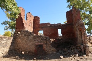
I was standing in front of the building that had drawn me away from Highway 49 to this small town. The red brick building is now just a hollow shell of its former self, a ruins of a former business started by an Italian immigrant. His name was Domenico Ghirardelli and it was in this brick building that his chocolate empire began. Here in Hornitos, Ghirardelli ran a general goods store from 1855-1858 and he sold the store and headed to San Francisco to start his chocolate business.

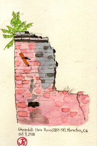
This ruins is a reminder that the people who made money during the Gold Rush were not always mining for gold, they were mining the miners.

Image

Twain in the Gold Country

When Mark Twain’s name is mentioned, steaming paddle boats on the Mississippi River comes to mind. He is, after all, the author of what has been called the “Great American Novel”, The Adventures of Huckleberry Finn. The setting is firmly placed in the Antebellum South. So why is it that on Highway 49, near Tuttletown, there is a historical marker (No. 138) with Mark Twain’s name on it?

It was in California’s Gold County that the 30-year-old journalist, Samuel Clemens (aka Mark Twain) spent the winter of 1864-65 in a cabin up on Jackass Hill. The cabin belonged to the Gillis Brothers, who where local miners. Maybe this fact alone would be worth a historic marker on 49 but it is what he did when he went into town and visited the saloon in the Angels Hotel in Angels Camp, ten miles north of Jackass Hill. What he did was presumably, have a drink and listened to a tall tale.

That tall tale became the short story, “The Celebrated Jumping Frog of Calaveras County”, which was first published in the New York Saturday Press on November 18, 1865. This is the short story that is credited with setting Twain on the road to literary fame. It was in the rainy winter that he discovery his fortune as Twain noted, “right in the depths of [the miners’] poverty and pocket mining lay the germ of my coming good fortune.” He saw his 88 days in the Gold Country as the turning point of his life.

And so it was that I turned off Highway 49 and headed up a narrow road to the top of Jackass Hill. At the top was the Gillis Cabin. The building itself was surrounded by a fence, as if it was an animal at a zoo. The cabin itself is a replica of the original. The original succumbed to the plight of many wooden structures of the day: engulfed in flames. The chimney, however, is original to the time when Twain stayed here.

I set up my folding camp chair and sketched the cabin sans fence. I felt like I was sketching at the zoo. Except my subject stood stock still.

After sketching, I heading back down Jackass Hill and continued north on 49 to the town of Angels Camp. In town I sketched the frog historical marker which is across Highway 49 from the site where Twain first heard the yarn about the leaping frog of Calaveras County and also put Angels Camp on the map. All on account about a tall tale about a frog.

They really celebrate Twain’s short time in the area with Calaveras County Fair and Jumping Frog Jubilee which is held in May. The frog jump contest just celebrated it’s 90th anniversary last May (2018). This event is held in Angels Camp and is billed as one of the oldest such events in California. It is billed as one of the oldest Faires in California.

Image

Miner’s Justice

One of the first sketches I did on my Highway 49 road trip was of the Mariposa County Courthouse. This stunning courthouse is the oldest seat of justice in California. The courthouse was completed in 1854 and has been in use ever since. In fact when I visited the courthouse on Tuesday, I went up to the courtroom chambers above the entrance and they were conducting jury selection for an upcoming trial. I was relieved at this time that I was not a resident of Mariposa County!

Many famous legal battles regarding miner’s rights and claims were fought in this very courtroom and here it was, still in use!

IMG_4623

Solving disagreements in a court of law was a new thing in the wild west of the Gold Rush days. It was was more common in miner’s camps for disputes and crimes to be solved by miner’s “rough” justice. And sometimes on the branch of a oak tree in Hangtown, which now bears the name Placerville. The Hanging Tree is now long gone but further north on 49, 30 monies from Nevada City, I saw Downieville’s version of their hanging tree.

Downieville has the dubious distinction of lynching the only woman in the State of California and it is in Downievillie that it is the only place in California that they have their gallows on display.

Gallows

The gallows was last used on November 27, 1885 when 20 year old James O’Neill was hung to death for the August 7, 1884 murder of his employer John Woodward. This execution was the last legal execution in Sierra County and it was they only time the gallows was used. At the time the gallows was constructed it was only set up temporarily for it’s sole purpose and then it was disassembled and placed in the courthouse attic for storage. In 1891, local executions ended, being moved to San Quentin and Folsom prisons and in 1941 the state banned hanging as a means of execution in favor of San Quentin’s gas chamber. Isn’t history great?!

Image

Highway 49 Road Trip

California Highway 49 runs north and south, winding 310 miles through California’s Gold County. It passes through eleven counties and 51 cities, towns, and settlements. It is perhaps California’s most historic highway and I was going to drive all 310 miles of it, starting at it’s southern terminus at Oakhurst to where the highway ends at it’s northern terminus at the junction with Highway 70 at Vinton.

My guild throughout my road trip was the green, spade-shaped shields that read: CALIFORNIA 49. NORTH. The shape of the sign is a reference to the spades used by Forty-Niners to dig for gold when the world rushed in during California’s Gold Rush in 1849. The state highway agency adopted this symbol of the Gold Rush in 1934 and has been used ever since on all of California’s state highway signs.

The first Highway 49 shield at the start of the highway in Oakhurst on my first day of my road trip.

I could drive the entire highway in one very long day but I chose to break the road trip up into a five day trip, giving me time to explore the towns, back roads, and historical points of interests along the way. And of of course encountering the landscape and townscapes in the same way that many immigrants did in the 19th century, in the pages of a sketchbook.

The northern end of 49 at the junction of Highway 70 in the beautiful Sierra Valley.

In the next blog posts, I will features sketches in the many places I visited on my road trip on historic Highway 49.

The northern section of Highway 49 is the most scenic as it runs through Sierra Valley at 5,000 feet.

Image

Me and a Dipper

I came down to the valley to sketch the monolith El Capitain but instead I stopped at the banks of the Merced River, Bridelveil Falls falling silencing across the valley and I sketched a dipper.

It says a lot about the American dipper that John Muir devoted an entire chapter of The Mountains of California to this small, drab bird. The water-ouzel, as the dipper was known then, rewards the observer with the amount of time put in by simply sitting down on the river bank and watching.

The dipper is seldom still, making sketching a challenging yet exhilarating experience. Just when you start one sketch you stop and restart because the dipper has disappeared under the river, appearing again, perched on a submerged rock, making the bird appear to be standing on water. And the dipper never just perches. Like it’s name implies, it it constantly dipping it’s body up and down.

As so I passed part of my morning in Yosemite Valley, with my back facing the largest chunk of granite in the world but my eyes focused on one of the most captivating creatures to be found in any National Park: the American dipper.

And as Muir wrote about the dipper, “Among all the mountain birds, none has cheered me so much in my lonely wanderings, -none so unfailingly.” And I couldn’t agree with John Muir more.


Image

Obata’s Yosemite

I left the Wawona Hotel before light, my destination was Glacier Point and I hoped to have the place to myself (if that is ever possible in this very popular National Park).

The view from Glacier Point is probably the best view in Yosemite, if not the entire National Park System. Right in front of you, Half Dome rises up and leaning over the rail, you look down into this famous glacier-sculpted valley.

IMG_4670

It was a beautifuly crisp fall morning above the valley and as I sketched Half Dome, I had the point to myself for a whole six minutes! An eternity in Yosemite, these where geological minutes.

IMG_9721

I’ve got the place to myself, well at least for another two minutes!

I chose to use a loose, brush technique, inspired by the paintings and woodcut prints of Chiura Obata (1885-1975). Obata’s images of Yosemite and the Sierra Nevada Mountains, are as iconic to me as a Bierstadt or Hill painting or an Ansel Adams photograph. I love this Japanese ascetic that he brings to a very familiar subject.

Obata immigrated from Japan to the United States in 1903. Obama became a well know teacher and artist in the Bay Area and every since visiting Yosemite for the first time in 1927, this National Park has become a major subject matter in his artist output.

Obata Half Dome

I tried to resist the urge to head to the valley floor which is usually crowded with people, even in October. One of the other most iconic views of Yosemite Valley is the one you get at Tunnel View. While all the tourists took selfies and photos, I sat on a stone wall and sketched this famous view, trying to summon my inner Obata.

Obata Tunnel View

Image

Summer Camp

They say you can never go back to summer camp as an adult but I was sure going to try.

Like most childhood memories, the setting is often divorced from the memory itself. I find this out almost every Monday when I learn that one of my students has gone camping over the weekend. My first question is, “Oh, where did you go camping?” The inevitable answer is, “Ahhh. . . I don’t know.”

I retained certain details from my summer camp experience, which was 30 years ago, like the name of the camp: Skylake, and the lake it was near: Bass and aided by photographs in a album, I have images of people, my councilor Bil, and locations: my cabin and the horse coral and actives: horseback riding, archery, waterskiing, and canoeing, but other than that I had no idea where my summer camp was, other than I knew it was somewhere near Yosemite.

A casual glance at a map reals many lake named “Bass’ in the United States. I looked at a Yosemite regional map and found a Bass Lake just south of the Wawona entrance to the park. A web search revealed that Skylake Yosemite Camp was indeed still in business but under a new ownership. Well I couldn’t go to Wawona without first going back to camp!

All was well when I turned right off pf Highway 41 at the Bass Lake sign. Well this was going to be easy, I thought, one road to the north of the lake and one to the south. What I didn’t take into consideration was that I could not see the lake through the woods. And when I finally did see the lake, it was to my right and I wanted it to my left which meant I was on the north shore and not the south where Skylake was located. Oh bother! As pooh would say.

I figured I would just keep driving east until the road curved around to the south side of Bass Lake but the road kept going east and not south, like I wanted it to. I eventually consigned myself to defeat, turned around and headed back along the north shore on the roadway of shame. I turned left and made a false foray into a housing development, turned back, and stopped at the ranger station and got a map (something I should have done about 45 minutes ago). I finally found the correct road, memorably named Road 222 and headed east along the south shore.

I looked at Bass Lake, trying to connect my memories to the location. The only thing I could come up with was there seemed to be more large house on the north shore than I seemed to remember. Well the last time I was on this road heading in this directions was 30 years ago, aboard a bus loaded with excited campers.

I did remember that there was a picnic area on the shore near the camp and Pine Point Picnic area appeared on my left, I knew I was very close! I rounded a curve and there was the sign on the right side of the road, “Skylake Yosemite Camp”!

I turned up the single track paved road, the ideal scenario running through my mental cinema: I would pull into camp and the off-season caretaker named Gordon (and not Jack) would look up from raking the leaves from the parking lot near the flag pole and welcome me to Skylake. He would commence a grand tour of the camp and memories would come flooding back. Instead I was greeted by a fallen oak, blocking the entire roadway.

I returned to the camp dock remembering a canoe camping trip from 30 yeas ago. I remember setting of in the late afternoon to the northern shore and I remember sleeping under the stars.

IMG_4646

As I drove back towards Highway 41, one final memory came back. It was they day my dad came to pick me up to take me back home. He was the one who took the photographs. I remember it was great to see him and I gave him a our of the camp along with my best friend Erik. I think we must have driven around the lake, no doubt my father stopping along the shore to take photos. Now much has changed.

They say you can never return to summer camp but I tried.

Image

Fall Pelagic

There was a complete absence of fog as I crested the hill down to Pacifica heading south on Highway One toward Pillar Point Harbor. This was not the only difference from my August 18th pelagic trip. A fall pelagic is known for quality not quantity. We would not find the large numbers of shearwaters but the diversity of species should be higher.

When we headed out on the Huli Cat at 7:00 AM, the skies were clear and the winds were light. A nice treat on the way out to the Continental Shelf was to see the entire genius of turnstone on the breakwater: black and ruddy turnstone, perched amount the pelicans and Heermann’s gull.

Once outside of the harbor we started to see our constant companions for this trip, the common murre. The auk was seen bobbing on the swells throughout the voyage. Framed in the blue sky, lines of brown pelicans heading out to fish.

Heading further out, the uptick of shearwaters picked up but not in the same numbers as in August. In some small flocks pink-footed outnumbered the often omnipresent pelagic staple, the sooty shearwater.

At about 24 miles from Pillar Point Harbor we where over the Continental Shelf and we headed north into San Francisco County waters. The skies where covered in low gray clouds and the sea became a little choppy. This made finding one of the targets of this pelagic, Guadalupe murrelet, very tough to spot in between the swells.

There where more storm-petrels seen on this trip than in August with a high of 19 black storm-petrels and 252 ashy storm-petals. These swallows of the seas fly low to the water, picking off food from the ocean’s surface. Some species even seem to “dance” on the water.

I had a few target birds for this trip. Short-tailed and flesh-footed shearwater. Both would be lifers. It is said about the flesh-footed that it takes ten pelagic to see your first flesh-footed. I was hoping to me a little more lucky.

As we were motoring in San Francisco waters, I spotted a lone, dark shearwater on a parallel course, heading in the opposite direction from my perch on the starboard side of the Huli Cat. My first impression was that it was just another sooty until I noticed the bi-colored black and pink bill like a pink-footed shearwater. All the field marks clicked and before I could put it into words a spotter in the stern shouted out, “Flesh-footed!!” And just like that I had a new pelagic lifer!

Another birder on the Huli Cat ticked this shearwater on her list list. Nicole was doing a Big Year and the flesh-footed was the 752nd species she had recorded in the calendar year

A Big Year is an attempt to see the highest amount of birds in a calendar year. According to the American Birding Association (ABA), there are 993 species that have occurred in North America so I have 438 more birds to go!

I highly recommend Alvaro’s Adventures for a pelagic birding trip.