Image

Robinson Raptors

It was again time for our annual trip to the winter raptor hotspot known as Robinson Road in Solano County.

I also used this trip as a field test for my new camera. As a reformed professional photographer, I have been used to top end, professional gear. This gear is very expensive and heavy and cumbersome. Instead I opted for a “bridge” camera, that is a camera between a point-and-shoot and a professional set up. I wanted a camera that was light, took quality images, and had the capacity to zoom into my far away subjects. I settled on the Canon Powershot SX60 HS. All photos in this post were taken with this camera and my sketches were also based on some of the photos.

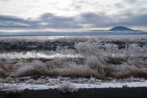
The day started with valley fog but afforded views of a few hundred yards. Good enough to spot perched raptors but not good enough to get raptors up off the ground and into the sky, making identification a little easier.

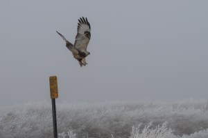
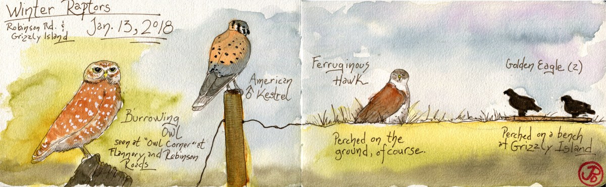
On the first part of the journey we had seen the usual suspects: red-tailed hawk and American Kestrel. There was no sign of ferruginous or rough-legged hawk. It wasn’t until we paused at “Owl Corner” that things became interesting. I call the intersection of Flannery and Robinson Road “Owl Corner” because it is always reliable for this gem:

B OwlBurrowing owl is always a welcome sight at this intersection and this trip, again, proved to be fruitful.

After taking a few photographs with my new field camera (the above photo is an example), we headed off to look for other raptors on our target list.

It wasn’t long before I spotted a raptor on the ground in the pasture to the right. It was one of our target birds, Buteo regalis, the ferruginous hawk.

IMG_0062A typical view of our largest buteo hawk from Robinson Road. Perched on the ground.The zoom on my Canon Powershot SX60 was able to bring this far off raptor, a little closer for a diagnostic view of this wintering  hawk.

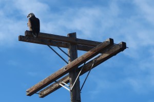
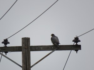
We drove the circuit but could not find mountain plover or any roughies. Mountain plovers looked like small clumps of dirt and could be very hard to detect. We did have a nice surprise as a Peregrine swept the landscape and alighted on a power pole. So I took a few pictures.

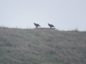
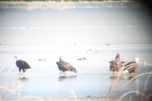
We left Robinson Road and headed towards Grizzly Island. Off to the left, perched on a ridge, was an unmistakable profile: golden eagle. Two, in fact.

Image

Where the River Ends, a Gull Bath

I headed to the bluff on the east side of the San Lorenzo River. This is where the river ends into Monterey Bay.

On my left was the Monterey Bay and beyond was the Municipal Wharf (sight of great fork-tailed storm-petrel sightings last year) and to my right was Santa Cruz Beach Boardwalk, now in winter dormancy. I knew that any time a large river entered the ocean, where fresh water meets salt, there would be bathing gulls. Lots of gulls.

Down below, there were hundreds of gulls. This multi age and many specied gathering contained mainly California, herring, mew, and western. I scanned the gathering and found no rarities. But it did give me an opportunity to observe the dynamics of gull bathing and preening.

The mighty San Lorenzo River is a major winter gull bathing and resting location on Monterey Bay. The Santa Cruz Beach Boardwalk is on the west side. The Logger’s Revenge to the right and my favorite roller coaster, the Big Dipper, is on the left.

Using my not-so-secret powers of observation I noted two areas that the gulls used: river and sand. The river is used for washing and the sand for preening, resting and playing.

The gulls used the river right in front of the railway trestle which was featured in the 80’s vampire flick Lost Boys. The birds were doing their indelible flappy wing dance followed by a head plunge and a wiggle. Yes very scientific I know.

The gulls on the sand spit where resting or preening. I noticed a few juvenile gulls playing with slicks on the spit point. They would carry a stick around and then drop it and pick it up. Repeat. I can only guess that they are practicing their eye-beak coordination.

The spread I sketched was a not-to-scale gull’s eye view of the river mouth. I love to make my own maps, using my own names for the land. This map contains my own: Seaweed Island, the “Wash”, Stick-Grab-Point, Gull’s Rest Spit, North Spit, and the “Stump”. Most of these land and watermarks are ephemeral, changing and disappearing with the tides and the winter rain, washing down from the Santa Cruz Mountains.

Image

The Klamath Basin

Why would anyone drive to the California-Oregon Border with daytime highs perching precariously in the low 30’s and drive on a muddy road in the middle of no where with visibility down to 50 yards? The answer is simple: Winter raptors!

I started my trip at Lower Klamath National Wildlife Refuge. President Teddy Roosevelt established this refuge in 1908, becoming our Nation’s first waterfowl refuge. The Refuge was designated a National Historic Landmark in 1965. The refuge contains 50,912.68 acres, which straddles the border of Oregon and California.

The winter raptorland that is the Lower Klamath Wildlife Refuge. Looking south east from the auto route.

One the first day I arrived the visibility was down to 50 yards, making raptor spotting very difficult. My scope would remain in the truck, I didn’t need a closeup view of wintry gray.  Luckily there were a few raptors perched by the roadside of the auto route. None was more wintery than the raptor with leg warmers: rough-legged hawk. This Arctic breeder winters in Northern California and I was lucky to encounter one perched on a road sign, which allowed a close approach in my moveable blind.

Buteo lagopus vacating a roadside sign showing two identifying field marks: feathered legs and a carpal patch. Note the “wonderful” visibility in the background.

The really star of this raptor wonderland is our National symbol, the bald eagle. The Klamath Basin holds the largest winter concentration of bald eagles in the Lower 48. Winter counts can be between 500 to 1,000 individuals. Their peak numbers were still a few months away in late February to early March, a time that coincides with the northern migration of waterfowl.

All of us in the United States are familiar with this bird, indeed it must be the most recognizable bird to all North Americans (yes I also mean youth, dear Canadians). It is on our stamps, posters, trucks, mudflaps, flags, paintings, sculptures, etc. But to see one, let alone a convocation of eagles, is a life experience that all Americans should have. That also includes you, Central and South!

On the first day, full of chilling ground fog, I saw five eagles. But what a difference a day would make.

After a nighttime roost in Oregon at Klamath Falls, I parted the curtains to find the dense ground fog had flown. I changed plans and headed back to the Klamath Basin.

On my second day, the roads and vistas were clear. Perfect for winter raptor spotting. And I had many.

This day can be summed up with one location: Tule Lake. A binocular search made it clear that I needed to set up my scope for a closer look across the frozen surface of Tule Lake. In one 180 degree scan, from the north to the south, I counted 30 bald eagles!

Not the best photo, but this digiscope photo confirms the most bald eagles seen in one view: four! 

Here is the total raptor count for both Lower Klamath NWR and Tule Lake on the morning of December 27:

50 Bald Eagle

33 Red-tail Hawk

14 Northern Harrier

7 American Kestrel

3 Rough-legged Hawk

1 Peregrine Falcon

1 Cooper’s Hawk (being harassed by a kestrel)

An adult bald keeping watch at Tule Lake, Klamath Basin.