Image

Black Friday, Point Reyes

On Black Friday I headed west onto the Pacific Plate. I was seeing how far away from a Marin shopping mall I could get without leaving Marin County. I figured the Outer Point at Point Reyes National Seashore would be the place.

invernesspr

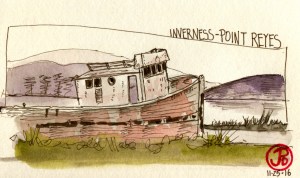
On my way out to the point, just after crossing from the North American Plate to the Pacific Plate, I stopped on the western shore of Tomales Bay at one of the “larger” towns in Point Reyes: Inverness. I pulled into the parking lot behind the general store. My subject was one of the “tourist attractions” of Inverness, the boat known as the SS Point Reyes. For over 50 years this fishing boat has been beached on a sandbar and has been attracting tourists, photographers, and artists ever since.

gholpr

I continued on towards the lighthouse and Chimney Rock. I passed some of the historic cattle ranches along Sir Frances Drake Boulevard. Whenever I am in the area I always stop in at Historic Ranch B, also know as Mendoza Ranch. I walked up to the cypresses to see the local great horned owls. I easily found the pair and I sketched one of the roosting owls.

The Outer Point is a world famous birding location known for its rare fall migrants. 410 different species of birds have been found here. Most of the migrants had already passed through but highlights included: a pair of peregrines at the lighthouse, a rock wren near the lighthouse parking lot, a Say’s phoebe on the way out to Chimney Rock, and a barn owl that was flying well past it’s bedtime at Drakes Beach.

I went as far west as physically possible in Point Reyes while still remaining dry: the Point Reyes Lighthouse. I sketched the lighthouse while watching a pair of peregrines that where perched on the cliffs above the common murre colony. One lifted off and spiraled upwards and then headed east towards Chimney Rock. Like the wanderer, I too headed to Chimney Rock.

img_5829

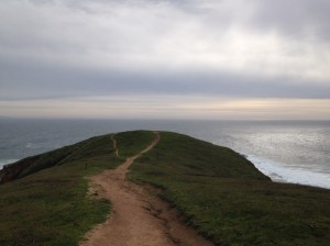
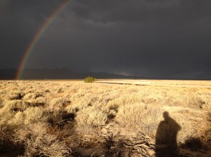
Looking out towards Chimney Rock, Drakes Bay, and the Pacific.

Image

Lonesome Whistle

“I’ve been down the road and I’ve come back

Lonesome whistle on the railroad track”

-Neil Young – Mellow My Mind 

On a recent visit to Santa Cruz I decided to sketch the utterly mundane. The parts of the cityscape that most people ignore and are blind to. Things that, in some cases, are obsolete but still standing. So on one Friday morning I set out to sketch railway signs, and Santa Cruz has quiet a few.

These signs speak of a time when trains passed through town on the now closed branch lines. One line, known as the Suntan Special, once threaded it’s way through the Santa Cruz Mountains to Los Gatos and brought beach goers to the coast in the age before the automobile reigned supreme and another line headed out to Davenport to the now closed cement plant.

My father used to relate the memory from his childhood, of hearing a steam engine, working it’s way up the wet rails, just up the canyon from my cabin and how the driver wheels would spin out and the train would have to back down the grade, sanding the tracks, to make another attempt.

But today, on that same grade the tourist train dubbed Big Trees & Pacific now takes passangers on a motley consist from Felton to the Santa Cruz Beach Boardwalk and back again.  But really this lines goes nowhere, like an ocean going vessel on a landlocked reservior. 

Railway tracks speak of the romance of the rails, about hope, about hopping a freight to a new chapter, a new life. And the signs are still there, if you know where to look, and I do. 

Image

Lifebirds of the Southwest

Shortly after touchdown at Las Vegas International Airport, I had one destination on my mind and it wasn’t the Strip. I took the shuttle to the car rental center and 45 minutes later, I was on the road, my binoculars on the passenger seat, and I was heading to one of the best birding locations around Las Vegas: the Henderson Bird Viewing Preserve.

I had two notoriously difficult birds on my wish list that I hoped to see at the birding center. Because of their secretive nature, crissal and Le Conte’s thrashers were a prize on any desert birding trip to the southwest.

On my arrival at the visitor center I was informed that Le Conte’s was not to be found here but crissal could be seen just beyond the fence on the other side of Pond 6.

The Birding Preserve is an oasis of 9 ponds in the desert, southeast of the Vegas Strip and directly east of the airport. I threaded my way out to the far side of Pond 6 and walked the fence line, looking for the secretive thrasher.

In a near bush I spotted a little mouse of a bird, seen in a pair, it was a desert gnatcatcher, the black-tailed gnatcatcher. Life bird number 506.

black-tailed

After watching the gnatcatchers, I scanned the brush for any sign of the thrasher and listening for their musical desert song. Then the thrasher appeared on top of a bush near the fence line and I had great looks of this fleeting enigma. It flew from bush to bush and I stayed with the bird for about ten minutes then I headed back to the visitor center, the preserve closed at 2:00 and I was warned that I would be locked in if I didn’t return in time. A roadrunner was a nice treat on my way out.

crissal-thrasher

Life bird number 507, crissal thrasher (Toxostoma crissale).

Two lifers in Las Vegas was not a bad haul and the other lifer I could expect to find was in Zion National Park, two and a half hours away. This bird was not rare and unlike the thrashers, was very conspicuous and easy to see. Indeed this bird was “created” by the American Bird Association (ABA), as it was split from the western scrub-jay. All scrub-Jay’s were once considered one species but are now broken up as Western, Florida,  Island, and now Woodhouse’s.

I didn’t really look for Woodhouse’s, I just knew that eventually we would cross paths somewhere in Zion. This I did while returning from Emerald Pools on the Kayenta Trail. I later have better views of a different jay on the Pa ‘rus Trail. This jay looks exactly the same as the western but favors juniper over oaks and there is no range overlap in southern Utah. Easy lifer.

woodhouse

Woodhouse’s jay, life bird number 508.

I was going to try one more time for the elusive Le Conte’s thrasher. This involve getting up extremely early, and leaving Springdale by 6 AM, so I could make my 1 o’clock flight from Sin City (turns out the flight was delayed by two and half hours because of Bay Area weather). My destination was the entrance road to Corn Creek, north west of Las Vegas. This is a hotspot, according to ebird, for this species. I waited as an approaching thunderstorm bore down on me. I searched the brush that flanked the road, and I heard it’s contact call but I never saw the  ghostly pale phantasma of a bird. It just gives me a bird to look for on my trip to Joshua Tree during my winter break.

img_5767

I may have heard a Le Conte’s thrasher at Corn Creek but the elusive bird was not seen, instead I was treated to one of nature’s masterpieces. Sun, rain, thunder, lighting, double rainbow.

Image

My 100th Post: North America’s Sexy Megafauna

One of the fauna highlights of Bryce Canyon National Park is the possibility of seeing North America’s fastest land animal: the pronghorn antelope. As I headed out to Rainbow Point I stopped to scan every roadside meadow to see if I could find a herd but with no luck.

On my way out of the park I stopped at the visitors center to ask a ranger about possible locations to see pronghorns. The ranger told me that he hadn’t seen any pronghorns in the park for three weeks and in the fall the antelopes head out of the park and sometimes can be seen from the highways near Bryce,  grazing with cattle.

So I stopped at the first field I came to, once I left the park. There were cattle grazing in the field and I walked over to the barbed wire fence to take a closer look. That’s when I spotted a pronghorn, although not one I really wanted to see.

img_5716

The pronghorn that once was. Even in death, the pronghorn looks gracefully fast. 

I headed west on Highway 12 and stopped near the airport and again scanned the planes (no pun intended) for the Northern Hemisphere’s fastest land animal. No luck. I stopped at a few more locations in Red Canyon and the Dixie National Forest.  As I neared the intersection with highway 89, I spotted a lone pronghorn in the field to the south.

I pulled over and crossed the highway to take a closer look. That’s when I noticed that the pronghorn was not alone. Stretched off to the west were about 20 antelope, all of them looking towards the strange man looking at then. A new life mammal!

pha

After watching the herd for 10 minutes I got into the car and headed south on 89, towards the east entrance to Zion National Park. Little did I know that I would soon seen another life mammal. This one would be much closer to the road than the skittish pronghorn antelope.

Just after entering Zion National Park,  Checkerboard Mesa looming off in the near distance, I headed toward the mesa vista point. A line of tan animals appeared on the left side of the road, threading their way down to the mesa. They looked like large, pale capybaras, but with horns. What on earth were these creatures?

img_5741

A herd of bighorns attack a helpless bush on the road side of the Zion-Mt. Carmel Highway.

I pulled over and was surprised to see a herd of desert bighorn sheep descending on a bush at the base of Checkerboard Mesa.

The were about 15 sheep in the herd and a few worked their way up the road bank to almost within touching distance.  There was another herd on the other side of Checkerboard Mesa and this group included a ram. 

Image

Bryce Canyon

On my last full day in southern Utah, I lit out of Zion on the Zion-Mt. Carmel Highway, heading in a northern eastern bearing. My destination was Bryce Canyon National Park.

“Otherworldly” is an adjective often used to describe the landscapes of Bryce Canyon. Over a long period of geologic time of freezes, thaws, and erosion, the sandstone and limestone pillars known as hoodoos, were formed.

I wanted to get up close and personal with some of these hoodoos, so I got out of my car and left the vista point at Sunset Point and hiked the Navajo Loop Trail. There among the hoodoos and alien moonscapes I perched on the edge of the trail (trying not to drop my sketchbook and/or pen) and sketched Bryce’s most emblematic hoodoo, “Thor’s Hammer”. I let the form of “Thor’s Hammer” stand unpainted as I painted in the background with a loose wet-on-wet wash.

After my hike I returned to my car and headed south on the Bryce Canyon Scenic Drive toward Rainbow Point. As I passed the many vista points along the way I realized that Bryce was a Winnebago Warrior type of National Park. That means it is full of big cars, trucks, and campers that see the park from the road. They spill out of their RV, walk 15 yards to the scenic vista point, take a few pictures, and return to their RV and drive off to the next vista point.

I met a group of these Winnebago Warriors at Rainbow Point. I stopped to admire one of my favorite birds, a raven that was perched near the vista point, quietly quocking to the hoodoos. I recorded the dialogue with a lady:

Tourist: What kind of bird is that?

Sketcher: Common Raven.

Tourist: So you think it’s a raven?

Sketcher: No, I know that it’s a raven.

Tourist: (To her friend) It’s just a raven. You don’t need to take a picture.

This conversation seemed so different from Zion where a lecture on Ravens was being advertised on the Park’s bulletin boards. The talk, which featured a reading of Poe’s poem, “The Raven”, was being held on an auspicious date, October 31st, Halloween at the Zion Lodge.

bryceraven