My base camp for my time in Lassen was Cabin Number 4 at the Mill Creek Resort.
The resort is located 12 miles south of the Lassen Volcanic National Park southern entrance. It was 25 miles from gas and groceries in the metropolis of Chester.
The resort was first opened in 1936 and featured a store, gas station, and a post office. The current resort has nine cabins, eight RV sights, and 17 tent campsites. The twelve acres includes a stretch of Mill Creek.
After almost six months of distance leaning one thing that really appealed to me about Cabin 4: no WiFi! I was more that ready to get away from screens and start to enjoy the rustic.
No more work email, useless YouTube videos, political ads, or any ads. Just a view from the front porch, a book, and my watercolor journal and sketching kit.
A sketch of cabins Five and Six at the Mill Creek Resort
The true test came on Wednesday evening when word came that PG&E was going to be shutting off the power because of high winds for three day. It was about to get really rustic!
One Wednesday I was in the middle of reading the poem “Traveling through the Dark” by William Stafford when the power went out at 7:35 PM. This was uncanny, irony of the highest order!
I turned on my headland and finished the poem which ends:
I thought hard for us all—my only swerving—, then pushed her over the edge into the river.
The unmistakable profile of the American dipper on the Mill Creek. The trail lead down the hill to the creekside.
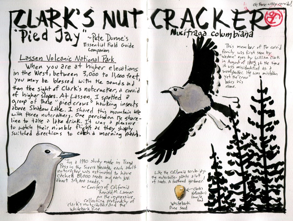
Being a birder, I always keep an eye out for birds, even when hiking, and not birding, is my primary aim. One might argue that a birder really never stops birding. I like to select a bird species as “Bird of the Trip”. This could be an iconic species or it could be a common species showing interesting behavior. The Clark’s nutcracker hits both of these targets.
The Corvids(not Covid) were well represented at Lassen. Common ravens patrolled the Lassen Volcanic National Park Highway, Steller’s Jay were seen at most locations. While I do love seeing these species, I can see them from the deck of my cabin in Santa Cruz. One Corvid encounter was a nice surprise, a family group of Canada jays (formally gray jay) forging on the ground near the Lassen Trail monument. The Canada Jay is a species that I do not see very often because they only occur in far Northern California.
The Clark’s nutcracker is an interesting bird for many reasons. When it was first seen by western eyes during the Lewis and Clark expedition in August 1805, William Clark first described a bird as a woodpecker. He wrote in his journal on August 22 1805:
I saw to day [a] Bird of the woodpecker kind which fed on Pine burs it’s Bill and tale white the wings black every other part.
It is odd that this Corvid, now bears the name of a man who misidentified the nutcracker. This bird is more a cracker of nuts than a pecker of wood!
This hearty corvid is found in the western United States, Clark’s first sighting was in present day Idaho and the bird is found at high altitude from 3,000 to 11,000 feet in elevation. I always keep an ear and eye open when I’m at altitude in the west. I usually hear them before I see them.
This was the case as I heading up the trail to Bumpass Hell on my first hike in Lassen. Off to my right, over a deep ravine, I heard the raucous call of the Clark’s nutcracker. A pair of these pied crows crossed over the trail and alighted on a rocky cliff. They stayed in sight for a few minutes and then crested the rise and dropped over the hill.
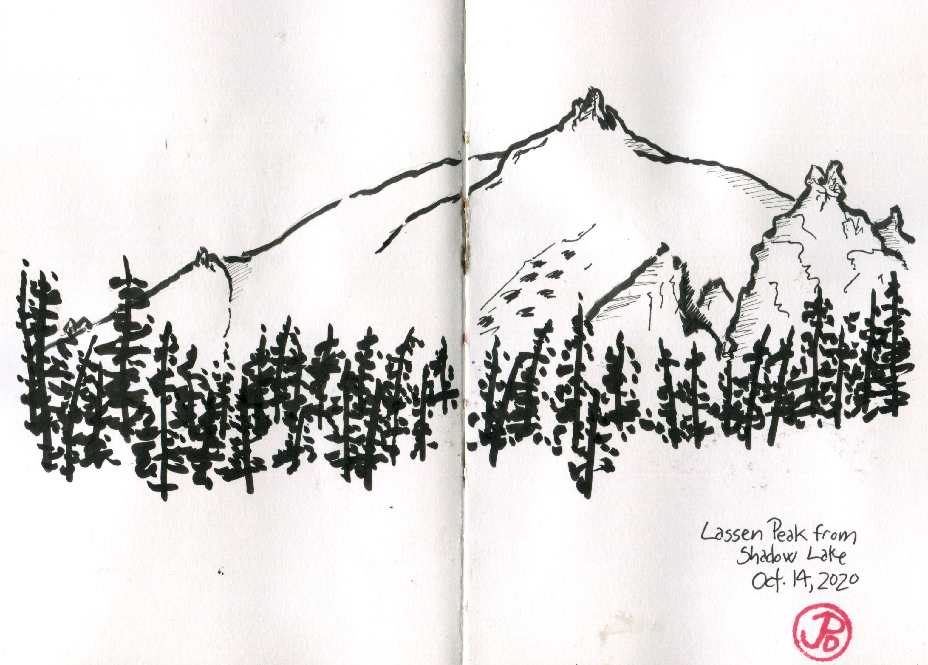
On another day I hiked out to Terrace and Shadow Lakes. I sat on the shore of Shadow Lake to have lunch. From the lake I had a great view of Lassen Peak and it’s twin reflection in the calm, still waters.
After six months of shelter in place and distance-learning, the solitude and stillness of Shadow Lake was exactly what I needed. No technology, no screens, just pen and paper and a perspective to recreate. I sketched the peak of Lassen.
A sketch of Lassen Peak I did while relaxing at Shadow Lake. I thought of adding watercolor but I just left the ink work. Most of this sketch in done with a brush pen.
Soon the silence was broken and up the the way, I heard the call of Clark’s “woodpecker”. I was captivated as I watched a pair of Clark’s nutcrackers hawking over the lake, catching insects in their dark bills. I was astonished by the liquidity of their flight as they quickly changed course to catch an insect.
One nutcracker flew down to a short conifer near me. It looked around and then flew down to the shoreline and took a quick drink. The nutcracker repeated itself two more times before returning to hawking insects.
The work ethic of this bird should be then envy of any fourth grader (and everyone else). In a study conducted in Tioga Pass (east of Yosemite Valley) an adult nutcracker was estimated to cache 89,000 pine seeds and a juvenile buried 34,000 seeds. They prefer the seeds of white bark pines, which are very high in calories. Like the California scrub-jay, the nutcracker is a feathered gardener.
A quick nutcracker sketch in the visitor’s book of Cabin No. 4 at the Mill Creek Reseort.
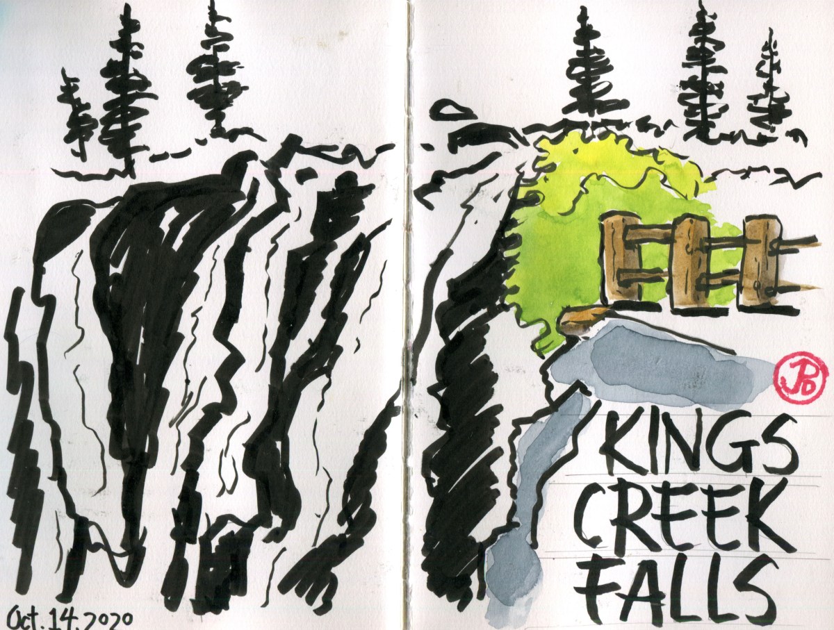
When I pulled into the parking area of the trailhead of Kings Creek Falls at 8:30 AM, there were no other cars there.
One hiking guide listed this hike, in usage, as “heavy” but on this October Wednesday, I had the trail and the falls, all to myself.
The idiom, “the early bird gets the worm” is true for a reason. While others are sleeping in, having an extra pancake, or puttering around with gear, I was on the road by 7:40 AM. Nothing ruins an experience with nature than hordes of people. Yosemite Valley in June, for instance.
The weather was brisk in the early morning hours but the skies clear as I passed through the lovely golden meadows, bisected by Kings Creek. I was heading downstream, towards the 50 foot drop of the Kings Creek Falls.
I once heard that the difference between a creek and a brook is that you can jump a brook, without getting your feet wet. If I were to jump Kings Creek, even with a lively run up, I would land near the middle, with my boots fully immersed in creek. Kings Creek definitely was a creek verging on the edge of being river.
As I hiked, I shed a layer and sweat was beginning to line my brow. The morning was warming up and I came to a trail junction. The trail to the right was a steep and narrow rocky staircase which was oneway. The trail to the left was the trail that left the creek but eventually return to the water course and led to the recently installed King Creek Falls Overlook.
I could hear the roar of the waterfall before I saw it. In 2015, improvements were made to the Overlook area. I assume the building of a fence (featured in the sketch to the right) was to allow visitors to safely get a view of the falls without falling over the edge!
I picked my spot and started to sketch the falls. I kept the sketch loose, it is a sketch after all. I like to work in pen brush, leaving the white of the paper as the water and using the darkness of the pen brush to fill in the shadows and define forms.
During the whole sketch, I had the overlook to myself. When I finished I walked downstream to get a lower perspective of the falls. These falls were certainly impressive but later in my trip I would see some of the most amazing falls in the state of California. (I’m not talking about Yosemite Falls).
Now it was time for one of the surprisingly rewarding parts of the hike, the return journey along the Kings Creek Cascades on a steep and narrow stone stairway.
A view of from the return journey on the stone staircase.
It was an invigorating climb, with many places of wonderment and rest. The narrow canyon was filled with the sound of water rushing over rock.
On my return I encountered a trickle of people, heading for whence I came. They had finished their pancakes and their gear was now in order. The more people I passed on the way out, the more I appreciated my one-on-one time with one of Lassen’s most popular sites: Kings Creek Falls.
The magma in Lassen is still there; visibly in the form of rocks and boulders scattered around the park. But molten magma still exists below the surface.
The magma is the same that fueled the eruption of Lassen, just over 100 years ago. In places, the magma hyper-warms the ground water and rises to the surface through hydrothermal features, reaching temperatures of 200°F. In this sense, parts of Lassen resembles our first National Park: Yellowstone.
The most well-known hydrothermal feature in Lassen and also the most popular is Bumpass Hell. This is a must do hike for a Lassen visit which explains its popularity.
The Bumpass Hell Boardwalk. And not a soul in sight!
I headed out early on a Tuesday morning and I had the trail almost to myself. There was one couple that was just ahead of me. If I would have left later in the morning or in the afternoon I probably would have not have been able to find a parking spot in the trailhead parking lot. Even in October!
The hike is a moderate 3 mile, out and back hike with great views of the south of peaks such as Brokeoff Mountain.
Once you crest a rise, you seem to be in a different universe. Bumpass Hell is a visceral experience. Sight: the steam rising into the morning sunlight and the intense earthy colors surrounding you. Smell: the rotten egg stench of sulfur, and sound: the bubbly cauldron burbble of intense heat erupting to the surface. We are definitely not in Kansas anymore!
Another location that is a release valve of Lassen’s subterranean heat is in a under-visited area of this under-visited National Park, located in the Warner Valley.
To get there you must drive east to the rural metropolis of Chester (compared to the blip of Mineral [population 292]). From Chester (population 2,116) you head north back into the National Park on a road that, at first, is nicely paved and then gets a bit rutty before becoming completely unpaved for the final three miles.
I was finally at the Warner Valley trailhead at the campground, which was now closed for the season.
The most exciting thing about this trailhead is that it joins up with a part of the Pacific Crest Trail. The PCT is 2,650 miles long, reaching from the Mexican border to the Canadian border. This hike passes through the states of California, Oregon, and Washington. A through hiker would take about five months to complete the trail. It’s midpoint lines close to the metropolis of Chester. The midpoint is also the meeting place of the Cascade and the Sierra Nevada Mountain ranges.
Near the midpoint if the Pacific Crest Trail.
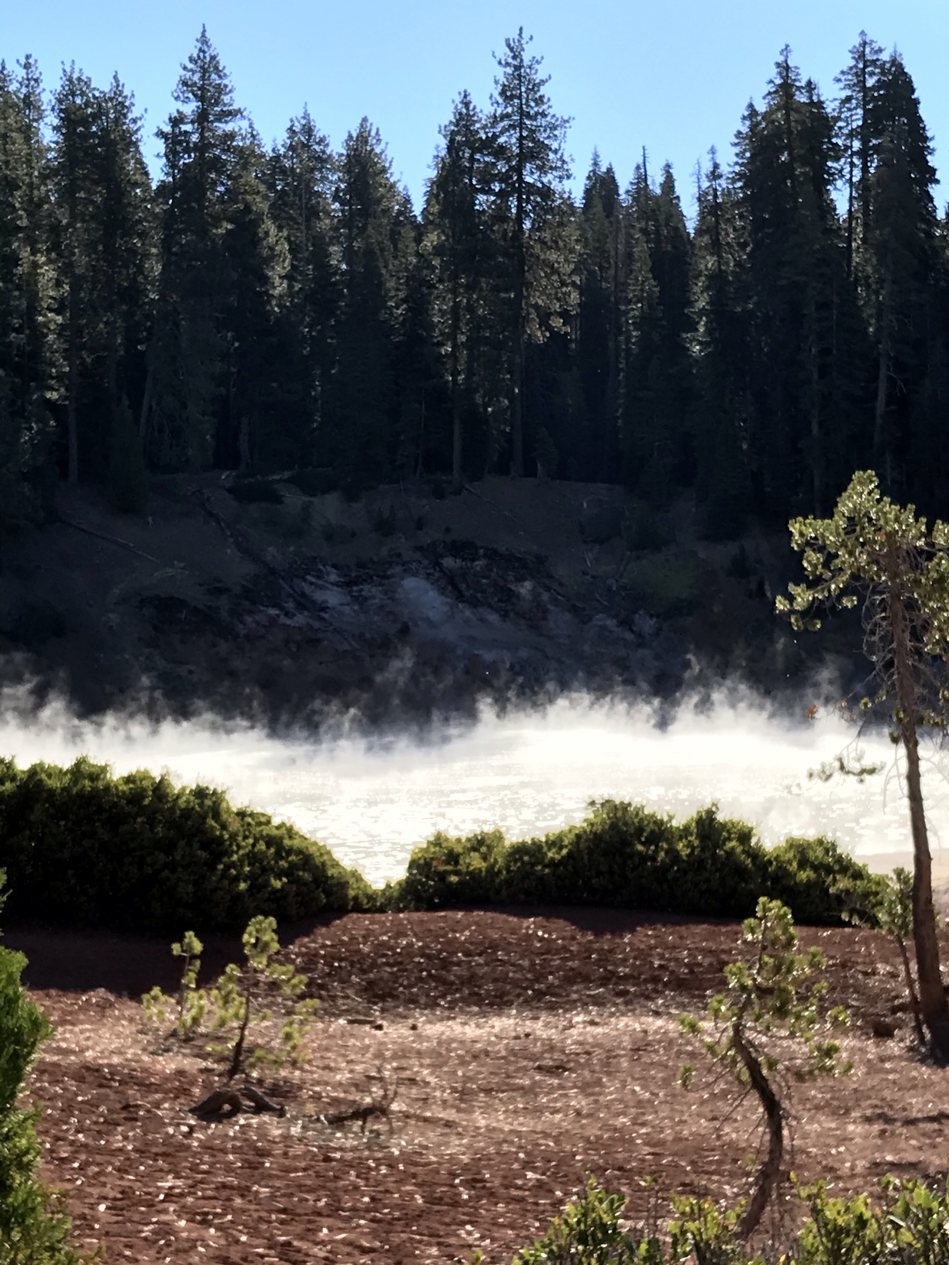
So now I can say that I hiked the PCT, well a very small part of it anyway, from the trailhead to another one of Lassen’s exciting hydrothermal features: Boiling Springs Lake. This is an apt name for this clay colored lake that, in places, resembles a witches cauldron.
Smoke on the water at Boiling Springs Lake.
As I approached the lake, steam rose up into the morning sun and as I got closer, but not too close, I started to hear the bubbling of the mud and smell the tell tale smell of sulfur.
I hike halfway around the lake to a rise on the far side of the lake. From my position I had Boiling Springs Lake in the foreground and Lassen Peak in the background. And I did what any sketcher do, I sketched!
Lassen was the final National Park in California that I needed to visit in order to visit al the National Parks in my home state. It always seemed less well known and remote than other parks in the state, with the exception of Channel Islands National Park because you have to take a one hour boat ride to get there. California has the most National Parks in the Union with nine.
Lassen Volcanic is an apt name for this National Park because volcanos and Lassen Peak dominate the landscape of this northeastern part of California.
A pre-trip sketch of the four types of volcanos and their examples, found in Lassen Volcanic National Park: Cinder Cone (Cinder Cone) Composite (Brokeoff Mountain), Shield (Prospect Peak), and Plug Dome (Lassen Peak). Lassen Peak is the largest example of a Plug Dome volcano in the world.
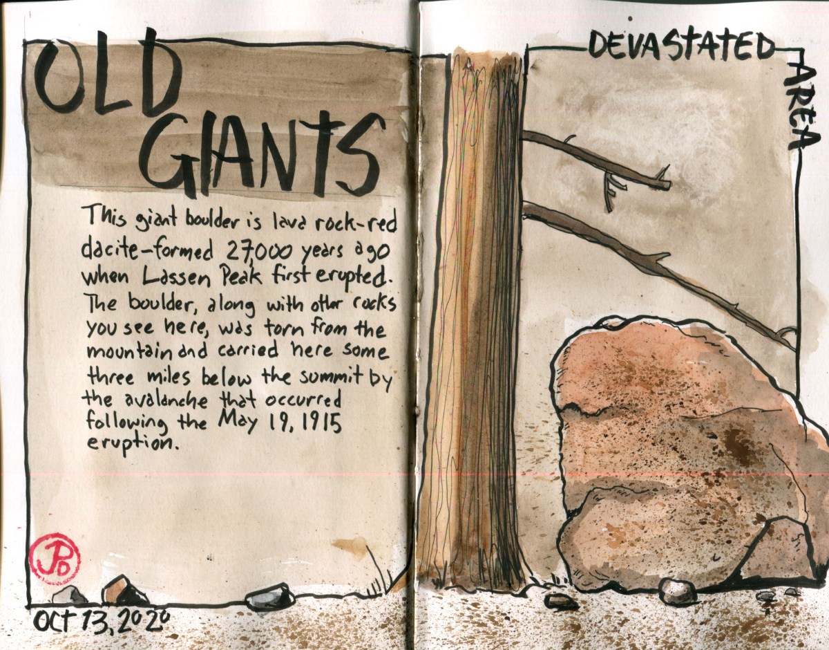
This 106,000 acre park features all four types of volcanos and Lassen Peak represents the last volcano to erupt in California. Even through that was just over one hundred years ago, that eruption, or more accurately, eruptions, left its mark all over the landscape. This is easily seen in the part of the park northeast of Lassen Peak called the Devastated Area.
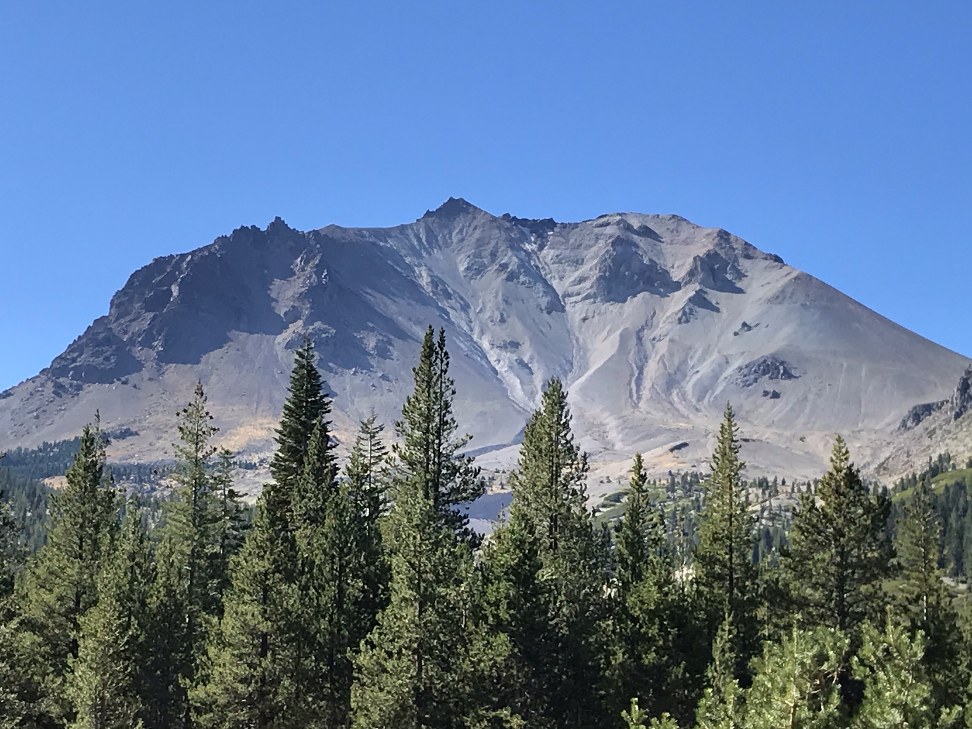
The view of Lassen Peak from the Devastated Area.
The short interpretive trail features giant boulders that had travelled over three miles to find their angle of repose after an avalanche on May 19, 1915. Some of the massive boulders are estimated to have travelled at over one hundred miles an hours on their journey from the summit.
Lassen was active between 1914 and 1917 but it’s largest eruption occurred on May 22, 1915 when a massive eruption sent gas and ash 30,000 feet into the air. The eruption could be seen 50 miles away to the west in Anderson. The flows headed down the Lost and Hat Creek waterways, destroying everything in it’s path. This is now the area called the Devastated Area. The trees and vegetation has grown back but the large volcanic boulders tell of a turbulent time.
I picked a spot on the ground near the trail and sketched a large reddish dacite boulder formed about 27,000 years ago. Reading about this boulder’s journey helped understand these erratic rocks. It’s reddish hue reflected the origins of it’s birth, the reds I was seeing at the peak of Lassen.
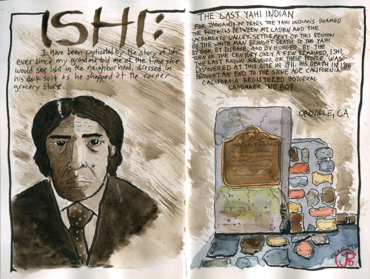
On this Indigenous People’s Day I visited a historical marker to one of the most well known indigenous person in California.
I remember the stories my grandma told me of the man in a suit that she would see in the local corner grocery store in the the inner Sunset neighborhood in San Francisco. He was different but covered in the threads of the times. Although she had seen him as a child, the story she told me in her later years showed what an impression that experience had made on her.
This was the man named “Ishi”, the last surviving member of the Yahi People. And I was going to the point of his intersection with the modern western world.
How did he come to live in San Francisco? It began on an August evening at about 7:30 in eastern Oroville.
On August 29, 1911, Ishi collided with he western world when he was captured near Charles Ward’s Slaughterhouse (note the irony) in Oroville, California. He was captured and put into the Oroville jail (supposedly for his own protection) when the first photograph of him was taken of.
Ishi’s people, the Yahi, had been diminished by attacks by other native tribes and by white settlers who came to California to seek their fortunes in the Gold Rush. His small family group died out and he wandered down from the foothills, tired and dehydrated, to look for food when he was captured.
Ishi at the Oroville jail.
In September, Ishi made his way to San Francisco where he stayed at the University of California Museum of Anthropology at Parnassus and was studied by an anthropologist named Alfred Kroeber. Kroeber learned from Ishi about his culture and language (no living person spoke his language). His voice was recorded as he talked, sang, and told stories.
One favorite story is about the time that Ishi was riding in a car through Golden Gate Park and he made the driver stop the car as he spotted California quail by the side of the road, a bird Ishi would have been very familiar with. Today, there is only one quail remaining in Golden Gate Park, a lone male, which local birders have named “Ishi”.
Ishi’s contact with the modern world proved to be his downfall. He was often sick with western diseases. He died on March 25, 1916 of tuberculosis.
The area where Ishi was found is now a quiet residential neighborhood on a quiet street. The slaughterhouse in gone and the area has been built up with residential, single family houses. The calls of the northern flicker, California quail, and the acorn woodpecker may be the only things recognizable from 1911. At least to Ishi.
Now there is a historical marker, the genesis behind it’s creation was a high school teacher and his son, who wondered why there was not a historical marker about the last of the Yahi: Ishi. And because of their efforts, there now is California Registered Historical Landmark No. 809.
Looking at this marker now, I reflect on our complicated interactions with the native people of California. It is often a tragic story but also with bits of light and wonder. Like the time a little girl saw the man from Parnassus in the local store. A story she would tell, many, many years later to her grandson.
Before most trips I like to create a map of my travels in my journal to help me get the lay of the land. For my fall break I decided to keep it local and visit one of California’s least visited National Parks: Lassen Volcanic National Park. This remains the last National Park in California that I have yet to visit.
This National Park gets about 500,000 annual visitors compared to Yosemite’s 4.4 million. It can be hard to find solitude among the masses at Yosemite, which is California’s most visited National Park. So I was looking forward to the solitude I would find on the trails, lakes, and meadows at Lassen during the fall.
Volcanoes dominate the landscape, history, and name of Lassen Volcanic National Park. The volcano in question is the last volcano to erupt in California and only the second volcano (the other is Oregon’s Mount St. Helens) in the Continental United States to erupt in the 20th century. This of course is Lassen Peak.
This is a sketch taken from a famous Benjamin Loomis photograph of Lassen eruption in 1914. This is also the first sketch in my Stillman & Birn Zeta Series watercolor journal. I love breaking in a new journal and I hope to fill it’s pages with Lassen sketches.
The first major eruption of Lassen occurred on May 22, 1915 and ash was spewed high in the air drifting as far east as 280 miles. Lassen continued to be active until 1921. In August of 1916, Lassen became a National Park and Lassen became a sleeping giant.
The landscape around Lassen still show signs of the last eruption in the early years of the 20th century. I can’t wait to sketch this volcanic history.