When it comes to train vs car, the train always wins.
In 2019, there were 2,216 collisions at railroad grade crossings. There are about 200,000 grade crossings in North America.
This number would be much, much higher without the safety equipment at the point where roadway and railway meet.
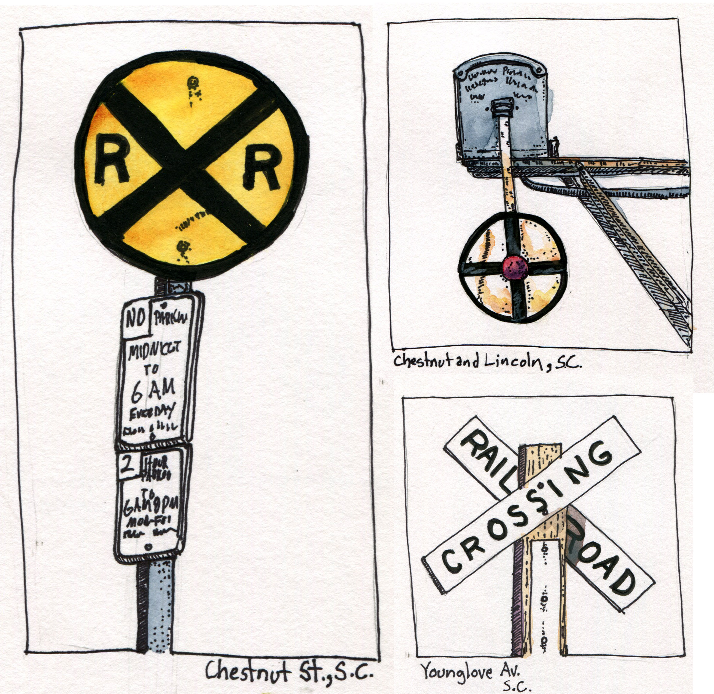
A grade crossing is where an automotive road crosses a railroad track (usually at 90 degrees). All crossings are required to have a least a sign or crossbuck, the “X” sign that reads “RAILROAD CROSSING”.
At heavily used roads and railroads, the crossing may have flashing lights with a warning bell and a gate. The grade crossing at Woodruff Lane in Marysville (featured sketch) has all the bells and whistles in grade crossings. No car wants to get in the way of a Union Pacific freight train.
In a later post about railroad semaphore, I noted that a freight train can take over a mile to come to a stop so if a car pulls in front of a train traveling at 55 miles an hour, even if the engineer applies the brakes, the car is toast.
With that in mind, a flashing, clanging, gated contraption makes a whole lot of sense.
And common sense tells us that when the warning lights are blinking or the safety arm is down, we should stop, no mater how much we may be in a hurry. It is odd that some motorist choose to ignore these warning signals and try to “beat” the train, usually with fatal consequences.
There are quite a few videos posted on youtube to demonstrate what happen when trucks and cars meet a fright train. Here is one such compilation:
You will never win with a game of chicken with a freight train.
A series on railroad grade crossing signs in Santa Cruz.The grade crossing on the UP line from Marysville to Oroville. The approach from the other side is blind hence the cantilevered signal to the left. This grade crossing has about everything to make it as safe as it can be.
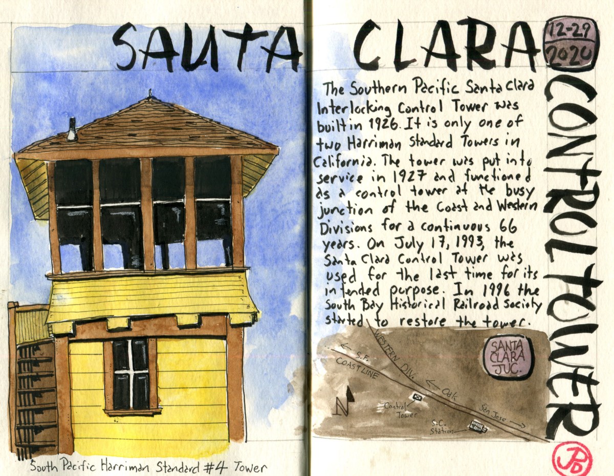
I have been sketching a few of the remaining Southern Pacific water towers in California but I had yet to add a control tower to my sketchbook.
There are about nine Southern Pacific interlocking control towers still in existence in California and 16 are still in existence on the former SP system. These control towers where once ubiquitous on America’s railroads at busy junctions or rail crossings. Interlocking control towers centralized a group of signals (semaphore and lights) that were controlled by an operator to control the rail traffic by communicating different orders: proceed, caution, or stop. Think of it like a traffic signal for trains.
The Santa Clara Southern Pacific Interlocking Control Tower was built by SP in 1926 and put into service in 1927. The tower was in continuous use for 66 years at this very busy junction of the Coast Line and the Western Division. In the 66 years of operation, many trains, both passenger and freight, passed by. The famed Coast Daylight sped by the tower, stopping to take on passengers in San Jose.
The tower was in use until July 17, 1993 when the control of all switches and signals were moved to a centralized control center in San Jose.
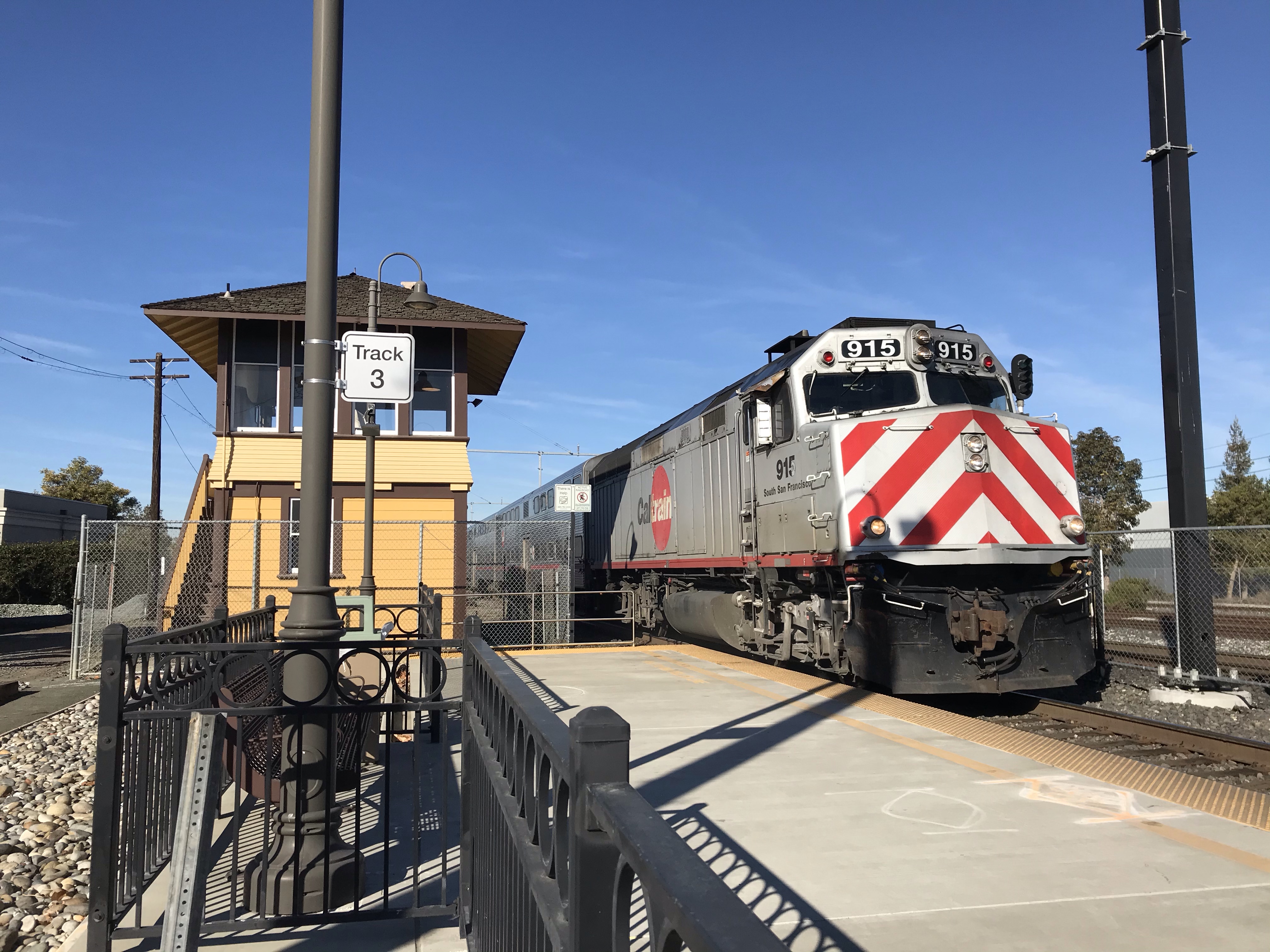
A Southbound Caltrain pulls into Santa Clara Station on its way to the end of its run in San Jose. To the left is the restored control tower. On point is locomotive 915 “South San Francisco”.
Santa Clara is a busy junction where the Coast Line and the Western Division meet. It is busy today with both passenger and freight traffic. The passenger trains that stop or pass this way are Caltrain, Capital Corridor, the Altamonte Corridor Express (ACE), and the Coast Starlight. Four main line track pass Santa Clara, tracks to the northeast are used by Union Pacific for freight. The other three train a primarily used for passenger service with some routes turning off here to head north, on the east side of the Bay, towards Oakland (the Western Division).
A northbound Caltrain passes the control tower as it pulls out of Santa Clara Station heading toward San Francisco. This consist is being pushed by locomotive 905 “Sunnyvale”, an EMD F40PH-2CAT.
Sketcher’s Folly: Oops I did it again. I made a sketching mistake. In my sketch of the California Theatre in Dunsmuir I left out an “I” and now I made the egregious mistake of misspelling the county of my birth: Santa Clara. What next? Misspelling my own name?! Well at least I’m making new mistakes!
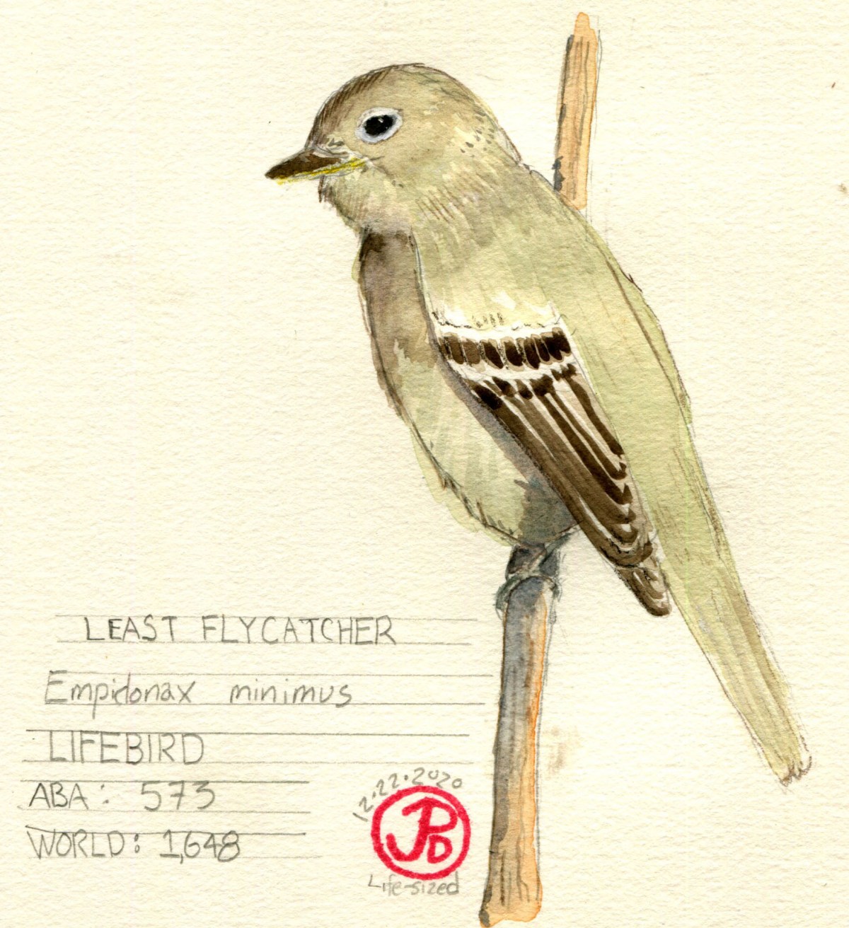
My world life list has been hovering around 1,647 species for a long time now. I was hoping to break 2,000 with a planned trip to Peru but of course it was canceled due to the global pandemic.
The pandemic also meant that I have not gotten out to bird across the country or the state as much as I would like. It is great to get out and be amongst nature looking at birds but sometimes when it is a rare species that has been reported, social distancing becomes a real issue as more and more birders show up to a certain site looking into the nearby bushes.
When I found out there was a least flycatcher being seen in the Presidio I rushed over hoping to get a glimpse of it before sunset. I whiffed on the flycatcher, missing it by about an hour. But I was determined to try again the following morning.
I was in place by quarter to nine the following day. I was soon joined by two other birders. A least flycatcher in California is a rare bird! This is a flycatcher that is normally found on the east coast and it is an Empid, a genus of small flycatcher that can be notoriously hard to distinguish from one another. Some call only be told apart by song.
Within the next hour birders reached critical mass at eight.
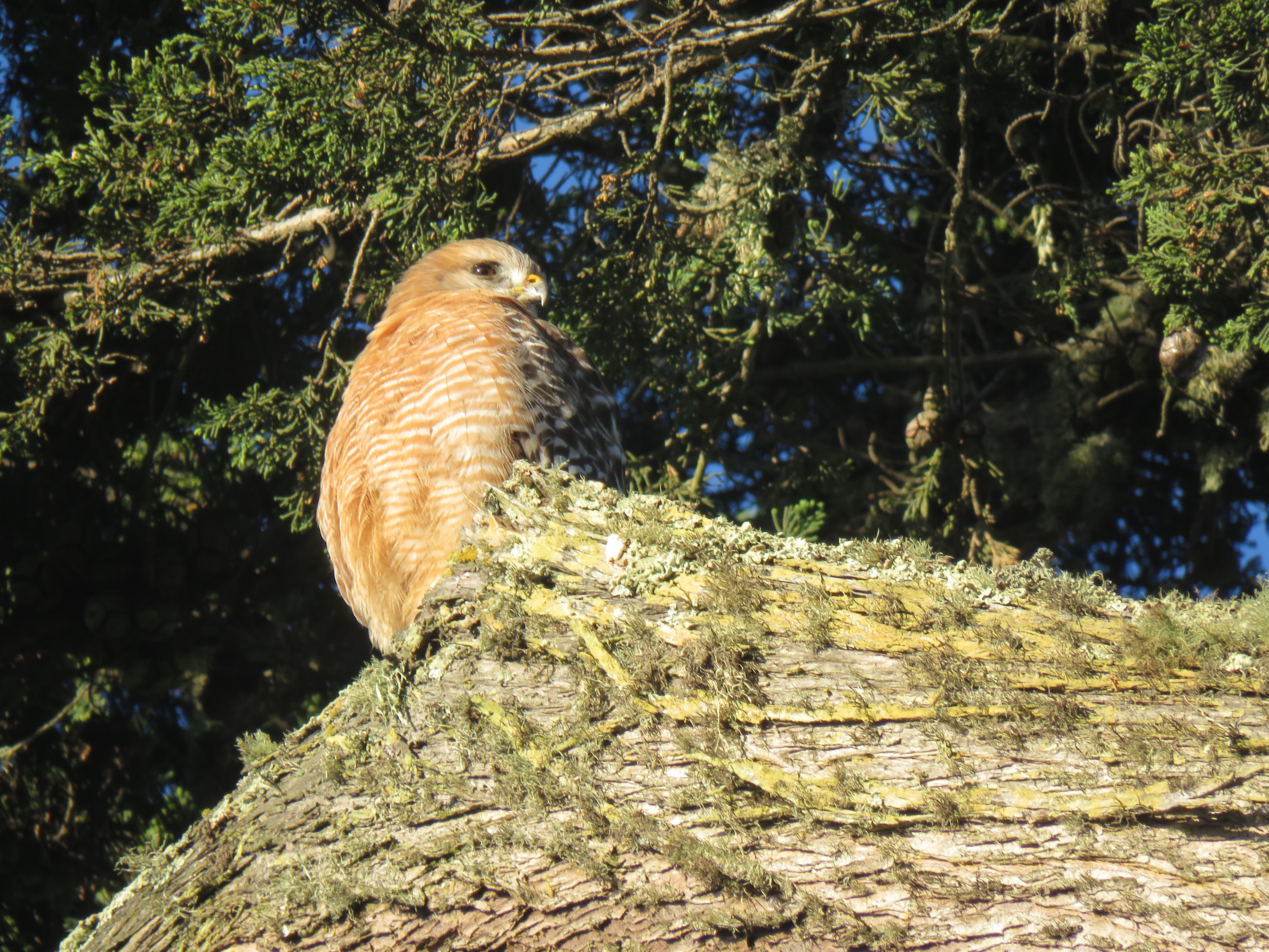
To pass the time there was plenty of passerine action and a few raptors too. A white-throated sparrow was foraging with golden and white-crowned sparrows. Another birder called attention to the continuing yellow-bellied sapsucker high in the eucalyptus trees. This woodpecker is considered rare in California. A stunning adult red-shouldered hawk was perched above, warming itself and preening in the morning light.
An Adult RSHA, squinting into the morning sun.
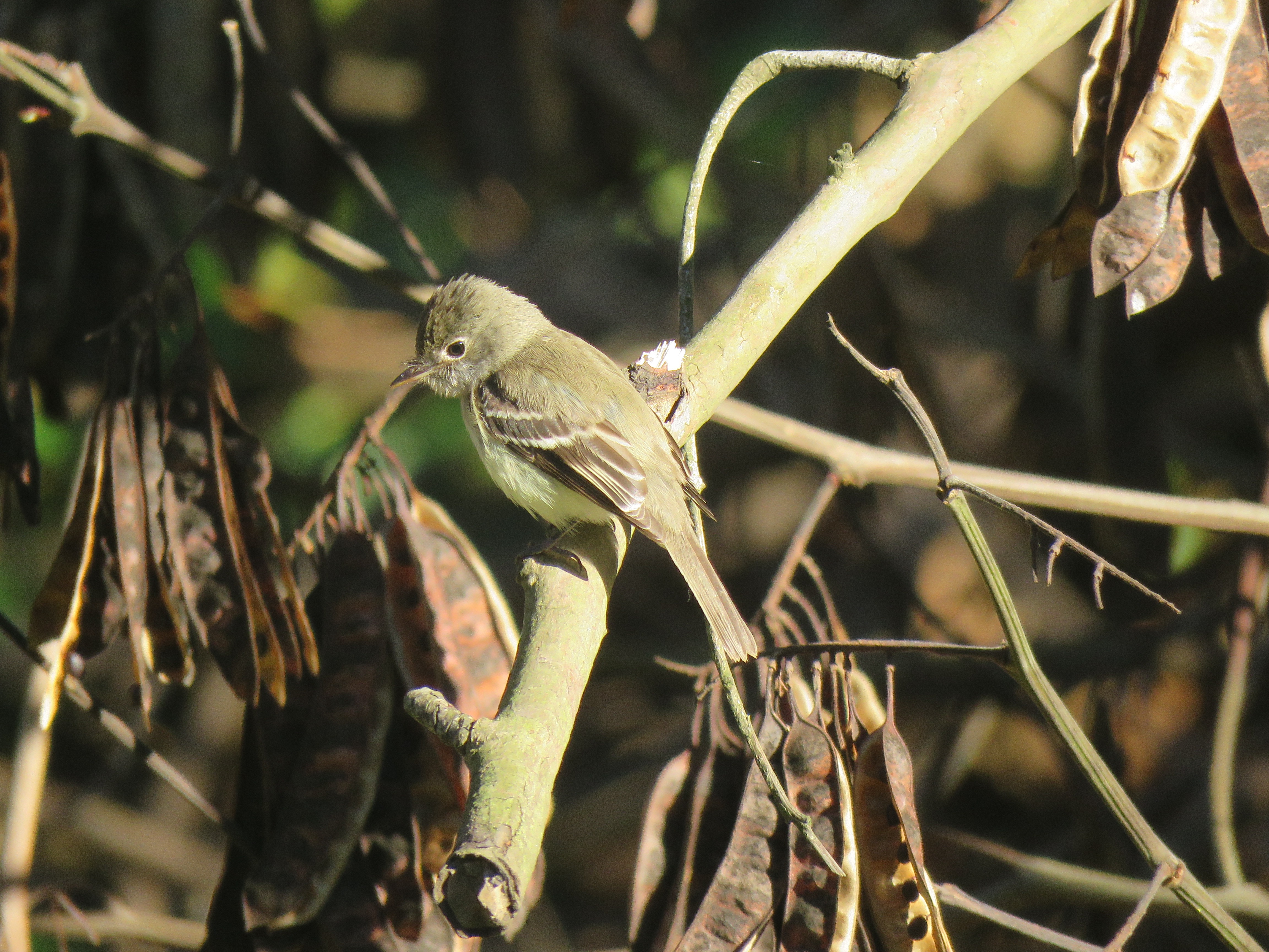
After an hour’s wait, by about 10 AM, a birder informed me that they had the flycatcher further down W. Pacific Ave. So I headed down and seven birders where looking into the forest edge. I followed their gaze and got on the least flycatcher!
This was a very active bird, hawking insects on the wings and occasionally landing on the ground to capture prey. The least flycatcher forages low to the ground, which can help with identification.
The diminutive least flycatcher, looking down for insects to catch.
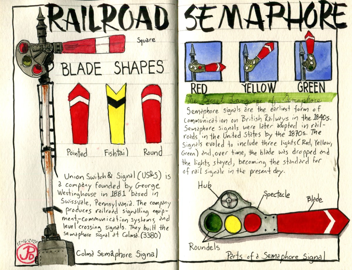
Semaphore is one of the earliest signal systems adopted by railways in England. It was and, in some cases, still is, used on railways around the world.
Semaphore went into wide use in England in the 1840s. Railroad semaphore is a signal that tells the engineer or engine driver that the line ahead is clear or whether the engineer should slow down or stop the train. This is an important safety device that prevents trains from colliding.
Trains, unlike cars, take a longer distance to stop. The average length of a freight train is between one to two miles and if that train is traveling at 55 miles per hour it would take about a mile or sometimes more (depending if the consist was empty or fully loaded) for the train to come to a complete stop. Therefore semaphore signals are essential to let the engineer know what dangers may lay down the tracks or around the bend.
These signals vary in design but they basically have a flag arm or blade that conveys a signal to an approaching train. The arm is positioned straight up, at a 45 degree angle, horizontal, or straight down. The blade is most often painted red with a white strip.
By the 1870s, the semaphore signal was in use by most railroads in the United States.
Later designs added signaling lights (red, yellow, green). Eventually the blade was dropped in favor of signaling lights alone. Now the majority of semaphore signals are gone on the rails of the United States’ main lines.
There still are a few semaphore signals in use in the United States such as on the BNSF’s Glorieta Subdivision in New Mexico. This route is still used by the Amtrak route the Southwest Chief (Chicago to Los Angeles).
The anchor for the sketch was a field sketch I did of the semaphore signal at the Colma History Museum. One of the things I really love about sketching is that you continually learn about the things you are sketching and just doing the sketch of the semaphore signal maybe made me wonder about its origins, designs, and its current status. The remainder of the spread is the byproduct of that wonder.
The layout of this spread has a satisfying and balanced feel. You have the high and low vertical elements of the semaphore signals in “stop” position and the use of triads. I would like to say that I planned this out by doing a pre sketch but this spread developed organically over time. The human eye, at least my human eye, likes repeated patterns and balance. And sometimes these designs happen without cognitive thought. It’s like each element of the sketch falls in place finding it’s own angle of repose.
A semaphore signal at the Colma History Museum. The signal is in the “Stop” position. Two semaphore signals in Niles Canyon near the Sunol Depot. This shows off two different styles of semaphore blades, square and fishtail.
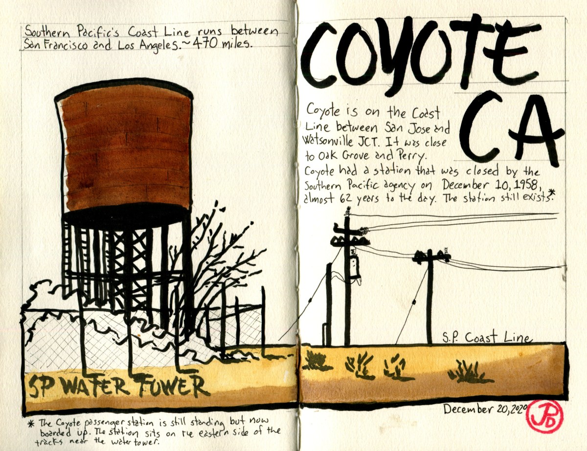
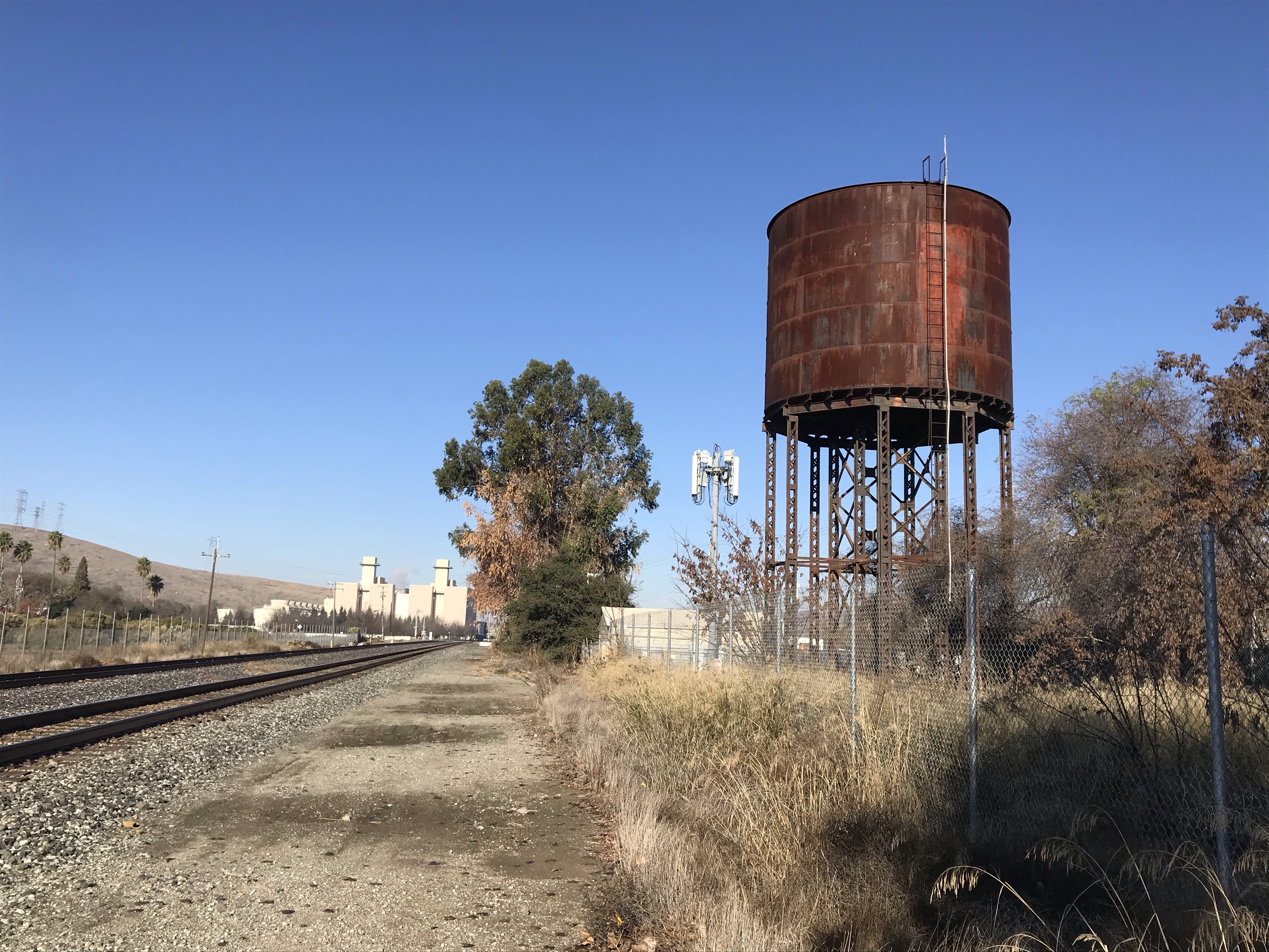
There are two Southern Pacific water towers remaining in the Bay Area, one in San Jose (near the passenger station) and one further south on the Coast Line in Coyote.
I headed to Santa Clara County, the county of my birth, to the Valley of Heart’s Delight (Silicon Valley). The small, blip of a town that is Coyote is south of San Jose and just north of Morgan Hill.
Coyote is on the Coast Line, a 470 mile route that connected San Francisco and Los Angeles. SP’s famous passenger service, the Coast Daylight, blew through Coyote. A resident of Coyote wishing to catch the Daylight to Los Angeles had to either head to San Jose or Salinas. Coyote has a passenger station that was in service until December 10, 1958. The building still exists but is now abandoned and boarded up. At one time it was a private residence.
The abandoned Southern Pacific water tower and the double tracks of the Coast Line on the left. To the left of the tracks is the Metcalf Energy Center.
Before heading down to Coyote I stopped off at the town where I grew up: Sunnyvale. As I exited off Highway 280 and headed north on Sunnyvale Saratoga Road, I reflected, as I always do when I’m in Sunnyvale, on how much it has changed from the 20 odd years I spent here.
Along the road, there were things that where very much the same, such as the Longhorn Restaurant on the right (I don’t think I every ate here), and to the left is Fremont High School. The 1925 main building looks very much the same but according to a family friend, who is an assistant principal at Fremont, a lot of renovations are happening on campus.
The reason I turned off the highway was to see another water tower in the South Bay. This tower was not built by Southern Pacific, although it sits just north of the Coast Line. Before Silicon Valley, this area was known as the Valley of the Heart’s Delight and the valley was covered in apricot and cherry orchards.
According to the Sunnyvale orchardist, Charlie Olson, there used too be “eight to nine million” fruit trees in Sunnyvale. Now there are eight to nine hundred.
To process all the fruit, canneries where built along the railroad line. My father, after coming home from work, would put me one the back of his bike and he would ride on the same route he had just come from. He spent his working career at Westinghouse which was also right next to railroad.
During the harvest season, a favorite destination was a pedestrian bridge over the railroad. From this vantage point we could watch commuter trains come and go and also we could look down into the yard of one of the canneries. Here forklifts moved at a frenetic pace and I can still recall the persistent din of the processing plant as workers canned ripe fruit to be shipped, by rail, to the nation. At this time, in the mid to late 1970s, Sunnyvale very much had one foot in the agricultural word.
This cannery was the former Schuckls Cannery which was later bought by California Canners and Growers in 1963. It was in operation until the cannery was demolished in 1984. The year 1984 was a auspicious year in the valley, it was in this year that Apple introduced the Macintosh computer.
This was about to change as the valley and it’s orchards were slowly replaced by Silicon Valley. It is interesting that one of the valley’s sons recognized the beauty of this area but was also one of the catalysts for it’s demise. Steve Jobs, the co-founder of Apple, said, “Silicon Valley for the most part at that time was still orchards-apricot orchards and prune orchards-and it was really paradise.”
Can we say that Sunnyvale is now a paradise? Well I guess it depends on how you define “paradise’.
As I crossed over the railroad tracks as South Matilda Ave. become North Matilda, the water tower came into view.
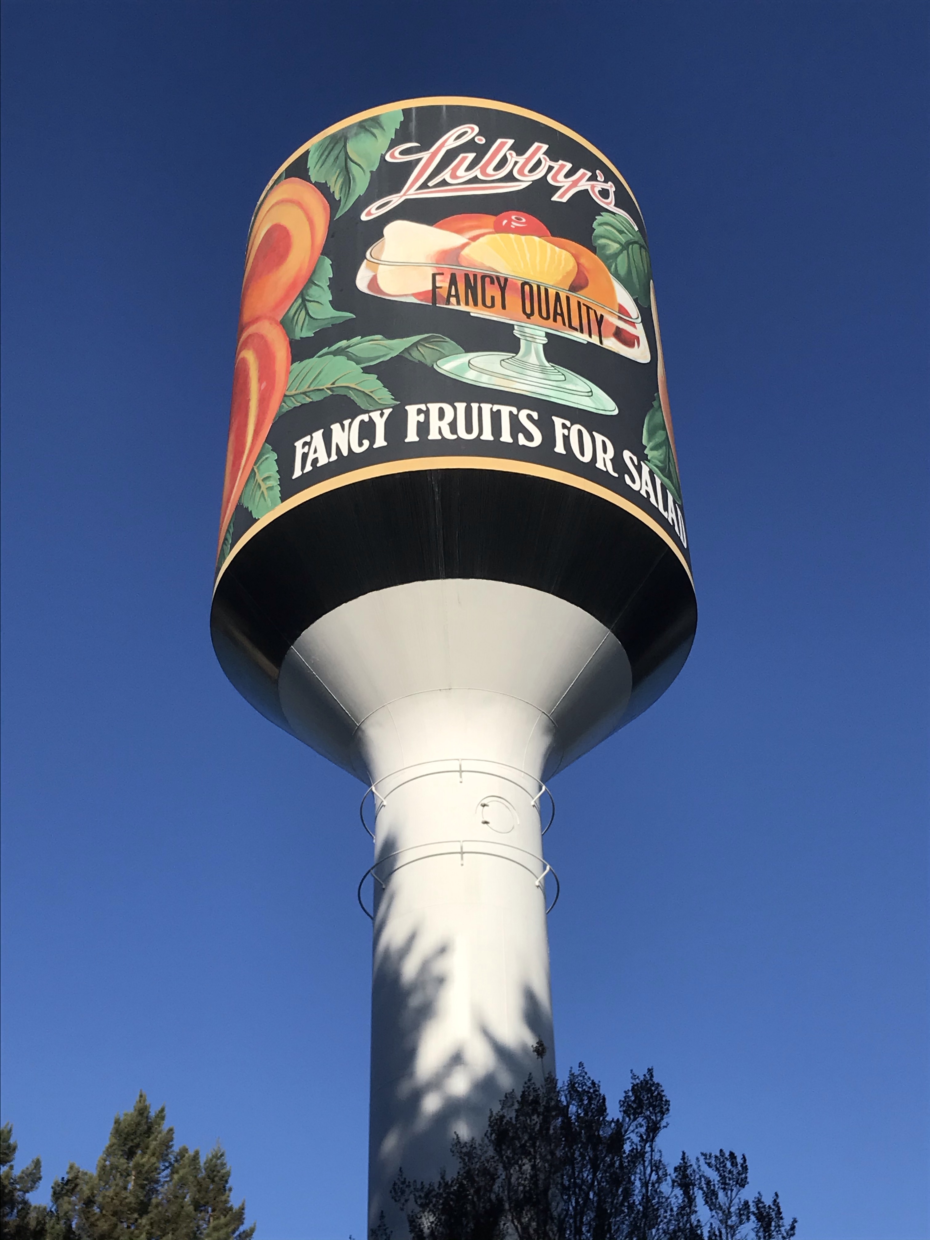
The Libby Water Tower is all that remains of the largest cannery in Sunnyvale. Libby, McNeill and Libby opened it cannery in 1907 and by 1922, it was the largest cannery in the world.
The current water tower was built in 1965 and is shaped like a can of Libby’s Fruit Cocktail. This is all that remains of one of the biggest canneries in the valley. It is now surrounded by a business park with buildings occupied by Walmart and Raytheon.
Looking up at this water tower I can recall the sounds of the cannery working at full capacity, to can the bounty of the Valley of Heart’s Delight.
The Libby Water Tower in Sunnyvale. It has been repainted as a can of Libby’s “Fancy Fruit for Salads”.
I planned to sketched the water tower at Black Butte, in the shadow of Mt. Shasta in Northern California.
I wanted to sketch this Southern Pacific water tower because of it’s historical significance and also because this is one of the few water towers still in operation as Union Pacific (it’s current owner) keeps this active to water any of UP’s heritage steam engines and other steam excursions that might pass this way. (SP 4449 topped up her tank here in the summer of 1991). The tower was built in 1926.
But not all plans come to fruition. I headed up to Weed to sketch the water tower only to find that the road leading to it was gated and all the signs around the area read “No Trespassing, Do Not Enter”. This area was still very much an active Class I railroad and I’m sure UP didn’t appreciated railroad gawkers and sketchers near their tracks.
So in order not to become a headline in the local paper, I chose to turn back towards Dunsmuir.
Steam engines cannot function without water. If water runs too low in the boiler it can result in a deadly boiler explosion. Therefore railroads built water tanks or towers near railroads, spaced out so there would be water along the line, when the locomotive became “thirsty”.
But I still wanted to sketch a more accessible Southern Pacific water tower so I did some research. I found that in the State of California, there are 16 Southern Pacific water towers still in existence. While I was not able to access one of those, there were still 15 left to find.
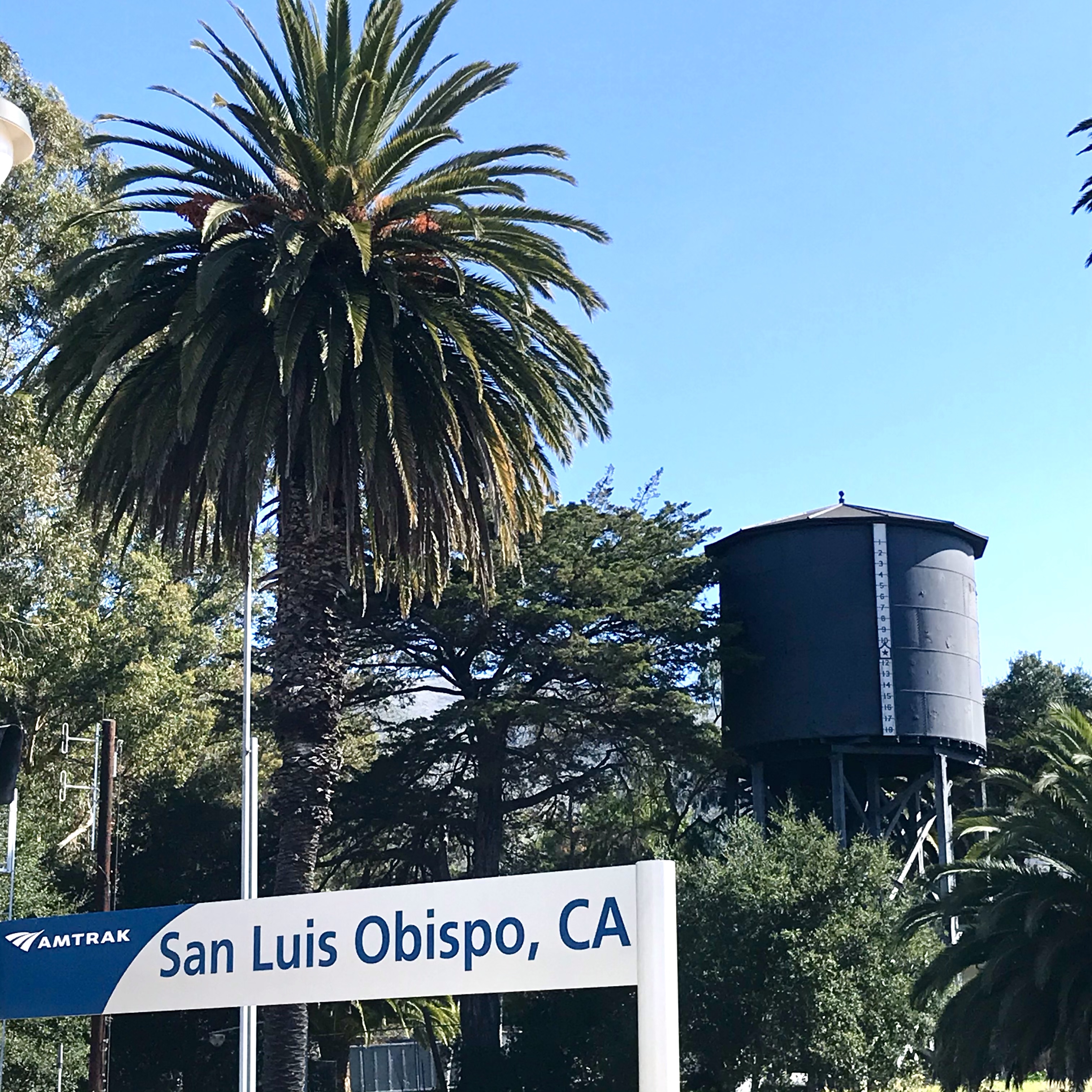
I hade seen the 65,000 gallon restored water tower across from the passenger station in San Luis Obispo. It was built in 1940 and was retired in 1956. I did have it on my sketch list but I didn’t get to it. One down, fifteen to go.
The restored Southern Pacific water tower in San Luis Obispo. This tower was slated to be torn down but local interests intervened and saved it from destruction.
I set my sights on the Southern Pacific water tower in the small Solano County town of Elmira (population 188).
Elmira was a major railroad stop in the early part of the 20th century as it was on the Cal-P line between Vallejo and Sacramento. At Elmira, there was a spur that went to Vacaville, Winters, and Rumsey as part of the Vaca Valley and Clear Lake Railroad. It is easy to understand why a water tower was built here because of the rail traffic and the spur.
Then U.S. Route 40 (now Interstate 80) was created as one the the first Interstate Highways in 1926. It was the first major east-west route, starting in Atlantic City, New Jersey and terminating in San Francisco. The route passed west of Elmira, through the town of Vacaville. Since that time the town of Elmira never recovered. As the population and development in Vacaville grew, the town of Elmira became a rural backwater with a shrinking population.
The same growth in the Nation’s Interstate Highway system also was the death knell for many railroads across the country with trucks and cars replacing freight and passenger service.
The last freight train to run on the spur to Vacaville was in 1985. After that the rails between Vacaville and Elmira were abandoned and then later removed.
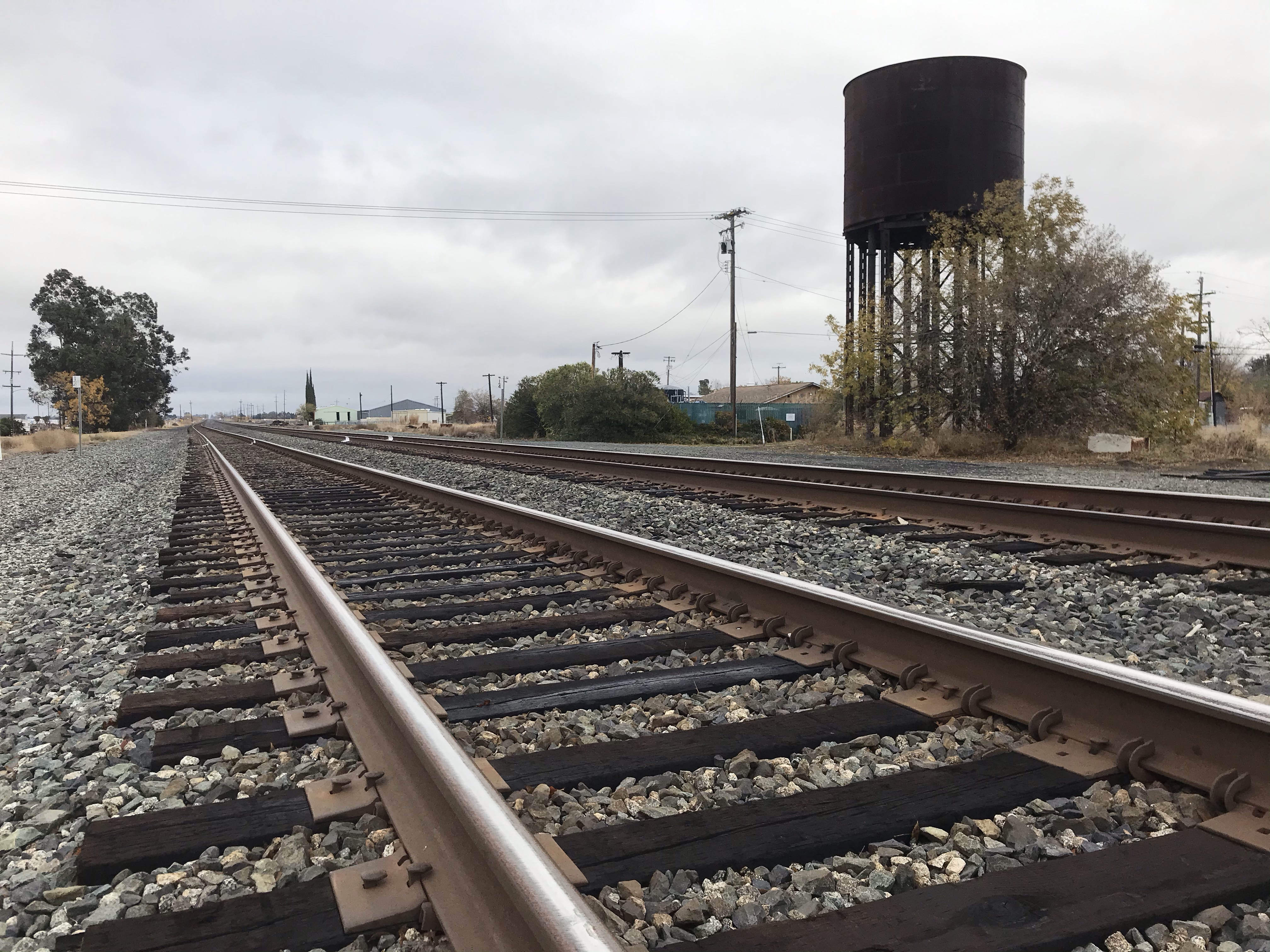
The abandoned but still standing Southern Pacific water tower at Elmira. The tower is not fenced in and there are no historic signs about the tank. It looks to be similar to the 65,000 gallon tower in San Luis Obispo and I imagine that it was built in the 1930s or 40s and used up until the mid 1950s.
The passenger station is now gone but active double tracks still pass the abandoned and rusted water tower at Elmira. The Capital Corridor passenger service runs 16 trains every weekday. The 168 mile service runs from San Jose to the state capital in Sacramento. A few trains head further north to Auburn.
Looking north towards Davis and Sacramento. Two sets of polished tracks pass through Elmira. These rails get lots of use with 16 passenger trains on a normal weekday.Westbound train number 729 passes by Elmira’s water tower at 9:28 AM on a Saturday morning at a rapid clip. There is no longer a passenger station in Elmira. The closest station is to the south at the Fairfield-Vacaville Station. On point is an EMD F59PHI with “California styling”.
In Dunsmuir, I stayed in two different cabooses at the Railroad Park Resort. These cabooses had last seen service as the conductor’s mobile office over 40 years ago.
They now served a purpose in which their builders had never envisioned. A hotel room on wheels with bed, bath, and television.
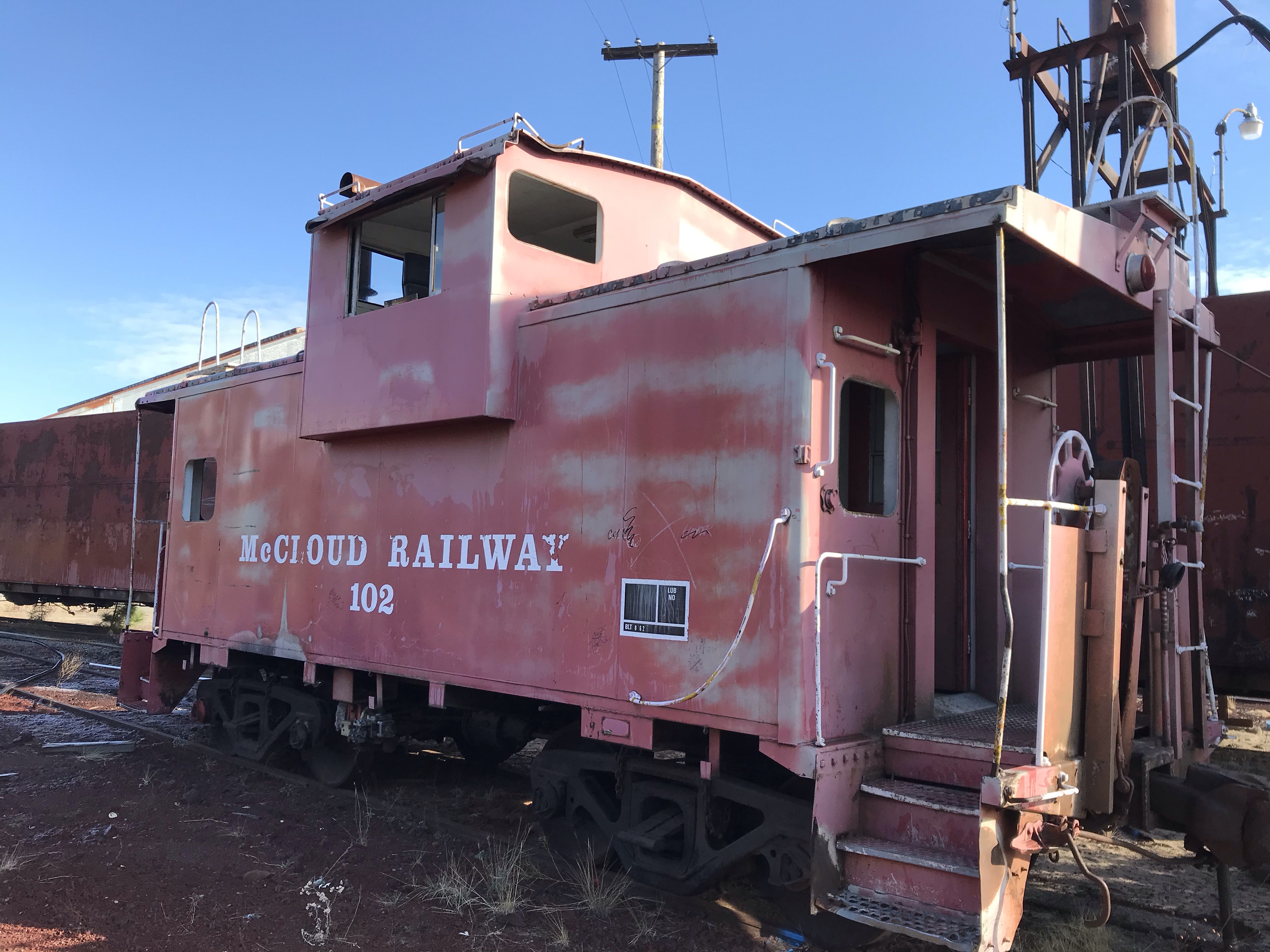
When I wandered into the yard of the defunct McCloud Railroad, I was excited to see two working cabooses. These where not the repainted and refurbished cabooses that can be seen throughout the land as part of restaurants, static displays, or hotel rooms. These cabooses were the workhorses of the McCloud Railroad. They may not look sexy in their peeling paint and their faded logos but they are the real deal.
McCloud cabooses number 101 and 102 are steel custom International wide-vision types, especially built short for the railroad in 1962.
The caboose is at the end of a freight train just as they are at the end of their own railroad journey.
Seeing these rusted and damaged cabooses (101 was damaged in a yard accident in 1997) proved to be a strong metaphor for the end of the McCloud Railroad and by extension, most smaller railroads across the nation.
The McCloud yard, in the shadow of Mt. Shasta, is now a quiet and static place. No more are heard the sounds of the steam whistle, or the deep boom of a diesel. No more are heard the screech of freight cars over rails and the smell of hot brake pads.
But I returned again to look at the two remaining cabooses. A former shell of their working life. The McCloud River Railroad logo, fading away, to eventually match the rusty-orange of the caboose.
Number 102 was sitting by itself to right of the shop building next to a snow spreader 1850 “Wing and a Prayer”. I walked across the yard to the tracks that veered off to the right, which I assume lead to the east towards Bartle and the junction to Burney.
On this track was a strange consist of passenger cars that now sport a coat of graffiti and most of their windows had been smashed in. Sandwiched between these cars were a hopper car and a crane car. At the end of this motley collection of cars was McCloud River Railroad Caboose #101. The caboose was coupled to the last passenger car, as if ready for the train to leave the yard on rails that abruptly turned to red, volcanic dirt.
The McCloud logo was designed by school children. It was adopted as the companies logo just as the railroad headed into the diesel era.Caboose # 102 sitting in the McCloud yard. This caboose was used much later that # 101 and bears the name McCloud Railway.
Mt. Shasta dominates the landscape for miles around.
When you are on Highway 5 in Northern California. Mt. Shasta is a beacon. This perpetual snow covered mountain has a long geologic and human history. In the Native Karuk language they named this mountain “White Mountain”.
At 14,162 feet Mt. Shasta is the tallest mountain in this part of the southern Cascade Range.
Because Mt. Shasta seems always to be within eyesight, when in this part of the Golden State, it seemed that I had to sketch it. The tough decision was from what of the infinite perspectives would I sketch the mountain.
I drove around Shasta City and there were many great perspectives but some marred by buildings or power lines so I headed out to the sticks: Lake Siskiyou.
I found some good views from the shoreline but they would have been better it I was on a boat in the middle of the lake or on that far shoreline if I could only figure out how to get there.
I didn’t find what I was looking for so I continued on driving around the lake, which is really a reservoir made by damming the Sacramento River. I thought the road I was on was going to circle around the lake but at one point it started to head away from Lake Siskiyou. I pulled over and I looked back from where I came and I realized that I had found my sketching perspective! Behind me, Shasta rose above the forested, foreground hills.
I pulled out my sketching stool and gear and had a pleasant encounter sketching Shasta by the side of the road with the two ravens and the stream beside as my companions.
The logo for the McCloud River Railroad was designed by school children in a contest. It features a bear balanced on a log with a fish. And behind is the ever present Mt. Shasta. Mt. Shasta in the background and the McCloud Railroad in the foreground. This is near the point where the railroad joins the Union Pacific mainline in the appropriately named Shasta City.
I wanted to add another night to stay at the Railroad Park Resort in Dunsmuir but the SP Caboose # 17 was booked, so I booked one of the popular Santa Fe cabooses.
I spent my last night at the Resort in Caboose # 28 a former Santa Fe cupola caboose.
This CE-2 caboose was built by the Atchison, Topeka & Santa Fe railway in 1942. It was rebuilt in 1970 and renumbered as ATSF 999448. It came to the resort in the late 1980’s.
A caboose is a uniquely bit of United States railroading. At one time all freight trains had a caboose (usually red) at the end of each train. A caboose came at the time when train crews were larger than they are today, during the age of steam. Each locomotive had an engineer and fireman but the conductor was in charge of the train. The conductor’s office was on rails, this was the caboose.
From the caboose, the conductor could throw switches, aid in backing up, check the train for safety, and fill out paperwork. From the view in the cupola, or later the bay window, he could oversee the train to make sure no loads were shifting on freight cars. He could also monitor the train for overheated axels called “hot boxes”.
Most cabooses where fitted with a desk, bathroom, bed, and storage closets. It really was a home-office on wheels, reflecting the long work days and may miles on the railroad.
Laws where in place that all freight train had to contain a caboose for safety reasons. This changed as technology improved and railroad cuts made more with smaller crews. The new, modern diesel-electric engines had larger cabs which means that the conductor could ride up front.
The technology railroads use to replace cabooses are called an end-of-train device. These devices are fitted to the last car of a freight train and monitors air brake pressure and over heated axels. There is also a blinking safely light that warns other trains behind..
By the early 1980’s, laws were changing that no longer required trains to have cabooses. By the mid-1980’s most freight trains no longer ended with a caboose. The era of the red, cupolaed caboose was over.
Whenever I watch a long freight train pass by, I hopefully expect to find a caboose at the end of the train. This comes from seeing so many cabooses on freight trains when I was a young rail fan. In my mind, some how, the blinking, oblong box at the end of a train will never really replace a caboose
This 1972 built Southern Pacific bay window caboose, #1886, was one of the last cabooses in service on the railroad. It was last in service on November 15, 1995 on Southern Pacific’s Lompoc White Hills branch line. I was told the reason for this was that there was a part of the line where the train had to back over a road crossing and the caboose was required for safety reasons. It is now restored and on exhibit at the San Luis Obispo Railroad Museum.
At one time it was a company town for the Southern Pacific Railroad when 3,000 of it’s citizen’s where employed by Southern Pacific Railroad.
Dunsmuir was previously known as Pusher because this is where helper locomotives where either added or taken off trains. They were put on to make it up the Cantara Loop and the climb out of Dunsmuir as the line headed north. Helpers where also used on downslope freight trains to help with dynamic braking.
The town contains a railyard, shops, and a still functioning turntable to turn locomotives around. In it’s heyday, Dunsmuir had a population of 5,000, many of those working for the railroad, serving the labor intensive steam locomotives. When the stream locomotives were replaced by more efficient disel-electric locomotives, the town’s population was almost halved.
Today, the mainline sees two passenger trains and about 15 freight train daily. Most freight trains are now powered by three to four, 4,000 to 6,000 horsepower, diesel-electic engines, so the need to add engines has become obsolete.
Dunsmuir still feels very much like a train town even though Southern Pacific was aquired by Union Pacific in 1996.
The main street, Dunsmuir Avenue, is beautiful in it’s small town charm. And of course the main street parallels the main line.
The crown jewel of downtown Dunsmuir is the California Theatre. This 800 seat movie palace was opened in 1926. The theater featured a stage and a Wurlitzer pipe organ. The theater is only one block from the passenger station and, in it’s heyday, many of Hollywood’s finest and other dignataries visited the theater including Babe Ruth, the Marx Brothers, and Clark Gable.
In recent times the theater has faced some troubling times, after many stops and starts the theater closed in 2016. There was also a Masonic Lodge that met in the building for close to 70 years.
I parked on Dunsmuir Avenue and did a car sketch (great for social distancing) of the the epic sign and marque. I added a bit of artistic license when I added perhaps the best movie ever made featuring a locomotive, Buster Keaton’s masterpiece, The General (1926).
Across from the station is a mural on an oil tank. The mural was created by rail historian, artist, author, and former employee of the Southern Pacific and McCloud Railroad, John Signor. This is a sketch I did from my photograph. It features a Southern Pacific EMD SD45 T-2R diesel-electric locomotive and the famous Daylight GS-4, 4449. This mural represented the future and the past of the Southern Pacific Railroad. It is also a reminder of the name of the railroad that built Dunsmuir.Only two passages trains stop at Dunsmuir Station. The north and southbound Coast Starlight, an Amtrak service from Seattle, Washington to Los Angeles, California. To catch the Coast Starlight at Dunsmuir, you have to get up very early in the morning (or simply just stay up). The southbound Train 11 arrives in Dunsmuir at 12:35 AM and northbound Train 14 arrives at 4:56 AM!Dunsmuir is an important division point in the Shasta Division where train crews change over. In this case, a BNSF freight train with a consist of hopper cars, change it’s engineer and conductor. BNSF is granted trackage rights to use this route by the tracks owner: Union Pacific.
Note: Part of sketching, and life I might add, is making mistakes and with this sketch I made one. I am a native Californian and I made unforgivable mistake of misspelling my own state! That sometimes happens when you are so focused on form and not spelling. I added the missing “I” on the street below.