Image

The Johnston Ridge Observatory

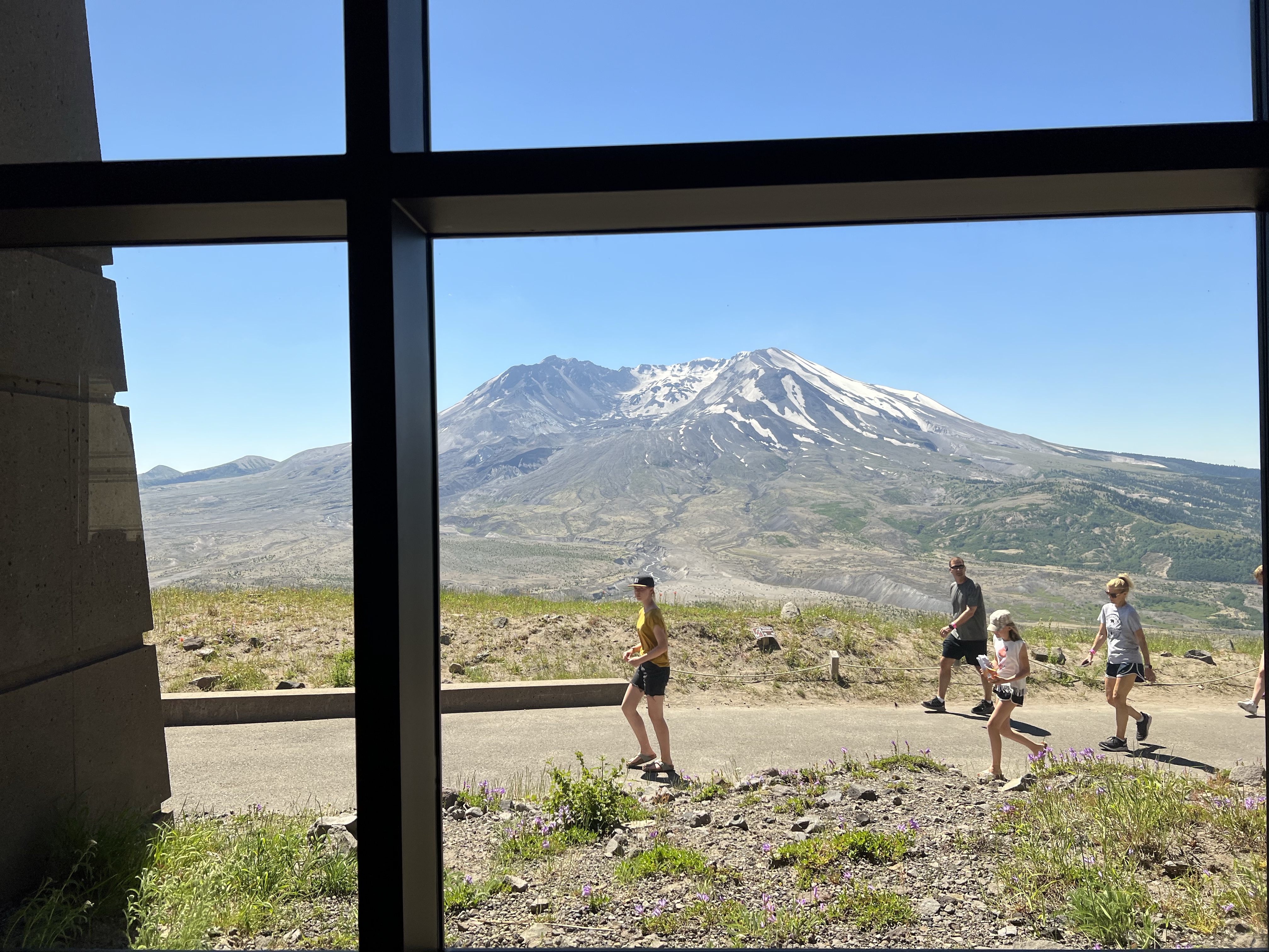
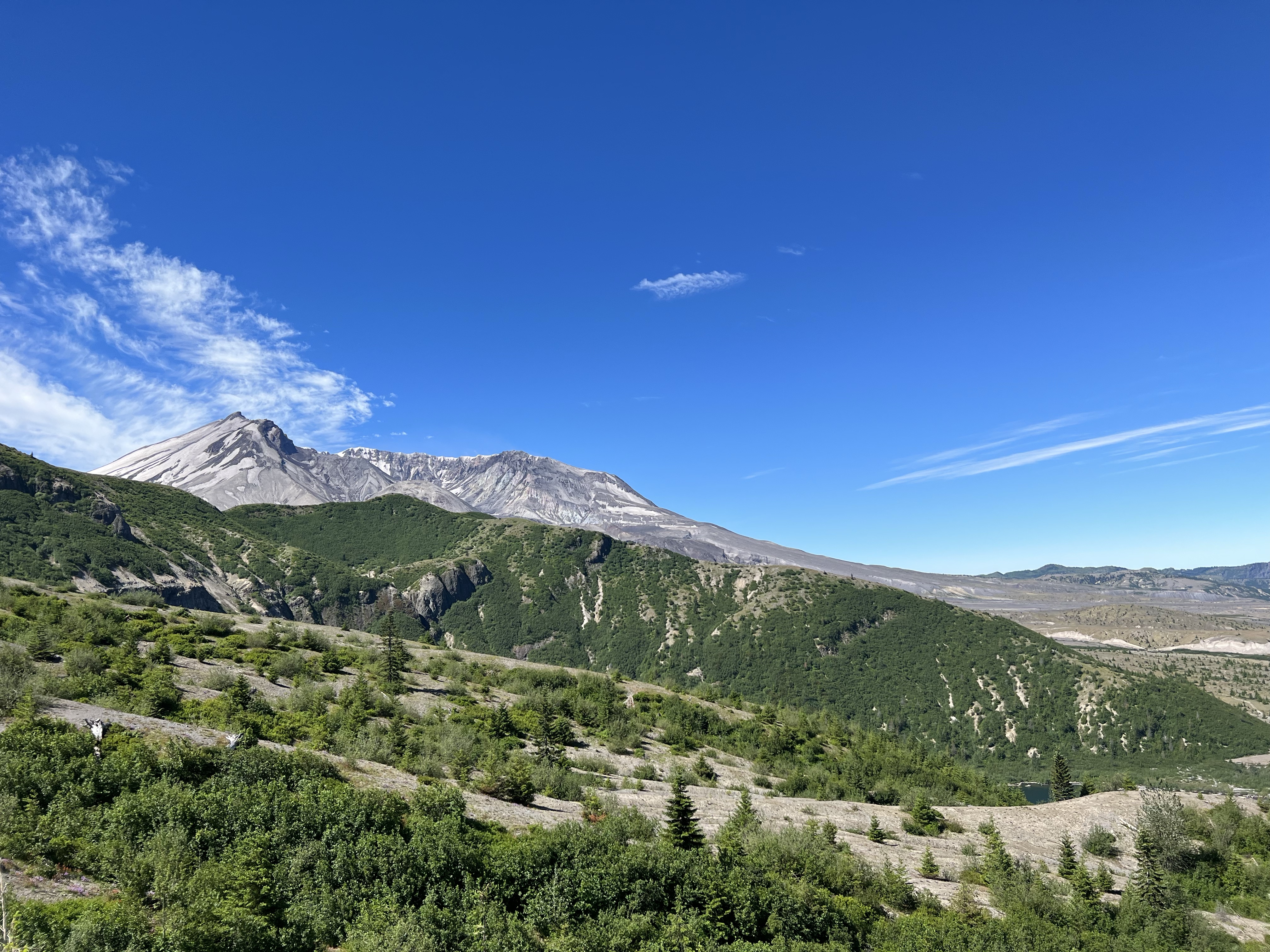
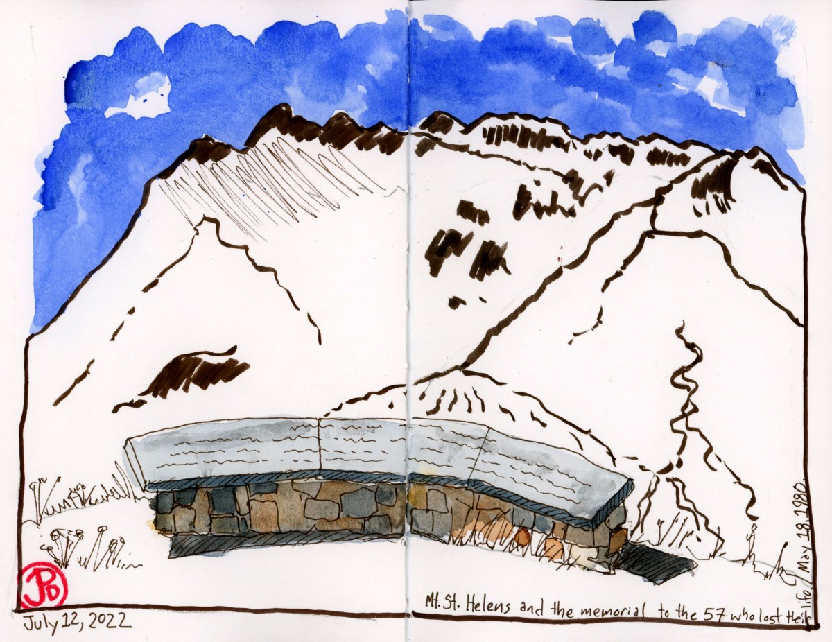
Most visitors who want to get close to Mount St. Helens, drive the 48 miles on the Spirit Lake Highway to the Johnston Ridge Observatory.

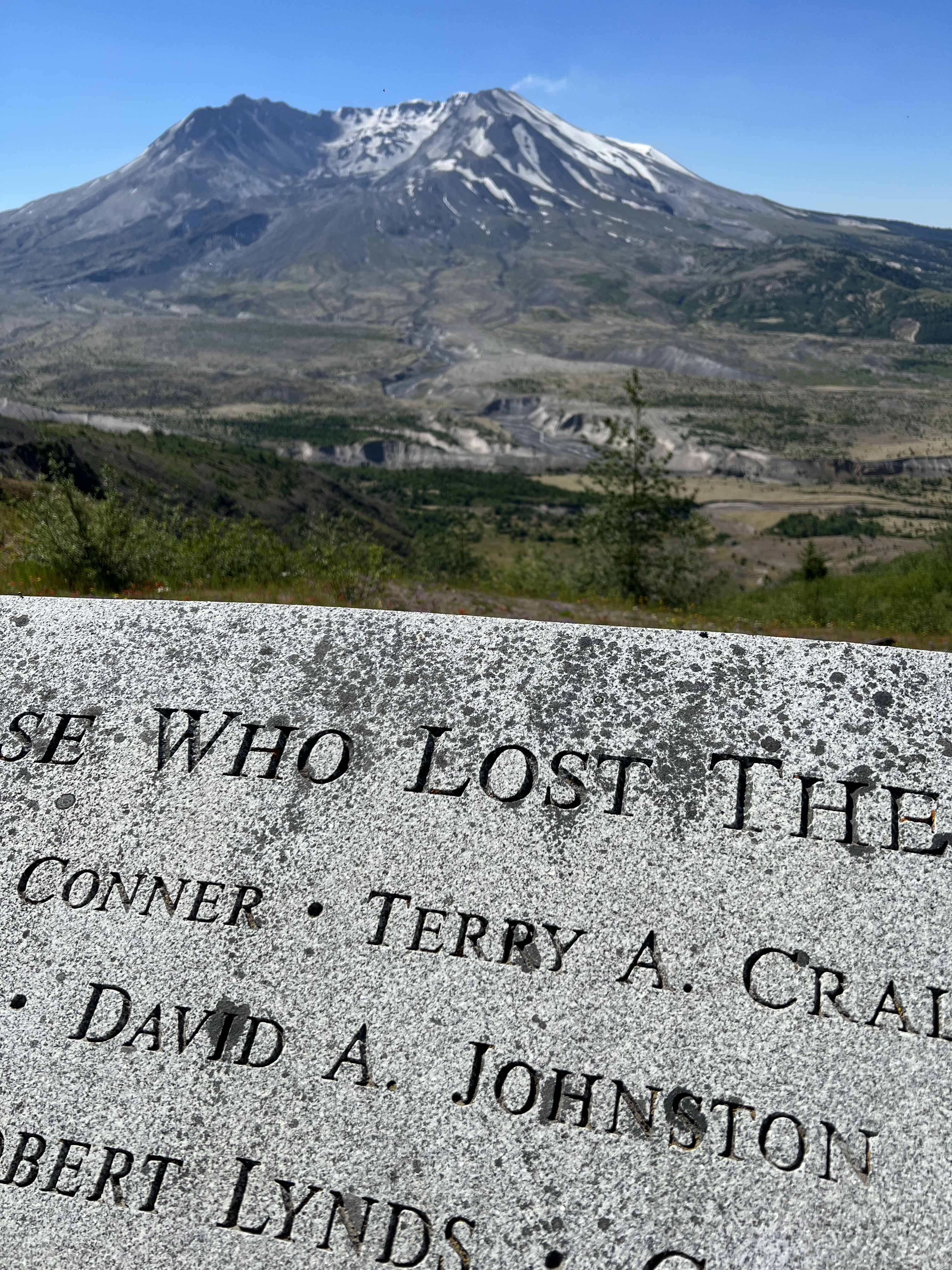
Here you are a mere 5.5 miles from an active volcano. This is well within the former Red Zone which was restricted to visitors in the winter and spring of 1980. Only certain people where allowed into the Red Zone and one of those was David Johnston, a volcanologist, who was there to monitor the volcano.

Johnston was really not supposed to be there the morning of May 18 but out of kindness he switched shifts with a colleague who was busy meeting with some foreign graduate students.

At the time of the eruption, Johnston was 30 years old and he had been working as an volcanologist who specialized in the study of volcanic gases and how these gases might help in the prediction of volcanic eruptions. He was at Mount St. Helens as one of the many scientists that were here to help monitor the volcano and to carefully watch the bulge on the north side of the mountain that was growing by five feet a day.

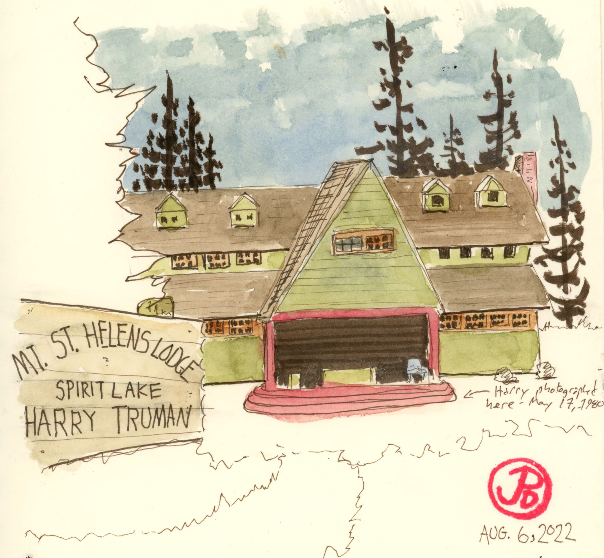
On Saturday May 17, Johnston stationed himself outside a USGS RV at a location called Coldwater II, 5.5 miles from the volcano. On the following morning Johnston made some measurements and observations and then at 8:32 AM, he radioed the USGS headquarters in Vancouver, Washington: “Vancouver, Vancouver, this is it!”

This field sketch is from the approximate position of Coldwater II, the observation position of David Johnston on May 18, 1980.

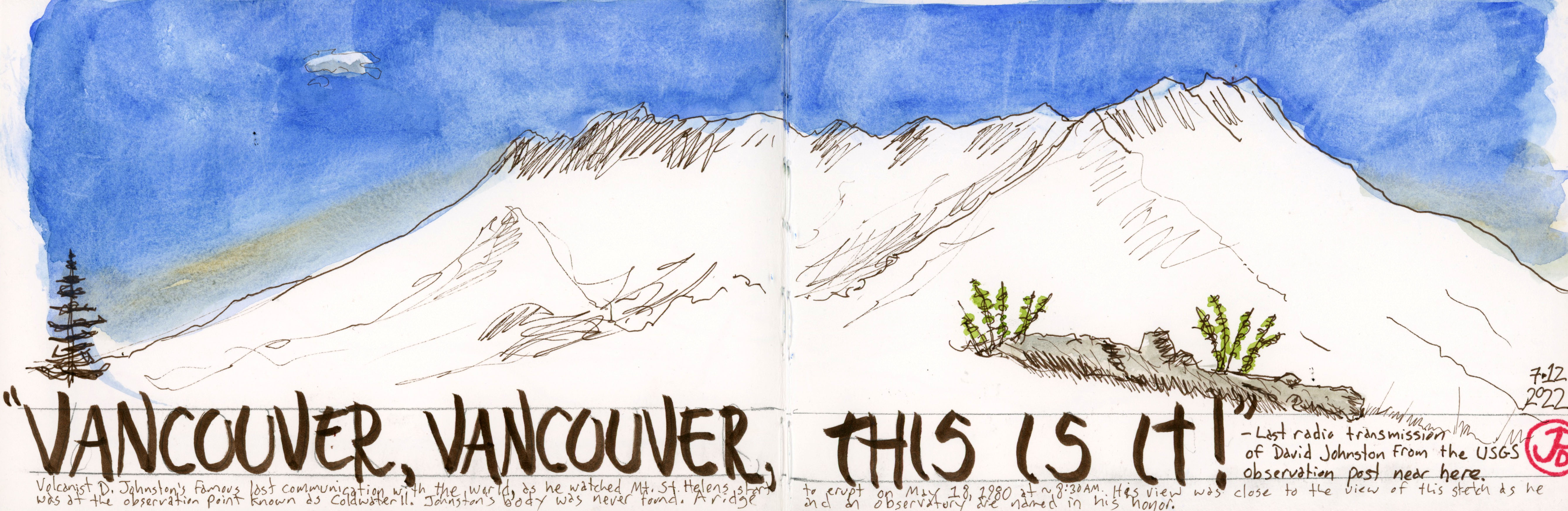
This was the last radio transmission from Johnston.

At 8:32 AM there was a 5.1 magnitude earthquake under the volcano causing the north face to fall away from the mountain causing the largest landslide in recorded geologic history. The avalanche travelled 14 miles before coming to a rest. This uncovered the over-pressured core of the volcano, releasing ash, magma, and rocks, fifteen miles into the atmosphere. The eruption of Mount St. Helens was now underway.

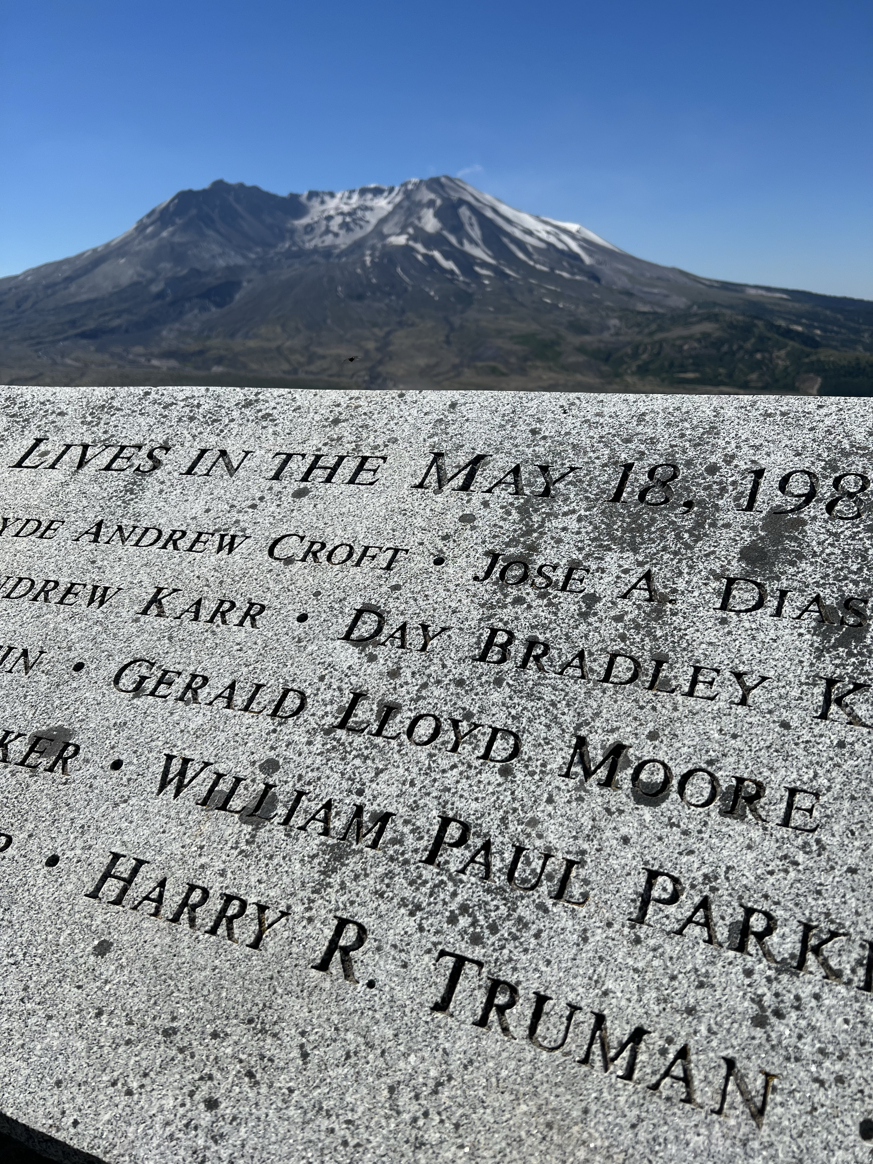
Johnston’s body was never found. The ridge where he was on that fateful day in 1980 is now named after him.

The memorial to the 57 who lost their lives and it’s cause in the background. David A. Johnston is one of them. The memorial is a short hike from the Johnston Ridge Observatory and it is this viewpoint that is in the featured sketch.
The incredible vista of Mount St. Helens from the Johnston Ridge Observatory.
Image

The Spruce Goose

When we think of an eccentric billionaire we tend to think of Elon Musk, but for decades before, the poster child for the archetype was Howard Hughes.

Musk and Hughes both shared an interest in aviation and exploration, and both went big. Hughes went really big.

I deviated off Highway 5 to see one of Hughes’ biggest follies. I was traveling to the town of McMinnville, Oregon (pop. 34,000), while it is only about an hour from Portland, the town seemed to be in the middle of nowhere and an unlikely location for housing the largest seaplane in the world.

This seaplane, coined the “Spruce Goose” (a nickname that Hughes always hated), is now housed in the Evergreen Aviation & Space Museum. It was nicknamed the Spruce Goose because it is the largest wooden airplane ever built. It also was given the moniker, The Flying Lumberyard, a name I think Hughes also hated.

The massive seaplane was designed during World War II as a cargo plane to ship goods across the Atlantic Ocean while avoiding the attention of German U-boats. The Spruce Goose only flew once, on November 2, 1947 in Long Beach, California. The plane was only airborne at a maximum height of 70 feet for 26 seconds. By the time of this test fight, the war was over and the plane was no longer needed.

The plane went into storage and was keep in pristine condition by a crew of 300 that were on Hughes’ payroll. They were sworn to secrecy and the aircraft was kept in flying condition but the Spruce Goose never flew again. In 1962, the crew was reduced to a fraction of it’s size and then was disbanded on Hughes death in 1976.

For many years the Spruce Goose (officially known as the Hughes H-4 Hercules) was displayed in a dome called the Spruce Goose Dome in Long Beach, California from 1980 to 1992. The new owners of the dome (a small company named Disney) felt that the oversized airplane was not making them enough money so a search was made for a new home for the massive airplane.

The new home was found in Oregon and the Spruce Goose was disassembled and shipped by barge, train, and truck and after a 138 day and 1,055 mile journey, the longest distance the H-4 ever travelled, the Goose arrived in McMinnville, Oregon.

The Spruce Goose is so massive that the museum was built around the plane and it upstages all the other aircraft on display beneath it’s massive wings. Sketching the H-4 proved to be a real challenge because you cannot get far enough away from the plane to capture it in it’s entirety. So I had to sketch it in pieces: the front (featured sketch) and the tail.

I could barely get three of the eight engines into one photo of the Spruce Goose. This airplane is massive!

Image

The Panorama From Windy Ridge

Perhaps the best view of Mount St. Helens, takes the longest drive, but the payoff is worth it.

This is Windy Ridge, five miles from the crater of Mount St. Helens. From the viewpoint you can see the U shaped peak of the volcano to the left and Sprit Lake to the right. Everything before you was part of the devastation zone.

All these year later the Pumice Plain still looks like a moonscape and Spirit Lake still has a raft of fallen logs that travels around the lake with the wind.

The matte of logs, looking here like toothpicks, from the 1980 eruption at Spirit Lake.

To capture this expansive panorama took four pages in my panoramic journal. In the field, I sketched in the forms of the landscapes with a sepia brush pen.

Mount St. Helens from Windy Ridge.
Image

Sasquatch and Mount St. Helens

Pre-1980, pre-eruptions, it seems that Sasquatch or Big Foot, was a tourist cottage industry around the slopes of Mount St. Helens.

Many a story was told around campfires on the shores of Spirit Lake about the time a creature attacked five miners near Ape Cave in the 1920s and how the miners valiantly had fought off the beast’s attacks.

What really kickstarted the Sasquatch craze was film footage reportedly of a female Sasquatch or Bigfoot walking along Bluff Creek in Northern California. The 1967 film is now known as the Patterson-Gimlin film and iconic, Frame 352, shows the creature looking back towards the camera with arms extended away from it’s dark hairy body in it’s simian lope. The famous imagine, included in the featured sketch, is the blueprint for many subsequent representations of Sasquatch. This is the iconic “Big Foot” imagine that is recognized around the world much like the Surgeon’s photo of the Loch Ness Monster. Both images have been claimed to have been faked, but there are those who will always believe.

Of course that all changed after the May 18, 1980 eruption of Mount St. Helens where seeing a live volcano was a major draw for the tourist dollar and poor Sasquatch receded into the past. More volcano tourist attractions and museums appeared around the mountain, selling tourist trinkets with imagines with erupting volcanoes, pushed Sasquatch swag off the shelves.

This cartoon, printed in the Columbian in 1980, highlights the conflict between Sasquatch and the now famous volcano.

One such tourist attraction is to be found along the Spirit Lake Highway near Kid Valley. This is the North Fork Survivors Bigfoot & Mt. St. Helens Interpretive Center. The attraction sits across the highway from the Toutle River. This has it all for the Mount St. Helens/ Sasquatch fan.

When the volcano erupted it sent mud and melted waters from glaciers and the snowpack racing down the North Fork of the Toutle River, which destroyed everything in it’s path: forest, bridges, and homes. One home that survived is the A-frame house that was half buried by the mud flow. The house is left as it was on May 18, 1980, still furnished but now filled with 200 tons of ash, mud, and silt. You used to be able to explore the interior but it has now been deemed unsafe and is now a nesting site for barn swallows.

On the other side of the parking lot is the 20 foot statue of Sasquatch, leaning on a branch for support, like someone at a wedding, who has had a tad too much to drink. This is what attracted my sketching eye and I began to render the statue in pencil and ink.

The butt-end view of the Sasquatch statue at North Fork Survivors Bigfoot & Mt. St. Helens Interpretive Center.
It’s all about Sasquatch around Mount St. Helens. This is a road I found on the south side of the mountain on my way to Windy Ridge. I had to pull over and take a photo.

Image

Zephyr Sketching (Westbound) Part 2

I really wish I could sleep on a train. Once we entered Utah, the Zephyr picked up speed and the train starts rocking and jolting even more.

It allowed me a little time to explore the AMTRAK stop at Salt Lake City. You would think that a city with a rich history that SLC would have an equally impressive station as Denver’s Union Station. The truth is that the City of Saints has not one impressive train station but two.

The current AMTRAK station is really a double wide trailer. But beyond the station, you can see the red neon sign of the former Rio Grande Station. The Union Pacific also had a separate station a short distance from the Rio Grande. While both buildings still exist, they are no longer passenger stations. The Rio Grande folded in 1987 and the UP no longer carries passengers.

I was looking forward to the stretch break at Reno because it provided enough of a break to get a sketch in (featured sketch). I sketched the Zephyr pointing west towards California as a east bound fright passes on the next track.

Here is a sketch I did last spring of the Zephyr at Reno during a stretch break.
Image

The Exploding Whale of Florence

One place I wanted to visit on the Oregon Coast is Florence. Why? It’s the setting of the exploding whale.

In 1970, an eight ton, 45 foot long, sperm whale washed ashore on South Jetty Beach near Florence. While this must have been a local attraction for a short time, the dead whale began to smell. And the stench began to turn heads. The breeze off the Pacific Ocean was blowing the stench of the rotting whale right into downtown Florence.

How do you get rid of an eight ton whale? Well the Oregon State Highway Division had an idea, a very optimistic idea for a very large problem.

First they had to discount other ideas. Burying the whale meant the constant wave action would expose the copse before too long. To tow it out to sea by boat would be costly in diesel fuel because you would have to tow the whale far enough out so it would not be returned again by the tides to South Jetty Beach. The whale could be cut up and then buried but that would require a very large chain saw and a lot of labor. So of course they went with the cheaper solution: dynamite.

In fact, half a ton of dynamite.

So on November 12, 1970, dynamite was placed under the whale with the intention that it would be blown into smithereens and what was left of the sperm whale would be taken care of by gulls and other scavengers.

Locals came out as if they where going out on an afternoon picnic to watch the spectacle. The dunes to the east of the whale provided a natural sloped amphitheater. Some spectators were a little too close and they where moved a quarter of a mile away from the dynamited corpse.

Then the countdown began and the dynamite was detonated sending sand and fire and whale bits, 100 feet into the air. What blows up, must come down and flaming whale parts began raining down on the spectators who were now where running for their lives. One large piece of sperm whale landed on a parked Oldsmobile, crushing it.

What was left of the whale, once the sand cleared? Well a whole lotta whale.

The Exploding Whale of Florence, Oregon has now become part of folklore. It is the type of story, when retold, the listener grows incredulous, doubting that this could really ever happen. But it did.

The town of Florence has embraced it’s erupted cetacean past. In 2019, the Exploding Whale Memorial Park was established along the northern tidal banks of the Siuslaw River.

The setting of the scene of the exploding whale still exists and I headed out to South Jetty Beach with my sketching chair and started to sketch the beach facing north (featured sketch). And parts of the eight ton sperm whale still exists in the the Siuslaw Pioneer Museum. In the museum, in a glass case, are bones, including vertebrae, of the failed dynamiting of the sperm whale. Included in the sketch is the whale’s vertebrae in the left side of the featured sketch before I headed out on my South Jetty Beach sketching adventure.

Image

Harry R. Truman

Soon after the earthquakes started in March of 1980, Harry Truman was urged to leave the lake and lodge he loved.

Harry R. Truman was born on October 30, 1896 in West Virginia. When he was a child, his family relocated to the state of Washington and settled in the eastern part of the state on 160 acres of farmland.

Harry first came to Spirit Lake in 1926. He then ran a shop and gas station that also rented boats. Over the years he built up Mount St. Helens Lodge which was on the shores of Spirit Lake and at the base Mount St. Helens. He ran his lodge for 52 years with the help of his third wife Edie.

Sprit Lake was a summer paradise, ringed with many camps, resorts, and lodges. Visitors enjoyed swimming, canoeing, and fishing on the cold waters and enjoyed stunning views of the mountain that loomed over the lake. Harry was looking forward to visitors for the upcoming summer season (being a curmudgeon, perhaps he was not so optimistic). But then the mountain started shaking.

Residents close to the mountain where evacuated but Harry refused to go. He had lost his wife five years previously and he had been wedded to the lake, the resort, and the mountain for fifty years. He was not going to leave.

Truman became a media darling and a folk hero. Many reporters where flown in to interview him. Truman often had his favorite drink in his hand, Coca-cola and Schenley whiskey. Harry once told a reporter that he hates to drink but people drive him to it. He also told another reporter, “If the mountain goes, I’m going with it. This area is heavily timbered, Sprit Lake is in between me and the mountain, and the mountain ain’t gonna hurt me.”

He could not have been more wrong. Just like the government officials, the press, and some members of the USGS who underestimated the incredible power of the sleeping giant that is Mount St. Helens. They certainly found out at 8:32 AM on May 18, 1980. But for Harry, he had little time to reassess his situation.

It has been estimated that Harry had about 22 seconds from when the landslide started to it’s arrival at his lodge. Harry must have heard and felt it coming but could do nothing to save his life.

He would become the first of the 57 causalities of the eruption of Mount St. Helens. And his body has never been found but is buried under 300 feet of the landslide that was the northern flank of Mount St. Helens. The mountain that Harry had loved and hiked upon now was his earthen grave.

This Roger Werth photograph of Truman sitting on the front steps of the Mount St. Helens Lodge was taken the day before the volcano erupted. The only thing missing from the photo is his cap and his drink.
Trumans name on the memorial to those that perished during the May 18, 1980 eruption of the mountain behind the memorial.

Image

Buster Keaton’s The General

For some time I wanted to visit the filming locations of Buster Keaton’s masterpiece The General, if any of locations still existed. (One location used in the film is now underwater!)

The film was made during the summer of 1926 in and near the town of Cottage Grove, Oregon. The forested backgrounds and the tracks of the Oregon, Pacific and Eastern Railroad made Cottage Grove an ideal filming location to fill in as Georgia during the Civil War.

But was there anything still recognizable? Probably not too much but with the help of the book Silent Echos: Early Hollywood Through the Films of Buster Keaton by John Bengston, I could find a few reminders of those days in the summer of 1926.

A pre-trip sketch of a scene filmed on the double tracks near downtown Cottage Grove. In the background of this shot is Hansen Butte, which is still very much recognizable today (see featured sketch).

The General has long been considered a masterpiece of the silent film era and one of Buster Keaton’s best. In the Sight And Sound list of The Greatest Movies of All Time, The General comes in at number 34, the highest ranked silent comedy on the list. Orson Welles (whose own masterpiece, Citizen Kane, comes in at Number 2) once described The General as, “the greatest comedy ever made, the greatest Civil War film ever made, and perhaps the greatest film ever made”. Now that’s saying something!

The film is loosely based on a real incident known as the Great Locomotive Chase which occurred during the Civil War on April 12, 1862 in northern Georgia. It involved the theft, by a northern raiding party, of the locomotive The General and the pursuit by the locomotive The Texas for about to 90 miles.

On Main Street is the Cottage Grove Hotel where Keaton and the crew stayed during the filming. This hotel can be seen from the filming location which is now the Row River Trail. The hotel now sports a mural.

Many of the train scenes were filmed on a pair of parallel double tracks that ran for about half a mile on the former Oregon, Pacific and Eastern Railroad. These tracks were appealing to the film crew because two trains could run parallel to each other, one train with the camera and crew, the other train, the subject of the shot and the actors (including Keaton). The tracks are now gone (the railroad was scrapped and removed in 1994), but you can now explore the former rail right of way by either foot or bike. The former railroad is now the Row River Trail.

The section with the double track runs behind a Safeway. While the area is completely changed since 1926, the hills in the background (Hansen Butte and Know Hill) are still the same (see featured sketch). I did walk down the path and did a sketch of the former filming location.

This is looking west down the former tracks of the Oregon, Pacific and Eastern Railroad used for filming The General.
Riding east on the Row River Trail, the filming location of many scenes in The General. The back of the Safeway is on the upper right. More about this cinematic bike ride in the next post! (No cyclists were injured in the taking of this photograph).
Image

Cinema’s Bikeway: Row River Trail

The Row River Trail has a rich Oregon film perigee. I have previously posted about the railroad being used in Buster Keaton’s masterpiece The General. This location, then the Oregon, Pacific and Eastern Railroad, was used again in the summer of 1985 for a classic coming-of-age story.

But first, to really explore the trail, I needed a bike. And so it was that I stood before Rainy Peak Bicycles, five minutes before 10 AM, waiting for the shop to open. The shop, on Main Street, is a mere five blocks from the start of the Row River Trail. The shop mainly repairs bikes but because of the popularity of the Row River Trail, they have a side hustle renting bikes.

But before I go on any great, or not so great, undertaking, I draw a map. In this case, the first ten miles of the Row (rhymes with “cow”) River Trail. Here I have noted milage and some of the locations I wanted to see, such as the location collapse of the train trestle from The General, which was the single most expensive shot in silent film history. Unfortunately getting to the spot requires trespassing on private property so I was not able to sketch the scene (and I did not want to get shot in the attempt).

I started off on the trail and it was easy going because it was a railroad grade and relatively flat. The first mile or so was used for a large number of the shots in The General. The next landmark I was looking forward to seeing was at milepost 3: the Mosby Creek Bridge.

The Mosby Creek Bridge was where the adventure begins in Rob Reiner’s classic film Stand By Me (1986). Back when the movie was filmed, railroad tracks spanned the bridge that crosses Mosby Creek and the four boys walk onto the the tracks here, and cross over the bridge on their journey to look for the body of Ray Brower (the film is based on Stephan King’s novella The Body). The bridge looks very much the same as the day when production occurred here in the summer of 1985. Today the rails have been replaced with asphalt and it is now a popular hiking and biking trail.

After crossing the bridge, the Row River Trail heads east in a straight section. It was along this straight section of the railroad that the first train dodge scene was filmed in which the character Teddy Duchamp (Corey Feldman) attempts to dodge an ongoing freight train.

I pulled over and pulled out my sketchbook and pencil bag. I stood in the middle of the the trail, assuming the perspective (and camera angle) of Teddy Duchamp, played by Corey Feldman. In 1985, he was looking down the rails to an oncoming steam freight train. The locomotive used in the shot was a 2-8-2 #19 which was built in 1915 and at the time was leased from the Yreka Western Railroad in Northern California. Luckily Teddy was pulled from the tracks by Chris, played by River Phoenix.

Riding a bike on the Row River Trail was one of the highlights of my summer break. The freedom of self-propulsion, the surrounding cinema history, and the beautiful scenery made this a memorial experience.
These Oregon Film Trail signs were a great help. This one is alone the shore of Dorena Lake near where the campfire scene was filmed in Stand By Me. Oh and later that day I did visit Brownsville, filling in as the fictional town of Castle Rock.
This the the bridge featured in the end of Stand By Me. This leads to the town of Brownsville, or which stood in for the town of Castle Rock in the film.
This perspective of Brownsville, is seen at the beginning of the film when Gordie Lachance (played by Wil Wheaton) walks down the street.
Image

The Red Goose

I returned to the former McCloud River Railroad to find an abandoned relic from it’s railroading past.

To get to this railroad relic, I had to travel 13 miles east of the town of McCloud. I parked off the Highway 89 and I hiked a quarter mile west on the former right of way of the McCloud River Railroad. The rails and ties have now been removed and the right of way is now the Great Shasta Rail Trail.

I did have assistance in finding this relic from author Jeff Moore, who is the expert on the history of the McCloud River Railroad. He is the author of two books about the railroad, including the definitive The McCloud River Railroads and he was very generous in helping me find the Red Goose and telling me the history of the lumber camp at Kinyon.

Kinyon was built as a lumber camp in 1951 by the McCloud River Lumber Company and it was the last lumber camp the company built. The tract of trees they where harvesting at the time did not have logging roads to access the trees but there was the railroad which was how they transported the loggers from the camp at Kinyon to the trees they were harvesting.

When the McCloud River Lumber company was bought by US Plywood in 1963, Kinyon was abandoned and all the building were destroyed. But they did not know know what to do with the Red Goose so they put it at the very end of one of the camp spurs and left it and so it remains to this day. Now I had to try and find it.

The path began to curve to the left and once the trail straightened out again I would be looking to my left, through the trees for a reddish hotdog-shaped vehicle on wheels.

After walking on the on the trail a short time I spotted The Red Goose through the trees. I headed down the embankment and followed a trail for about 50 yards I stood before the rusted railroad relic!

The door up to the Red Goose. To the right is the cab and to the left is the passenger section.
Inside the cab of the Red Goose. The engine block is just visible.

The Red Goose was built in the early 1930s at the railroad shops at Ponderosa. The Goose was powered by the engine block of a Caterpillar 60 gas powered tractor. She was built as a rail car to transport loggers to from logging camps out to the forested areas where they were harvesting lumber.

The Red Goose now sits alone and abandoned in the former logging camp of Kinyon. She sits on track that barely extends beyond her front, isolated in time and space from the former line that would had taken her to the headquarters of the railroad, 13 miles west, in McCloud.

After sitting out in the open for 60 years, you can still see some of the red paint that gave the car her nickname. Surprisingly the car’s exterior is really devoid of graffiti and the body seems to be in fair shape, except for the rear roof that is caved in from carrying snow loads for 60 winters.