Image

The Rengstorff House

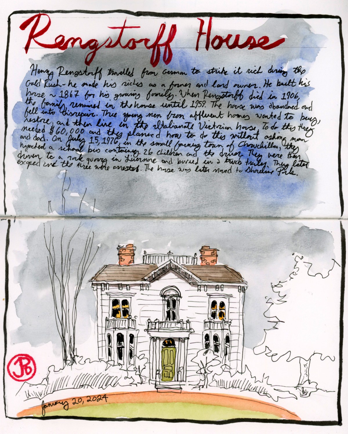
The Rengstorff House was one of the first houses built in Mountain View.

What piqued my interest in the circa 1867 house was an article in a Palo Alto weekly newspaper that a fellow teacher gave me. The article told the story of the Rengstorff House and the link to the countries largest mass kidnapping. What?!

The house was built by businessman Henry Rengstorff, a German immigrant that came to California to strike it rich during the Gold Rush. He made his money my farming and buying up land. He died in 1906 and afterwards, members of his family lived in the house until 1959.

The Rengstorff House at its new location.

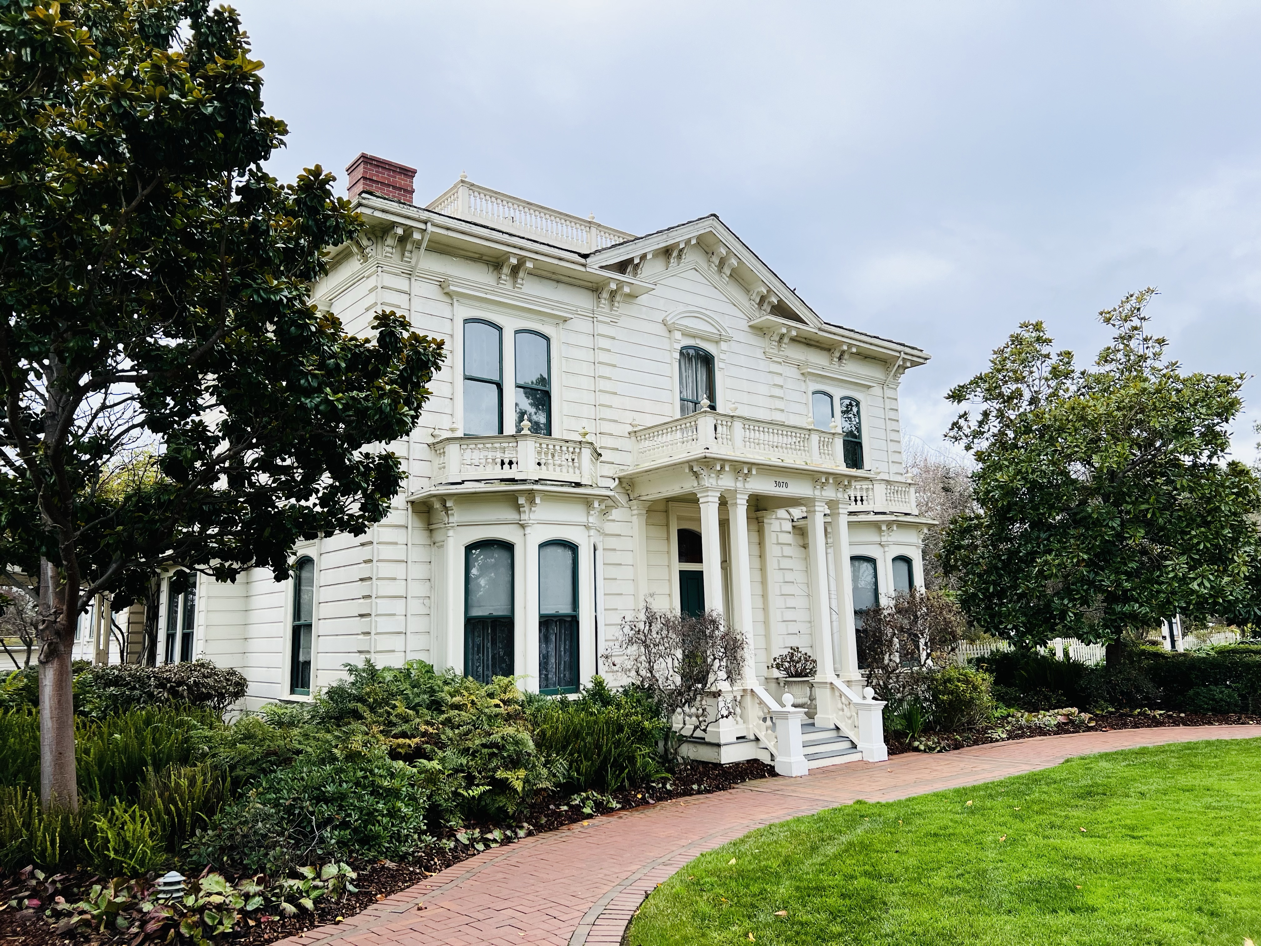
The land that the house was on, was sold to a land developer. In the mid 1970s, three young men had the dream of buying the house, (which had been abandoned and was now dilapidated) moving it to a new location, restoring it, and then living in it because they had always wanted to live in a historic mansion.

The young men were from the affluent communities of Portola Valley and Atherton and came from wealthy families.

So they hatched a plan to raise funds to buy the Rengstorff House.

On July 15, 1976 in the tiny farm town of Chowchilla, California three armed assailants hijacked a school bus containing 26 children who were returning from a swim party at the local community pool. The bus was hidden in a local slough and the bus driver and children were transferred to two vans and driven 100 miles away to a rock quarry in Livermore.

The children and driver were transferred to a truck trailer that was buried in the ground and the entrance was covered. The kidnappers left and planned to ransom their victims for $5 million. When they called the Chowchilla Police Station with their ransom note, they couldn’t get through because the station was flooded with calls by concerned parents.

The children and driver escaped and the son of the owner of the rock quarry became the number one suspect.

All three kidnappers were captured and later sentenced to life in prison. All three are now out of prison on parole.

They were not able to buy the Rengstorff House and it was later relocated to Shoreline Park in Mountain View and is now a museum.

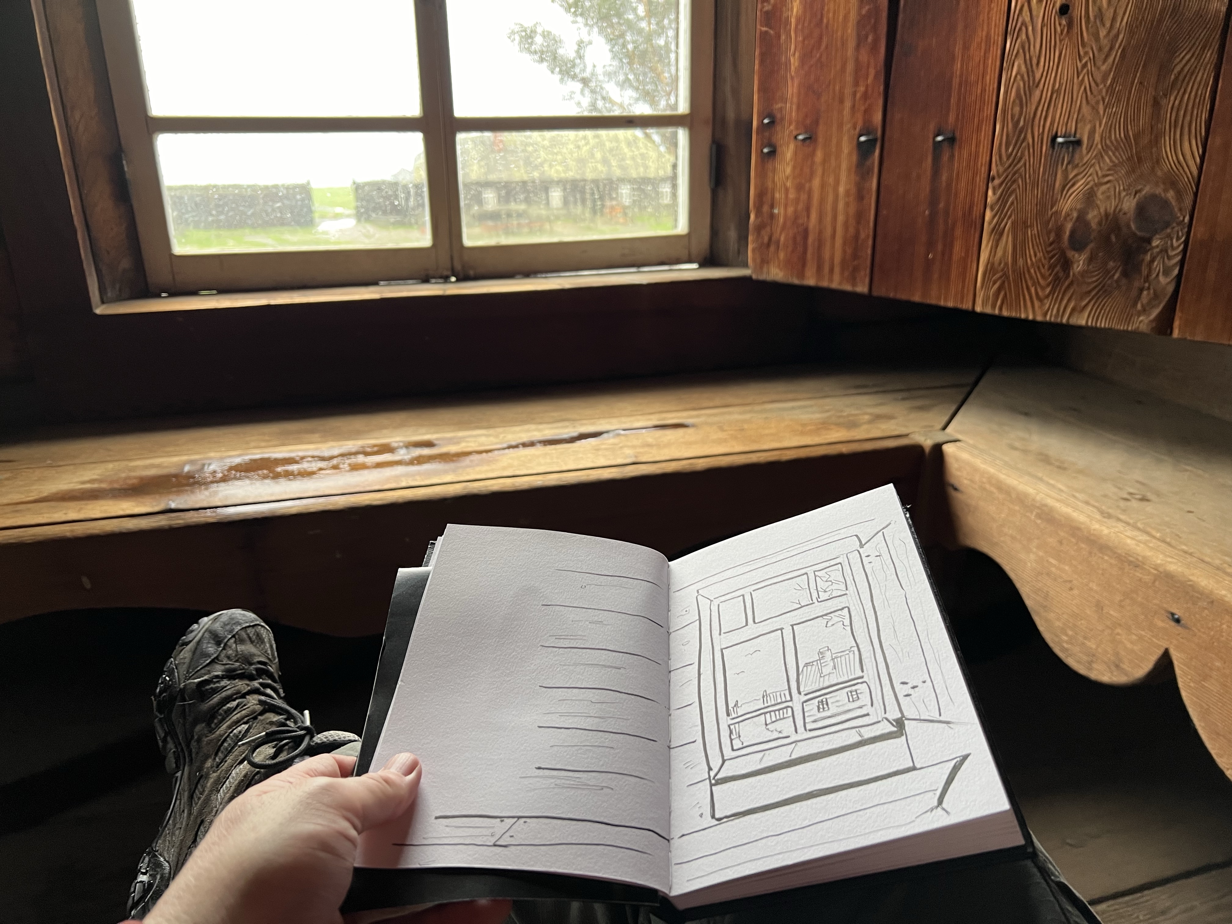
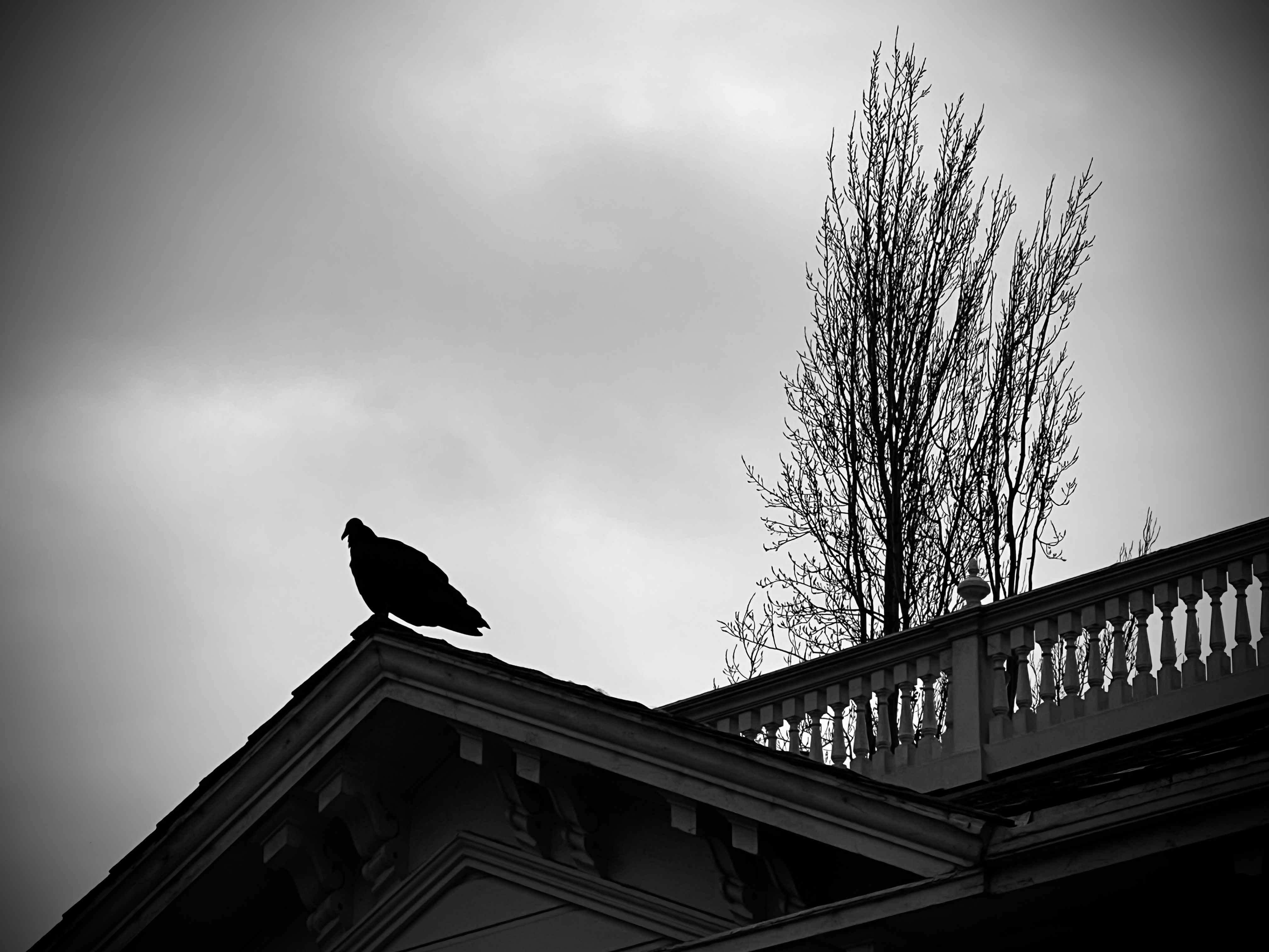
In between rain showers, I headed down to Mountain View to sketch the historic house. When I arrived there was a turkey vulture perched on the front gable.

After my sketch I walked around to the side to see if I could get a tour of the interior. The house was just closing for a private event.

I mentioned the recent article to the docent. She told me there were inaccuracies in the article and the writer didn’t even interview any staff at the museum about the story. When I asked about the Chowchilla Kidnappings, she replied, “We don’t talk about that.”

No wonder the Palo Alto Weekly didn’t consult the museum.

Image

Elephant Seals of Point Reyes Lifeboat Station

It’s always nice to head out to the Pacific Plate, a mere 90 minutes from my humble abode.

On this holiday Monday I was heading out to the outer point of Point Reyes National Seashore. My destination, Chimney Rock and the Point Reyes Lifeboat Station.

The new lifeboat station was built near Chimney Rock in 1927. Lifeboats could be quickly launch on rails into the calm waters of Drakes Bay. And over the years the lifeboat of Chimney Rock saved many a sailor.

With the advent of Coast Guard cutters and helicopters the station became redundant and was decommissioned on December 16, 1969.

The rails that launched lifeboats into Drakes Bay.

For over 150 years, no elephant seals were seen in Point Reyes and then in the early 1970s (after the lifeboat station was decommissioned), they returned to beaches at the Point Reyes Headlands. In 1981, a breeding pair was discovered at Chimney Rock. The seal population at Point Reyes has been growing ever since.

The beach on either side of the station was being used as an elephant seal birthing beach. The seals were mostly female with a few pups and one male beach master (featured sketch).

At the lifeboat station you could get surprisingly close to these large marine mammals.

I pulled out my sketchbook and started to draw the blubbery contours of the beach master. He was very accommodating, spending much of the sketch playing silent statue.

After my sketch he reared up and bellowed, claiming his patch of the earth and his harem.

The beach master in full bellow. Yes I was so close I could almost smell his breath!
Image

Chimney Rock

I headed out on the Chimney Rock Trail at outer Point Reyes. There were just two other cars in the parking lot.

Ravens and turkey vultures were my avian companions as I headed southeast on my way to Chimney Rock. Below, on hidden beaches I could hear the bellowing of elephant seals.

The trail view of the Historic Point Reyes Lifeboat Station with Drakes Bay.

The out-and-back trail is just under two miles and affords great views of Drakes Bay and the Pacific Ocean. On clear days you can see the Farallon Islands.

The Farillions seem much closer on the outer point.

On my return journey I sketched the Point Reyes Headlands from the trail (featured sketch). I liked the lines of the earth from this view and thought adding watercolor to the sketch would dampen its effect so I left it unpainted. With a sketch it is sometimes important to know when to stop.

Image

Portola, the Ohlone, and Sweeney Ridge

Just after 9:30 AM I set out on my ascent to Sweeney Ridge.

The path to the ridge is not a dirt trail but a graded paved road which is an extension of Sneath Lane which runs east to El Camino Real.

This road was built to service the Nike Missile Control Site (SF-51) that was active on the ridge from the 1950s to 1974.

Sweeney Ridge, along with Marin Headlands to the north, is now part of the Golden Gate National Recreation Area.

Sneath Lane on the ascent to Sweeney Ridge. From the trail head the almost two mile hike took me 45 minutes. In that 600 foot elevation gain I would be on the ridge at 1,200 feet.

On the way up, looking south, the sun was reflecting off of San Andreas Reservoir. The reservoir is part of the San Francisco Water District and covers the active San Andreas Fault.

San Andreas Fault and Reservoir in the background and Sneath Lane in the foreground. Almost at the summit.

My destination and sketching stop would be the Portola San Francisco Bay Discovery Site. This is the location where on November 4, 1769, the first Europeans set eyes on the San Francisco Bay.

The way history of Spanish Exploration of California has been written negates that the Ohlone had already been on the land and had already seen San Francisco Bay centuries before. So the idea of San Francisco Bay being discovered in 1769 is a fallacy.

I had not been to the Discovery Site in a few years and I was surprised to see that the 1975 serpentine rock that is the Discovery marker was boarded up. The sign on the board read: “The plaque is under repair. We apologize for the inconvenience. Sincerely, Golden Gate NRA staff”.

Now I wasn’t sure if park staff was covering up the inscription that is carved into the rock which reads: “From this ridge the Portola Expedition discovered San Francisco Bay, November 4, 1769” to hide the content from visitors or protecting the marker from vandalism. Perhaps they were doing both. (I later found out that the sign had been vandalized and now the board covering the vandalized maker is now vandalized with the words: “WOKE CENSORSHIP”.)

Just east of the stone marker two information panels have been installed filling in the history of the Ohlone people.

On the western side of the ridge is the town of Pacific. This is were the Portola Expedition set off. Near the community center there is an odd stature of Portola, one hand on his boxy sword, the other clutching a rolled up map.

The statue is by Josep Maria Subirachs, a Catalonian sculptor responsible for the statues on the Passion Facade on Gaudi’s masterwork, La Sagrada Familia in Barcelona.

A few years ago I had the opportunity to sketch the cathedral that is still under construction. And I sketched some of the figures on the Passion Facade.

My 2019 sketch of Subirachs’ Passion Facade.
On Thursday January 18, 2020, the Cabrillo statue was removed.
Image

Christmas at Gray Lodge

Every Christmas morning for the past 15 years or so, I drive about an hour west from my mom’s house to look at wintering birds at Gray Lodge Wildlife Refuge.

The 9,100 acre refuge provides watery winter habitat for over one million birds. It is also home to 300 species of birds and mammals, although many waterfowl head north in the spring.

Hundreds of geese, mainly snow geese, take to the air with the Sutter Buttes in the background. It is a sight and sound that I look forward to every Christmas. There’s nothing like this in the animal world.

The auto route is a way to view wildlife in your movable bird blind. As long as you stay in your car, the ducks, geese, cranes, hawks, falcons, eagles, and vultures.

There are thousands of waterfowl at Gray Lodge and that also means there are often dead waterfowl and the refuse workers of the refuge are the ubiquitous turkey vultures.

There are a few place where you can get out of your blind and stretch your legs and empty your bladder. At one of these stops you can walk over to an “observation hide”. This is a way to view birds without them viewing you.

The Betty Adamson Observation Hide, aka my Gray Lodge sketching house.

There were not too many viewable birds outside the windows (a hundred not thousands), so I sketched the view with the Sutter Buttes in the background (featured sketch).

It was also a great day for bald eagles. At the end of the morning I saw seven eagles, five adults and two sub adults.

Image

Gualala Point

After three days of rain, the sky cleared and the wind let up.

It was time to do a little hiker-sketching at Gualala Point Regional Park in the very northwestern corner of Sonoma County. Once you head north over the Gualala River, you are in Mendocino County.

This is a great place to whale watch but at this time of the season the grays were not migrating. So I found a dry bench and sketched the vista looking northwest with the serpentine Gualala River in the foreground and the Pacific behind (featured sketch).

I choose to paint the scene in sepia, leaving the Gualala River unpainted to highlight the form and path of the river.

The rugged coast of Gualala Point.
Image

Seals of Sea Ranch

There are more mammalian residents than the Patagonian clad bipeds, coyotes, or the migrating gray whales of the near shore of Sea Ranch.

These are the harbor seals (Phoca vitulina), that use the coves as a rookery to raise their young as well as using the beaches as haulout sites to rest.

The harbor seal has the widest distribution of any pinniped (eared seals, walruses, and true seals). The harbor seal is a true seal while the California sea lion is an eared seal.

I took advantage of a midafternoon clearing in the rain to do some pinniped sketching. I started at the Shell Beach parking lot at 3:30. The gates closed at sunset, which was at 4:56, so I would have a limited time to sketch before getting back to the car in time. I didn’t want to get locked in!

From the parking lot I made it to the T- junction with the Bluff Trail in 12 minutes. I turned right and headed north in search of resting seals.

I headed out to the point at Shell Beach, the wind threatening to dislodge my hat, and once I made it to the fence, I looked down.

Seals! Harbor seals hauled out on the rocky beach. I was about 30 yards away from the seals and only one looked up and eyed me with large, dark eyes, before returning to rest. These seals were not disturbed by my presence. Which is a testament to the respect that Sea Ranchers have shown to generations of seals over the decades.

I took out my journal, using my clips to keep the pages open in the wind and started to sketch the seals. They were good subjects because they rarely moved.

The challenge was to give the impression of the number of harbor seals without making them look like logs! I hope I succeeded! (Featured sketch).

The only California sea lion I saw was a statue in Gualala Point Regional Park. So I sketched it.

Image

Recreating at The Sea Ranch

While hiking, fishing, biking, boating, birding, and nature loafing are a popular recreation activities for early Sea Ranchers, they also needed a center to swim and play tennis (and currently, pickle ball).

To this end, three recreation centers were designed and built. The three centers are: Moonraker (1965), the Ohlson (1971), and the Del Mar (1996) Recreation Centers. All the centers where designed in the Sea Ranch style: sloping roofs, barn-sided, and harmonizing with the natural landscape.

There was also function to their forms as the constant prevailing northwestern winds were an environmental impediment to recreating. To this end the architects use of berms and wind-breaks were used to shield the cold winds from the wet, bathing-suited Sea Ranchers.

I wanted to sketch them and I started with the first rec center ever built at Sea Ranch: Moonraker.

It was raining rather vigorously so I sketched the exterior from the shelter of my waterproof sketching blind aka my car (featured sketch).

The Moonraker is an innovative design. The changing rooms are a long, henge-like building which shelters Sea Ranchers from the northwestern winds. The pool and tennis courts are sunk into the landscape, providing an oasis from the prevailing Pacific gales.

The men’s changing rooms at Moonraker. The graphics were designed by Barbara Stauffacher Solomon. The work that she did at Moonraker are considered to be the genesis of the Supergraphics movement.

My next experience with a rec center was more immersive. This was at the second rec center built at Sea Ranch: Ohlson Recreation Center.

With my rental I had access to all three rec centers and I wanted to take a dip at my favorite.

Wow, what a face this presents to the wind. To the right are the tennis courts and as at Moonraker, the structure provides a wind break.

This is the Ohlson Recreation Center. I have always appreciated the design of this center since the first time I saw photographs of it, I’ve loved it. It looks like a futuristic barn that has been on the land for centuries.

I checking in, headed to the door marked “M” and converted into bathing attire. On this cold winter’s day, the heated waters of the wallowing end was perfect.

I thought doing the back waddle in the wallowing side of the pool was a perfect way to enjoy the lines, angles, and surfaces of this iconic Sea Ranch structure. Too bad my sketch book was back in the changing room (and not entirely waterproof!).

A little presoak sketch of the fabulous recreational barn that is the Ohlson Recreation Center, completed in 1971.
Image

Sea Ranch and Lawrence Halprin

One of the leading lights of the development of The Sea Ranch on the northern Sonoma County Coast was Lawrence Halrprin (1916-2009).

A ten mile stretch of coast (formally a sheep ranch) was purchased with the intention of building a community that did not fight against its location but became part of it. The placement of houses and the design of the architecture was intended to mimic the shape of the hills, meadows, and tree lines of the location.

Halprin was hired on to develop the master plan for The Sea Ranch. This was a tall task to develop a new cultural utopia, even a blueprint for all future development. This was a chance to create a new architectural language that could be translated to other locations.

I connect with the works of Halprin in many ways.

I love the way the land becomes the centerpiece of The Sea Ranch. I can’t wait to sketch it, again!

I also love to look at the sketches of Halprin. He thought in sketches of pencil, ink, and watercolor. Halprin captured the landscape in his sketches. He spent a lot of time at Sea Ranch and he had a house here.

Halprin’s words live on in the Sea Ranch Lodge.

The Sea Ranch is a touchstone that I return to for inspiration, quiet, and sustenance. I love being here and sketching here.

When my father died I retreated to the Sea Ranch Lodge to have some quiet time and write my comments for his celebration of life ceremony.

For the feature sketch I attempted a mild, if not failed, caricature of Halprin donning a barn-sided suit. In the background is his studio at The Sea Ranch where he worked while he was on his land at The Sea Ranch.

The above sketch of the house next to my Sea Ranch rental demonstrates some of the Sea Ranch principles in design. The sloped roof, facing into the wind provides a wind-break on the lee-side of the structure (to the right). The house is also sided in natural vertical wood, reflecting the barn influences of some of the first structures on the land. There is also the influence of nearby Fort Ross and it’s chapel.

What is not reflected in the Utopian plans of Sea Ranch was the view from my front room. The original design called for open views across a common meadow to the ocean. From my wall of windows I could see a golf links, a road, a line of house and finally, just beyond the houses, the Pacific Ocean.

Like the name implies, Utopias don’t always live up to their founder’s vision.

And there are always more people with more money than sense to come along and screw it up!

Image

Fort Ross, A Sketcher in the Rain

As my north coast journey approached I looked to the weather forecast of the Sonoma Coast, one weather phenomenon dominated: rain.

I wasn’t going to let this dampen my field sketching mojo. I planned to sketch at Fort Ross, no matter the weather. Call me the postal worker of sketching! Corvids don’t mind the rain.

I had everything I needed for wet weather: rain jacket and pants, umbrella, and a dry bag for my journals.

A November 2015 sketch of the Fort Ross Chapel in better sketching conditions.

Fort Ross is one of those coastal sketching touchstones that I have returned to again and again. This was the first time I had visited with 100% humidity.

Now you can’t have watercolor, as the name implies, without water. But a deluge of rain is a bit too much water. And applying ink to damp paper will cause the ink to run or smudge which can become part of the story of the final sketch.

Now this bed just looks icy cold.

Visiting Fort Ross on a cold, rainy, and windy day gave a me a first hand experience of what it must have been like to spend the winter at the fort. It was dark in the houses even in the middle of the day. No electricity, no television, no smartphones, and no emojis. Cabin fever anyone?

The plus side is that I had the fort all to myself!

The Russians added some new species to the scientific record, of course they couldn’t tell the native people something they didn’t already know.

I knew the perspective I wanted to sketch from: along the barricade looking west toward the guard tower. Seems perfectly fine while you’re planning in your cozy abode; far harder to do in the realities of rain and wind.

I had my umbrella to keep the rain off my journal. Well my umbrella was absolutely useless in these fierce coastal gusts. Trying to concentrate on my sketching while attempting to prevent my umbrella from launching into the local watershed was a struggle.

I had to abort the sketch without actually committing pen to paper. It was time to find shelter from the wind and the rain and commit a sketch to my journal.

I chose as my sketching blind, the second story of the Kuskov House. Great view, dry, and less chilly.

Call me a cheater but by hook or by crook, I got my rainy day sketch in under the timbers of the Kuskov House.