Image

Tanforan Siding

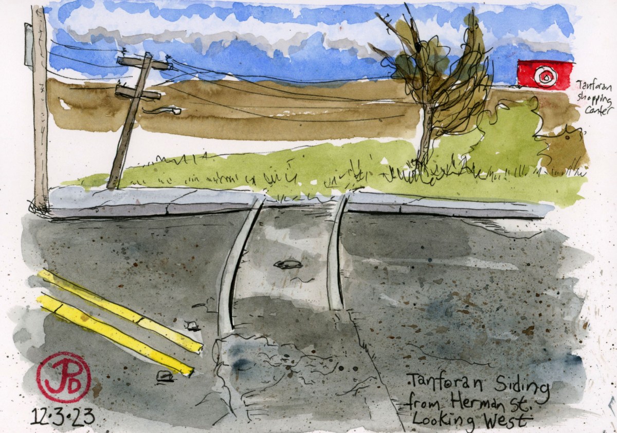
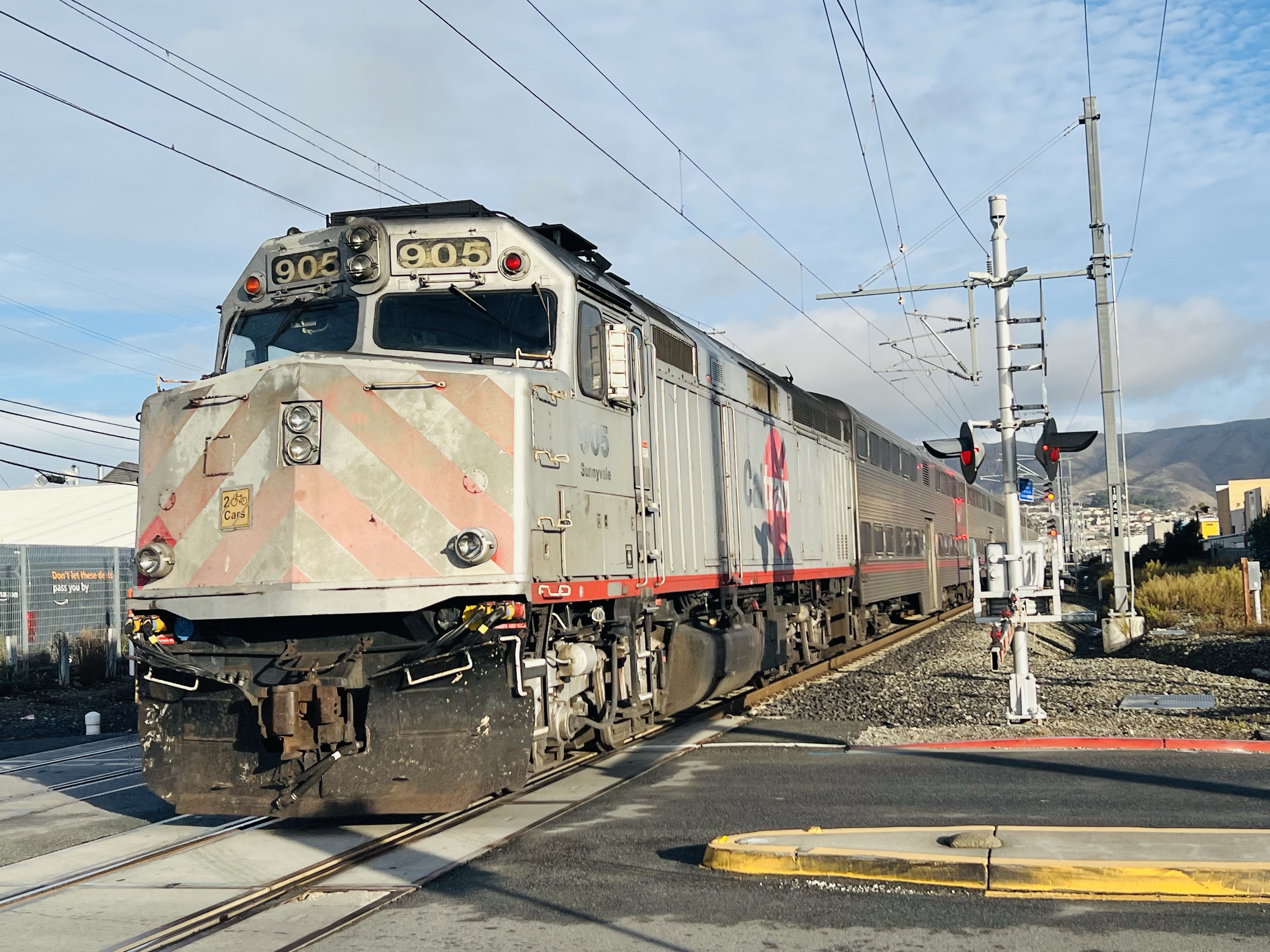
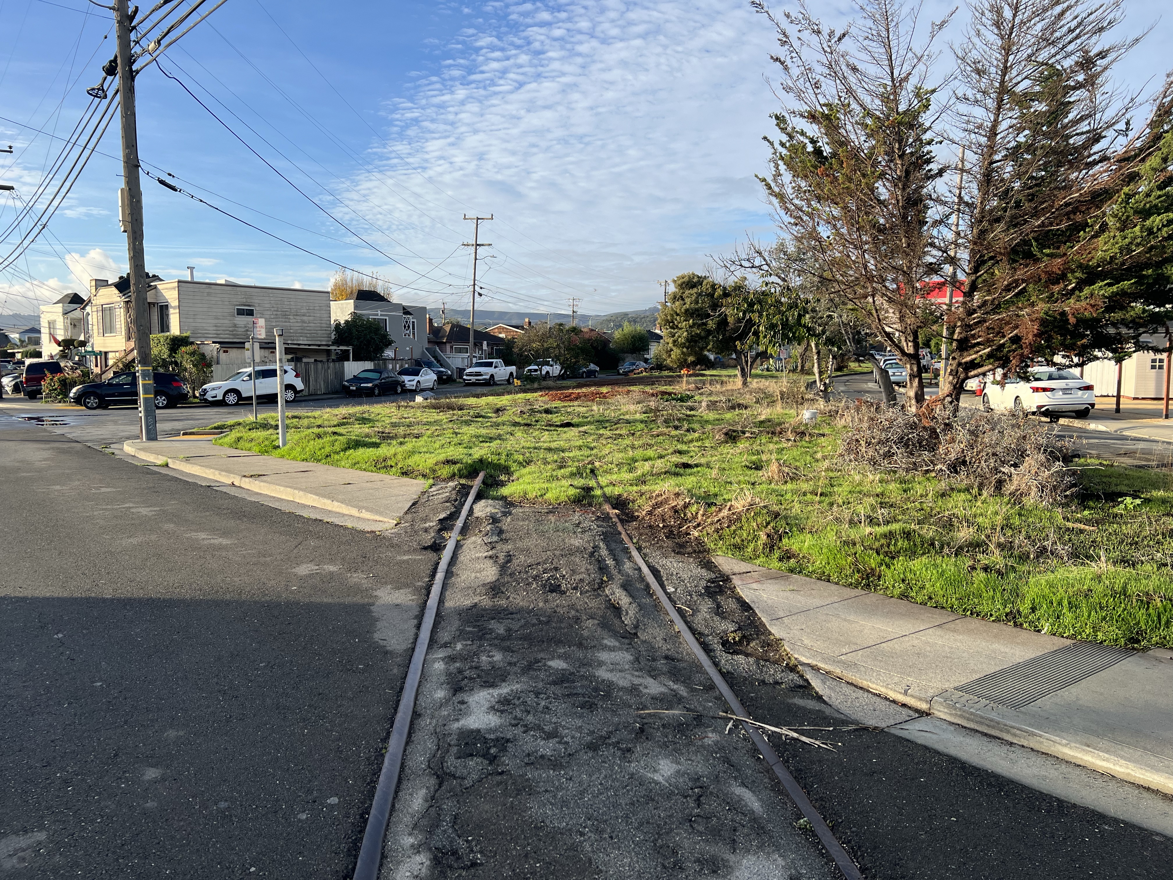
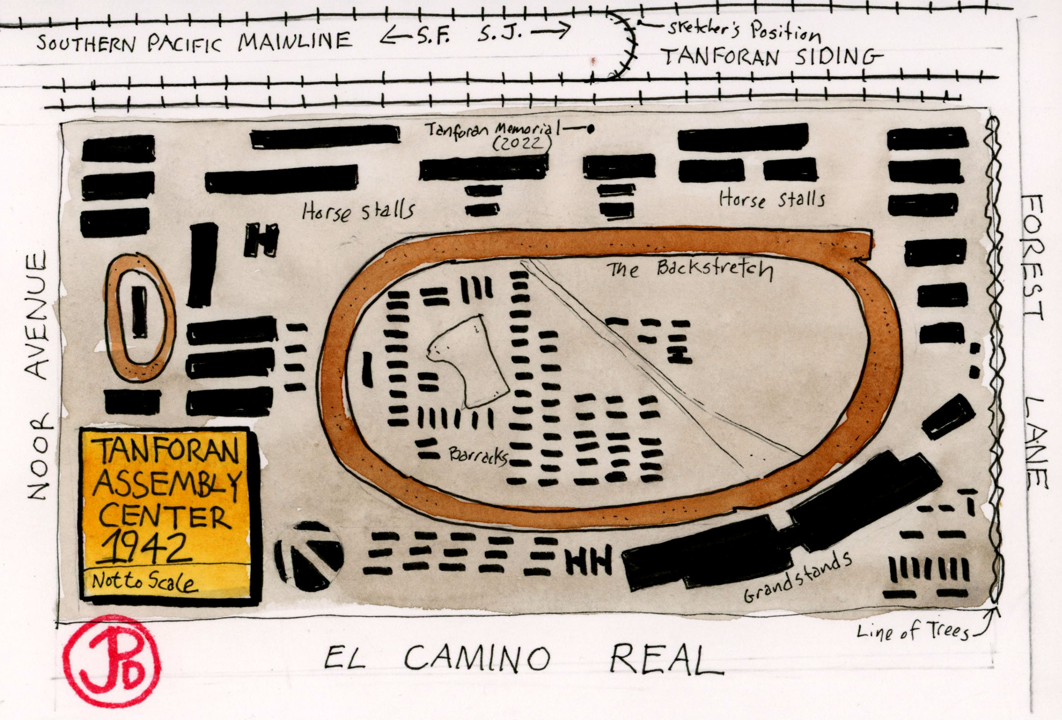
The former racetrack at Tanforan is bordered on one side by the former Southern Pacific mainline (currently used by the passenger service Caltrain).

Heading south, the line joins the wider rail network at Santa Clara and San Jose and on to all points on the National railroad compass.

The rails are still very much in use as a northbound Caltrain heads to San Francisco. The train is being pushed by locomotive EMD F40PH-2 No 905 “Sunnyvale”. These diesel-electric locomotives will soon be replaced by electric train sets.

Tanforan was, therefore, connected to the nation through the siding track that brought cars from Tanforan Park proper, to points north (San Francisco) and south (San Jose).

The Tanforan Siding heading towards the former racetrack (now Tanforan Shopping Center). This is the track that connected the siding near the backstretch with the rest of the rail network.

In 1938 the famous thoroughbred racehorse Seabiscuit boarded a special horse baggage car at the Tanforan Siding and he was shipped across the country to the East Coast on his first attempt to beat War Admiral. Large crowds came to see Seabiscuit off at the siding. The first meeting of these racing heavyweights did not happen.

Tanforan does have a dark past. In 1942, the racetrack became the Tanforan Assembly Center (the only assembly center in the San Francisco Bay Area). After the attack on Pearl Harbor, President Franklin D. Roosevelt issued executive order 9066. As a result Japanese Americans where rounded up and about 8,000 men, woman, and children where brought to Tanforan Racetrack now newly christened the Tanforan Assembly Center (one of twelve assembly centers on the West Coast).

Two-thirds of the detainees were U. S. Citizens, born and raised in the United States.

The Tanforan Memorial outside the San Bruno BART Station. The sculpture is based on a 1942 Dorothea Lange photograph of a family on their way to Tanforan. The memorial was dedicated on August 27, 2022.

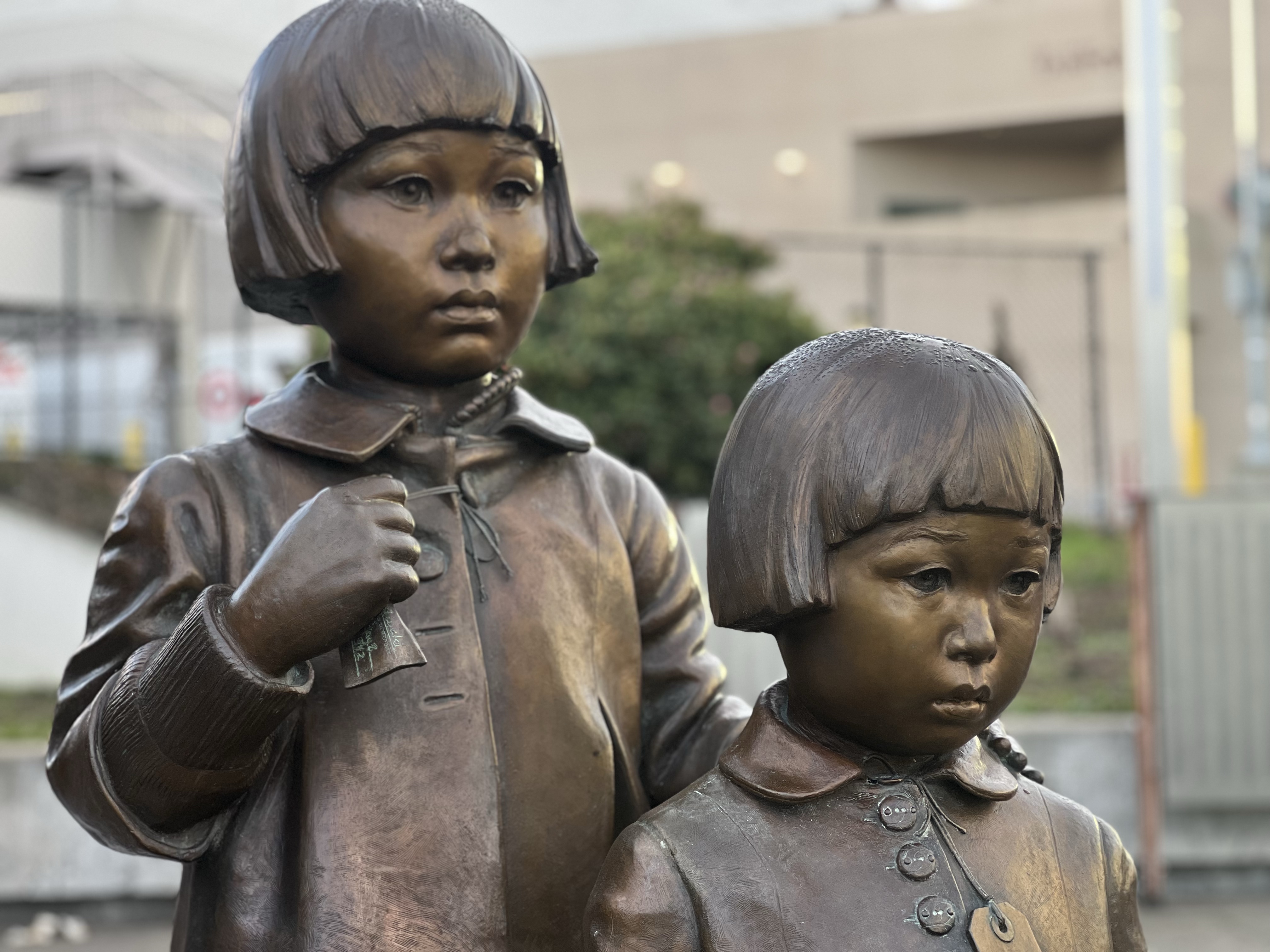
The first internees arrived on April 28, 1942. They were housed in barracks and horse stalls that reeked of manure and urine. Some families spent about eight months here before being transported, over rail, to the Topaz War Relocation Center in Utah where they remained until the end of the war.

By the fall, the detainees were being sent on a two day rail journey to the Topaz War Relocation Center. On September 9, 1942, the first group of 214 detainees entered the siding that Seabiscuit travelled on a few years earlier and entered the mainline for their trip to the wastes of northeastern Utah. On October 13, 308 detainees, the last to leave Tanforan, entered the siding and then on to Utah.

The Tanforan Assembly Center was now closed.

The site of the former track and assembly center is now a shopping mall.

In 2022 the mall was bought by a developer and there are plans to raze the mall and build a massive biotech campus.

Image

Fort Humboldt

Who knew that the Northern California town of Eureka had some Civil War and presidential history?

Such is the case when a young captain who served at the fort for five months. He was a loner and spent his free time in local taverns and riding in the countryside. It is said that he developed a taste for whisky while at Fort Humboldt. His name was Ulysses S. Grant.

Of course he went on to become a Civil War hero where he commanded the Union Army. It was Grant that Robert E. Lee surrendered to at Appomattox Courthouse on April 9, 1865.

Grant later served as the 18th president from 1869-1877 serving two terms.

There are not many original buildings left at Fort Humboldt but here is where the commissary once stood. Grant served as the fort’s quartermaster, probably at the commissary.

There is not much left of the fort on the bluff above Humboldt Bay and the fort hospital is the only remaining structure of the fort period (from 1853-1870). I pulled up my sketching chair and sketched the hospital building on the left of my spread. On the right is one of the largest steam donkeys ever made.

The state park has some nice relics of the lumber era that put Humboldt County on the economic map.

Image

Northwestern Pacific’s Eureka Slough Bridge

It was a cold, clear, and crisp morning in Eureka, a perfect day for railroad sketching.

Pre-trip, the Northwestern Pacific bridge over Eureka Slough was high on my sketch list. This bridge has had a major rebuild at least once and now looks to be in good shape

I pulled onto Y Street, any further north and I’d be in Arcata. At the end of the street is the rusted railroad and pedestrian path that follows the shoreline (The Waterfront Trail). I headed right on the trail (north) to where the path comes to the slough and then heads east. Of course the railroad proceeded north by conquering Humboldt Slough with a bridge. And that’s what I was here to sketch.

I had thought about bringing along by sketching chair but when you have the Steam Engine Bench with a capital view of the slough and bridge, why bother?

The Steam Engine Bench has to be one of the best sketching seats I have ever sketched from!

It was a beautiful morning to sketch and my pants absorbed the wet bench. I had to use a lot of sketcher’s shorthand and leave off the vast amount of graffiti that the bridge was covered in. I did keep the words, “OLD CROW” painted into seven panels of the bridge.

The bridge looking north towards Arcata which was as far as Northwestern Pacific ever reached.
Sketched from life!
Image

Diamond Springs Creamery, Loleta

I love sketching old abandoned historic buildings. And if they were featured in sci-fi horror cult film, even better.

The Diamond Springs Creamery was built in 1893 in Loleta, California. Which is about 20 miles south of Eureka. The location of the plant would make sense because it is in the middle of California Coastal cow country and on the route of the Northwestern Pacific mainline, bringing dairy to points south including San Francisco.

The dairy plant is very large, perhaps three blocks by six blocks. A good portion of the town must have worked at the plant making Loleta a real company town.

Now the brick building is falling apart with broken windows and covered in graffiti. It was in operation for over one hundred years, stopping production in 2007 and finally being abandoned in 2010. It is now surrounded by a fence with many “No Trespassing” signs on display. This must be to keep graffiti artists and film geeks at bay.

The slowly crumbling milk plant.

In 1982, Loleta filled in for the fictional town of Santa Mira and the creamery stood in for the Silver Shamrock Novelties factory in the film Halloween III: Season of the Witch.

While the film made a profit, it was the lowest grossing film in the Halloween franchise. It probably shouldn’t have been called Halloween III because it gave the false expectations that it was going to star a man in a doctored Captain Kirk mask with a large knife. This film does feature masks but not Michael Myers.

Screen shot of the creamery plant decked out as Silver Shamrock Novelties from Halloween III: Season of the Witch.
Another angle of the creamery. The structure on top once displayed the Silver Shamrock logo.
Image

Eel River Canyon

One of the biggest challenges of building a railroad from Willits to Eureka is the Eel River Canyon. And the Northwestern Pacific Railroad (NWP) definitely had their hands full with this engineering challenge.

Parts of the NWP mainline is still in use as the Skunk Train pulled onto the mainline at the Willits Depot. Unfortunately the Skunk is heading in the opposite direction of Eel River Canyon. (For very good reasons).

13 miles north of Willits the Northwestern Pacific (NWP) line crosses Highway 101 and begins to parallel Outlet Creek.

The rusted rails of the NWP heading north towards Eel River Canyon.

Just north of Willits I turned left onto Highway 162 (Covelo Road). I wanted to follow the railroad as far north up the Eel River Canyon that I could. I figured I would get as far as Dos Rios before I ran out of road.

There were some key sites in the Eel River Canyon that I wanted to see: Cain Rock and Island Mountain but these were so far off Highway 101 on long and windy roads (some on private roads that seemed very inaccessible). I wanted to avoid trespassing in Mendocino or Humboldt Counties! (Think shotgun!)

One of my sketching destinations was the train trestle over Outlet Creek near the confluence of the creek with the Eel River.

I pulled over just as I crossed the Eel River and set up my sketching chair to add the trestle in my Beta panoramic book (featured sketch). The field sketch is on the left side and as the pictures moves to the right, the color turns to sepia and a steam locomotive pulling a passenger consist, is heading down canyon towards the trestle. The spread is a look back in time.

After the sketch I continued to follow the line towards Dos Rios on Highway 162. I came upon a tunnel, NWP Tunnel 14.

Tunnel 14 in the Eel River Canyon.
This photo shows one of the problems with keeping the line open, both then and now. Here a landslide has covered a large section of the track. Think how expensive it would be to stabilize the hillside and reopen the line. This is one of many slides along the canyon.
Image

Frog Woman Rock

An imposing landmark on Highway 101, just south of Hopland is Frog Woman Rock (formerly known as Squaw Rock).

This was a barrier to the progress of the railroad that was following the Russian River on it’s West Bank. They could not go around the monolith so they had to tunnel through it.

This became the 1,270 foot Tunnel No. 8 on the Northwestern Pacific Railroad (NWP). While this monolith was a new delay to the railroad’s northern progress, the local Pomo people knew this location very well.

Frog Woman Rock with Highway 101 in the foreground.

To them it was know as Bi-tsin’ ma-ca Ka-be, Frog Woman Rock.

There are various legends of how the rock got its name. One Pomo story, filtered through early settlers, is that the rock was a sort of “Lover’s Leap” featuring in a lover revenge quarrel of the scorned Sotuka. Other say Sotuka is the wife of Coyote the trickster and the Pomo people avoided the rock. While others believe when the railroad tunnels through Frog Woman Rock, it released evil spirits.

Whatever the “truth” behind the legend of the rock, it was always be hidden in the past.

In 2024, Frog Woman Rock was designated California Historical Landmark No. 549. The plaque reads:

Since time immemorial, this monolith has been revered by Pomo people as the home of Frog Woman, the consort of coyote, and a special being in her own right. For native people it is a place of sacred power and a reminder of the connection we still have with our spirituality and natural environment. The presence of this great rock on the local landscape is a solemn witness that will forever be a local symbol of our indigenous collective conscience, strength, and perseverance.

The abandoned NWP train station at Hopland, six miles north of Frog Woman Rock, with rusted rail leading north (to the right) to Willits and Eureka.