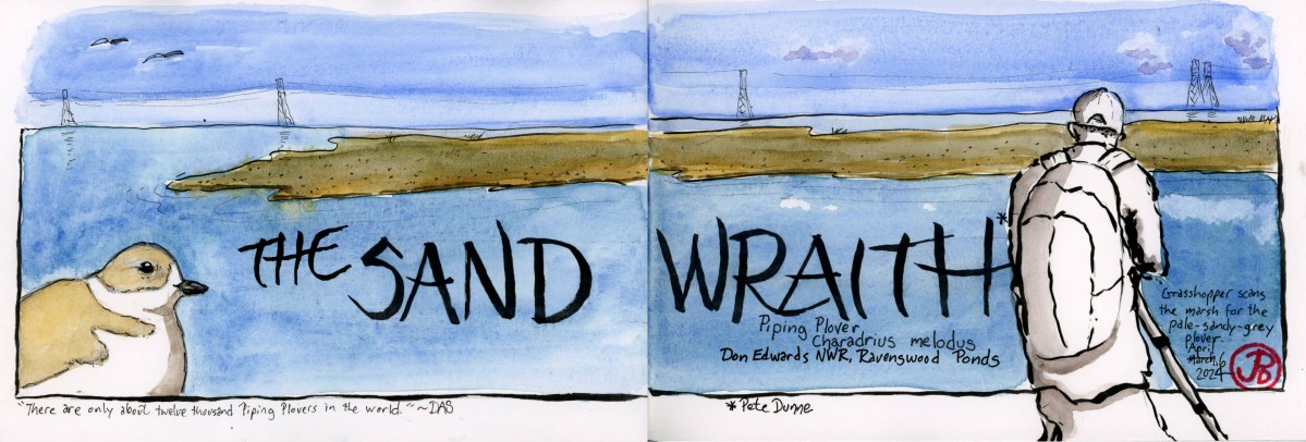
Image

The Arctic Toothwalker

High on my Arctic pinniped (fin-footed) wishlist is Odobenus rosmarus: the walrus.

Few animals scream “Arctic” in the same way as the Toco toucan screams “tropics” or “rainforest” or “Guinness”, as the walrus. These animals are the “sexy megafauna” that become the poster animal for the ecosystem. (Okay the toucan isn’t “mega” but its bill sure is). For the Arctic, I would certainly put polar bear at the top of this list, followed closely by the walrus.

This Arctic animal is also keynote species that are the “carnies in the coal mine” for their ecosystems. When the walrus population declines, we know that the Arctic is not healthy.

The walrus’s most prominent feature are its tusks. They are sported by both male and females and are really enlarged canines. Tusks on males can grow to three feet. They use these ivories for male scuffling and pulling their hefty bulk up onto ice.

The walrus is also one of the largest pinnipeds in the world, only exceeded by the Northern and Southern elephant seal. It can be said that it is the second largest pinniped in the Northern Hemisphere. Walrus are sexually dimorphic with males weighing almost two tons and growing to 12 feet in length.

Image

High Arctic Dreams

“I felt a calmness birds can bring to people; and, quieted, I sensed here the outlines of the oldest mysteries: the nature and extent of space, the fall of light from the heavens, the pooling of time in the present, as if it were water.”

― Barry López, Arctic Dreams

The major avian draw for traveling to the High Arctic is Pagophila eburnea, the “the ice-loving ivory-colored gull”. This would be an incredible lifer and the major totem for any birder visiting the top of the world.

Some cetaceans on my wishlist are the white whale (also known as the beluga whale), minke whale and fin whale.

I was also hoping to see some pinnepeds for the first time. They included: walrus and harp, ringed, and bearded seals.

Image

Search for the Prairie Ghost

Late January is the time to head to Solano County and look for the elusive Prairie Ghost. Also known as Dirt Claud Plover but officially by the improbable name mountain plover.

This plover is not found in the mountains but in the short grassland prairies or recently plowed fields. And unlike like other plovers it is not found near water (unless it’s a cattle trough).

Charadrius montanus winters in the fields of Solano County ( and other open places out west). To find this cryptic species you need a scope, luck, and lots of patience. The epicenter of wintering prairie ghosts is Robinson and Flannery Roads.

These country dirt roads are also a great place to view wintering raptors including harriers, merlin, prairie falcon, golden eagle, rough-legged, and ferruginous hawks.

Early on a Saturday morning, Grasshopper Sparrow and I headed to the Solano County birding hotspot known as “Robinson Road”. Mountain plover was his nemesis bird and after previous attempts, he had yet to add it to his life list.

Often this area can be shrouded in dense valley fog, making the plover that is already tough to spot, even tougher. But today, the skies were clear and sunny with vast visibility to find our quarry.

So it was that we found ourselves at 8:30 on Flannery Road looking south towards undulating green field being serenaded by western meadowlarks.

Now we were looking for feathered dirt clauds that had the power of “now you see me, now you don’t” invisibly. Once the plover turns its brown back to the viewer, hiding its white breast, it can be tough to find and it seems to melt into the dirt.

I scanned the fields with my binoculars, stopping at some prominent dirt clauds so I put the scope on them and they magically turned into mountain plovers. Lifer for Grasshopper!

Did that dirt claude just move? The mountain plover is no longer a nemesis bird for Grasshopper.

Sketching Notes: Before I headed out to Robinson Road, I sketched in the border and the outline of the mountain plover in the bottom left of my panoramic journal. I would add a field sketch of the fields on location. If we did not see the plovers I would outline the silhouette of the bird and leave it unpainted. But if we were successful, I would paint the outline in, which I did in the final sketch.

Image

Gates of Heaven, Santa Clara County

On film critic Roger Ebert’s list of the Ten Greatest Films of All Time, only one film is an American documentary (two out of ten films are documentaries).

This is the Errol Morris 1978 documentary Gates of Heaven. The film is about two California pet cemeteries, one in the Napa Valley and the other in Los Altos.

The film opens in Los Altos at Highway 280 and Foothill (I grew up two highway exits away). This is the site of the Foothill Pet Cemetery and Morris spends time interviewing the founder Floyd “Mac” McClure and other investors in the pet cemetery.

Some of the clients of the cemetery are also interviewed, including the woman with the “singing” pup and for comic relief, the manager of an animal rendering plant.

Mac has a lot of passion for his dream of opening a pet cemetery, he puts love above profit but one feels he isn’t the best businessman. The owner of the land, a Mr. Dutton, decides to sell the land to a real-estate developer and the pets, all 450, have to be exhumed and reburied in the another pet cemetery (Bubbling Well Pet Memorial Park in Napa Valley).

The second part of the film interviews the Harberts family which runs the Bubbling Well Pet Memorial Park. But not before one of the best monologues in documentary history from a Los Altos elderly neighbor, Florence Rasmussen, who lives across the street from the cemetery.

The documentary was filmed in the summer of 1977 and I was in search of the location of the cemetery on a rainy late morning.

Looking at maps, I noticed a trail (Hammond-Snyder Loop Trail) up to a hill that would give me a view of area to the south of Highway 280 and east of Foothill.

I set off on the muddy trail past a red-tail hawk perched in an oak. There was a light drizzle. In about five minutes I found myself on a small hill partially fenced in with an interpretative sign.

Looking to the north I knew I was standing at the cameras location from the panning shot at the beginning of Gates of Heaven.

A screen capture of the first panning shot in the film. The green water tanks are still there. The bridge in the foreground right is Cristo Rey Drive over the Southern Pacific Permanente Cement Plant branch line. In the background is Highway 280.
This screen capture, from the same panning shot as above, comes to rest here: the location of the Foothill Pet Cemetery between Cristo Rey Drive and Highway 280.
Here is the same view of the cemetery today. The distance fades into drizzling skies. There are more houses and trees than there were in 1977. The roads are very much the same as 47 years ago.

I pulled my panoramic journal out of my pack and quickly began a pen brush sketch of the scene before me, my lines blurred and smudged in the drizzle. These “happy accidents” became part of the sketch.

Parts of the scene were still recognizable: the green waters tanks, the railroad, the Foothill Blvd entrance and exit ramps, Cristo Rey, and Highway 280.

Where the pet cemetery was located is now a housing development and the trees now seem much taller and more plentiful than when the panning shot was filmed here almost 47 years ago.

Do the residents of Serra Knoll Estates know their houses are built on the site of a pet cemetery?!
Oddly enough there is a Catholic Cemetery called “Gate of Heaven” just down the road from the former Foothill Pet Cemetery. Did Morris get the idea for his film’s title here? Maybe only he really knows.
Image

The Rengstorff House

The Rengstorff House was one of the first houses built in Mountain View.

What piqued my interest in the circa 1867 house was an article in a Palo Alto weekly newspaper that a fellow teacher gave me. The article told the story of the Rengstorff House and the link to the countries largest mass kidnapping. What?!

The house was built by businessman Henry Rengstorff, a German immigrant that came to California to strike it rich during the Gold Rush. He made his money my farming and buying up land. He died in 1906 and afterwards, members of his family lived in the house until 1959.

The Rengstorff House at its new location.

The land that the house was on, was sold to a land developer. In the mid 1970s, three young men had the dream of buying the house, (which had been abandoned and was now dilapidated) moving it to a new location, restoring it, and then living in it because they had always wanted to live in a historic mansion.

The young men were from the affluent communities of Portola Valley and Atherton and came from wealthy families.

So they hatched a plan to raise funds to buy the Rengstorff House.

On July 15, 1976 in the tiny farm town of Chowchilla, California three armed assailants hijacked a school bus containing 26 children who were returning from a swim party at the local community pool. The bus was hidden in a local slough and the bus driver and children were transferred to two vans and driven 100 miles away to a rock quarry in Livermore.

The children and driver were transferred to a truck trailer that was buried in the ground and the entrance was covered. The kidnappers left and planned to ransom their victims for $5 million. When they called the Chowchilla Police Station with their ransom note, they couldn’t get through because the station was flooded with calls by concerned parents.

The children and driver escaped and the son of the owner of the rock quarry became the number one suspect.

All three kidnappers were captured and later sentenced to life in prison. All three are now out of prison on parole.

They were not able to buy the Rengstorff House and it was later relocated to Shoreline Park in Mountain View and is now a museum.

In between rain showers, I headed down to Mountain View to sketch the historic house. When I arrived there was a turkey vulture perched on the front gable.

After my sketch I walked around to the side to see if I could get a tour of the interior. The house was just closing for a private event.

I mentioned the recent article to the docent. She told me there were inaccuracies in the article and the writer didn’t even interview any staff at the museum about the story. When I asked about the Chowchilla Kidnappings, she replied, “We don’t talk about that.”

No wonder the Palo Alto Weekly didn’t consult the museum.

Image

Elephant Seals of Point Reyes Lifeboat Station

It’s always nice to head out to the Pacific Plate, a mere 90 minutes from my humble abode.

On this holiday Monday I was heading out to the outer point of Point Reyes National Seashore. My destination, Chimney Rock and the Point Reyes Lifeboat Station.

The new lifeboat station was built near Chimney Rock in 1927. Lifeboats could be quickly launch on rails into the calm waters of Drakes Bay. And over the years the lifeboat of Chimney Rock saved many a sailor.

With the advent of Coast Guard cutters and helicopters the station became redundant and was decommissioned on December 16, 1969.

The rails that launched lifeboats into Drakes Bay.

For over 150 years, no elephant seals were seen in Point Reyes and then in the early 1970s (after the lifeboat station was decommissioned), they returned to beaches at the Point Reyes Headlands. In 1981, a breeding pair was discovered at Chimney Rock. The seal population at Point Reyes has been growing ever since.

The beach on either side of the station was being used as an elephant seal birthing beach. The seals were mostly female with a few pups and one male beach master (featured sketch).

At the lifeboat station you could get surprisingly close to these large marine mammals.

I pulled out my sketchbook and started to draw the blubbery contours of the beach master. He was very accommodating, spending much of the sketch playing silent statue.

After my sketch he reared up and bellowed, claiming his patch of the earth and his harem.

The beach master in full bellow. Yes I was so close I could almost smell his breath!
Image

Chimney Rock

I headed out on the Chimney Rock Trail at outer Point Reyes. There were just two other cars in the parking lot.

Ravens and turkey vultures were my avian companions as I headed southeast on my way to Chimney Rock. Below, on hidden beaches I could hear the bellowing of elephant seals.

The trail view of the Historic Point Reyes Lifeboat Station with Drakes Bay.

The out-and-back trail is just under two miles and affords great views of Drakes Bay and the Pacific Ocean. On clear days you can see the Farallon Islands.

The Farillions seem much closer on the outer point.

On my return journey I sketched the Point Reyes Headlands from the trail (featured sketch). I liked the lines of the earth from this view and thought adding watercolor to the sketch would dampen its effect so I left it unpainted. With a sketch it is sometimes important to know when to stop.

Image

Portola, the Ohlone, and Sweeney Ridge

Just after 9:30 AM I set out on my ascent to Sweeney Ridge.

The path to the ridge is not a dirt trail but a graded paved road which is an extension of Sneath Lane which runs east to El Camino Real.

This road was built to service the Nike Missile Control Site (SF-51) that was active on the ridge from the 1950s to 1974.

Sweeney Ridge, along with Marin Headlands to the north, is now part of the Golden Gate National Recreation Area.

Sneath Lane on the ascent to Sweeney Ridge. From the trail head the almost two mile hike took me 45 minutes. In that 600 foot elevation gain I would be on the ridge at 1,200 feet.

On the way up, looking south, the sun was reflecting off of San Andreas Reservoir. The reservoir is part of the San Francisco Water District and covers the active San Andreas Fault.

San Andreas Fault and Reservoir in the background and Sneath Lane in the foreground. Almost at the summit.

My destination and sketching stop would be the Portola San Francisco Bay Discovery Site. This is the location where on November 4, 1769, the first Europeans set eyes on the San Francisco Bay.

The way history of Spanish Exploration of California has been written negates that the Ohlone had already been on the land and had already seen San Francisco Bay centuries before. So the idea of San Francisco Bay being discovered in 1769 is a fallacy.

I had not been to the Discovery Site in a few years and I was surprised to see that the 1975 serpentine rock that is the Discovery marker was boarded up. The sign on the board read: “The plaque is under repair. We apologize for the inconvenience. Sincerely, Golden Gate NRA staff”.

Now I wasn’t sure if park staff was covering up the inscription that is carved into the rock which reads: “From this ridge the Portola Expedition discovered San Francisco Bay, November 4, 1769” to hide the content from visitors or protecting the marker from vandalism. Perhaps they were doing both. (I later found out that the sign had been vandalized and now the board covering the vandalized maker is now vandalized with the words: “WOKE CENSORSHIP”.)

Just east of the stone marker two information panels have been installed filling in the history of the Ohlone people.

On the western side of the ridge is the town of Pacific. This is were the Portola Expedition set off. Near the community center there is an odd stature of Portola, one hand on his boxy sword, the other clutching a rolled up map.

The statue is by Josep Maria Subirachs, a Catalonian sculptor responsible for the statues on the Passion Facade on Gaudi’s masterwork, La Sagrada Familia in Barcelona.

A few years ago I had the opportunity to sketch the cathedral that is still under construction. And I sketched some of the figures on the Passion Facade.

My 2019 sketch of Subirachs’ Passion Facade.
On Thursday January 18, 2020, the Cabrillo statue was removed.
Image

Christmas at Gray Lodge

Every Christmas morning for the past 15 years or so, I drive about an hour west from my mom’s house to look at wintering birds at Gray Lodge Wildlife Refuge.

The 9,100 acre refuge provides watery winter habitat for over one million birds. It is also home to 300 species of birds and mammals, although many waterfowl head north in the spring.

Hundreds of geese, mainly snow geese, take to the air with the Sutter Buttes in the background. It is a sight and sound that I look forward to every Christmas. There’s nothing like this in the animal world.

The auto route is a way to view wildlife in your movable bird blind. As long as you stay in your car, the ducks, geese, cranes, hawks, falcons, eagles, and vultures.

There are thousands of waterfowl at Gray Lodge and that also means there are often dead waterfowl and the refuse workers of the refuge are the ubiquitous turkey vultures.

There are a few place where you can get out of your blind and stretch your legs and empty your bladder. At one of these stops you can walk over to an “observation hide”. This is a way to view birds without them viewing you.

The Betty Adamson Observation Hide, aka my Gray Lodge sketching house.

There were not too many viewable birds outside the windows (a hundred not thousands), so I sketched the view with the Sutter Buttes in the background (featured sketch).

It was also a great day for bald eagles. At the end of the morning I saw seven eagles, five adults and two sub adults.

Image

Gualala Point

After three days of rain, the sky cleared and the wind let up.

It was time to do a little hiker-sketching at Gualala Point Regional Park in the very northwestern corner of Sonoma County. Once you head north over the Gualala River, you are in Mendocino County.

This is a great place to whale watch but at this time of the season the grays were not migrating. So I found a dry bench and sketched the vista looking northwest with the serpentine Gualala River in the foreground and the Pacific behind (featured sketch).

I choose to paint the scene in sepia, leaving the Gualala River unpainted to highlight the form and path of the river.

The rugged coast of Gualala Point.