Image

Seals of Sea Ranch

There are more mammalian residents than the Patagonian clad bipeds, coyotes, or the migrating gray whales of the near shore of Sea Ranch.

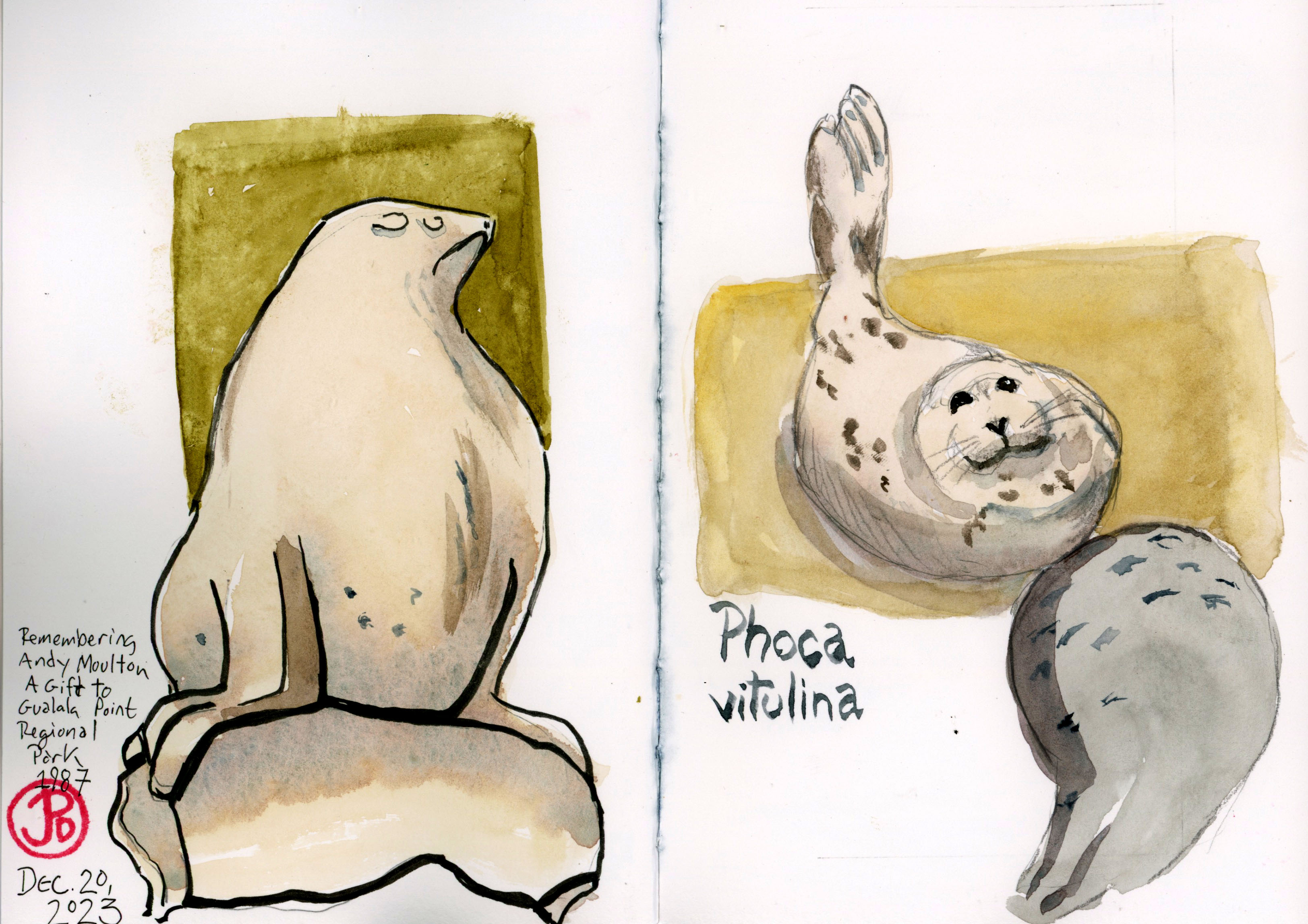
These are the harbor seals (Phoca vitulina), that use the coves as a rookery to raise their young as well as using the beaches as haulout sites to rest.

The harbor seal has the widest distribution of any pinniped (eared seals, walruses, and true seals). The harbor seal is a true seal while the California sea lion is an eared seal.

I took advantage of a midafternoon clearing in the rain to do some pinniped sketching. I started at the Shell Beach parking lot at 3:30. The gates closed at sunset, which was at 4:56, so I would have a limited time to sketch before getting back to the car in time. I didn’t want to get locked in!

From the parking lot I made it to the T- junction with the Bluff Trail in 12 minutes. I turned right and headed north in search of resting seals.

I headed out to the point at Shell Beach, the wind threatening to dislodge my hat, and once I made it to the fence, I looked down.

Seals! Harbor seals hauled out on the rocky beach. I was about 30 yards away from the seals and only one looked up and eyed me with large, dark eyes, before returning to rest. These seals were not disturbed by my presence. Which is a testament to the respect that Sea Ranchers have shown to generations of seals over the decades.

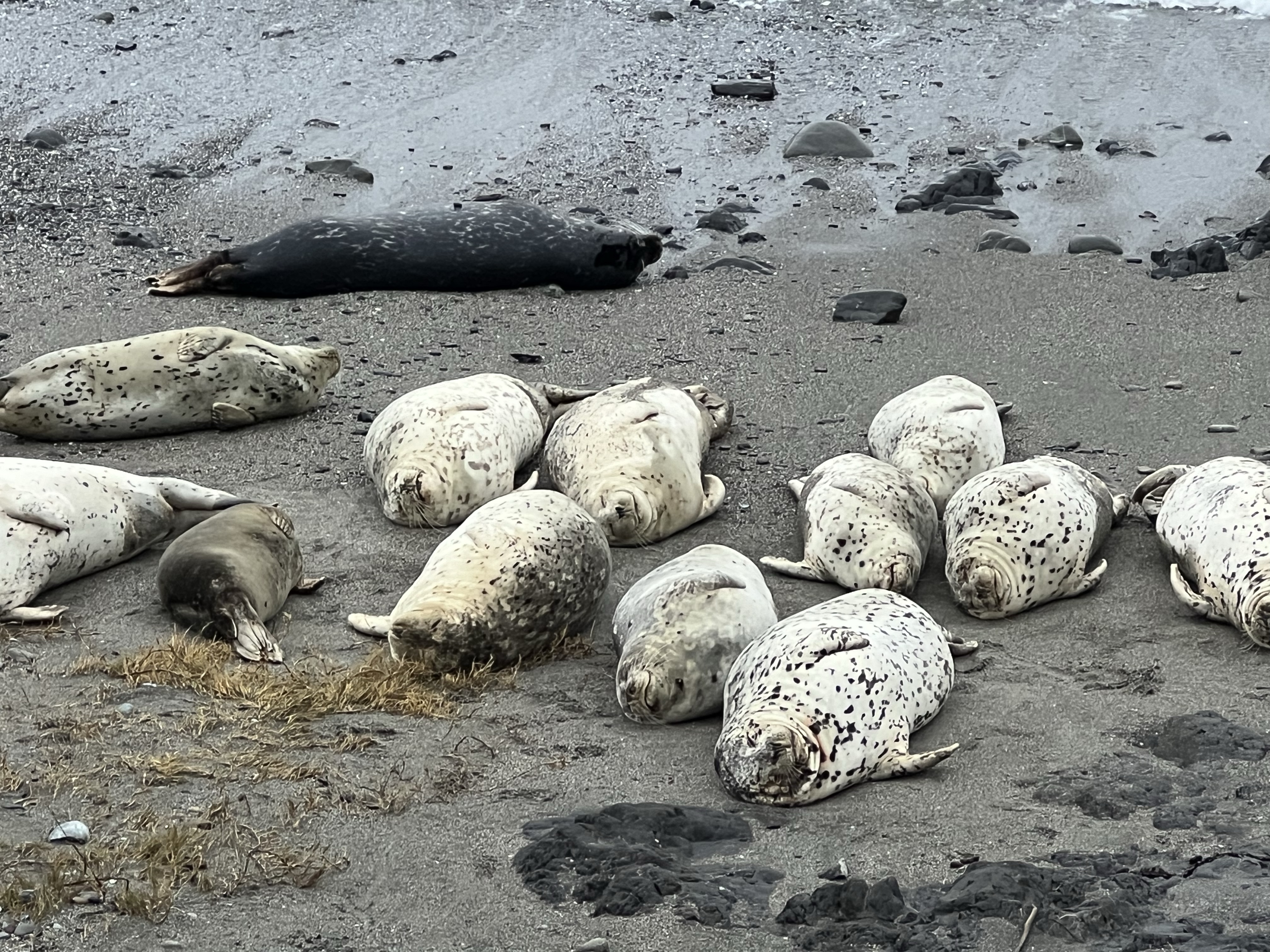
I took out my journal, using my clips to keep the pages open in the wind and started to sketch the seals. They were good subjects because they rarely moved.

The challenge was to give the impression of the number of harbor seals without making them look like logs! I hope I succeeded! (Featured sketch).

The only California sea lion I saw was a statue in Gualala Point Regional Park. So I sketched it.

Image

Recreating at The Sea Ranch

While hiking, fishing, biking, boating, birding, and nature loafing are a popular recreation activities for early Sea Ranchers, they also needed a center to swim and play tennis (and currently, pickle ball).

To this end, three recreation centers were designed and built. The three centers are: Moonraker (1965), the Ohlson (1971), and the Del Mar (1996) Recreation Centers. All the centers where designed in the Sea Ranch style: sloping roofs, barn-sided, and harmonizing with the natural landscape.

There was also function to their forms as the constant prevailing northwestern winds were an environmental impediment to recreating. To this end the architects use of berms and wind-breaks were used to shield the cold winds from the wet, bathing-suited Sea Ranchers.

I wanted to sketch them and I started with the first rec center ever built at Sea Ranch: Moonraker.

It was raining rather vigorously so I sketched the exterior from the shelter of my waterproof sketching blind aka my car (featured sketch).

The Moonraker is an innovative design. The changing rooms are a long, henge-like building which shelters Sea Ranchers from the northwestern winds. The pool and tennis courts are sunk into the landscape, providing an oasis from the prevailing Pacific gales.

The men’s changing rooms at Moonraker. The graphics were designed by Barbara Stauffacher Solomon. The work that she did at Moonraker are considered to be the genesis of the Supergraphics movement.

My next experience with a rec center was more immersive. This was at the second rec center built at Sea Ranch: Ohlson Recreation Center.

With my rental I had access to all three rec centers and I wanted to take a dip at my favorite.

Wow, what a face this presents to the wind. To the right are the tennis courts and as at Moonraker, the structure provides a wind break.

This is the Ohlson Recreation Center. I have always appreciated the design of this center since the first time I saw photographs of it, I’ve loved it. It looks like a futuristic barn that has been on the land for centuries.

I checking in, headed to the door marked “M” and converted into bathing attire. On this cold winter’s day, the heated waters of the wallowing end was perfect.

I thought doing the back waddle in the wallowing side of the pool was a perfect way to enjoy the lines, angles, and surfaces of this iconic Sea Ranch structure. Too bad my sketch book was back in the changing room (and not entirely waterproof!).

A little presoak sketch of the fabulous recreational barn that is the Ohlson Recreation Center, completed in 1971.
Image

Sea Ranch and Lawrence Halprin

One of the leading lights of the development of The Sea Ranch on the northern Sonoma County Coast was Lawrence Halrprin (1916-2009).

A ten mile stretch of coast (formally a sheep ranch) was purchased with the intention of building a community that did not fight against its location but became part of it. The placement of houses and the design of the architecture was intended to mimic the shape of the hills, meadows, and tree lines of the location.

Halprin was hired on to develop the master plan for The Sea Ranch. This was a tall task to develop a new cultural utopia, even a blueprint for all future development. This was a chance to create a new architectural language that could be translated to other locations.

I connect with the works of Halprin in many ways.

I love the way the land becomes the centerpiece of The Sea Ranch. I can’t wait to sketch it, again!

I also love to look at the sketches of Halprin. He thought in sketches of pencil, ink, and watercolor. Halprin captured the landscape in his sketches. He spent a lot of time at Sea Ranch and he had a house here.

Halprin’s words live on in the Sea Ranch Lodge.

The Sea Ranch is a touchstone that I return to for inspiration, quiet, and sustenance. I love being here and sketching here.

When my father died I retreated to the Sea Ranch Lodge to have some quiet time and write my comments for his celebration of life ceremony.

For the feature sketch I attempted a mild, if not failed, caricature of Halprin donning a barn-sided suit. In the background is his studio at The Sea Ranch where he worked while he was on his land at The Sea Ranch.

The above sketch of the house next to my Sea Ranch rental demonstrates some of the Sea Ranch principles in design. The sloped roof, facing into the wind provides a wind-break on the lee-side of the structure (to the right). The house is also sided in natural vertical wood, reflecting the barn influences of some of the first structures on the land. There is also the influence of nearby Fort Ross and it’s chapel.

What is not reflected in the Utopian plans of Sea Ranch was the view from my front room. The original design called for open views across a common meadow to the ocean. From my wall of windows I could see a golf links, a road, a line of house and finally, just beyond the houses, the Pacific Ocean.

Like the name implies, Utopias don’t always live up to their founder’s vision.

And there are always more people with more money than sense to come along and screw it up!

Image

Fort Ross, A Sketcher in the Rain

As my north coast journey approached I looked to the weather forecast of the Sonoma Coast, one weather phenomenon dominated: rain.

I wasn’t going to let this dampen my field sketching mojo. I planned to sketch at Fort Ross, no matter the weather. Call me the postal worker of sketching! Corvids don’t mind the rain.

I had everything I needed for wet weather: rain jacket and pants, umbrella, and a dry bag for my journals.

A November 2015 sketch of the Fort Ross Chapel in better sketching conditions.

Fort Ross is one of those coastal sketching touchstones that I have returned to again and again. This was the first time I had visited with 100% humidity.

Now you can’t have watercolor, as the name implies, without water. But a deluge of rain is a bit too much water. And applying ink to damp paper will cause the ink to run or smudge which can become part of the story of the final sketch.

Now this bed just looks icy cold.

Visiting Fort Ross on a cold, rainy, and windy day gave a me a first hand experience of what it must have been like to spend the winter at the fort. It was dark in the houses even in the middle of the day. No electricity, no television, no smartphones, and no emojis. Cabin fever anyone?

The plus side is that I had the fort all to myself!

The Russians added some new species to the scientific record, of course they couldn’t tell the native people something they didn’t already know.

I knew the perspective I wanted to sketch from: along the barricade looking west toward the guard tower. Seems perfectly fine while you’re planning in your cozy abode; far harder to do in the realities of rain and wind.

I had my umbrella to keep the rain off my journal. Well my umbrella was absolutely useless in these fierce coastal gusts. Trying to concentrate on my sketching while attempting to prevent my umbrella from launching into the local watershed was a struggle.

I had to abort the sketch without actually committing pen to paper. It was time to find shelter from the wind and the rain and commit a sketch to my journal.

I chose as my sketching blind, the second story of the Kuskov House. Great view, dry, and less chilly.

Call me a cheater but by hook or by crook, I got my rainy day sketch in under the timbers of the Kuskov House.
Image

Column Snake, Stanford

On a Saturday morning Grasshopper and I headed to Stanford to do some field sketching and we found ourselves in front of the university’s latest public art.

This piece is an extended Corinthian column rearing up to look like a cobra about to strike. It bears the all too prosaic title of “Hello”. It was completed in 2021 by Xu Zhen.

I would think a better title for the sculpture would be “Column-Snake of Death” or “Columnar Churro of Doom” or even “Goodbye!”.

The column snake seems to tower over Hoover Tower.
Grasshopper Sparrow sketching Hello.
Another perspective and another sketch.
Image

Tanforan Siding

The former racetrack at Tanforan is bordered on one side by the former Southern Pacific mainline (currently used by the passenger service Caltrain).

Heading south, the line joins the wider rail network at Santa Clara and San Jose and on to all points on the National railroad compass.

The rails are still very much in use as a northbound Caltrain heads to San Francisco. The train is being pushed by locomotive EMD F40PH-2 No 905 “Sunnyvale”. These diesel-electric locomotives will soon be replaced by electric train sets.

Tanforan was, therefore, connected to the nation through the siding track that brought cars from Tanforan Park proper, to points north (San Francisco) and south (San Jose).

The Tanforan Siding heading towards the former racetrack (now Tanforan Shopping Center). This is the track that connected the siding near the backstretch with the rest of the rail network.

In 1938 the famous thoroughbred racehorse Seabiscuit boarded a special horse baggage car at the Tanforan Siding and he was shipped across the country to the East Coast on his first attempt to beat War Admiral. Large crowds came to see Seabiscuit off at the siding. The first meeting of these racing heavyweights did not happen.

Tanforan does have a dark past. In 1942, the racetrack became the Tanforan Assembly Center (the only assembly center in the San Francisco Bay Area). After the attack on Pearl Harbor, President Franklin D. Roosevelt issued executive order 9066. As a result Japanese Americans where rounded up and about 8,000 men, woman, and children where brought to Tanforan Racetrack now newly christened the Tanforan Assembly Center (one of twelve assembly centers on the West Coast).

Two-thirds of the detainees were U. S. Citizens, born and raised in the United States.

The Tanforan Memorial outside the San Bruno BART Station. The sculpture is based on a 1942 Dorothea Lange photograph of a family on their way to Tanforan. The memorial was dedicated on August 27, 2022.

The first internees arrived on April 28, 1942. They were housed in barracks and horse stalls that reeked of manure and urine. Some families spent about eight months here before being transported, over rail, to the Topaz War Relocation Center in Utah where they remained until the end of the war.

By the fall, the detainees were being sent on a two day rail journey to the Topaz War Relocation Center. On September 9, 1942, the first group of 214 detainees entered the siding that Seabiscuit travelled on a few years earlier and entered the mainline for their trip to the wastes of northeastern Utah. On October 13, 308 detainees, the last to leave Tanforan, entered the siding and then on to Utah.

The Tanforan Assembly Center was now closed.

The site of the former track and assembly center is now a shopping mall.

In 2022 the mall was bought by a developer and there are plans to raze the mall and build a massive biotech campus.

Image

Fort Humboldt

Who knew that the Northern California town of Eureka had some Civil War and presidential history?

Such is the case when a young captain who served at the fort for five months. He was a loner and spent his free time in local taverns and riding in the countryside. It is said that he developed a taste for whisky while at Fort Humboldt. His name was Ulysses S. Grant.

Of course he went on to become a Civil War hero where he commanded the Union Army. It was Grant that Robert E. Lee surrendered to at Appomattox Courthouse on April 9, 1865.

Grant later served as the 18th president from 1869-1877 serving two terms.

There are not many original buildings left at Fort Humboldt but here is where the commissary once stood. Grant served as the fort’s quartermaster, probably at the commissary.

There is not much left of the fort on the bluff above Humboldt Bay and the fort hospital is the only remaining structure of the fort period (from 1853-1870). I pulled up my sketching chair and sketched the hospital building on the left of my spread. On the right is one of the largest steam donkeys ever made.

The state park has some nice relics of the lumber era that put Humboldt County on the economic map.

Image

Northwestern Pacific’s Eureka Slough Bridge

It was a cold, clear, and crisp morning in Eureka, a perfect day for railroad sketching.

Pre-trip, the Northwestern Pacific bridge over Eureka Slough was high on my sketch list. This bridge has had a major rebuild at least once and now looks to be in good shape

I pulled onto Y Street, any further north and I’d be in Arcata. At the end of the street is the rusted railroad and pedestrian path that follows the shoreline (The Waterfront Trail). I headed right on the trail (north) to where the path comes to the slough and then heads east. Of course the railroad proceeded north by conquering Humboldt Slough with a bridge. And that’s what I was here to sketch.

I had thought about bringing along by sketching chair but when you have the Steam Engine Bench with a capital view of the slough and bridge, why bother?

The Steam Engine Bench has to be one of the best sketching seats I have ever sketched from!

It was a beautiful morning to sketch and my pants absorbed the wet bench. I had to use a lot of sketcher’s shorthand and leave off the vast amount of graffiti that the bridge was covered in. I did keep the words, “OLD CROW” painted into seven panels of the bridge.

The bridge looking north towards Arcata which was as far as Northwestern Pacific ever reached.
Sketched from life!
Image

Diamond Springs Creamery, Loleta

I love sketching old abandoned historic buildings. And if they were featured in sci-fi horror cult film, even better.

The Diamond Springs Creamery was built in 1893 in Loleta, California. Which is about 20 miles south of Eureka. The location of the plant would make sense because it is in the middle of California Coastal cow country and on the route of the Northwestern Pacific mainline, bringing dairy to points south including San Francisco.

The dairy plant is very large, perhaps three blocks by six blocks. A good portion of the town must have worked at the plant making Loleta a real company town.

Now the brick building is falling apart with broken windows and covered in graffiti. It was in operation for over one hundred years, stopping production in 2007 and finally being abandoned in 2010. It is now surrounded by a fence with many “No Trespassing” signs on display. This must be to keep graffiti artists and film geeks at bay.

The slowly crumbling milk plant.

In 1982, Loleta filled in for the fictional town of Santa Mira and the creamery stood in for the Silver Shamrock Novelties factory in the film Halloween III: Season of the Witch.

While the film made a profit, it was the lowest grossing film in the Halloween franchise. It probably shouldn’t have been called Halloween III because it gave the false expectations that it was going to star a man in a doctored Captain Kirk mask with a large knife. This film does feature masks but not Michael Myers.

Screen shot of the creamery plant decked out as Silver Shamrock Novelties from Halloween III: Season of the Witch.
Another angle of the creamery. The structure on top once displayed the Silver Shamrock logo.
Image

Eel River Canyon

One of the biggest challenges of building a railroad from Willits to Eureka is the Eel River Canyon. And the Northwestern Pacific Railroad (NWP) definitely had their hands full with this engineering challenge.

Parts of the NWP mainline is still in use as the Skunk Train pulled onto the mainline at the Willits Depot. Unfortunately the Skunk is heading in the opposite direction of Eel River Canyon. (For very good reasons).

13 miles north of Willits the Northwestern Pacific (NWP) line crosses Highway 101 and begins to parallel Outlet Creek.

The rusted rails of the NWP heading north towards Eel River Canyon.

Just north of Willits I turned left onto Highway 162 (Covelo Road). I wanted to follow the railroad as far north up the Eel River Canyon that I could. I figured I would get as far as Dos Rios before I ran out of road.

There were some key sites in the Eel River Canyon that I wanted to see: Cain Rock and Island Mountain but these were so far off Highway 101 on long and windy roads (some on private roads that seemed very inaccessible). I wanted to avoid trespassing in Mendocino or Humboldt Counties! (Think shotgun!)

One of my sketching destinations was the train trestle over Outlet Creek near the confluence of the creek with the Eel River.

I pulled over just as I crossed the Eel River and set up my sketching chair to add the trestle in my Beta panoramic book (featured sketch). The field sketch is on the left side and as the pictures moves to the right, the color turns to sepia and a steam locomotive pulling a passenger consist, is heading down canyon towards the trestle. The spread is a look back in time.

After the sketch I continued to follow the line towards Dos Rios on Highway 162. I came upon a tunnel, NWP Tunnel 14.

Tunnel 14 in the Eel River Canyon.
This photo shows one of the problems with keeping the line open, both then and now. Here a landslide has covered a large section of the track. Think how expensive it would be to stabilize the hillside and reopen the line. This is one of many slides along the canyon.