Image

PDX

Before returning to the classroom I took a final summer road trip that took me up north to the state of Oregon, with a slight dabble into Washington.

Ashland, Portland, and the Oregon Coast were all destinations on the  1,824 miles I logged on this journey . In two sketchbooks I completed 22 sketches in the week I spent in the Beaver State (in truth two sketches were done in Northern California).

The three sketches included in this post are all field sketches from Stumptown, or Portlandia, or P-town, aka The City of Roses: Portland, Oregon.

PDX 2

Line sketch of Portland’s iconic Union Station Tower, on the west bank of the Willamette River.

PDX 3

The lumberjack (circa 1959) that is the sentinel of North Portland (NOPO).

Image

Monterey Orcas

As part of the Guild of Natural Science Illustrators Conference at UC Santa Cruz a group of illustrators set out from Moss Landing Harbor on a Thursday morning for a three hour tour.

Monterey Bay is known for its pelagic birding and the many marine mammals that enter the bay throughout the year. The reason for this lies under the waters. Starting just off Moss Landing’s shores and stretching out to the west for 95 miles, lies the Monterey Canyon. This submarine canyon is larger than the Grand Canyon reaching depths of 11,800 feet and is the largest submarine canyon on the west coast. The deep waters provides a nutrient rich feeding ground for birds, fish, sea turtles, and marine mammals which includes the largest animal on planet earth, the blue whale.

I had first seen blues in the bay on a whale whatch trip out of Monterey when I was a junior in high school (to the disbelief of my biology teacher, but I had the pictures to prove it). It was not uncommon to see gray and humpback whales in Monterey Bay. But on this trip I was going to see a life marine mammal in the wild!

The first marine mammals we encountered in the harbor were sea otter, harbor seal and California sea lion. We turned to the portside at the foraging white pelicans and headed out of the break water to the open ocean and the Monterey Canyon.

It wasn’t long before I spotted our first marine mammal, a lone harbor porpoise (they always seem to be alone), crossing our western bearing, heading to the north of the bay.

After about 15 minutes our captain spotted a blow on the horizon and off we went to find the source. We caught up to the whale, a young humpback and were treated with nice views of its flukes as it dove down. We followed the whale and watched it resurface, take a breath and dive again. We then spotted another humpback and followed it.

Murmurings from the cabin let me know that something was afoot. The captain was on the radio with another whale watch boat and it seemed that they had just sited something special in the southern part of the bay.

As we throttled up heading on a southern bearing, scattering sooty shearwaters in the process, I knew it could be two things: a blue whale or an orca pod. I was hoping it was the latter! Our naturalist was keeping quiet about the sightings to the south.

My first experience with live orcas or killer whales, happened not too far from my childhood home. It was just north on Highwsy 101 on the western rim of San Francico Bay. The setting was the ambitiously titled Marine World Africa USA in Redwood Shores. This amusement park’s main draw, aside from the water skiing show, was the killer whale show where the world’s largest pied dolphin swam in circles and leapt up to snatch a herring from the trainer’s mouth. This is the way most children fell in love with killer whales in the last 1960’s and 70’s.

Since that time, attitudes have changed about keeping these magnificent marine mammals in captivity and training them to do tricks for eager audiences. Marine World left it’s original site on the west side of the bay in 1986 and moved to Vallejo later to be renamed Discovery Kingdom. The amusement park sent it’s last captive orca to San Diego in 2012, ending 40 years of orca captivity at the park.

I now wanted to see orcas in the wild, orcas swimming in a straight line, orcas not doing tricks for an audience. And hopefully we would be seeing a pod soon. We arrived at a location just off the coast of Monterey where there was five other watching boats in pursuit.

DSC06382

Part of the pod whale watch boats following the pod of orcas. Here a female breaks the surface.

There was a moment of anticipation as we scanned the waters, willing every wave or shadow to materialize into the black back of an orca. Soon we were rewarded with a pod of about seven orcas consisting of females and calves. Two came within ten yards of our boat to give us a look-see!

Recently more and more orcas have been sited in Monterey Bay. It was previously thought that they appeared during grey whale migration to prey on mothers with their calf as they headed north from their birthing lagoons in Baja California to head to their feeding grounds to the north. But now they can be seen throughout the year.

GWhale

A sketch of a grey whale and calf from the Seymour Marine Discovery Center in Santa Cruz.

Image

Coloma, again

This summer I returned to Coloma and the Marshall Gold Discovery State Historic Park sans 90 fourth graders. I had two historical buildings that I wanted to sketch: the Coloma schoolhouse and Wah Hop Store.

I headed to Coloma from my mother’s house in Penn Valley, early in the morning, to avoid the oppressive heat of the foothills in summer. Even though the spread makes it look like the school and Chinese store sit right next to each other, they are on opposite sides of the the town. I just used my artistic license (it hasn’t expired just yet).

The original school burned down and was replaced by the abandoned Slatington School which was nine miles away and moved to it’s present site. The school was reopened in January of 1920.

IMG_4899

Painters painting the school as I am painting the Coloma school. The ranger came by to inspect our work.

After sketching the school and store, I headed up the hill to sketch one touchstone that I keep returning to, the James Marshall Monument.

Age of Gold

I filled in the page with the last two paragraphs of H. W. Brands seminal work The Age of Gold. This book, along with J. S. Holliday’s groundbreaking masterpiece, The World Rushed In, are the two greater books written about California’s Gold Rush. the last paragraph of Brands history is quoted here:

Yet he was remembered after his death, and a statue was erected in his honor. The statue stands above the river at Coloma, in a hillside copse of trees. From a stone pedestal Marshall gazes out across the valley. The mill is long gone, and the millrace obliterated. But so is most evidence of the hordes who followed Marshall here, and the general scene isn’t much different that it was on that sunny, cold morning in 1848, when the carpenter’s eye fell on the glittering yellow flakes that set the heart of the world aquiver.

Image

4,000 Year Old Tree and the Invisible Vireo

This summer I returned to the Eastern Sierras, the Owens Valley, and the White Mountains. I had two objectives for my visit:

  1. To finally head out to the White Mountains to hike among the 4,000 year old trees at Ancient Bristlecone Pine Forest.
  2. To search for the elusive plumbeous vireo and add it to my lifelist.

The bristlecone pines where the easier of the two objectives because they hadn’t gone anywhere since the time the Egyptian Pyramids where completed. The vireo was an altogether different story.

I lit out of Bishop  to the White Mountains early one morning, first heading south on 395 and then east at Lone Pine. The road to Bristlecone Pine is only open when the snow melts, which explains why I had never made it out on my Spring visits to the Eastern Sierras. About an hour later I arrived at 10,000 feet at the Schulman Grove Visitor Center.

The visitor center and grove are named after Dr. Edmund Schulman (1908-1958) who was an early pioneer of dendrochronology, which is the study of tree rings to determine past climatic conditions. Schulman was determined to find the oldest living trees by taking a core sample and counting the rings. In 1953, this search brought him to the White Mountains and the groves of Bristlecone Pine ( Pinus longaeva). He first took samples from one side of a drainage but then moved across the valley to the other side which consisted of more arid rocky dolomite soil of the eastern facing slope. Here in the grove that now bears his name he took a core sample of an old specimen. He returned to his camp and he started counting and counting and counting. He was amazed to count rings beyond the year 2046 BC! He had discovered the first tree that was over 4,000 years old.

A few years later and a few miles away from the Schulman Grove he discovered the Methuselah Tree, which is believed to 4,600 years old, the oldest living thing on planet Earth. The Methuselah Tree’s exact location is kept a secret to prevent vandalism.

Schulman’s work  and the work of other dendrochronogists have pieced together a continuous bristlecone tree chronology both of living and dead wood. This has provided information about climatic patterns over the last 11,500 years and has helped modern historian date ancient objects, such as Stonehenge, more accurately. Bristlecone pines have been called “the trees that re-wrote history”.

My second objective was to find a small gray bird at the very western edge of it’s range. I had tried to find this bird on many trips to the Eastern Sierras without success. But this time, with the help of ebird, I was able to find two locations around Mammoth Lakes where the vireo had recently been seen. The two  location were the Earthquake Fault Trail and the Inyo Craters.

On one afternoon I headed up to the Inyo Craters. The skies clouded over and ominous dark gray clouds rolled in from the northwest. A typical late afternoon Sierra thunder storm. The thunder and lighting was close and I aborted my search as I heard a vireo-like warble coming from the ridge. On my hike back to my car I was pelted with chick-pea sized hail. I was left with a memorable memory but without the plumbeous.

My second location was the Earthquake Trail. Instead of searching I decided to find a quiet sit spot snd just let the birds come to me.  I chose a stump that faced down hill into the pine forest. While I did not find what I had come to find, as often happens, I found something unsuspected: an active woodpecker nest cavity in a snag just down hill from my stump. It was the uncommon Williamson’s sapsucker, the woodpecker that Pete Dunne calls “The Beautiful Sapsucker”. So of course I did a spear about the finding.


WSapsucker

Williamson’s sapsucker nest cavity at the Earthquake trail.

I never did find plumbeous vireo. This bird has become a juju bird for me. I guess it just gives me a reason to return to the Eastern Sierra to continue the search.

On Top Devils

Another visit and sketch of Devils Postpile but this time on top of the pile.

Image

The Valley Part 4

There was yet another birth in 1971 in the Santa Clara Valley that played into the history of personal computing. This was a new performance arts center on the campus of De Anza Community College in Cupertino. It was dedicated in the year of my birth and it was christened: Flint Center for the Performing Arts.

In my personal history, this 2,600 seat auditorium had been the location of a few field trips and an occasional performance of The Nutcracker around the holidays. The set up of the auditorium is with seating front and center with two side aisles, but without  a center aisle. Perhaps not the best design for a patron with a weak bladder!

After High School I attended De Anza and I even took a film class in the back of Flint Center.

What writes Flint Center into the digital annals of Silicon Valley history was what occurred here on January 24, 1984. In this ominous Orwellian year, a company that started in a garage in Los Altos, was going to take on the Davids of the computing world with the introduction of their new computer. The company would be Apple Computers and it’s new product, which was launched here at Flint Center, was named the Macintosh.

Flint Center was chosen as the sight of the annual stockholders meeting and the Mac team walked the short distance to the auditorium from their building near De Anza Boulevard.

The auditorium was packed in anticipation for Apple’s new computer. The fervor was stoked by the Riley Scott directed ad that was shown during the third quarter of Super Bowl XVIII. The now famous “1984” ad depicts a dystopian world where mindless drones march in lock step and a hammer wielding woman runs toward the screen thats projecting “Big Brother”. She throws the hammer at the screen and the drones stare on in opened mouthed awe as the screen explodes. The ad ends with he words, “On January 24th, Apple Computer will introduce Macintosh. And you’ll see why 1984 won’t be like “1984””

Steve Jobs, as chairman, opened the meeting by quoting the second verse to the Dylan song, “The Times They Are a-Changin'”. He then unveiled the machine that he knew would change the world.

In the late 1980’s our family owned a Macintosh SE. I liked the design on the computer and the warm and friendly fonts and designs. But soon after that, Apple computers moved outside of my price range.

Flint Center was used for two other Apple events and the performing arts center has been used as a filming location for two of the three films made about Jobs since his death in 2011.

IMG_4799

Here is the “birth certificate’ of Calvin Flint Center of the Performing Arts.

Image

The Valley Part 3

  • 1971

That year was a year of two births in Santa Clara Valley. One was in  the wee hours of August 31st at El Camino Hospital in Mountain View. And the other was on January 11th. The former was my birthdate and the latter was the first time Santa Clara Valley was rechristened Silicon Valley in print. A columnist named Don Hoefler wrote a column in Electronic News titled “Silicon Valley USA”, in reference to the growing number of companies producing microprocessor chips. And since then, the moniker has stuck.

Five years earlier a family moved from Mountain View to a 1952 single story ranch house that was built on the site of a former orchard in Los Altos. The house is owned by the Jobs family and the address of the rather plain house is 2066 Crist Drive.

When I pulled up opposite to the house on Crist Drive there were already three tech tourists in front of the house. A 20 something from Arizona taking  pictures of his girlfriend in front of the driveway and a bespectacled long-hair that looked like he was visiting a sacred shrine in Japan.

And in a sense, this is a shrine to those who worship at the alter of Apple Computers and is beatified co-founder, Steve Jobs.

The house at 2066 Crist Avenue and more specifically, it’s garage, was the birthing place of Apple Computer. It was here that Jobs, Steve Wozniak, and family and friends assembled the first 50 Apple I personal computers. The garage was also the birthing location of the even more successful Apple II. (My elementary school in Cupertino had three Apple II computers which were housed in the library.)

While sketching the house I reflected how much it resembled the house where I grew up, just 3.6 miles away, which was a two story track house in Sunnyvale, also on the land of an apricot orchard. I attended the rival high school to Homestead High, where the two Steve’s graduated. In a 1995 interview Jobs commented on growing up in the area:

Silicon Valley for the most part at the time was still orchards-and it was really a paradise. I remember the air being crystal clear, where you could see from one end of the valley to the other- It was really the most wonderful place in the world to grow up.

Anyone visiting Silicon Valley today would not include the word “paradise” in their description, unless there where referring to the fecundity of Starbucks and convenient  but anonymous mini malls that speckle the valley like feed to the chickens. And as for the crystal clear air of Jobs’ youth, now you can barely see the peak of Mt. Hamilton thought the permeant haze of the valley.

I sometimes ask myself, what was lost and what was gained, in the transition from Heart’s Delight to Silicon? Has the standard of life corroded for those children growing up in the valley today? Now, can the youth of Silicon Valley share the same experiences that Jobs and myself had? And as Jobs noted, is Silicon Valley still,”the most wonderful place in the world to grow up”?

In my youth there were open fields, orchards,  and empty lots to play in. No play structures, just a blank canvas for your imagination to wander. Where do the youth of Silicon Valley go to experience nature? Or are they too preoccupied with videos games, iPhones and iPads to notice what has disappeared?

1512

A 2011 sketch of the two story track house I grew up in, 3.6 miles from 2066 Crist Drive. My father moved out of this house shortly after I sketched this and it was sold to an Apple engineer for an unbelievable amount.


Image

The Valley Part 2

When and where was the genesis of Silicon Valley? What started the charge from an agrarian valley to the world’s epicenter of innovation and technology? What was the Pandora’s box that set the change in motion?

Ironically, it was on the campus of a  university whose nickname is “The Farm”. To the rest of the world it is known as Stanford University.

It was on the Stanford campus that an engineering faculty member, Dr. Fredrick Terman, encouraged his students to start their own businesses and keep them in the Santa Clara Valley instead of joining established companies in the east coast. Herman has become known as the father of Silicon Valley. Two of his students heeded his advice and started their business in a humble garage in Palo Alto. Their names where William Hewlett and David Packard.

This garage is now known as “the Birthplace of Silicon Valley”. It was in this small detached garage, in 1939,  that Hewlitt and Packard built their first product, an audio oscillator.

Fredrick Terman also encourage the development of local businesses by convincing Stanford University to develop a 700 acre business park on Page Mill Road, just south of the campus. The park was built in 1951 and early tenants were Varian, Hewlett-Packard, Lockheed, and General Electric. The park was renamed Stanford Research Park and it is still the address of the main headquarters of the company that started in a Palo Alto Garage on Addison Avenue.

In the next post I will sketch another garage that birthed one of Silicon Valley’s most famous companies. This garage sits on land that was once an apricot orchard and the company that starting in this garage changed the face of the Santa Clara Valley perhaps more that the two Stanford grads that labored away in a small green shed in a Palo Alto neighborhood.


Image

The Valley Part 1

Silicon Valley is probably a good, in many ways. The Valley of Heart’s Delight was a glory. We should have found ways of keeping the one from destroying the other. We did not. . .

-Wallace Stegner, Pulitzer Prize-winning novelist

 The children’s book of poetry, Where the Sidewalk Ends by Shel Silverstein was a popular birthday gift at many birthday parties when I was a child growing up in the 1970s. But in the Santa Clara Valley where the sidewalk literally ended, the apricot and cherry orchards began.

Sunnyvale in the 70s was in a state of transition. It was the struggle between the Valley of Heart’s Delight and Silicon Valley. When I was a kid, it seemed that the Valley of Heart’s Delight had the upper hand, but the lone apricot tree in our back yard, told that the ascendancy of Silicon Valley was clearly underway. The apricot orchard had made way to the track homes that housed the families that fueled the early industries of Silicon Valley, and this lone tree, which my brother and I posed in for family Christmas cards, was the last reminder. My family, on Cormorant Court, was one of those early Silicon Valley families.

After work, during the final warm days of summer and fall, my father would put me on the back of his bicycle and we would retrace his route to work along Fair Oaks Ave. We ascended the pedestrian walkway over the Southern Pacific train tracks. Here we would look down into the Schuckl Cannery on the side of the tracks. To this day I can recall the din of the conveyor belts, the frenetic energy of the forklifts bringing in the valley’s harvest, and the smell of the burning train brakes as a commuter train eased into Sunnyvale Station down below.

IMG_4778

Blenheim Apricots at the Sunnyvale Heritage Orchard. This preserved orchard is on ten acres and contains about 800 trees. At it’s height Sunnyvale’s orchards included eight to nine million trees.

Then there was the oft-told story of the day my dad drove to work along Fair Oaks Ave  and he saw a cherry orchard  being uprooted, with fruit still on the trees. “What a waste” was the phrase that usually concluded the story. Those orchards are now rows and rows of condos with names like Cherry Orchard and Orchard Gardens Apartments.

Gone are the millions of apricot and cherry trees, the canneries, and the migrant workers that picked fruit each summer and fall. What is left are like islands of preserved orchards in Sunnyvale, Santa Clara, and Los Altos, a mere shadow of the agricultural area that once attracted motorists each spring to view the millions of blossoming trees.

IMG_4769

In 2001 the Sunnyvale Orchard Heritage Park Interpretive Exhibit was opened. It was built along side the Heritage Orchard with interpretive signs that told of the rise and fall of the Valley of Heart’s Delight. My father’s name is immortalized on one of the signs in the Hertitage Park. He helped to create the park so future generations would remember the valley’s past. 

On a recent returned to Sunnyvale on a May morning, that was already starting to feel like summer, I sketched a few apricot trees at the Orchard Heritage Park. On my way I drove down De Anza Boulevard, past the ghosts of my childhood, past unrecognizable buildings and storefronts, past the Apple Campus. So much was physically gone. An orchard, a favorite restaurant, a father. What does it mean when your past no longer physically exists?

Over the next few blogs I will explore the changing face of The Valley.

Image

Redwood Deck

At my cabin in the Santa Cruz Mountains, the redwood deck that faces northwest, over the San Lorenzo River and the hillside of trees beyond, has become a touchstone for my journaling. This view and this amphitheater has inspired many sketches.

I have sketched this scene over the years in many different seasons and in different light. This view has helping me focus on the natural details that surround the cabin. I have found that by looking at a single location, the possibilities are infinite.

Many different animals visit the deck and the area around it. Chickadees, juncos, jays, nuthatches, acorn woodpeckers, black-headed grosbeaks, wood ducks, Cooper’s hawk, red-shouldered hawk, band-tailed pigeons, squirrels, deer, raccoons and skunks. All these creatures have found their way into my journals.

Chickadee tree

The redwood tree, that towers over the cabin, off to the right has been the inspiration for a dozens of sketches. I built a chickadee nest box that hangs about 30 feet above the ground. The actives of the chickadees during the spring and summer months have always been fodder for my musings. The above spread was done on Mother’s Day.

Jay ladder

For some the “blue jay” of the redwoods is a noisy egg thief that is abhorred but to me the Steller’s jay provides hours of entertainment. The page above is from observing the jays as they bounce up the “Redwood Ladder” after getting seed at the feeder.


Swainson's thrush

On a resent May afternoon I was greeted by the ethereal call of the Swanson’s thrush coming from down the hill on the near shore of the San Lorenzo. This neo-tropic migrant had returned to it’s summer nesting grounds. I created a spread to celebrated it’s arrival with a portrait, a map, and a bust of William Swanson, the British ornithologist that the thrush is named after.

Image

Grinding Rock, Coloma

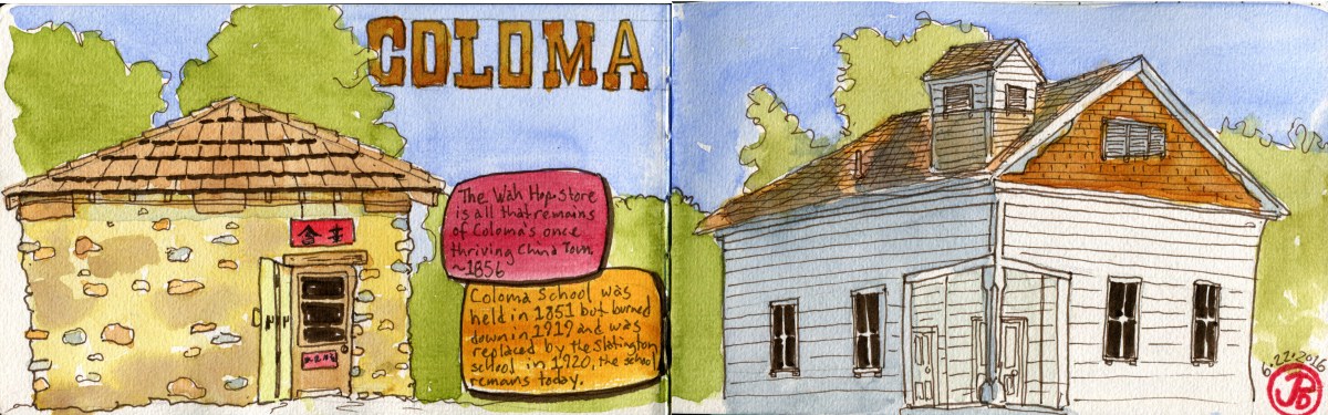
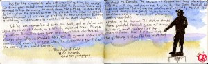
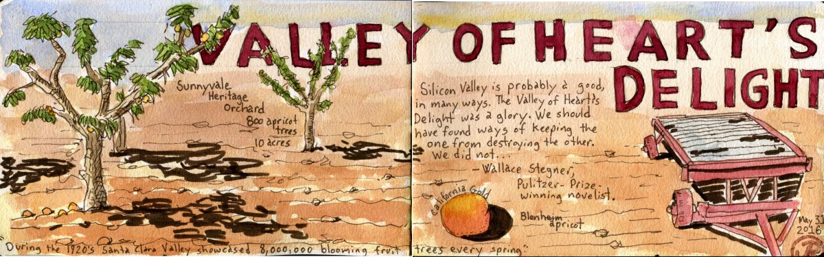
This May I organized and participated in the biggest event in any fourth grader’s life at my school. Our annual three day, two night trip to the Coloma Outdoor Discovery School (CODS). My school has been part of this program for 23 years and CODS had just celebrated it’s 25th anniversary.

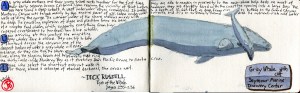
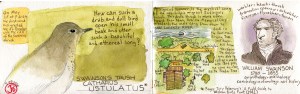
Coloma is the site of the event that changed California’s and the Nation’s history. In January of 1848, a carpenter from New Jersey, named James Marshall, spotted something shining in the tailrace of the sawmill where he served as construction superintendent. This was the “discovery” of gold that led to the Gold Rush of 1849, which is cited as the largest mass human migration in human history. California would never be the same. Just like my Greenhorns would be forever altered in their three day journey from being a Greenhorn to  becoming an experienced Sourdough miner.

The CODS campus  lies on the banks of the South Fork of the American River, just upstream from the site where the carpenter’s eyes fell on the shining beacon of gold. We are literally living in history, in a location that was ground zero for the enormous flood of emmigrants and immigrants that transformed the Golden State.

Each morning I would head out of my digs with my journal and paints. In the early morning, nature returns to the campus. The first harbinger of the dawn is the California towhee, with it’s emphatic “cheep” call. It is soon followed by the contact call of the California quail, then the harsh reprise of the western scrub-jay (Aphelocoma californica). Coloma is a place of truly California birds. When I stepped out of my door a covey of quail was to my left and six black-tail deer was to my right. The space in-between was populated with Canada geese and their downey goselings. The “wake-waka-waka” call of the acorn woodpecker was coming from the trees above.

I turned left, the quail scuttled off to the brush and I headed downstream  with no destination but an urge to capture my experience in ink and watercolor. To my right was the American River, the river that Sam Brannan emoralized on May 12, 1848, when he held aloft a bottle of gold dust and announced to the crowded San Francisco street, “Gold! Gold! Gold from the American River!”

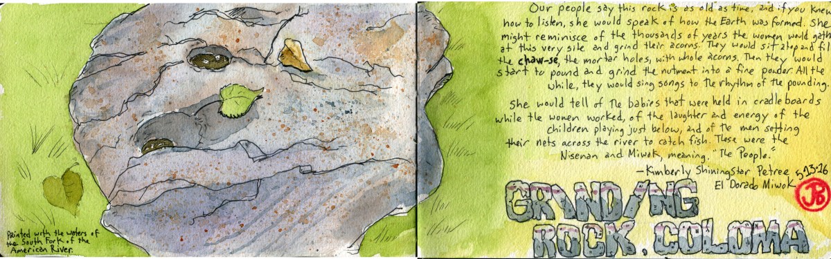
I headed out to the very edge of campus, just shy of Troublemaker Rapids. I saw a pieced of exposed granite surrounded by grass. I had not seen his rock before. Two mortar holes were worn into the granite. These holes were created and used by the native people of Coloma Valley to pound acorns into meal.

Acorns were a valuable food resource to native Californians providing protein and carbohydrates as well as a source of vitamins A and C. The grinding rock was silent now. The ancient grinding songs are gone but the sound of the swollen river working its way through Troublemaker Rapids and the calls of acorn woodpecker and scrub-jay, the other inhabitants of Coloma Valley that use acorns for sustenance, remain.

I set down my paints and journal and walked to the banks of the American and filled my cup with the icy snowmelt. I returned to the grinding rock and I started my sketch.

DSC06325

Sketching the grinding rock on the CODS campus with the waters of the South Fork of the American River.

Tree of Heaven

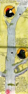
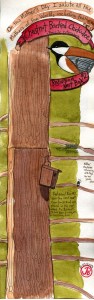
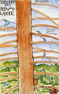
My second sketch was found much closer to my digs, across the dirt road in fact. Like the thousands that rushed into Coloma Valley in 1848 and 1849 this was an invasive species. It is known by many derivative monikers. My favorites are “stink tree”, “ghetto palm”, and “tree of Hell”. It is known to science as Ailanthus altissima, and it’s common name is tree of heaven. It’s native home is the celestial kingdom: China.

The tree was brought to California in the 1890’s by Chinese immigrants, who sought their fortune in the gold fields. It is commonly found in abandoned Chinese mining camps.

What really interested me was the two active cavity nests that were in the upper reaches of the truck. The bottom cavity was being used by a pair of European starling. Each time the adults returned with food, the begging calls of the chicks could be heard from the front porch of my digs. The upper hole was occupied by acorn woodpeckers.

For me this tree and it’s tenants are a metaphor for Coloma and California since the time of the Gold Rush of 1849. Here was a tree from Asia being occupied by an evasive species of bird, the European starling that has spread in it’s own Manifest Destiny, from coast to coast and north and south. Just when these thoughts get me down, the Acorn woodpecker returns to her nest with a beak full of insects for her hungry chicks. This is the true native Californian, occupying the upper nest cavity. Her brood will ensure that the laughter-like waka-waka-waka call of the bird that the miners call carpentero, will always fill the Coloma Valley.