Image

Sketching on the Helipad, M*A*S*H Part 2

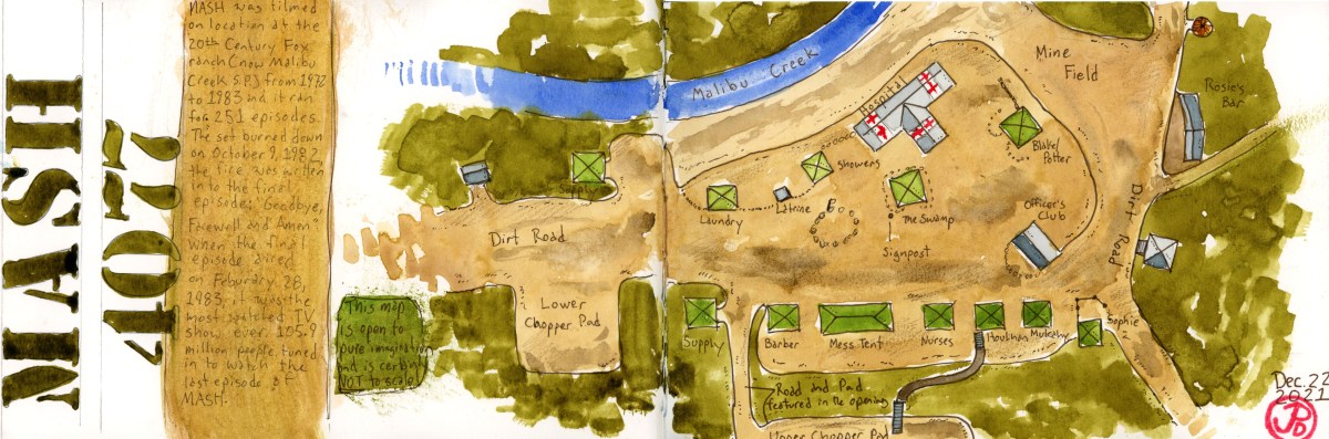
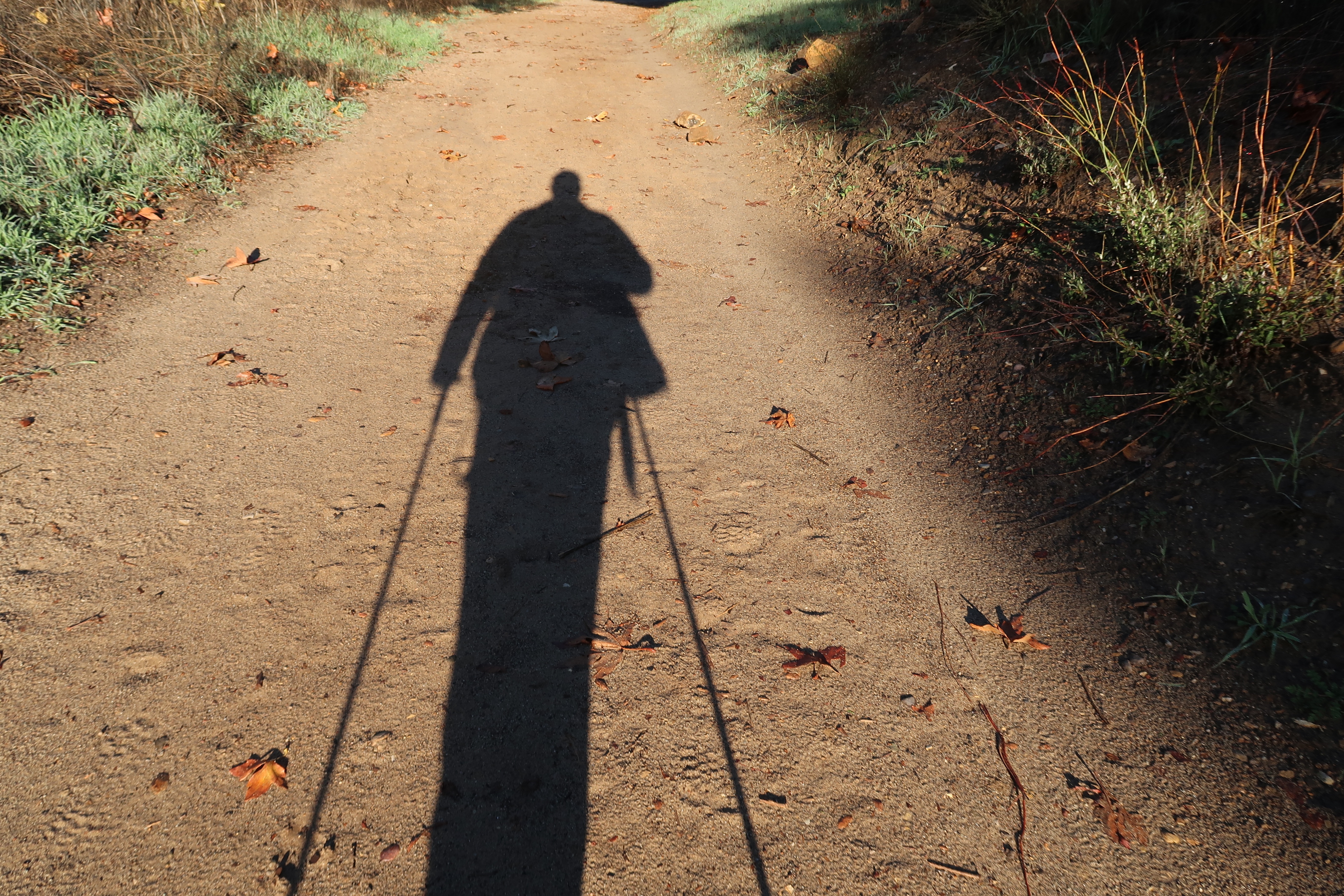
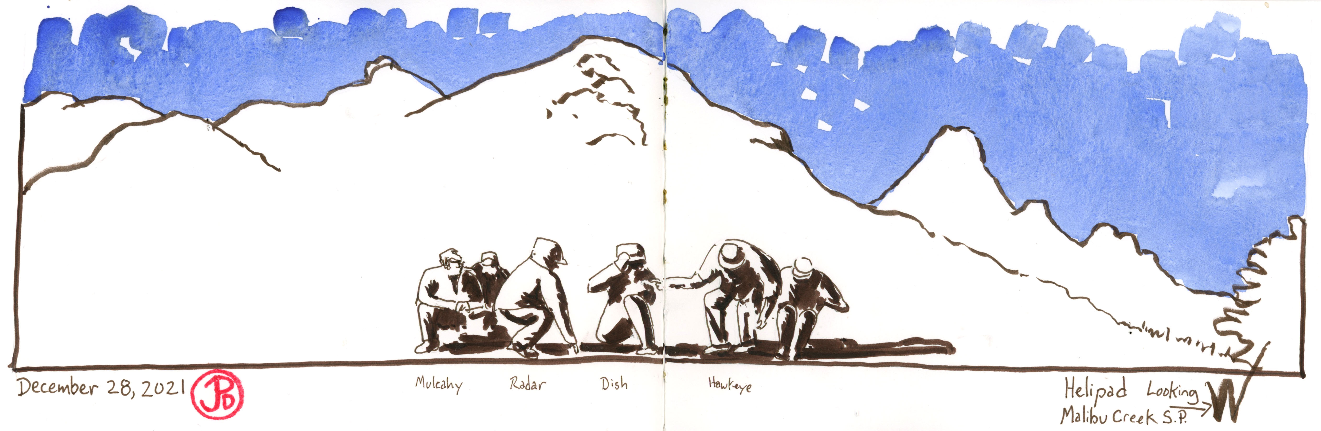
I climbed up the dirt road to the helipad that is featured in the opening credits of the show.

The very last shot in the opening is two jeeps headed slowly down the road, carried the wounded to the hospital tent and doctors madly attempting to help the wounded. The names of three actors appear: Loretta Swit, Larry Linville, and Gary Burghoff. The opening credits was one of the main reasons I headed to the helipad to sketch.

The road leading down from the helipad in the foreground and the Goat Buttes in the background.

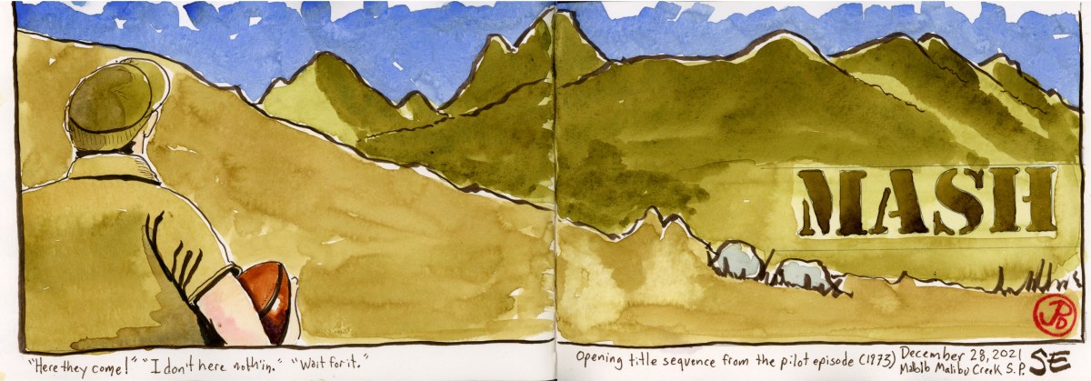
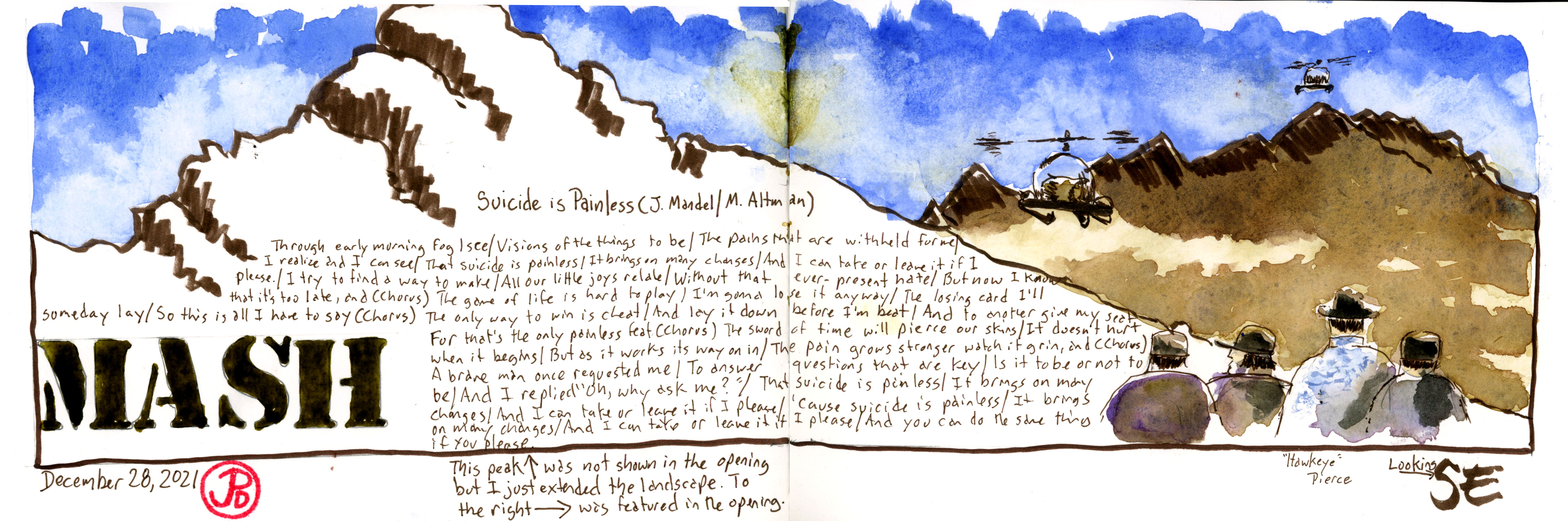
The iconic opening, as seen in the pilot episode, shows some downtime at the M*A*S*H unit: doctors golfing, doctors and nurses drinking champagne, reading, resting, and men playing catch. One solider catches the football, turning away in the process. He is about to turn back to the game of catch when he pauses and listens. He seems to know when something is about to happen before others do. “Here they come!” he announces. An off camera voice says, “I don’t hear noth’in.” And the solider, Radar O’ Reilly, quickly responses, “Wait for it.” We don’t have to wait long. The next shot is of Radar, from behind his right shoulder, as we look on with him, the camera zooms in to two helicopters flying over the mountains when the guitar refrain of “Suicide is Painless” starts off (in B minor).

M*A*S*H’s introduction is a part of my life’s television soundtrack like the opening of the Dukes of Hazzard, Dallas and Dynasty, The Facts of Life, The Electric Company (“HEY YOU GUYS !!!), Villa Alegre, and the Waltons. But somehow the M*A*S*H intro still holds up for it’s audio and visual impact, and I couldn’t wait to sketch the landscape of this groundbreaking series. In the 1970’s and early 80’s when you heard the first three notes of Suicide is Painless, it was time to rush into the living room to watch a new episode (or a repeat) of M*A*S*H.

I wanted to sketch this iconic opening, the choppers flying over the Santa Monica Mountains in the background and Radar in the foreground. To do this, I first sketched Radar (Gary Burghoff) to the left of my panoramic view. I did this a few weeks before heading out on the trail and it was based on a screen shot of the pilot episode opening. This preliminary sketch would be my anchor for the rest of the image. I just had to match the mountains in the background with the right angle. I knew that this scene had to be filmed from the helipad.

I searched all points on the compass and looking to the southeast, I saw the mountains that matched the opening exactly. I traded my pack and poles for my pens and journal and began sketching. The result is the featured sketch.

My aim was not to capture every detail in the landscape and I really just focused on the contours of the hills which have not changed much since they were first filmed for the opening almost 50 years ago. To outline their form I used my expressive brush pen which give vibrancy and economy to the line. This is where sketching holds it’s own over other visual media like photography. When I was tracing the curvaceous lines of the Santa Monica Mountains, I was really getting to know my subject in a deeper way. I was really seeing the landscape.

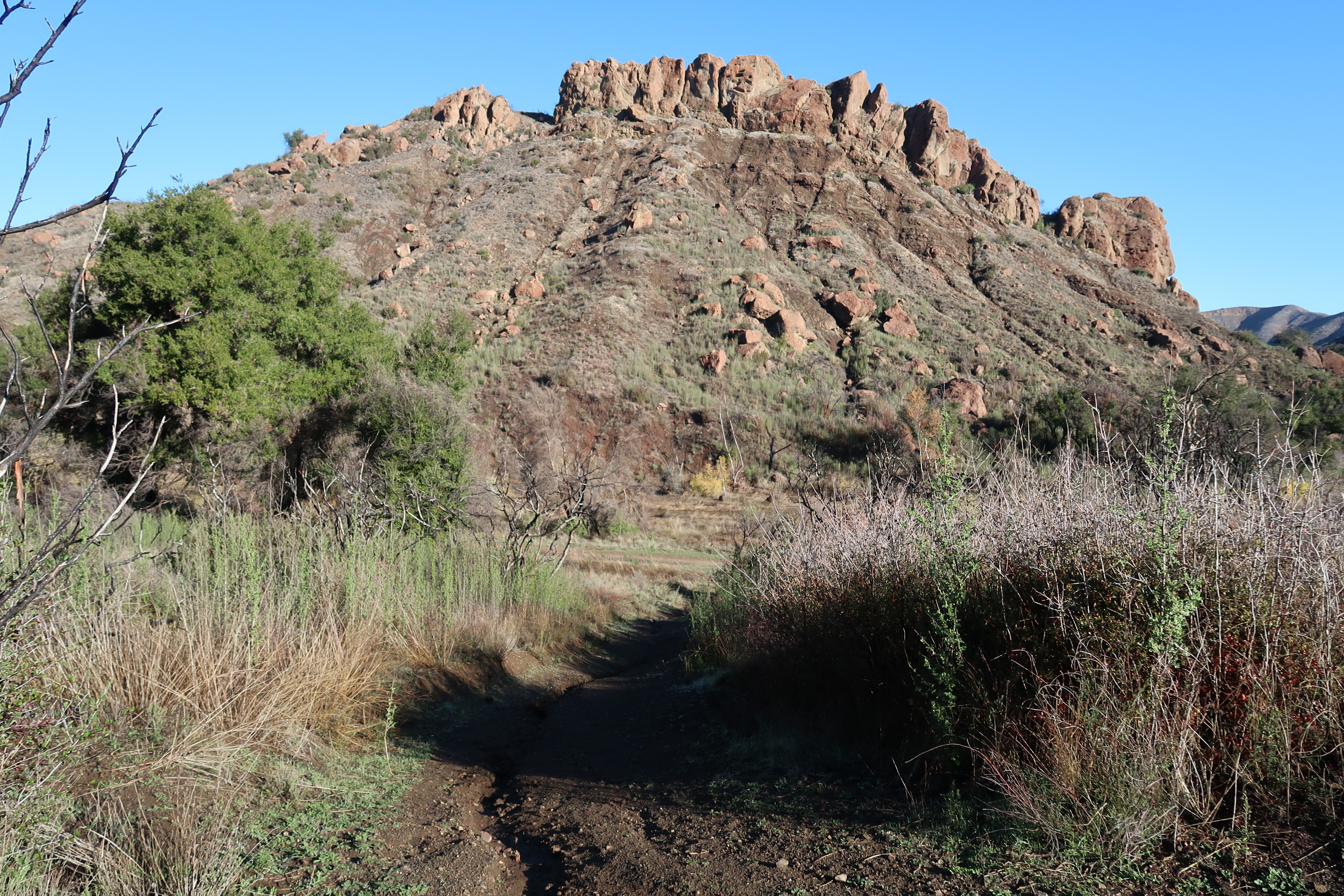
When I finished sketching this perspective, I then sketched two other perspectives from the opening credits. I then did a quick sketch of the road leading down to the main set featured at the very end of the opening credits. Let’s call it the “Loretta Swit, Larry Linville, and Gary Burghoff Road”.

This is another sketch from intro of M*A*S*H. The sketch to the right is what is seen briefly in the intro and what is on the left extends the landscape of the real location. I wrote in the lyrics of “Suicide is Painless” in the foreground hillside (This song was used in M*A*S*H the movie). Originally, director Robert Altman wanted the lyrics to sound like “the stupidest song ever written”. When the songwriter, Johnny Mandel could not come up with the right lyric, the director asked his 15 tear old son, Michael to write them, and this became one of the most memorable songs in cinematic and television history.
This is the last panoramic sketch I did from the helipad, this time looking west. In this scene from the opening in the foreground, Hawkeye Pierce gestures to others to head in as they move to the right, just after the chopper has landed with casualties. l lined up the background from a screen shot of the opening.

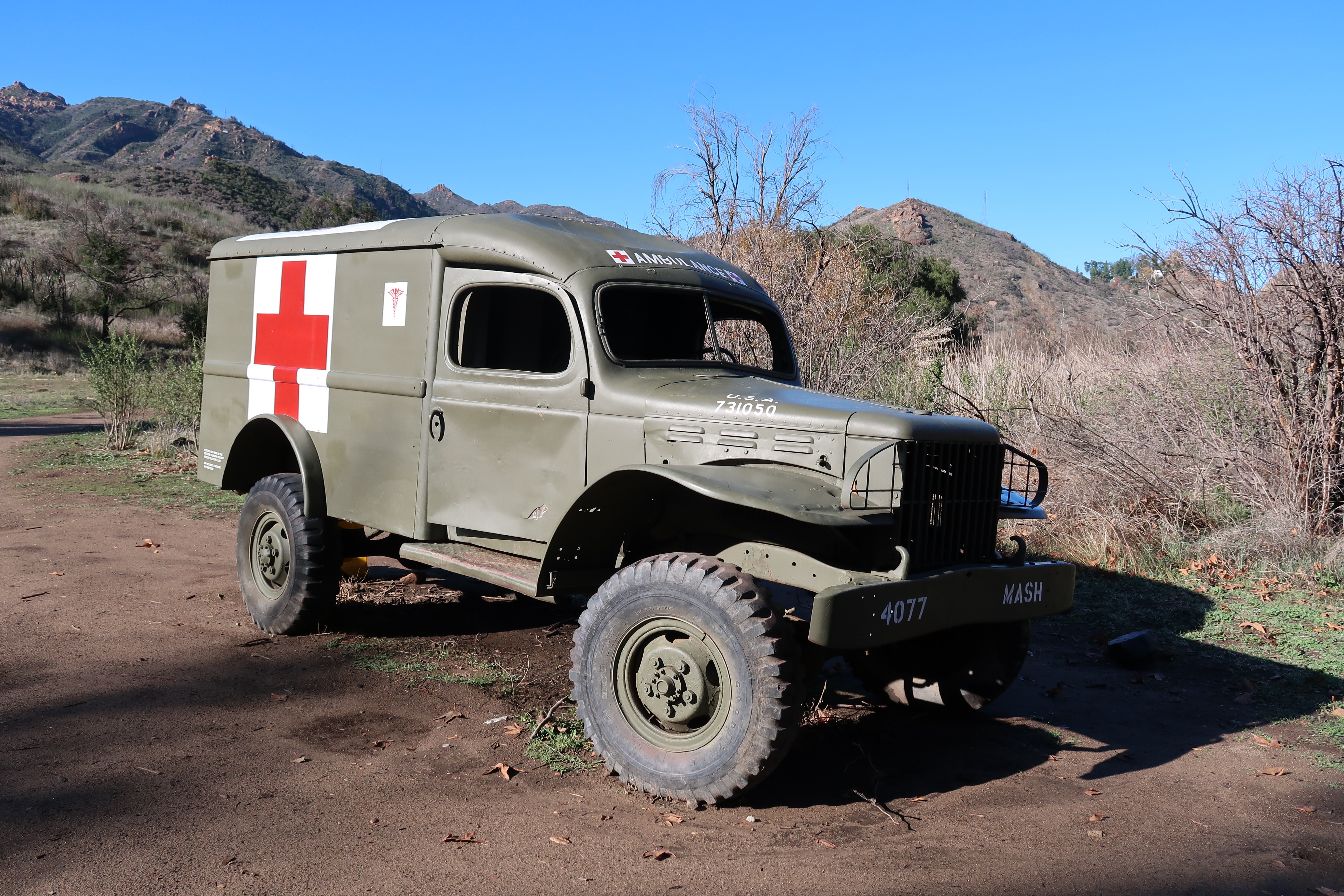
I then headed to the core of the set and I wanted to sketch the burnt out ambulance. This ambulance had been used in the original series but had been damaged during a brush fire during the final season of the show’s production in 1983. I took a seat at a picnic bench and started sketching away.

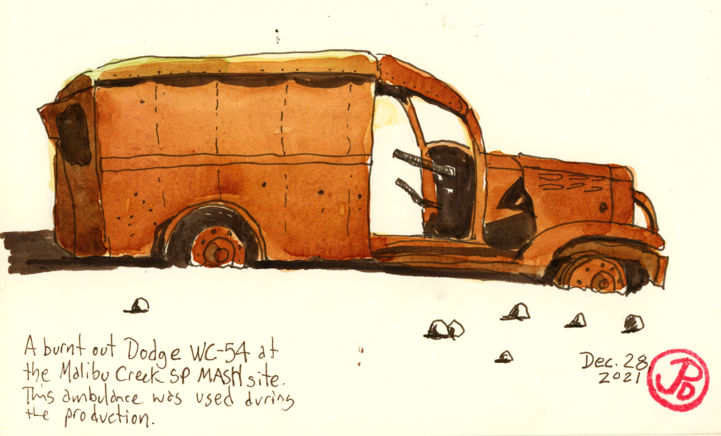
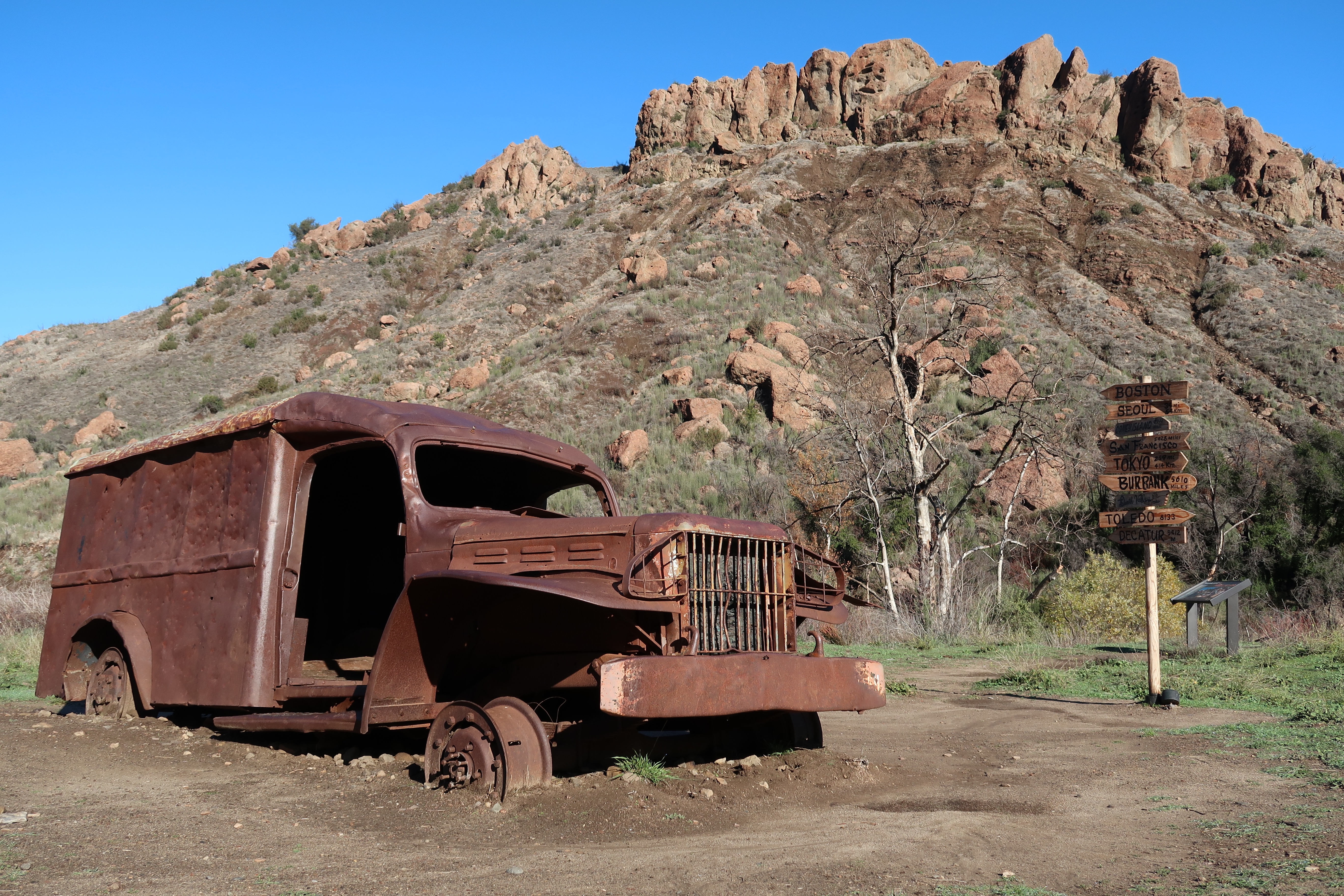
The contrast between the ambulance that had seen better days with the unchanged landscape of the Goat Butte was an essay in the unchangeable change in the world around us.

What a great morning of sketching at the M*A*S*H site. The skies where clear, having shaken off the showers of the pervious day and I had the entire site to myself!

Image

M*A*S*H, Malibu Creek State Park, Part 1

I headed out early from my Topanga Canyon digs on a 23 minutes drive to Malibu Creek State Park.

I would be hiking just over two miles (2.37 miles to be exact), on a fireroad called Crags Road, to the location set for the popular television series M*A*S*H (1972-1983). This state park was once the filming backlot for 20th Century Fox and many other tv shows and films where also filmed here, including the original Planet of the Apes. More on that film in a later post.

The level trail, which paralleled the rain-swollen Malibu Creek, was muddy from the rain over the past few days. Mist hung below the beautiful mountainous peaks of the Goat Buttes. The buttes are part of the Santa Monica Mountains, the only mountain range in California that runs west to east. I felt I was already in the “Korean” landscape of M*A*S*H. This landscape looked very familiar.

After I passed the side trail to Rock Pool, Crags Road began to climb upward in a muddy assent. The trail briefly leveled out and I headed down towards the former location of Ape City, built in the late 1960s for the sci-fi classic Planet of the Apes. But more about that in another post.

The fireroad now narrowed as it continued to parallel Malibu Creek. At this point I had not encountered a single person on my hike. I hoped that I would have the M*A*S*H site all to myself! The early bird, indeed gets the worm!

The beautiful long shadows of winter sun. On Crags Road less than 0.8 mile from the M*A*S*H site. But first I had to cross the creek.

I followed the sign to the creek crossing only to find a wooden staircase the led into the waters of Malibu Creek! The creek was impassable here, unless I was willing to swim. I looked upstream and I could just make out a makeshift “bridge” constructed of logs and tree limbs. Perhaps “constructed” is too much of word to describe the crossing but I had to chance it to get to the M*A*S*H site, which was on the opposite side of the creek.

I started across the “bridge”, carefully choosing each footfall on wobbly and far too thin sticks and logs. Here having trekking poles helped afford two more points of balance during the crossing. One pole slipped off a log and I attempted to put the pole down on the bottom of the creek, only to find that it was so deep that my pole was suspended in midwater. I made it to the opposite bank without becoming fully or partial immersion. I made sure my journals were safely stowed in a dry bag.

I now bushwacked to find the trail, which at this point did not resemble a fireroad but a single track trail. I was now very close, perhaps 0.5 of a mile and I was waiting, with childlike anticipation, for my first glimpse of the filming site. As I rounded a corner, I saw a Korean War era ambulance by the side of the trail. This marked the edge of the filming set.

This is a restored Dodge WC54 ambulance, which, despite what other have stated online, was not actually used during the filming of M*A*S*H. When you come up this vehicle, you know you about to enter the set.

I briefly scanned the site, which included three interruptive signs, two burnt out vehicles (a jeep and an ambulance) from the series, picnic benches, and a replica of the iconic signpost that was placed just outside of The Swamp. But before I explored the site properly, I headed up to the helipad to do some sketching. And yes, I had the site to myself, in beautiful clear winter weather!

This burnt out ambulance was used in the series. An ambulance similar to this is featured in the opening credits. A brush fire burnt the set during the final episode in 1983 and the fire was written into the script.
The replica signpost with the distinctive outline of the Goat Buttes.

The featured sketch is a map of the M*A*S*H site. I drew this before I head down to Malibu and it helped orient me when I was visiting the location for the first time.

Image

Suicide is Painless, It Brings on Many Changes

The hugely popular television series MASH, had it’s initial run from 1972 to 1983, spanning the first eleven years or so of my life.

The series became a backdrop or soundtrack to my life. While my family did not watch the show religiously, I knew the theme song (“Suicide is Painless”), the iconography, and characters of the show. Today, it seems like somewhere, around the world, one of the 256 episodes of MASH is being aired somewhere as a rerun.

The dramatic/comic series follows the doctors, nurses, soldiers, and patients of the MASH (Mobile Army Service Hospital) Unit number 4077 during the Korean War. Often in conflict are the civilian doctors (Hawkeye Pierce, Trapper John, and later B. J. Hunicutt) with the enlisted officers of the unit. The popular series ran for 11 years while the Korean War lasted for just three.

On my winter break, I planned to head to the southland to do some field sketching of one of the most iconic locations using during the MASH movie and the television series. This was the former 20th Century Fox backlot used from many films (Planet of the Apes) and television series (MASH) which is now Malibu Creek State Park.

Of course I started my planning with a map. In this case, a map of the Malibu Coast covering Topanga, Malibu, Zuma Beach. and Malibu Creek State Park.

I often like to do some sketches before I leave on a trip to put my mind’s eye into the location. The featured sketch is based on a screen shot of the pilot episode of MASH, the television series showing the iconic opening as Radar looks on as two helicopter fly towards the helipad with wounded soldiers. The second sketch is of the famous MASH signpost. This was based on a photo of a replica of the sign. The original signpost is in the Smithsonian in Washington DC. I used a little artist license as I changed two of the locations to reflect the real location of the set: Malibu and Topanga (where I would be staying).