Image

The Kennedy Mine

The popular image of a Forty-niner era goldminer is of a bearded man in a flop hat, a checkered shirt and suspenders, and jack boots. In tow was his “mountain canary” or burro and strapped to the burro was his spade and gold pan. He might have a piece of mining equipment call a rocker. Perhaps this was the image of a miner in 1849. But mining in the Gold Country continued up until World War II and at a much larger scale.

In the town of Jackson is a perfect example of a large scale mining operation that operated halfway into the 20th century. The towering headframe of the Kennedy Mine can be seen from Highway 49. I had seen this many times on my way to the Eastern Sierras but I was in Jackson on a Saturday when the Kennedy Mines were open to the public and this was the final Saturday of 2018 that the site would be opened. This would be the first time that I would be able be see this massive mining operation up close!

The Kennedy Mine is known to have the deepest mine shaft in the United States at the time of its closing. The shaft reached 5,912 feet down into the earth. The area was first mined in 1860 by Andrew Kennedy who later sold his share in the mine and the following year and the Kennedy Mining Company was formed. Many improvements and changes happen in the intervening years. The mine was closed in 1942 by the US government because of the war effort. After the war, gold mines could be reopened but the shafts and tunnels of Kennedy Mine were flooded with water so the company chose to keep the mine closed. At the time of its closing the miner had produces $28,000,000 worth of gold.

The center piece of the mine is 135 foot high East Shaft head frame which is the tallest headframe that is still in existence. It acts like a beacon that can be clearly seen from Highway 49 when heading down the hill to downtown Jackson.

Image

Chaw’ se

On the fourth day of my Highway 49 road trip I headed off the highway to night in the historic town of Volcano in the equally historic three story hotel the St. George. One of the reasons I headed off the highway was to visit Indian Grinding Rock State Park or Chaw-se as the native Miwok call it.

I had seen chaw’se or grinding rocks at Coloma before. These mortars which were grinded into stone were used by native peoples to grind acorns into a fine powder. Each depression took generations to create. Each hole could take over a century of work.

I was now looking over the largest concentrations of grinding rocks in North America. There are 1,185 mortar holes in this State Park.

I walked over to the ceremonial roundhouse, which is still in use by the native people of California. I sketched the structure along with the life-giving valley oak.

The roundhouse was the center of Miwok life and this roundhouse was constructed in 1974.

On my way out I sketched thew beautifully rusted stature of a Miwok dance by J. L. Plamondon which is: “Dedicated to the First People of California”.

Image

Calaveras Big Trees

No other Giant Sequoia grove illustrates the worst and the best of humanity as Calaveras Big Trees State Park.

I’ve visited other sequoia groves in the Sierras but this was my first visit to the epicenter of this iconic, Californian tree that captured the world’s attention.

The story goes that in 1853, Augustus T. Dowd was tracking a wounded grizzly bear that eventually led him to a massive tree that was over 1,000 years old, the likes of which had never been seen by white European settles before. Of course the native Miwok had known about the sequoias for centuries.

Dowd returned to his camp near Murphys and told all that would listen about his “discovery “. Few believed him so he offered to take a party of nonbelievers to the massive tree, to see for themselves.

The tree that Dowd showed to the party he brought with him is now known as the Discovery Tree. The following year demonstrates man at his worst when five men took 22 days to cut the tree down. No saw was large enough to cut through the massive truck so they drilled hundreds of holes through the tree with pump augers until it eventually fell. The evidence of the destruction is still visible today in the large section of the tree know as the Chip of the Old Block.

The holes drilled in 1854 to take down the Discovery Tree by an auger pump drill are plainly visible today. The Big Stump is visible on the right handed of the picture.

A two foot thick cross section of the giant trunk was cut and along with sections of bark, was sent to San Francisco to be displayed for profit. After being displayed for two months, what was now billed as “The Giant Tree” was packed up and shipped around Cape Horn to be displayed in New York City. The remains of the tree was eventually destroyed in a fire, in 1855. Prompting William Tweed to write in his book King Sequoia, “We can only wonder whether anyone noticed the irony that a tree that had endured for more that 2,000 years in the wild ended up as a commercial exhibit that lasted barely two years.”

This stump that remained in the grove was planned and used as a dance floor prompting John Muir to write, “The vandals then danced upon the stump!” The fallen length of the Discovery Tree was used as a double lane bowling alley and a bar.

Humans finally came to their senses and the grove eventually became protected as a State Park in 1931.

After sketching the Big Stump and Chip Off the Old Block, I continued on the North Grove Loop Trail which provided a great understanding of the natural history of these incredible giants. I stopped to sketch the Empire State Tree.

Further along the loop trail was one of the most striking examples of humans abusing and exploiting the giant sequoia for profit when I saw what remains of the Mother of the Forest tree. It is now a huge, scared and burned snag. In 1884, scaffolding was build around the tree and rose up to 116 feet. The tree was stripped of its bark and the bark was shipped to be reassembled and displayed in places like New York and London. John Muir remarked, “Skinning this tree alive is as sensible a scheme as skinning our great men would be to prove their greatness.” Without its protective bark the tree was severely burned in the fires of 1908. We can only hope that we learned that it is far better to protect these giants than it is to destroy them.

The good is humanity persevered this sequoia grove which still fills modern visitors with awe. Even though I have been to other sequoia groves in the Sierras, the North Grove at Calaveras Big Trees State Park, filled me with reverence for this incredible tree that captured the world’s attention.

Image

BoomTown to Ghost Town

The Gold Rush was a time of boom and bust. Many towns first started as miner’s camps composed of canvas tents centered around a mining area. Perhaps tents were replaced by more permeant structures made of wood. In most miner towns there inevitably was a fire which destroyed all or part of these mining towns. When the towns were rebuilt, the structures were built of brick and it is these structures that are around today, either as a still functioning structures or as a Gold Rush ruin.

Many of the towns that I drove through on Highway 49, tell of this boom and bust. Some towns would have populations of 3,000 or 5,000 people at their height and then the diggings would be mined out and the town’s population would disappear to the next new gold discovery site. No two towns exemplify this today more than the prosperous town of Columbia and the virtual ghost town of Hornitos.

Gold was discovered in the area around Columbia on March 27, 1850. Columbia became a boomtown with its population swelling to 5,000 with 150 saloons to quench the thirst of parched miners. Over that time $150 million worth of gold was mined from the hills surrounding the town becoming one of the most prosperous areas in California’s Gold Country. At one time, Columbia was the second largest city in California and was once considered for the site of the state capital.

The centerpiece of Columbia State Historic Park, the 1858 Wells Fargo & Company building. More than 1.4 million ounces of gold was weighted out in this building.

By the 1860’s, most of the gold had been mined out and the population decreased. But Columbia never became a ghost town. The two story brick schoolhouse (built in 1860), which was used up until 1937, speaks to the vibrancy of the town that never gave up the ghost.

In 1945 the state bought the land and preserved the site of the historic downtown as Columbia State Historic Park. It now represents the largest collection of Gold Rush era buildings in existence. Walking down Main Street is to take a step back in time.

During the Gold Rush, Hornitos was known as one of the roughest and toughest towns among the southern mines. The outlaw Juaquin Murrietta is reputed to have used Hornitos as a hideout. The town predates California’s Gold Rush and was founded by Mexicans who were kicked out of nearby Quartzburg. During its height it is said that Hornitos had a population of 15,000 and was the only incorporated town in Mariposa County.

Now Hornitos is a backwater, 13 miles from Highway 49 in what seems like the middle of nowhere. The town, well really settlement might be a better name for it, now has a population of about 60 souls. But as I walked the street of “downtown” Hornitos, the only sign of life were the cows in the far fields and 80’s pop music blaring from a house that looked it had been abandoned back it the late 80’s. At least they have electricity in Hornitos.

I was standing in front of the building that had drawn me away from Highway 49 to this small town. The red brick building is now just a hollow shell of its former self, a ruins of a former business started by an Italian immigrant. His name was Domenico Ghirardelli and it was in this brick building that his chocolate empire began. Here in Hornitos, Ghirardelli ran a general goods store from 1855-1858 and he sold the store and headed to San Francisco to start his chocolate business.

This ruins is a reminder that the people who made money during the Gold Rush were not always mining for gold, they were mining the miners.

Image

Twain in the Gold Country

When Mark Twain’s name is mentioned, steaming paddle boats on the Mississippi River comes to mind. He is, after all, the author of what has been called the “Great American Novel”, The Adventures of Huckleberry Finn. The setting is firmly placed in the Antebellum South. So why is it that on Highway 49, near Tuttletown, there is a historical marker (No. 138) with Mark Twain’s name on it?

It was in California’s Gold County that the 30-year-old journalist, Samuel Clemens (aka Mark Twain) spent the winter of 1864-65 in a cabin up on Jackass Hill. The cabin belonged to the Gillis Brothers, who where local miners. Maybe this fact alone would be worth a historic marker on 49 but it is what he did when he went into town and visited the saloon in the Angels Hotel in Angels Camp, ten miles north of Jackass Hill. What he did was presumably, have a drink and listened to a tall tale.

That tall tale became the short story, “The Celebrated Jumping Frog of Calaveras County”, which was first published in the New York Saturday Press on November 18, 1865. This is the short story that is credited with setting Twain on the road to literary fame. It was in the rainy winter that he discovery his fortune as Twain noted, “right in the depths of [the miners’] poverty and pocket mining lay the germ of my coming good fortune.” He saw his 88 days in the Gold Country as the turning point of his life.

And so it was that I turned off Highway 49 and headed up a narrow road to the top of Jackass Hill. At the top was the Gillis Cabin. The building itself was surrounded by a fence, as if it was an animal at a zoo. The cabin itself is a replica of the original. The original succumbed to the plight of many wooden structures of the day: engulfed in flames. The chimney, however, is original to the time when Twain stayed here.

I set up my folding camp chair and sketched the cabin sans fence. I felt like I was sketching at the zoo. Except my subject stood stock still.

After sketching, I heading back down Jackass Hill and continued north on 49 to the town of Angels Camp. In town I sketched the frog historical marker which is across Highway 49 from the site where Twain first heard the yarn about the leaping frog of Calaveras County and also put Angels Camp on the map. All on account about a tall tale about a frog.

They really celebrate Twain’s short time in the area with Calaveras County Fair and Jumping Frog Jubilee which is held in May. The frog jump contest just celebrated it’s 90th anniversary last May (2018). This event is held in Angels Camp and is billed as one of the oldest such events in California. It is billed as one of the oldest Faires in California.

Image

Miner’s Justice

One of the first sketches I did on my Highway 49 road trip was of the Mariposa County Courthouse. This stunning courthouse is the oldest seat of justice in California. The courthouse was completed in 1854 and has been in use ever since. In fact when I visited the courthouse on Tuesday, I went up to the courtroom chambers above the entrance and they were conducting jury selection for an upcoming trial. I was relieved at this time that I was not a resident of Mariposa County!

Many famous legal battles regarding miner’s rights and claims were fought in this very courtroom and here it was, still in use!

IMG_4623

Solving disagreements in a court of law was a new thing in the wild west of the Gold Rush days. It was was more common in miner’s camps for disputes and crimes to be solved by miner’s “rough” justice. And sometimes on the branch of a oak tree in Hangtown, which now bears the name Placerville. The Hanging Tree is now long gone but further north on 49, 30 monies from Nevada City, I saw Downieville’s version of their hanging tree.

Downieville has the dubious distinction of lynching the only woman in the State of California and it is in Downievillie that it is the only place in California that they have their gallows on display.

Gallows

The gallows was last used on November 27, 1885 when 20 year old James O’Neill was hung to death for the August 7, 1884 murder of his employer John Woodward. This execution was the last legal execution in Sierra County and it was they only time the gallows was used. At the time the gallows was constructed it was only set up temporarily for it’s sole purpose and then it was disassembled and placed in the courthouse attic for storage. In 1891, local executions ended, being moved to San Quentin and Folsom prisons and in 1941 the state banned hanging as a means of execution in favor of San Quentin’s gas chamber. Isn’t history great?!

Image

Highway 49 Road Trip

California Highway 49 runs north and south, winding 310 miles through California’s Gold County. It passes through eleven counties and 51 cities, towns, and settlements. It is perhaps California’s most historic highway and I was going to drive all 310 miles of it, starting at it’s southern terminus at Oakhurst to where the highway ends at it’s northern terminus at the junction with Highway 70 at Vinton.

My guild throughout my road trip was the green, spade-shaped shields that read: CALIFORNIA 49. NORTH. The shape of the sign is a reference to the spades used by Forty-Niners to dig for gold when the world rushed in during California’s Gold Rush in 1849. The state highway agency adopted this symbol of the Gold Rush in 1934 and has been used ever since on all of California’s state highway signs.

The first Highway 49 shield at the start of the highway in Oakhurst on my first day of my road trip.

I could drive the entire highway in one very long day but I chose to break the road trip up into a five day trip, giving me time to explore the towns, back roads, and historical points of interests along the way. And of of course encountering the landscape and townscapes in the same way that many immigrants did in the 19th century, in the pages of a sketchbook.

The northern end of 49 at the junction of Highway 70 in the beautiful Sierra Valley.

In the next blog posts, I will features sketches in the many places I visited on my road trip on historic Highway 49.

The northern section of Highway 49 is the most scenic as it runs through Sierra Valley at 5,000 feet.

Image

Me and a Dipper

I came down to the valley to sketch the monolith El Capitain but instead I stopped at the banks of the Merced River, Bridelveil Falls falling silencing across the valley and I sketched a dipper.

It says a lot about the American dipper that John Muir devoted an entire chapter of The Mountains of California to this small, drab bird. The water-ouzel, as the dipper was known then, rewards the observer with the amount of time put in by simply sitting down on the river bank and watching.

The dipper is seldom still, making sketching a challenging yet exhilarating experience. Just when you start one sketch you stop and restart because the dipper has disappeared under the river, appearing again, perched on a submerged rock, making the bird appear to be standing on water. And the dipper never just perches. Like it’s name implies, it it constantly dipping it’s body up and down.

As so I passed part of my morning in Yosemite Valley, with my back facing the largest chunk of granite in the world but my eyes focused on one of the most captivating creatures to be found in any National Park: the American dipper.

And as Muir wrote about the dipper, “Among all the mountain birds, none has cheered me so much in my lonely wanderings, -none so unfailingly.” And I couldn’t agree with John Muir more.


Image

Obata’s Yosemite

I left the Wawona Hotel before light, my destination was Glacier Point and I hoped to have the place to myself (if that is ever possible in this very popular National Park).

The view from Glacier Point is probably the best view in Yosemite, if not the entire National Park System. Right in front of you, Half Dome rises up and leaning over the rail, you look down into this famous glacier-sculpted valley.

IMG_4670

It was a beautifuly crisp fall morning above the valley and as I sketched Half Dome, I had the point to myself for a whole six minutes! An eternity in Yosemite, these where geological minutes.

IMG_9721

I’ve got the place to myself, well at least for another two minutes!

I chose to use a loose, brush technique, inspired by the paintings and woodcut prints of Chiura Obata (1885-1975). Obata’s images of Yosemite and the Sierra Nevada Mountains, are as iconic to me as a Bierstadt or Hill painting or an Ansel Adams photograph. I love this Japanese ascetic that he brings to a very familiar subject.

Obata immigrated from Japan to the United States in 1903. Obama became a well know teacher and artist in the Bay Area and every since visiting Yosemite for the first time in 1927, this National Park has become a major subject matter in his artist output.

Obata Half Dome

I tried to resist the urge to head to the valley floor which is usually crowded with people, even in October. One of the other most iconic views of Yosemite Valley is the one you get at Tunnel View. While all the tourists took selfies and photos, I sat on a stone wall and sketched this famous view, trying to summon my inner Obata.

Obata Tunnel View

Image

Summer Camp

They say you can never go back to summer camp as an adult but I was sure going to try.

Like most childhood memories, the setting is often divorced from the memory itself. I find this out almost every Monday when I learn that one of my students has gone camping over the weekend. My first question is, “Oh, where did you go camping?” The inevitable answer is, “Ahhh. . . I don’t know.”

I retained certain details from my summer camp experience, which was 30 years ago, like the name of the camp: Skylake, and the lake it was near: Bass and aided by photographs in a album, I have images of people, my councilor Bil, and locations: my cabin and the horse coral and actives: horseback riding, archery, waterskiing, and canoeing, but other than that I had no idea where my summer camp was, other than I knew it was somewhere near Yosemite.

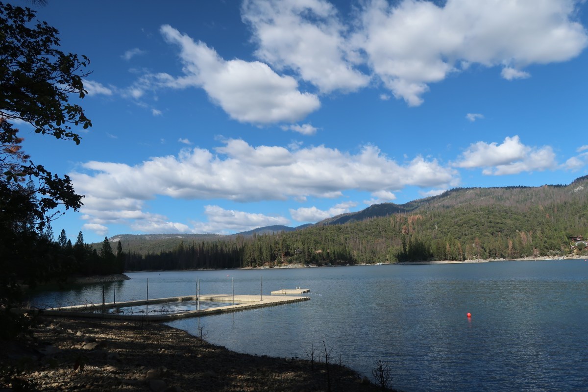
A casual glance at a map reals many lake named “Bass’ in the United States. I looked at a Yosemite regional map and found a Bass Lake just south of the Wawona entrance to the park. A web search revealed that Skylake Yosemite Camp was indeed still in business but under a new ownership. Well I couldn’t go to Wawona without first going back to camp!

All was well when I turned right off pf Highway 41 at the Bass Lake sign. Well this was going to be easy, I thought, one road to the north of the lake and one to the south. What I didn’t take into consideration was that I could not see the lake through the woods. And when I finally did see the lake, it was to my right and I wanted it to my left which meant I was on the north shore and not the south where Skylake was located. Oh bother! As pooh would say.

I figured I would just keep driving east until the road curved around to the south side of Bass Lake but the road kept going east and not south, like I wanted it to. I eventually consigned myself to defeat, turned around and headed back along the north shore on the roadway of shame. I turned left and made a false foray into a housing development, turned back, and stopped at the ranger station and got a map (something I should have done about 45 minutes ago). I finally found the correct road, memorably named Road 222 and headed east along the south shore.

I looked at Bass Lake, trying to connect my memories to the location. The only thing I could come up with was there seemed to be more large house on the north shore than I seemed to remember. Well the last time I was on this road heading in this directions was 30 years ago, aboard a bus loaded with excited campers.

I did remember that there was a picnic area on the shore near the camp and Pine Point Picnic area appeared on my left, I knew I was very close! I rounded a curve and there was the sign on the right side of the road, “Skylake Yosemite Camp”!

I turned up the single track paved road, the ideal scenario running through my mental cinema: I would pull into camp and the off-season caretaker named Gordon (and not Jack) would look up from raking the leaves from the parking lot near the flag pole and welcome me to Skylake. He would commence a grand tour of the camp and memories would come flooding back. Instead I was greeted by a fallen oak, blocking the entire roadway.

I returned to the camp dock remembering a canoe camping trip from 30 yeas ago. I remember setting of in the late afternoon to the northern shore and I remember sleeping under the stars.

IMG_4646

As I drove back towards Highway 41, one final memory came back. It was they day my dad came to pick me up to take me back home. He was the one who took the photographs. I remember it was great to see him and I gave him a our of the camp along with my best friend Erik. I think we must have driven around the lake, no doubt my father stopping along the shore to take photos. Now much has changed.

They say you can never return to summer camp but I tried.