Tomales Point Tule Elk Reserve

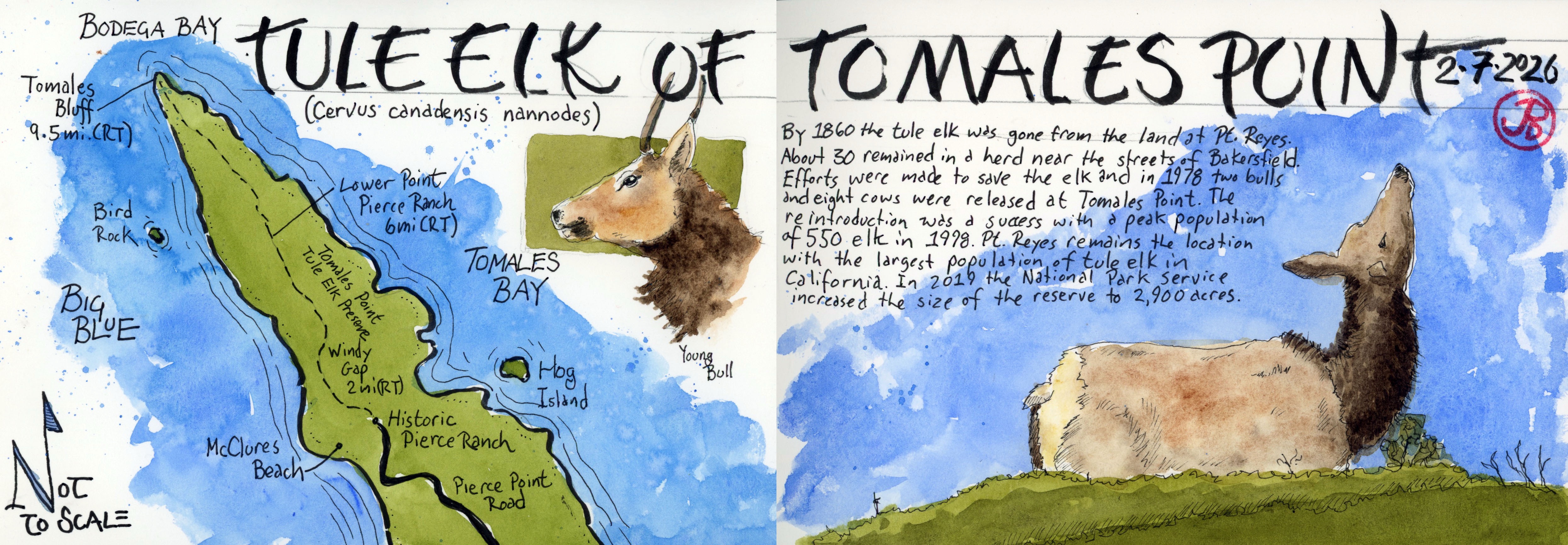
I headed to the most northern point of Point Reyes to see some tule elk.

I arrived at the dirt parking lot at the historic Pierce Ranch at 8 AM on Saturday morning. So early in fact, that the local California quail were out feeding in front of the old dairy buildings yet to be disturbed by the hiking groups and picnickers that would soon be arriving over the next few hours.

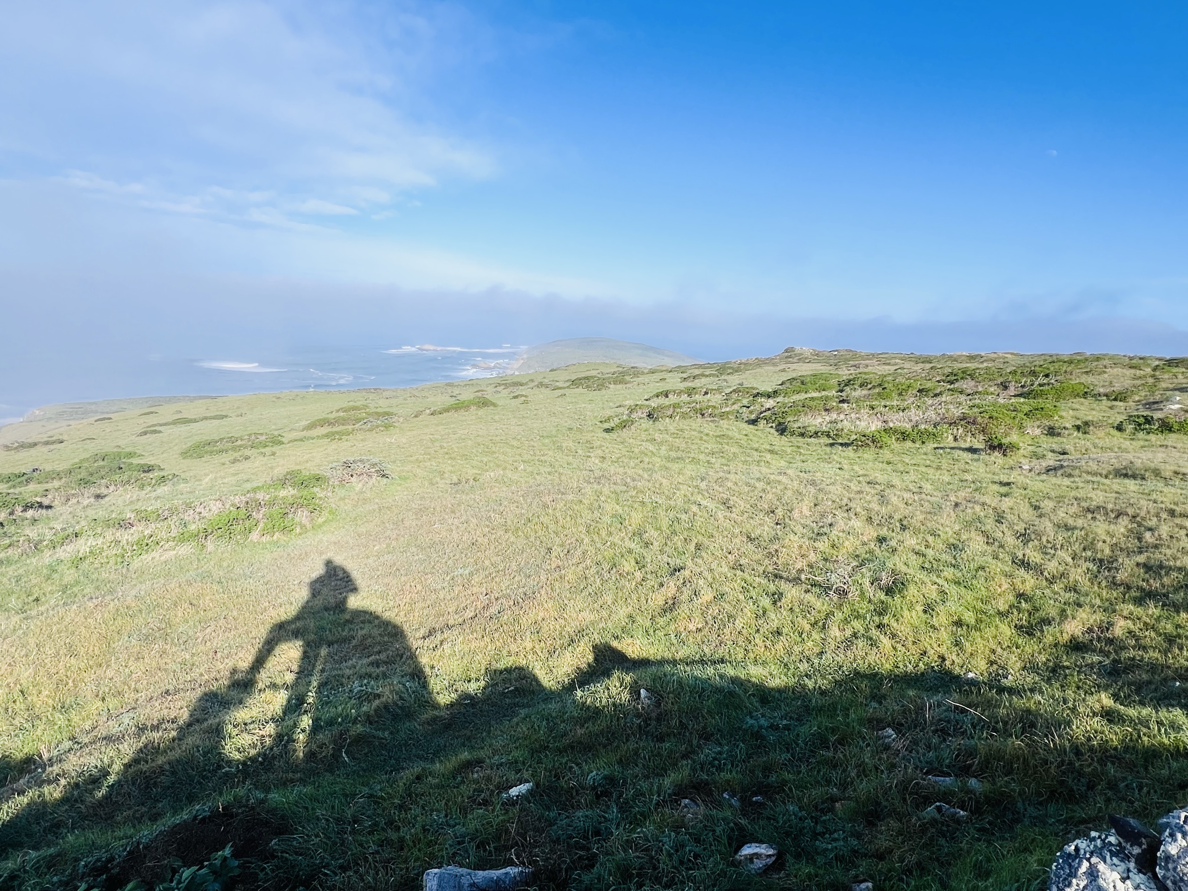
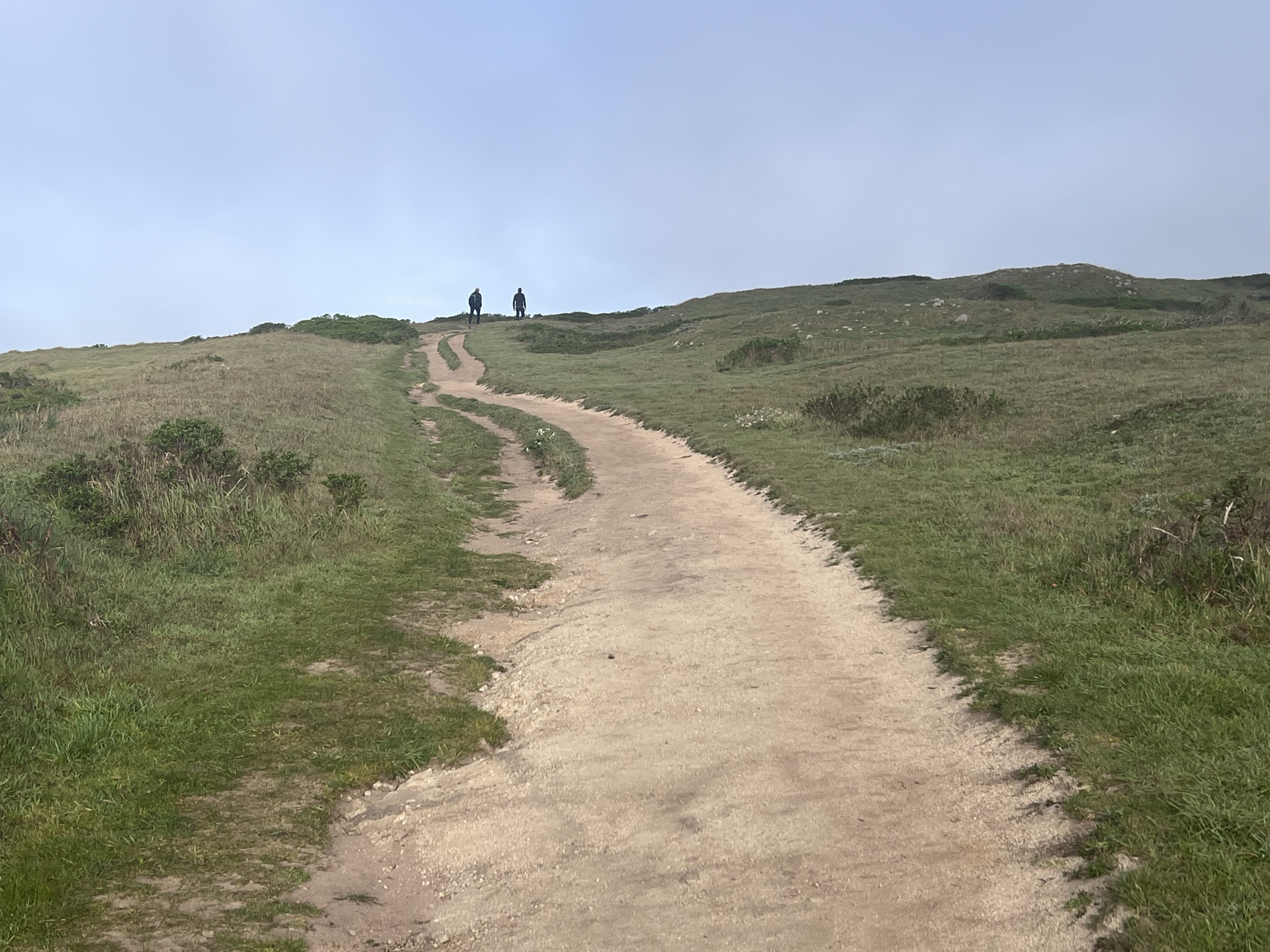
I hit the trail trying to put some distance between myself and the chatty group of six young folk looking extremely underdressed for a winter coastal hike.

Looking north on the Tomales Point Trail.

I was only on the Tomales Point Trail for a few minutes and I looked back towards the ranch and on the far hillside where a mass of golden brown dots. Tule elk! They were a long way aways but I hoped to get closer looks.

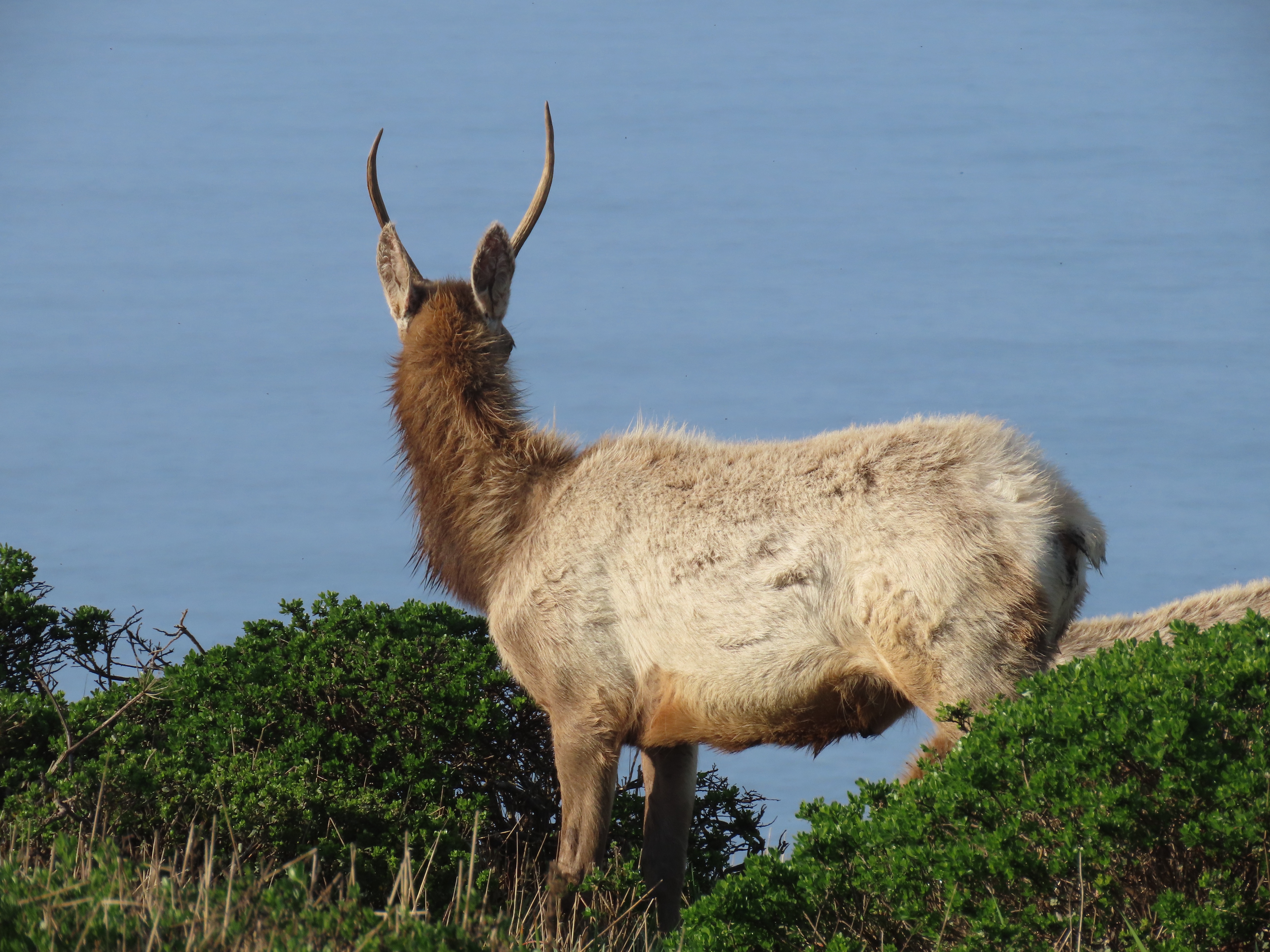
Tule elk (Cervus canadensis nannodes) were once native to this part of California but by 1860 they had disappeared from the land from over hunting and being displaced by cattle. This is the smallest subspecies of elk and are exclusively found in the Golden State.

The elk was thought to be extinct until a small group was discovered on a ranch near Bakersfield. Efforts were made to save the large deer with successful results.

Over one hundred years later in 1978, two bulls and eight cows were released at Tomales Point. The reintroduction of elk to Point Reyes was a success and the population peaked at 550 elk in 1998. The Pt. Reyes herd is the largest population of tule elk in California. One of the best places to see them is the Tomales Point Tule Elk Reserve.

After about an hour on the trail I approached the appropriately named Windy Gap, a great location for spotting elk. Up on the far ridge I could see the antlers of adult males breaking above the grasses and scrubs. They were a ways off but I hoped for closer views as I proceeded north.

These elk were close to the trail!

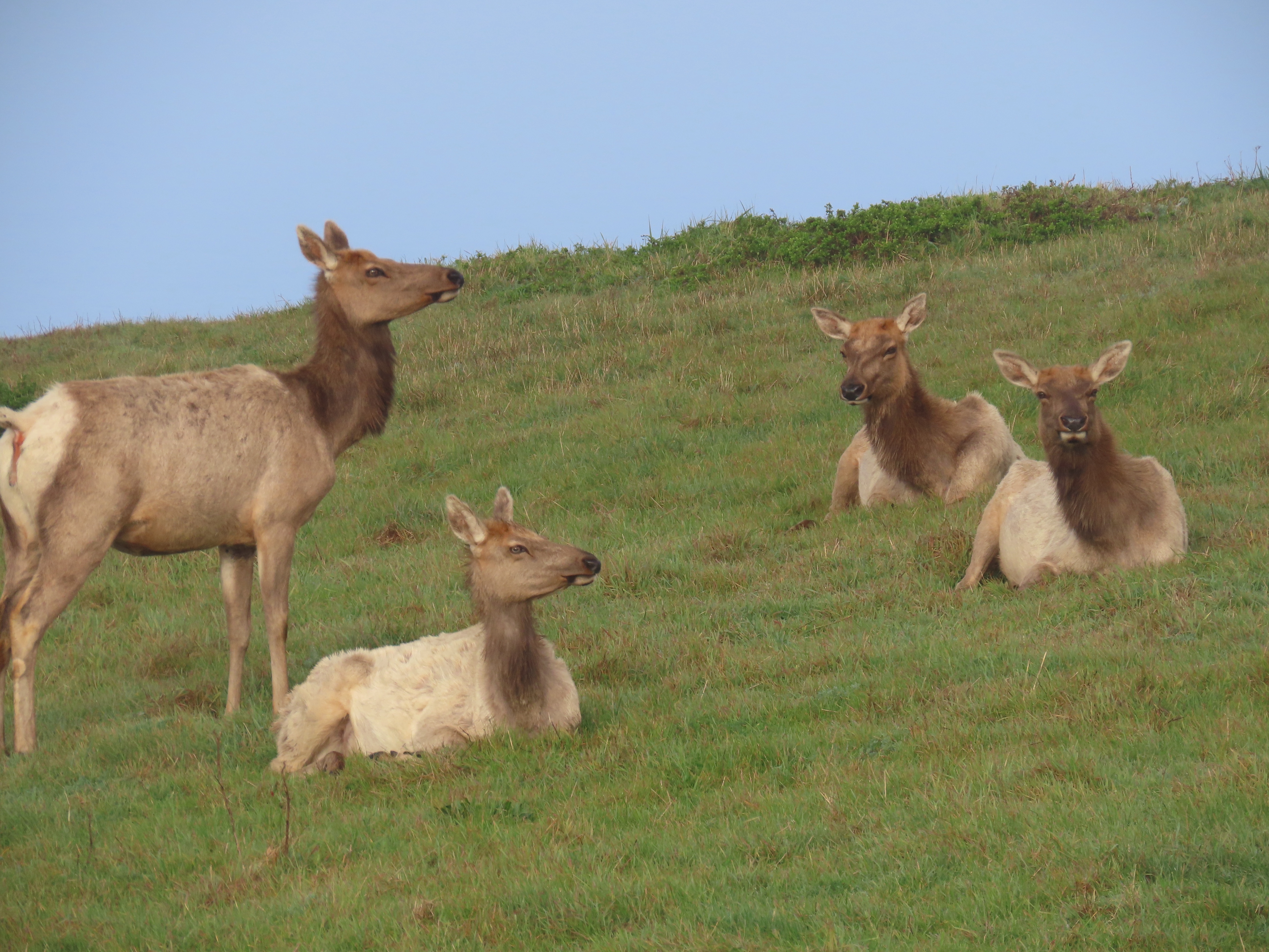
After heading up the other side of the gap I came upon a group of twelve cows and calves on the Pacific side. They sized me up with their deep dark eyes and their large ears. Was I harmless or a threat?

While I was not a threat, the chatty-scantily clad youths that were coming up behind me were. The elk stood up and moseyed north. But not before the girl in pink short-shorts and top took a few selfies.

Young bulls and the Pacific.

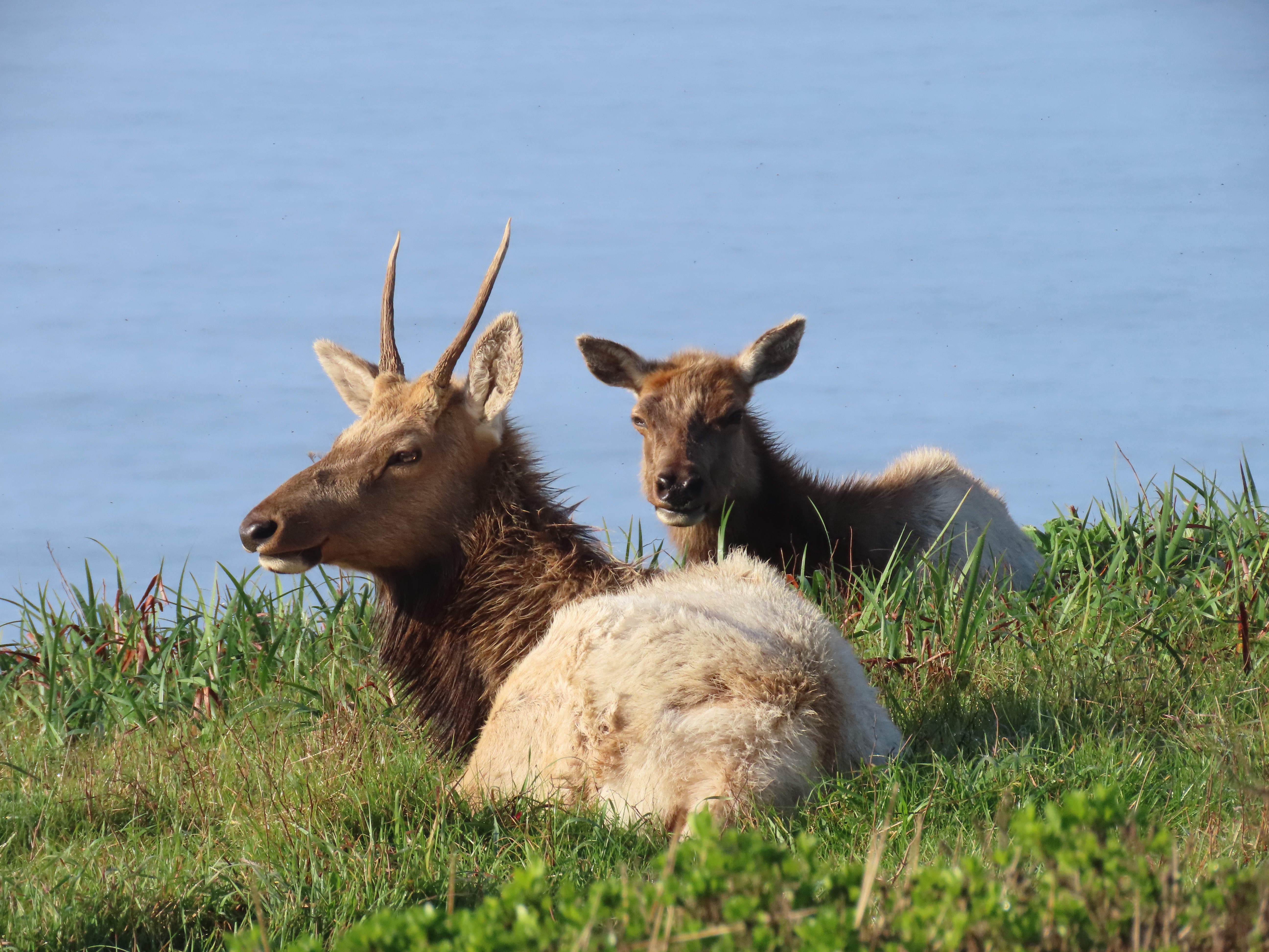
I headed another 15 minutes north and I came upon a group of young bulls that were resting (elks seem to do a lot of resting) near the trail. At this point in the year the males and females seemed to be in separate groups, until rutting season in the late summer and early fall.

Even though the young bull’s eyes are not on me, his ears clearly are.
Silhouetted against Tomales Point, looking north. This part of Pt. Reyes is stunningly beautiful.

Olompali

In honor of the recent passing of Bob Weir, I decided to sketch an early bit of Grateful Dead history.

This history is not to be found in the Haight-Ashbury but in the county where the members of the Dead spent much of the time when not touring incessantly: Marin County. Most of band lived in Marin, Bobby in Mill Valley, Mickey in Novato, and Jerry Garcia died at a rehab center in Forest Knolls.

The Dead house at 710 Ashbury. Home to the band in 1966 to 1968.

Just north of the town of Novato is Olompali State Historic Park. They are many layers of California history at Olompali: Miwok, Mexican, the Bear Flag Republic, Californios, and the estate of a wealthy San Franciscan dentist.

In 1911, James Burdell, built a 26-room mansion for the then hefty sum of $15,000.

The land and the house on it was eventually sold to the University of San Francisco. In the 1960s the university attempted to sell the property but the buyers always defaulted, leaving Olompoli unsold.

The properties’s most famous tenet was the band the Grateful Dead. The band moved here for a two month stay (May and June) in 1966 to take a vacation away from the Haight-Ashbury.

Stairway to . . . The buildings at Olompali have seen better days.

Their two month stay was a “happening”, a nonstop party that included the likes of Jefferson Airplane, Quicksilver Messenger Service, Moby Grape, Janis Joplin, David Crosby, Santana, the Merry Pranksters, Ken Kesey, Neil Cassady, and Timothy Leary.

Jerry Garcia referred to his time at Olompali as “idyllic”. It was also the setting for his last acid trip (it was a bad one). He returned here over the next three years.

Sketching the remains of the Burdell Mansion. Bands would set up in front of the mansion to jam as people danced on the lawn or cooled down in the swimming pool. The pool was off to the right.

After the Dead left, Don McCoy, a wealthy businessman, turned to the hippie life and started a commune, called the Chosen Family at Olompali in 1967.

Field sketch of the mansion, which is boarded up.

26 people moved to the mansion where they home schooled their kids and baked bread for charity, amongst other things.

Things soured after about a year with the influx of new members and more drugs and alcohol. Two children drowned in the mansion’s swimming pool. Much of the mansion burned down in a fire in 1969 and the commune was soon evicted.

The land was purchased by the state of California in 1977 and it became Olompali State Historic Park.

Image

The Railroad of Las Gallinas

Rails are notoriously cagey birds. To see one well, takes lots of patience and a good deal of luck.

When I first started birding the Holy Grail bird was the clapper rail (now called Ridgeway’s rail).

The best place to see them in the Bay Area was historically Palo Alto Baylands. And it helped to be there at high tide, preferably a King tide.

You wait on the boardwalk and look down a channel through the march, a railroad, and get a fleeting glimpse of a rail swimming across.

The idea was that the high waters would flush the rails up making them easier to spot.

I had fleeting views, at low tide.

There are other places of the unbroken marshes that once ringed the San Francisco Bay. That’s why the Ridgeway’s is a gem to see because it is uncommon and elusive and threatened. The rail is on the Red Watch list meaning it is a species of the highest conservation concern. So seeing one is always special.

One of my favorite birding areas Las Gallinas Valley Sanitary District, also happens to be a great place to encounter a Ridgeway’s. You may not always get a good view but you can usually heard them.

A railroad line at Las Gallinas.

You do have to walk as far east as you can to the marches buffer the bay and Miller Creek adds its water to the bay. To the left is a channel, a railroad, where I have seen rails before.

I walked out to the point, at a very high tide, and sketched the view (featured sketch).

A great view of a Ridgeway’s rail in beautiful light at Bayfront Park. These sights are not too frequent.
Image

The Fog

Ever since my babysitter let me stay up and watch Halloween on television (mom sure knew how to pick a babysitter), I have loved the films of John Carpenter.

One of Carpenter’s lesser known films was filmed on location in the Northern Bay Area. This is The Fog (1980).

This paranormal ghost thriller was filmed in Marin and Sonoma Counties, north of San Francisco. I wanted to revisit some these beautiful locations and do some Saturday morning sketching so I headed north over the Golden Gate Bridge.

The fictional town of Antonio Bay were really the west Marin towns of Stinson Beach, Olema, Pt. Reyes Station, and Inverness.

My first stop was Stinson Beach, or more accurately just southeast of Stinson Beach on Highway One.

About 50 minutes from leaving my Sunset digs, I was sitting in my sketching chair sketching the town of Stinson Beach.

The scene before me that I was adding to my panoramic sketchbook was the same view used for the title sequence for The Fog.

After finishing my sketch (featured sketch), I drove north on Highway One through Stinson and then skirted the shoreline of Bolinas Lagoon on my way to Olema.

Scenes were filmed in this area at the junction of Highway One and Sir Francis Drake Boulevard. The location featured two generations of scream queens who happen to be mother and daughter: Janet Leigh (Psycho) and Jamie Lee Curtis (Halloween). Neither did much screaming in The Fog.

Olema parking lot. The parking lot and the bar in the blue building to the right were used as filming locations in The Fog.

I continued on to Pt. Reyes Station where the “downtown” of Antonio Bay was filmed. The Fog demonstrates the patchwork nature of how location filming is used to create one whole location is is not usually geographically accurate.

Downtown Pt. Reyes Station.
Image

The de Young Museum

There is one art museum and one art exhibition from my youth that is at the fore of my memory.

I was in third grade when I visited San Francisco’s de Young Museum and the King Tutankhamen exhibit.

In 1979, the King Tut exhibit was a huge deal in the Bay Area. It seemed everyone had King Tut fever and wanted to see the treasures of his exhumed tomb.

The exhibit featured 55 objects including Tut’s golden death mask and sarcophagus. I have memories of marveling at the superb death mask.

The museum was founded in 1895. It moved to its present site in Golden Gate Park in 1919.

The building was damaged in the 1989 Loma Prieta Earthquake and was demolished. The museum was rebuilt in its current form in 2005.

Looking west from the tower with the galleries of the de Young.

I admit that I wasn’t a fan of the new building. But the view from the top is amazing. The building is slowly growing on me.

On a recent visit I did a western facing sketch from the top of the de Young tower of the Golden Gate and the Marin Headlands (below).

Image

Kirby Cove

On a November Saturday morning I decided to pop over the Golden Gate to one of my favorite places in the Bay Area: the Marin Headlands.

I spent 14 seasons as a hawk bander for the Golden Gate Raptor Observatory (GGRO) and I have spent many days in beautiful and sometimes foggy fall weather.

One call from other blinds would be, “RT heading towards Kirby Cove!” The RT is question stood for red-tailed hawk and Kirby Cove was my Saturday hiking/ sketching destination.

The distance from the parking lot on Conzelman Road to Kirby Cove Beach, as the hawk flies, is about a mile but the road from the trailhead takes a winding path downslope, to the beach.

The trail to the beach is a graded fire road that winds down to the Kirby Cove Campground. This proved to be easy hiking.

Who doesn’t love a bit of Radiolarian Chert in the morning?

From the trailhead to the beach took about 20 minutes. Before heading to the beach I looked for the Kirby Cove swing which had been taken down. I originally planned to sketch the view with the swing in the foreground. Well it was time for sketching Plan B.

I then headed to the beach and found a sketching seat on a piece of driftwood (a former power pole) and began sketching the view of the Golden Gate, the famous bridge, and the San Francisco skyline in the background.

Beachmaster!

Even thought the nearby campground was full, I had the beach entirely to myself during the duration of my visit.

A Princess cruise ship coming into the Golden Gate like so many gold seekers in 1849.
Image

China Camp Sketching

I took a weekday off and enjoyed a Wednesday morning sketch at China Camp State Park in eastern Marin County.

I headed to the old shrimp fishing village and walked down the pier to look for a good sketching perspective.

China Camp from the end of the pier.

It looked like the beach to the southeast looked best. I walked down the beach and found a picnic bench and started my sketch.

A fishing boat with the pier in the background.

Along San Pablo Bay there were many Chinese shrimping camps that fished for glass shrimp in the tidal waters of the bay. The camp at China Camp was founded in the 1880s and at one time contained 500 residents from Canton, China. The shrimp were brought ashore and dried at China Camp and then exported to China.

In the early 1900s, laws were passed limiting the amount of shrimp fishing in the bay, thus reducing the population of China Camp. By 1914 only the Quan family remained and they continued to fish for shrimp.

The Quan family continued to live at China Camp into the new millennium. They built a cafe and rented out boats to sports fishermen. Frank Quan lived in his cabin at China Camp until his death in 2016 at age 90.

The site eventually became a state park in the 1970s and one of the conditions of the site becoming a state park was that Frank Quan was permitted to remain living in the village.

While the Quan family is gone and China Camp village is a ghost of itself, fishing still continues on in San Pablo Bay in the form of the ultimate king fisher: Pandion haliaetus, the osprey.

A few stops up the road from the village is Buckeye Point. Jutting out from the point are pylons of a former pier. On one of these piers is an active osprey nest looking like a long legged bunch of sticks. Amid the bunches of sticks I could see the white head of an osprey.

Osprey nest sketch, Buckeye Point.
Image

Marin County Civic Center

I have had the opportunity to sketch a few of Frank Lloyd Wright’s buildings but I have alway wanted to sketch his biggest public project: the Marin County Civic Center.

Construction started in 1957, and Wright never saw the building completed, he died August 9, 1959. The building was completed in 1962.

The civic center is constructed in two long wings, one three stories and the other four with a combined length of 1,460 feet, which is almost five football fields. This futuristic space ship is longer than the Titanic by 578 feet!

I have driven by the Marin County Civic Center many times and I have even attempted to sketch the large building before without success. The building always looks like a space ship that somehow fits in with the rolling oak-studded hills.

The building is so futuristic looking that George Lucas used the building as a filming location in his first feature film: THX 1138 (1971).

On a wet Saturday morning I knew I was going to add the iconic building into my panoramic sketchbook. I just needed to find the right angle. This is challenging because the building is so large and trees have grown up around the center.

When I arrived it was raining with the sun breaking through the clouds creating a rainbow above the building. I pulled off and parked and although the building was partially obscured by trees, from my perspective I could sketch the 172 foot gold spire and the distinctive arches of the Civic Center.

The final sketch looks like a forest of tree’s occasionally interrupted by a futuristic civic center.

The gold spire is used as a radio transmitter and a boiler chimney.
I have been inside the Civic Center once when I was fighting a traffic ticket. The interior reminded me of a dated shopping mall.
Historical Landmark No. 999.
Image

NWP Black Point Bridge

An important bridge that kept Northwestern Pacific Railroad connected with the mainline rail network is the Black Point Bridge.

The 50 foot rail bridge at Black Point is a steel swinging truss bridge that turns perpendicular to the rail line to allow boat traffic on the Petaluma River to pass downstream to San Pablo Bay.

In the days of heavier rail traffic, the bridge was aligned with the railroad but now with fewer freight traffic, the bridge is open to allow river traffic to pass.

The Black Point Bridge, which spans the Petaluma River which is the boundary between Marin and Sonoma Counties, was built in 1911 and then rebuilt in 2011.

The Highway 37 bridge over the Petaluma River. The Black Point Bridge is just downstream from here.

Atop the bride is the Operator’s House where the bridge operator lived. He was in charge of opening and closing the bridge in the days when all the freight north to Eureka, had to cross this vital span to take freight to the rail junction at Schellville and beyond to the wider rail system. The bridge is now operated remotely.

On either side of the steel span, a wooden trestle reaches out into the river.

The marina at Port Sonoma has seen better days. The boat slips are now empty and the reeds are slowly taking over.

I parked in the overgrown parking lot, walked past the abandoned marina, and then headed down the river trail to find a good vantage point to sketch the bridge.

I parked my sketching chair near the outlet of the marina, took a sip of joe, and started to sketch (featured sketch).

A sketcher’s view and beautiful weather for a morning sketch.
Image

Shoe Trail Test: Marin Headlands

I wanted to put my new Solomon X Ultra 4 GTX hiking shoes to the test; well beyond walking around the shoe department of REI, so I took them out on a test hike in the Marin Headlands.

These hiking shoes have been the top rated hikers on multiple websites and I wanted to see what all the fuss was about. A few things about the specs interested me. First they are waterproof and these shoes were incredibly light at 360 grams. This means less fatigue and more foot happiness!

Putting steps in on the Miwok Trail.

I planned to do a favorite five mile loop, the Coast Trail to Hill 88 and then the Wolf Ridge Trail and completing the loop on the Miwok Trail. This route has a 1,076 elevation gain so the shoes and I would get a workout.

I started the loop at the Rodeo Beach parking lot. From here, it was all up hill to my rest/sketch destination: Hill 88 at 905 feet above sea level.

Good lengths of the Coast Trail are along a paved road with a modest grade. As I climbed higher, the views of Rodeo Lagoon and Beach got better and better. As I kept climbing I could see most of the westside of San Francisco and Pacifica beyond. Climbing more, I turned back to see the south tower of the Golden Gate Bridge with the skyscrapers of downtown behind.

So far the Solomons felt great and I couldn’t beat the setting with the sun shinning, a gentle breeze, wildflowers in bloom and wrentits, spotted towhees, and Bewick’s wrens in full song.

Part of the Coast Trail becomes a steep single track staircase and my new dogs provided the support and grip to handle the task of summiting Hill 88 with ease. It took me 55 minutes from the parking lot to the top of Hill 88, a distance of 1.9 miles.

The view from Hill 88 is amazing and I had to do a quick panoramic pen-brush sketch looking down on Rodeo Lagoon, the beach and Bird Rock (featured sketch).

I was up on Hill 88 for about ten minutes. Marin Headlands was once a military base and Hill 88 was covered in radar towers and the site still has military era buildings, now in semi ruin and covered in graffiti.

Looking west atop Hill 88 with the gatehouse on the right.

I headed down the entrance road to Hill 88 and turned off to the right to make my way east on the Wolf Ridge Trail towards the junction of Miwok Trail.

This is the real test of the Salomons, how did my feet feel on a long downhill, would my toes be smashed into the toe box? The answer was no, the shoes where comfortable all the way down the Miwok Trail.

California poppy blooming through Radiolarian chert on the Miwok Trail.