Image

Loma Prieta Bell’s Sparrow

In late May I made my annual pilgrimage to the birding hotspot Loma Prieta (Upper Saddle).

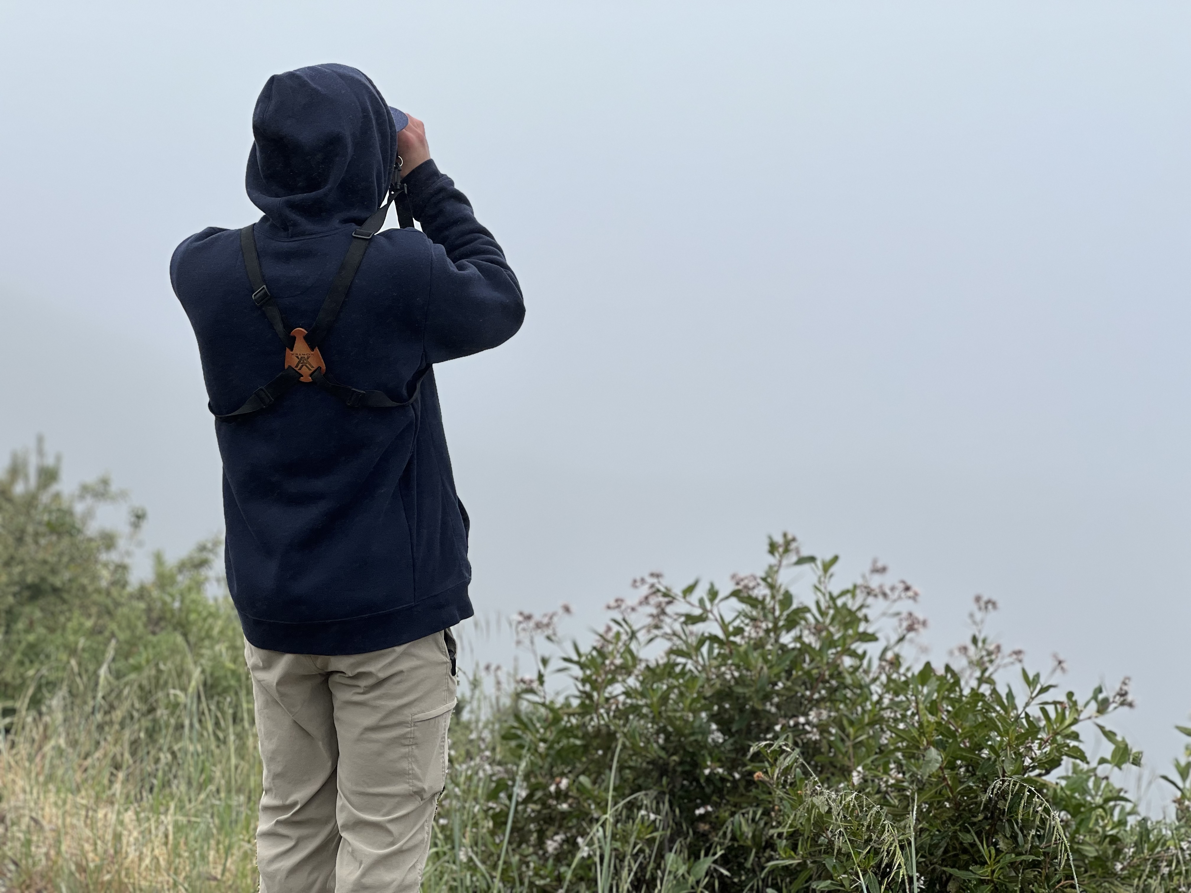
I left my cabin at 6:40 AM and 35 minutes later I pulled into the dirt parking lot on the ridge that straddles Santa Cruz and Santa Clara Counties.

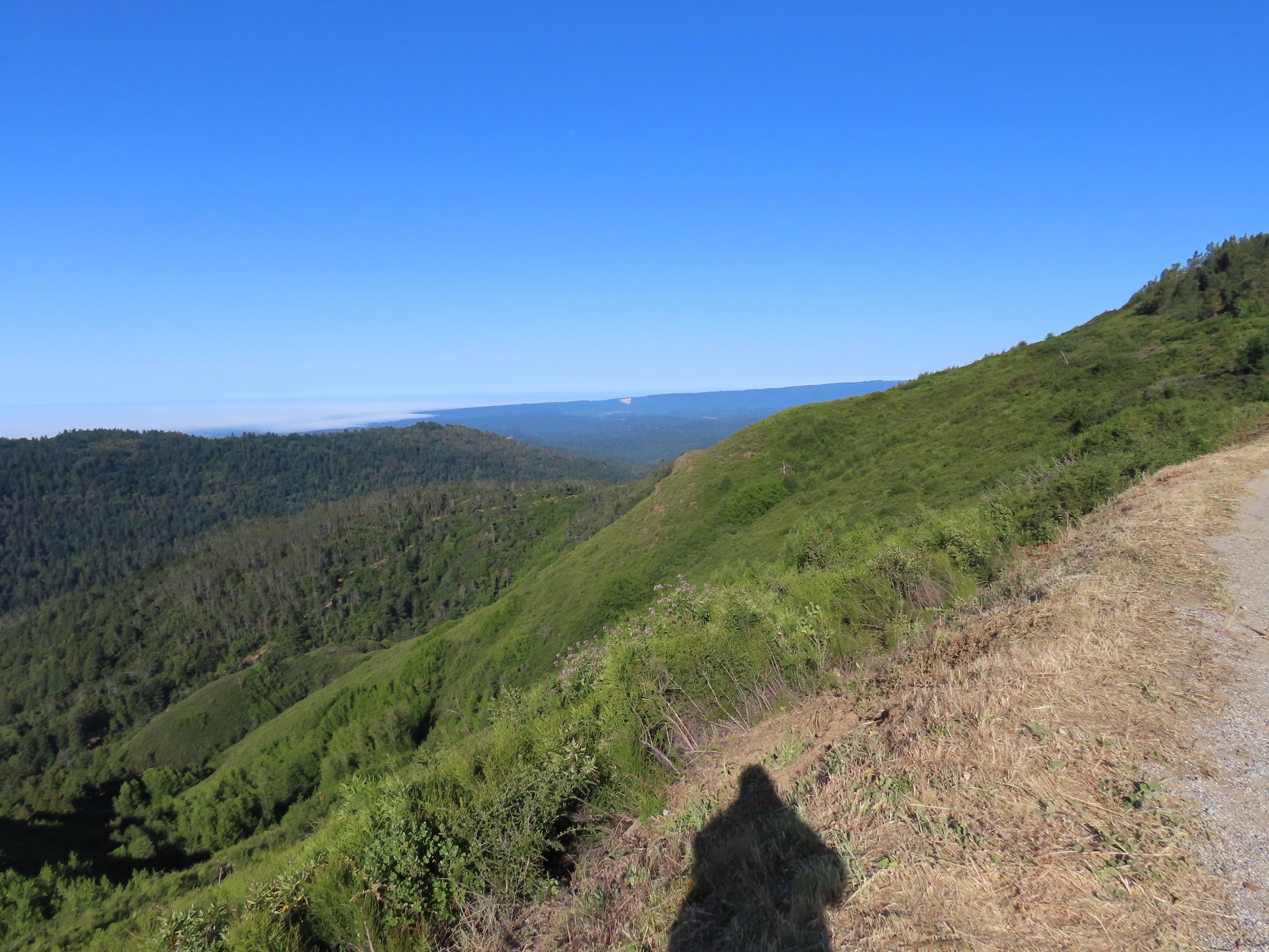
It can be very windy and hemmed in by dense fog up here but not today. I could look down and see fog covering Monterey Bay. Today it was clear and warm without much of a breeze. In fact it was already getting warm.

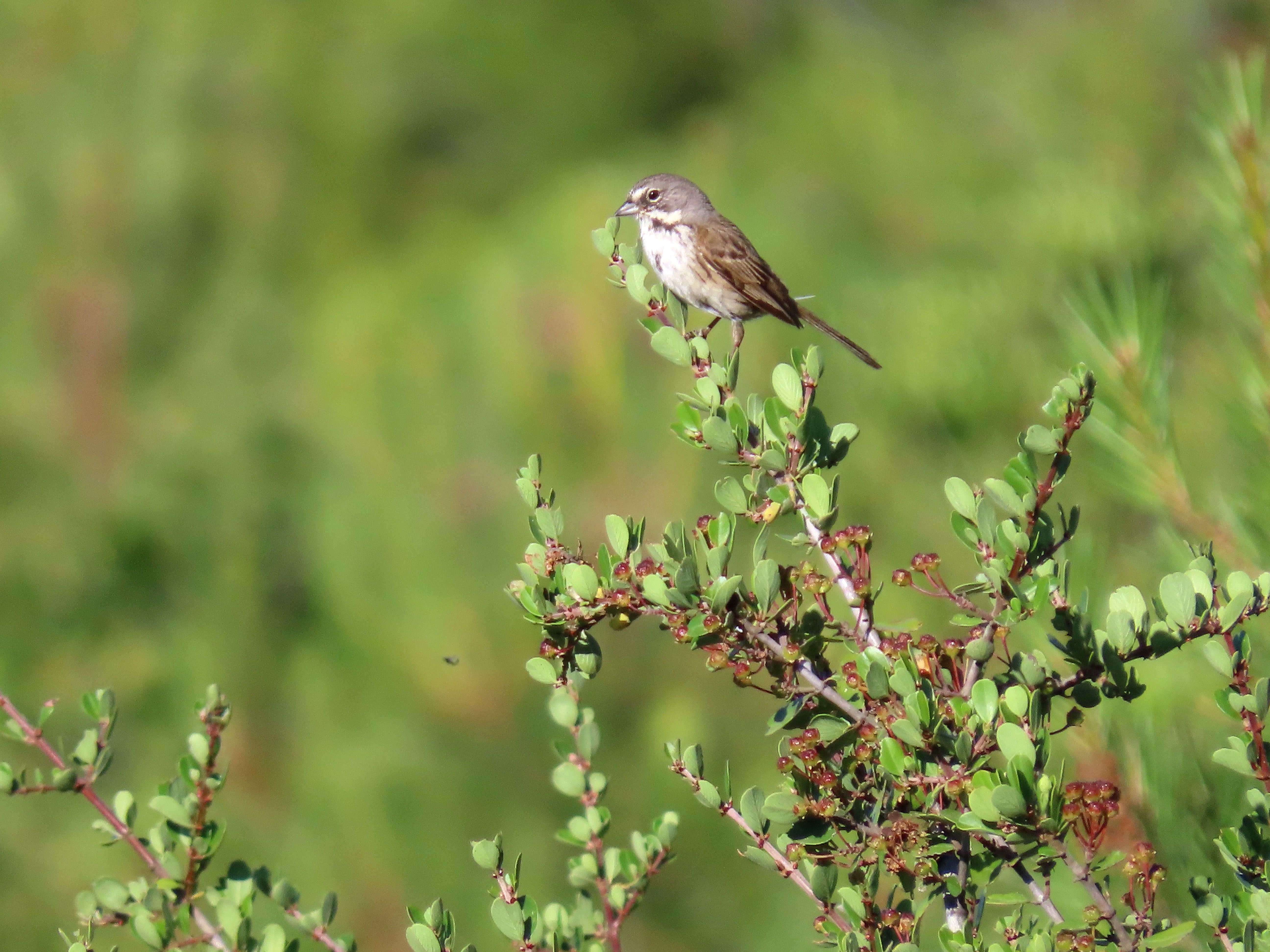
My target was the pair of Bell’s sparrows that had recently been seen here since mid May. This would be a Santa Clara County bird for me.

I walked down Mt. Madonna Road and aside from singing spotted towhees and wrentits, and a far off babbling California thrasher, it was pretty quiet. I did not hear or see any black-chinned or Bell’s sparrows.

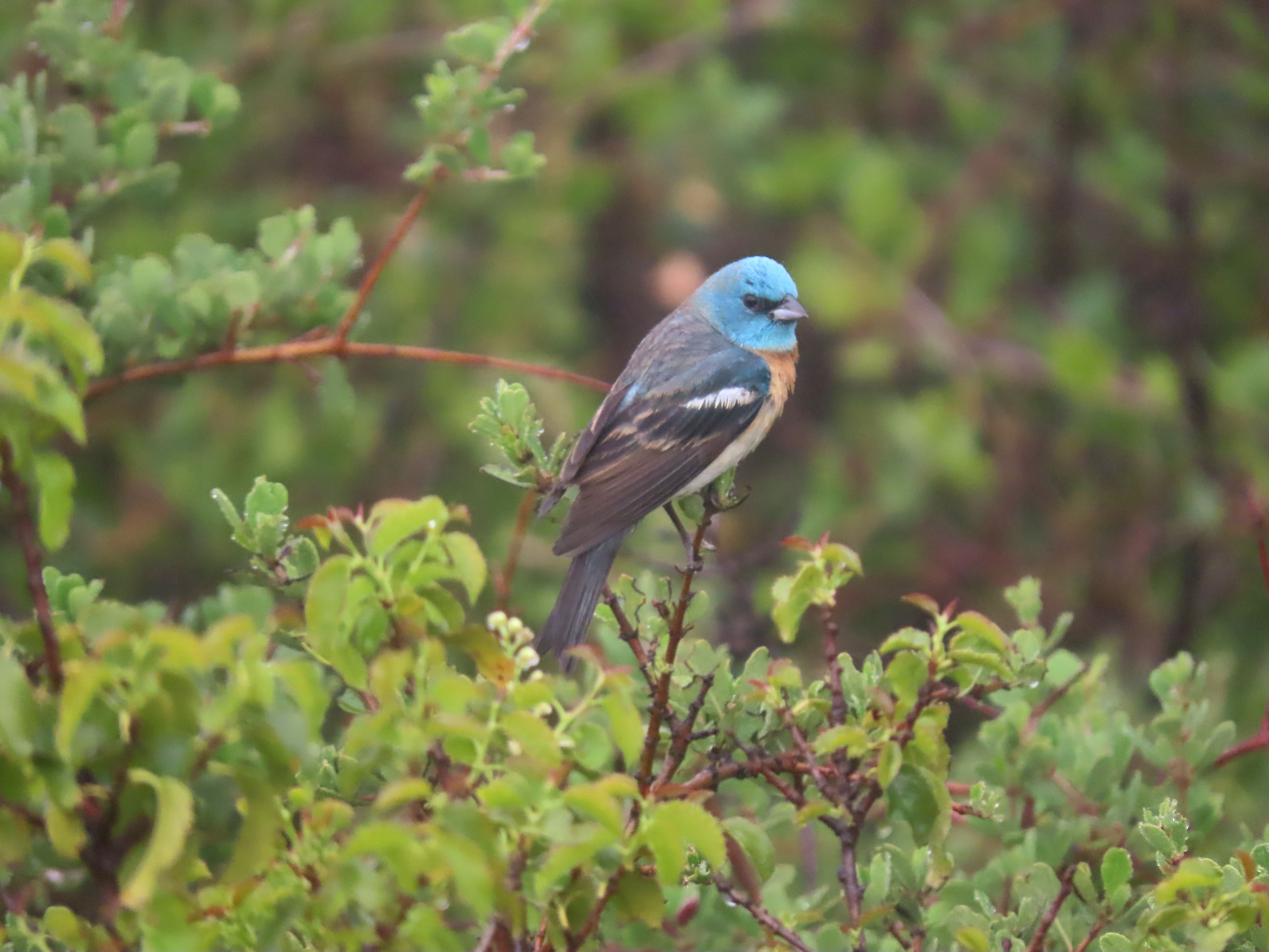
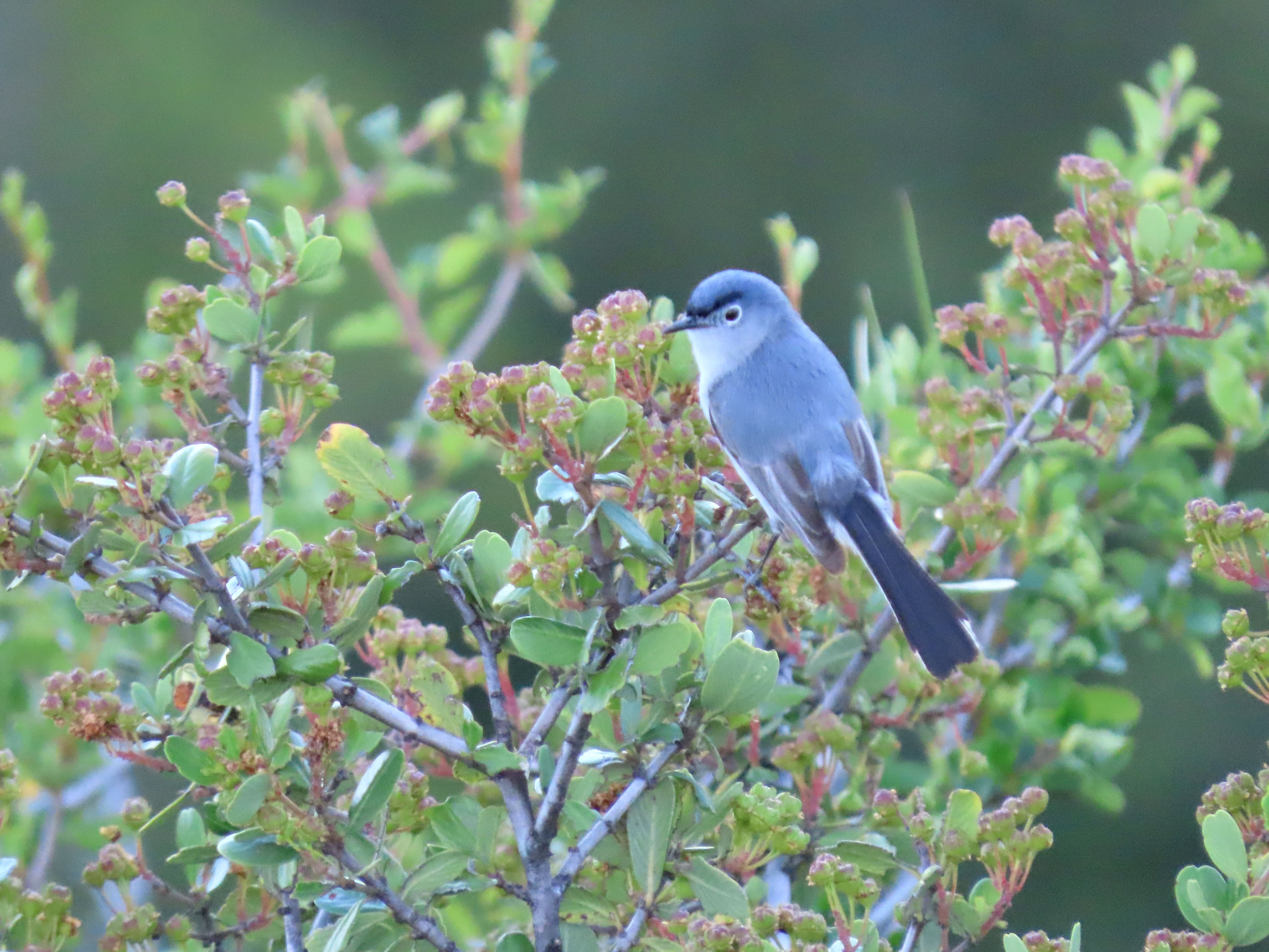
On my way back to the parking lot I first heard and then saw a blue-grey gnatcatcher.

Blue-gray gnatcatcher.

As I headed to the parking lot there were now six other birders in the area, looking for the Bell’s.

As I reached my car a pair of birders had just spotted a pair of Bell’s sparrows right from the parking lot. So I figured I’d stay a bit longer.

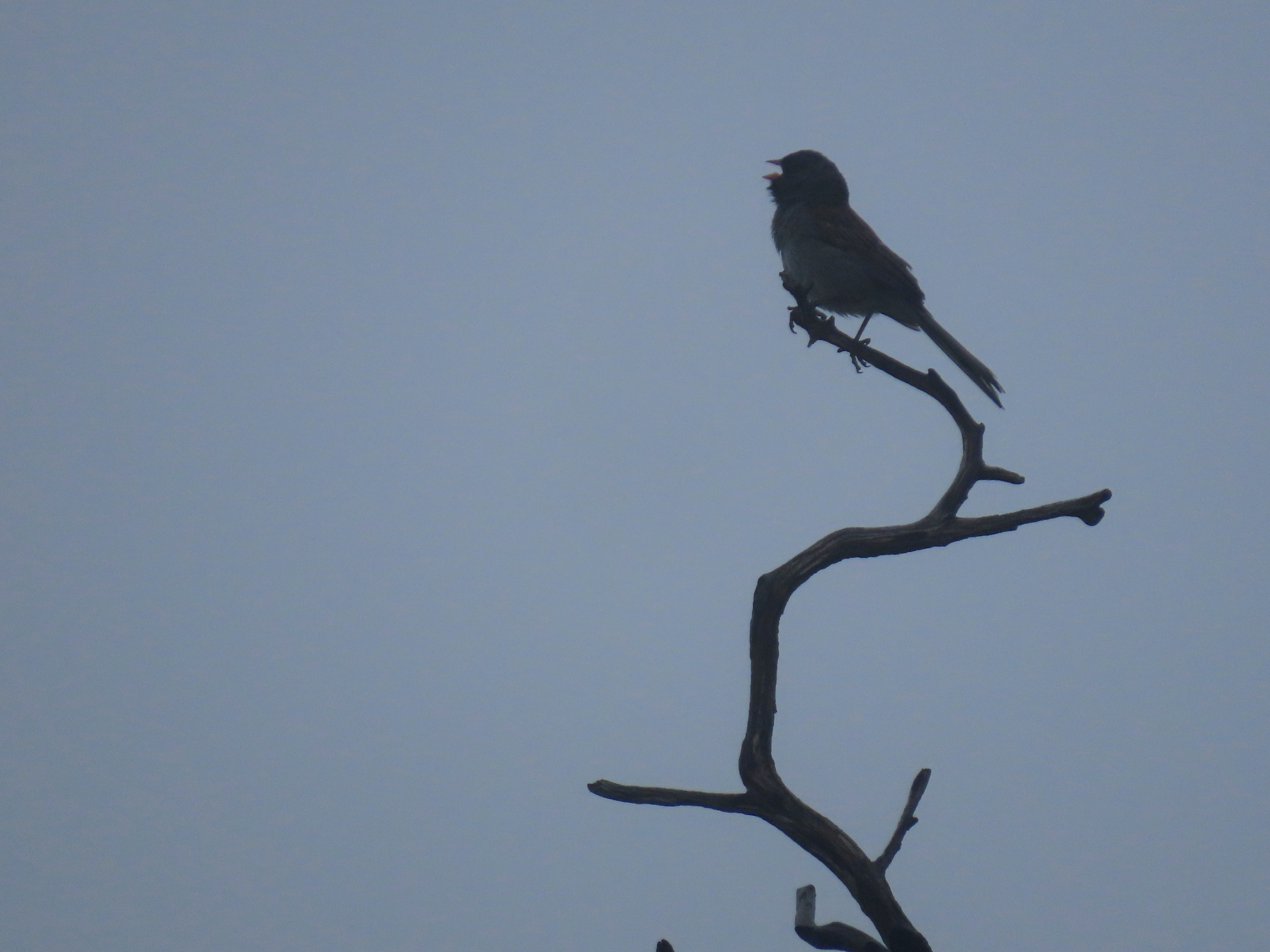
I was rewarded about five minutes later when a bird flew towards me and perched on a nearby bush in front of me. Bell’s sparrow! A new county bird!
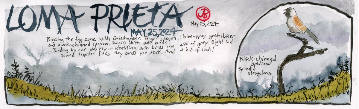
Bell’s sparrow.

Sketching Notes

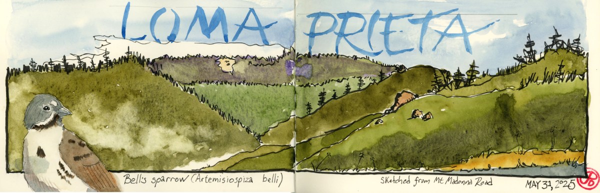
Loma Prieta Ridge is one of the best panoramic views in Santa Cruz County. So I took a pause in Bell’s sparrow spotting and opened my panoramic watercolor journal to capture the scene.

What a view, best in the county!

I left the lower left side blank. I initially was going to add a Bell’s sparrow but I hadn’t seen one yet. So I thought I would add a blue-grey gnatcatcher to that corner, based on my field photo.

After seeing the Bell’s from the parking lot, I returned to my original plan and the result is my featured sketch.

Image

Summit Fog Birding

Early on a Saturday morning, Grasshopper and I headed up on winding Summit Road. Our birding destination the Bay Area birding hotspot: Loma Prieta and the “Saddles”.

About 10 miles in from Highway 17 the road devolves into a pock-marked rural ramble as it threads its way over the spine of the summit, defining the line between Santa Cruz and Santa Clara Counties. Near the junction with Loma Prieta Way the asphalt ends entirely and the graded dirt begins.

We parked in the dirt lot, light drizzle covering the windshield. This didn’t look like great birding weather. Wet, windy, with limited visibility. Would be able to pick out a blue-gray gnatcatcher or a black-chinned sparrow in these conditions? Both would be lifers for Grasshopper. And it was my goal to get him life birds number 321 and 322.

Grasshopper looking at water droplets.

We got out of the car, geared up, and surveyed the wall of grey to the west. I had a feeling we would be birding by ear, something Grasshopper can always get better at.

We headed down Loma Prieta Way stopping and listening as we went. Wrentits, spotted towhees, a far off California quail but none of our target birds, so we walked on. Luckily the damp, windy weather did not stop the birds from their spring songs.

After we were about a quarter of a mile down from the parking lot I heard something different, a cat-like mewing on the upslope. This was not the fooler Bewick’s wren (who had almost fooled me a few yards back) but one of our target birds!

Now we needed to get eyes on it. The younger eyes of Grasshopper found it out on a tree branch: blue-gray gnatcatcher!

After getting so-so looks of the energetic gnatcatcher, we headed a little further down and I first heard our second target bird far up the hill. An accelerated bouncing ball of a song.

I willed the bird down by saying a little prayer to the Birding Gods and soon enough the sparrow flew over the road and landed downslope on a charred snag. Our binos swung up and we enjoyed prolonged views of a singing male black-chinned sparrow!

The foggy silhouette of one of our main targets: the black-chinned sparrow singing on a burnt snag. The black-chinned is an early adopter of burnt out areas.

Lifer number two for Grasshopper!

By this time we were coated with dizzily dampness and we headed back up to the parking lot. On the way up Grasshopper saw birds flying below the road. It was a pair of lazuli buntings! This is not a lifer for me or Grasshopper, but it has been a while since I have seen or heard this neotropic migrant.

A stunning male lazuli bunting. I never get tired of seeing and hearing this bird.

This is why birding remains a passion for me. I’m still excited to see and hear birds that I have seen many times before but the excitement remains.

And so it will always remain.

Image

Professor John Montgomery and Evergreen

Previously I had written about aviation history above the skies of Aptos on the Monterey Bay. The man who designed the glider was a Professor John L. Montgomery.

Montgomery had a long history of flight development in California. He is overshadowed by aviation developments in Europe and on the East Coast. And his accomplishments are eclipsed by the Wright Brothers, who must have had a better PR man.

There are a few reasons for this. Montgomery had trouble securing patients for his flight inventions and being far away on the west coast and far from the national media in New York and Boston meant that his exploits didn’t get the same coverage as the Wrights. Even though he flew a glider 20 years before the famous Wright Brothers.

I wanted to visit and sketch the hillside where be flew his last glider. This is in the Evergreen neighborhood of East San Jose. The hillside is now named Montgomery Hill in his honor and is behind present day, Evergreen Valley College.

I arrived at the collage early on Sunday morning, free parking! My plan was to walk up to the observatory and sketch Montgomery Hill.

The Observatory at Evergreen Valley College.

I positioned myself so I could sketch the dome of the observatory in the foreground and the hill that stretched off into the distance (featured sketch right).

The hill before me was where Montgomery did many test flights with the glider her designed. The glider was named after this area: Evergreen.

A 1911 photograph of Montgomery flying the Evergreen, shortly before his death. The location is now called Montgomery Hill.

In was on this hill on October 31, 1911, that Professor Montgomery crashed his glider Evergreen, and died of his injuries. He was 53 years old.

Montgomery Hill, the sight of Montgomery’s last flight.

John J. Montgomery is starting to get the recognition in aviation history that he so rightly deserves. In the Evergreen neighborhood at the intersection of San Felipe and Yerba Buena, there is a 30 foot wing that stretches up to the sky (featured sketch).

This Public art is titled “Soaring Flight” (2008) by artist Kent Roberts.

On an interesting side note, sculptor Kent Roberts (1947-2019) was a Bay Area artist. Before attending the San Francisco Art Institute, he served as an officer in the US Navy aboard an aircraft carrier. The ship’s name: the USS Kitty Hawk.

Uncanny.

Image

Gates of Heaven, Santa Clara County

On film critic Roger Ebert’s list of the Ten Greatest Films of All Time, only one film is an American documentary (two out of ten films are documentaries).

This is the Errol Morris 1978 documentary Gates of Heaven. The film is about two California pet cemeteries, one in the Napa Valley and the other in Los Altos.

The film opens in Los Altos at Highway 280 and Foothill (I grew up two highway exits away). This is the site of the Foothill Pet Cemetery and Morris spends time interviewing the founder Floyd “Mac” McClure and other investors in the pet cemetery.

Some of the clients of the cemetery are also interviewed, including the woman with the “singing” pup and for comic relief, the manager of an animal rendering plant.

Mac has a lot of passion for his dream of opening a pet cemetery, he puts love above profit but one feels he isn’t the best businessman. The owner of the land, a Mr. Dutton, decides to sell the land to a real-estate developer and the pets, all 450, have to be exhumed and reburied in the another pet cemetery (Bubbling Well Pet Memorial Park in Napa Valley).

The second part of the film interviews the Harberts family which runs the Bubbling Well Pet Memorial Park. But not before one of the best monologues in documentary history from a Los Altos elderly neighbor, Florence Rasmussen, who lives across the street from the cemetery.

The documentary was filmed in the summer of 1977 and I was in search of the location of the cemetery on a rainy late morning.

Looking at maps, I noticed a trail (Hammond-Snyder Loop Trail) up to a hill that would give me a view of area to the south of Highway 280 and east of Foothill.

I set off on the muddy trail past a red-tail hawk perched in an oak. There was a light drizzle. In about five minutes I found myself on a small hill partially fenced in with an interpretative sign.

Looking to the north I knew I was standing at the cameras location from the panning shot at the beginning of Gates of Heaven.

A screen capture of the first panning shot in the film. The green water tanks are still there. The bridge in the foreground right is Cristo Rey Drive over the Southern Pacific Permanente Cement Plant branch line. In the background is Highway 280.
This screen capture, from the same panning shot as above, comes to rest here: the location of the Foothill Pet Cemetery between Cristo Rey Drive and Highway 280.
Here is the same view of the cemetery today. The distance fades into drizzling skies. There are more houses and trees than there were in 1977. The roads are very much the same as 47 years ago.

I pulled my panoramic journal out of my pack and quickly began a pen brush sketch of the scene before me, my lines blurred and smudged in the drizzle. These “happy accidents” became part of the sketch.

Parts of the scene were still recognizable: the green waters tanks, the railroad, the Foothill Blvd entrance and exit ramps, Cristo Rey, and Highway 280.

Where the pet cemetery was located is now a housing development and the trees now seem much taller and more plentiful than when the panning shot was filmed here almost 47 years ago.

Do the residents of Serra Knoll Estates know their houses are built on the site of a pet cemetery?!
Oddly enough there is a Catholic Cemetery called “Gate of Heaven” just down the road from the former Foothill Pet Cemetery. Did Morris get the idea for his film’s title here? Maybe only he really knows.
Image

The Rengstorff House

The Rengstorff House was one of the first houses built in Mountain View.

What piqued my interest in the circa 1867 house was an article in a Palo Alto weekly newspaper that a fellow teacher gave me. The article told the story of the Rengstorff House and the link to the countries largest mass kidnapping. What?!

The house was built by businessman Henry Rengstorff, a German immigrant that came to California to strike it rich during the Gold Rush. He made his money my farming and buying up land. He died in 1906 and afterwards, members of his family lived in the house until 1959.

The Rengstorff House at its new location.

The land that the house was on, was sold to a land developer. In the mid 1970s, three young men had the dream of buying the house, (which had been abandoned and was now dilapidated) moving it to a new location, restoring it, and then living in it because they had always wanted to live in a historic mansion.

The young men were from the affluent communities of Portola Valley and Atherton and came from wealthy families.

So they hatched a plan to raise funds to buy the Rengstorff House.

On July 15, 1976 in the tiny farm town of Chowchilla, California three armed assailants hijacked a school bus containing 26 children who were returning from a swim party at the local community pool. The bus was hidden in a local slough and the bus driver and children were transferred to two vans and driven 100 miles away to a rock quarry in Livermore.

The children and driver were transferred to a truck trailer that was buried in the ground and the entrance was covered. The kidnappers left and planned to ransom their victims for $5 million. When they called the Chowchilla Police Station with their ransom note, they couldn’t get through because the station was flooded with calls by concerned parents.

The children and driver escaped and the son of the owner of the rock quarry became the number one suspect.

All three kidnappers were captured and later sentenced to life in prison. All three are now out of prison on parole.

They were not able to buy the Rengstorff House and it was later relocated to Shoreline Park in Mountain View and is now a museum.

In between rain showers, I headed down to Mountain View to sketch the historic house. When I arrived there was a turkey vulture perched on the front gable.

After my sketch I walked around to the side to see if I could get a tour of the interior. The house was just closing for a private event.

I mentioned the recent article to the docent. She told me there were inaccuracies in the article and the writer didn’t even interview any staff at the museum about the story. When I asked about the Chowchilla Kidnappings, she replied, “We don’t talk about that.”

No wonder the Palo Alto Weekly didn’t consult the museum.

Image

The Valley Part 1

Silicon Valley is probably a good, in many ways. The Valley of Heart’s Delight was a glory. We should have found ways of keeping the one from destroying the other. We did not. . .

-Wallace Stegner, Pulitzer Prize-winning novelist

 The children’s book of poetry, Where the Sidewalk Ends by Shel Silverstein was a popular birthday gift at many birthday parties when I was a child growing up in the 1970s. But in the Santa Clara Valley where the sidewalk literally ended, the apricot and cherry orchards began.

Sunnyvale in the 70s was in a state of transition. It was the struggle between the Valley of Heart’s Delight and Silicon Valley. When I was a kid, it seemed that the Valley of Heart’s Delight had the upper hand, but the lone apricot tree in our back yard, told that the ascendancy of Silicon Valley was clearly underway. The apricot orchard had made way to the track homes that housed the families that fueled the early industries of Silicon Valley, and this lone tree, which my brother and I posed in for family Christmas cards, was the last reminder. My family, on Cormorant Court, was one of those early Silicon Valley families.

After work, during the final warm days of summer and fall, my father would put me on the back of his bicycle and we would retrace his route to work along Fair Oaks Ave. We ascended the pedestrian walkway over the Southern Pacific train tracks. Here we would look down into the Schuckl Cannery on the side of the tracks. To this day I can recall the din of the conveyor belts, the frenetic energy of the forklifts bringing in the valley’s harvest, and the smell of the burning train brakes as a commuter train eased into Sunnyvale Station down below.

IMG_4778

Blenheim Apricots at the Sunnyvale Heritage Orchard. This preserved orchard is on ten acres and contains about 800 trees. At it’s height Sunnyvale’s orchards included eight to nine million trees.

Then there was the oft-told story of the day my dad drove to work along Fair Oaks Ave  and he saw a cherry orchard  being uprooted, with fruit still on the trees. “What a waste” was the phrase that usually concluded the story. Those orchards are now rows and rows of condos with names like Cherry Orchard and Orchard Gardens Apartments.

Gone are the millions of apricot and cherry trees, the canneries, and the migrant workers that picked fruit each summer and fall. What is left are like islands of preserved orchards in Sunnyvale, Santa Clara, and Los Altos, a mere shadow of the agricultural area that once attracted motorists each spring to view the millions of blossoming trees.

IMG_4769

In 2001 the Sunnyvale Orchard Heritage Park Interpretive Exhibit was opened. It was built along side the Heritage Orchard with interpretive signs that told of the rise and fall of the Valley of Heart’s Delight. My father’s name is immortalized on one of the signs in the Hertitage Park. He helped to create the park so future generations would remember the valley’s past. 

On a recent returned to Sunnyvale on a May morning, that was already starting to feel like summer, I sketched a few apricot trees at the Orchard Heritage Park. On my way I drove down De Anza Boulevard, past the ghosts of my childhood, past unrecognizable buildings and storefronts, past the Apple Campus. So much was physically gone. An orchard, a favorite restaurant, a father. What does it mean when your past no longer physically exists?

Over the next few blogs I will explore the changing face of The Valley.