A towhee had taken up winter quarters on Laguna Creek Beach. This beach is close to Davenport on Highway One and 10.2 miles from my cabin (I checked).
Two towhees, a large, sparrow-type bird, are common on the California Coast. The appropriately named California towhee and the spotted towhee. Neither of these two species were the reason I headed north on Highway One on a Saturday morning.
I was here, hiking into a headwind on a sunny but blustery winter’s morning, to see a rare towhee on the coast. It is said that every bird is rare somewhere and the green-tailed towhee is rare here on the California coast. I have seen many green-tailed towhees at elevation in the Sierra Nevada Mountains but I was going to attempt to add this species to my Santa Cruz County list. I wanted a green-tailed towhee at sea level!
Who knows how long this wayward towhee had been on the Santa Cruz Coast but on January 12, 2021, two birders happened to be birding this beach and also happened to know that this towhee was out of place in this location. They reported it and other birders searched for it, some getting momentary looks of this sulky towhee. There where even less quality photos of this ever-moving and scrub-loving bird.
So the bar was low for a quality sighting and capturing great photos was an even lower bar. That’s if I didn’t whiff on this towhee altogether, for any sighting is never guaranteed. As one birder noted, “Ducked into a bush and never reappeared.”
The bird was seen on the northern part of the beach, north of the creek and just left of an “AREA CLOSED” sign. The sight was described as being where the sand meets a six foot high cliff. So here I was, peering into the bushes. Flanked by two nude male sunbathers.
The first bird I saw was a blue-grey gnatcatcher as is foraged and called at eye level in the coyote brush.
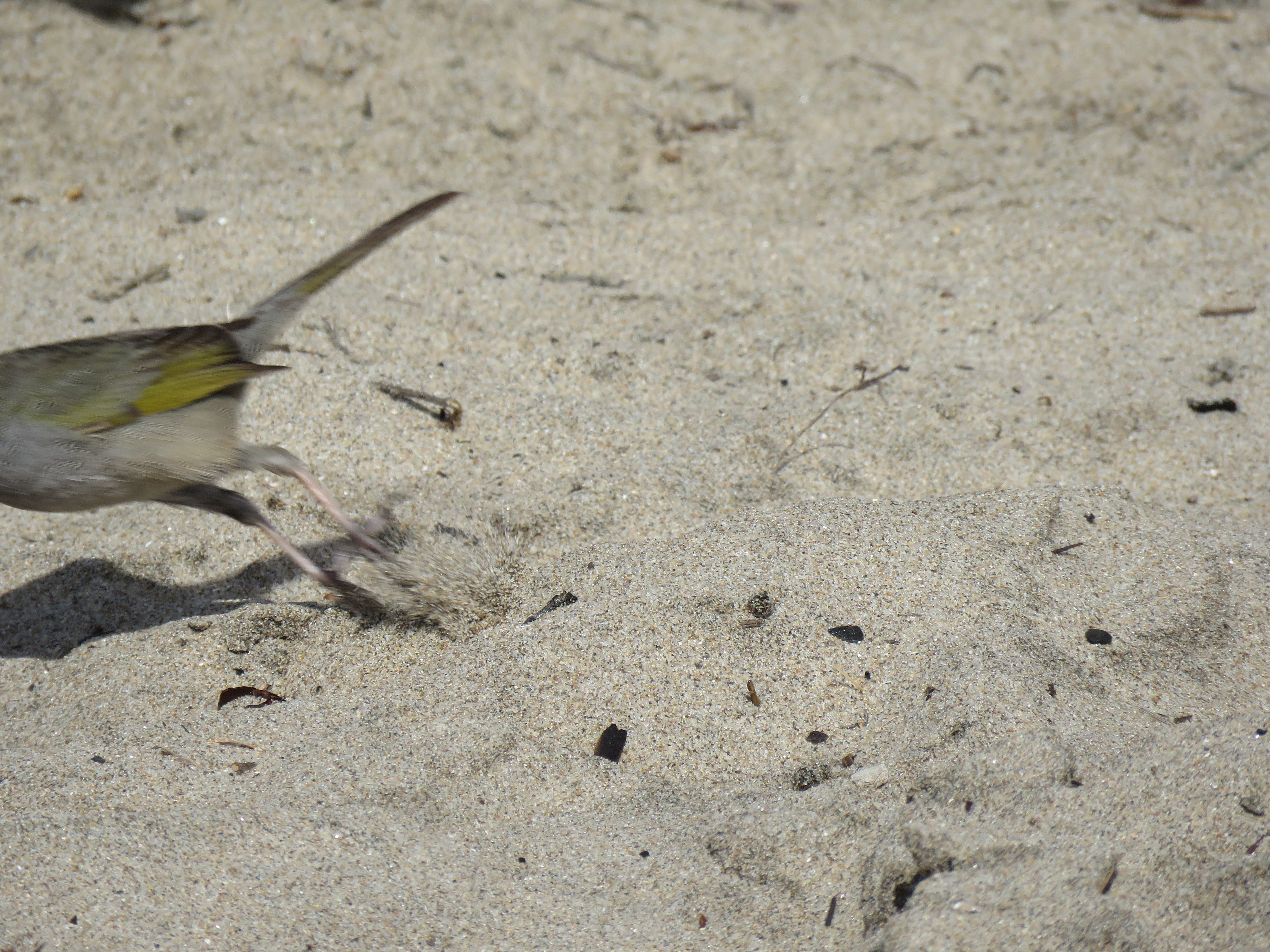
I turned on my bluetooth speaker and selected a recording of the towhee’s “cat-like ‘mew'” call. I hit play and after a single call, the green-tailed towhee shot out of a bush in front of me and stood before me on the sand. Sometimes birding is just this easy.
I had amazing views of the towhee as it foraged on the sand and I was able to get great photos in amazing light. The towhee stayed out in the open for about two minutes before disappearing into the coastal brush.
This photo proves just how elusive the green-tailed towhee can be! Now you see it, now you don’t. You have to be quick to photograph this bird.The green-tailed towhee with it’s rufous crest, white throat, and greenish wings. This bird almost seems to be posing for me.The profile view would have made Roger Tory Peterson proud. Here you can see the greenish tail.
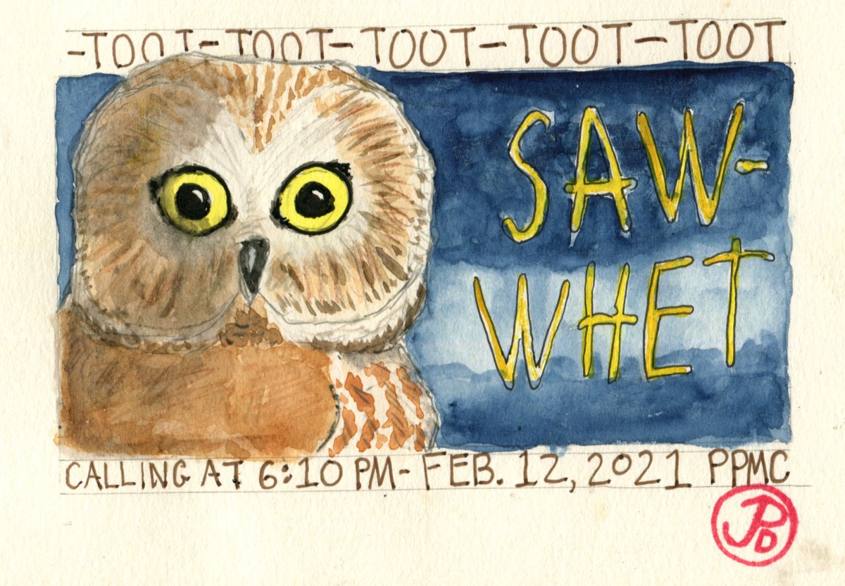
In mid- January, my neighbor from down the hill from my cabin, emailed me that she heard an owl calling, just after dark.
She thought it could be a saw-whet or a western screech-owl. On following evenings the mystery owl called again and again, just after dark. She confirmed that she thought that the owl calling was a northern saw-whet owl (Aegolius acadicus)!
This would be an amazing Santa Cruz County bird to add to my list and especially so to hear this diminutive owl in my own backyard! Well, close to it anyway.
The Northern saw-whet owl is can be common or uncommon resident of the California coast, favoring mixed conifers and deciduous woods. This owl may be much more common than believed because if it isn’t calling, this owl goes undetected. It is one of our smallest owls with a length eight inches and weighing in at 2.8 ounces. In other words, this owl weights as much as three standard sized envelopes.
The northern saw-whet gets its common name because it’s incessant “toot-toot-toot” territorial call that reminded early ornithologists of the whetting or sharpening of a saw; a common sound in the forests as lumberjacks felled trees to fuel a growing nation.
I have never heard a saw-whet call in Paradise Park. This may be because wildlife has been displaced by the destructive CZU Lighting Complex Fire. This fire burned in the late summer of 2020 for 44 days, consuming almost 400,000 acres of the western side of the Santa Cruz Mountains. Some of those animals are now wildfire refugees and are now establishing a new territories.
I planned to head down to Santa Cruz and do some owling, to see if I could confirm the existence of a saw-whet in Paradise Park. So I set out at 5:30 PM and walked around as the diurnal birds stopped calling, one by one as they sought out their nighttime roosts. The last diurnal call was the “chip” of a California towhee. It was now time for the night shift.
I centered my search at the picnic grounds. This is where my neighbor had recently heard the saw-whet. Now it was a matter of waiting a time with patience. A time to focusing the senses, to filter out the sounds of traffic on Highway 9 and seek the repetitive toots of the saw-whet.
At 6:10 I heard the first call of the saw-whet. It seemed distant and tough to locate. The saw-whet’s call is very loud for such a small bird, it can be heard from half a mile away.
I moved along the road to try and locate the owl, but as always, owls are elusive. At times it seemed the saw-whet was close and at other times far. As if the owl was frequently changing locations. In reality the owl was probably changing the dynamics of it’s song. It would be silent for a short time and then resume it’s name token song. I now had a new Santa Cruz County bird in my own backyard!
On Saturday evening, I went out for another owling ramble, to reconfirm the saw-whets presence in my world. Would I hear it two nights in a row? I also wanted to get a better sound recording of the owl. The evening before I recorded a faint but distinctive recording.
This time I set out a little later. I was at the picnic grounds at 6:30 pm and it wasn’t long before I heard the saw-whet calling up the hill.
I walked up the road toward where I thought the sound was coming. Hanging from my belt loop was my bluetooth speaker (an indispensable piece of equipment for any tropical bird guide).
I was going to use a recorded call of a call-whet to try to bring the owl closer so I could get a better recording of it’s call. In birding terms this is called using “playback”. When I played the recording through the speaker, the saw-whet seemed to accelerate it’s song. The call was getting louder as if the owl was coming closer to my location.
An owl’s flight is silent so I could not hear if the saw-whet was flying towards me. But what I did hear was the owl’s wings brushing against the branches above me. I was able to get two recordings with my iPhone and then I left the saw-whet to it’s “day”of establishing it’s territory and hunting for small rodents.
I headed back to my cabin, satisfied with my night revels but I had one last trick up my sleeve. I stopped outside my neighbor’s house and I turned my bluetooth speaker on and played the saw-whet call at full volume! Within a minute, she came out surprised that it was just me and not a saw-whet. I thanked her for telling me about the saw-whet owl in our backyard!
I’ve never been a huge county birder. County birding is keeping track of how many species seen within the boundaries of a single county.
County lines are a purely human made boundary that birds fly over but it is a fun challenge to try to see as many species in a chosen county. The three counties that I focus on are San Francisco, San Mateo, and Santa Cruz. I set the modest goal of seeing 200 species in each of the three county. Over the past year and a half I have tallied over 200 in each county.
But for Santa Cruz I wanted to see if I could become a member of the Santa Cruz Bird Club’s “300 Club”. To reach 200 took awhile and I knew to reach 300 species in Santa Cruz County would take time, persistence, patience, and luck. On the Martin Luther King Jr. three day weekend I thought I would attempt to add few birds to my Santa Cruz County list.
Now these birds were not especially rare nor were any of these lifer birds for me but they had somehow evaded my binoculars in the 831 area code. There are: snowy plover, snow goose, blue-winged teal, and American dipper.
I started my search at the very southern edge of Santa Cruz County at Pajaro Dunes. Pajaro Dunes is a private resort housing development. When I was growing up my family used to rent a house for a holiday so I have been familiar with the area from a early age. The development is gracious enough to allow access to birders.
Once I passed through the security gate I headed to the end of the road near the Pajaro river mouth after first checking the slough near the fire station for the rare long-tailed duck but the bird had flown a few days earlier and had not been seen again.
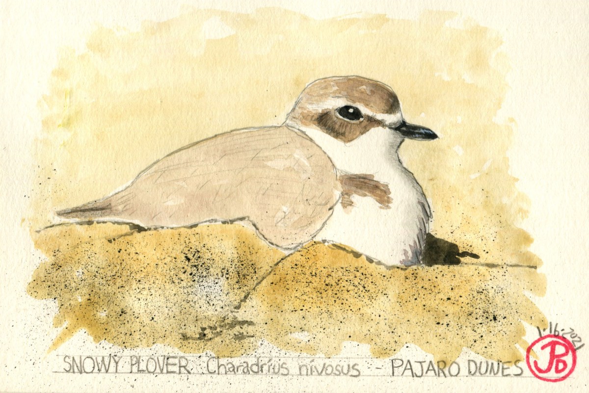
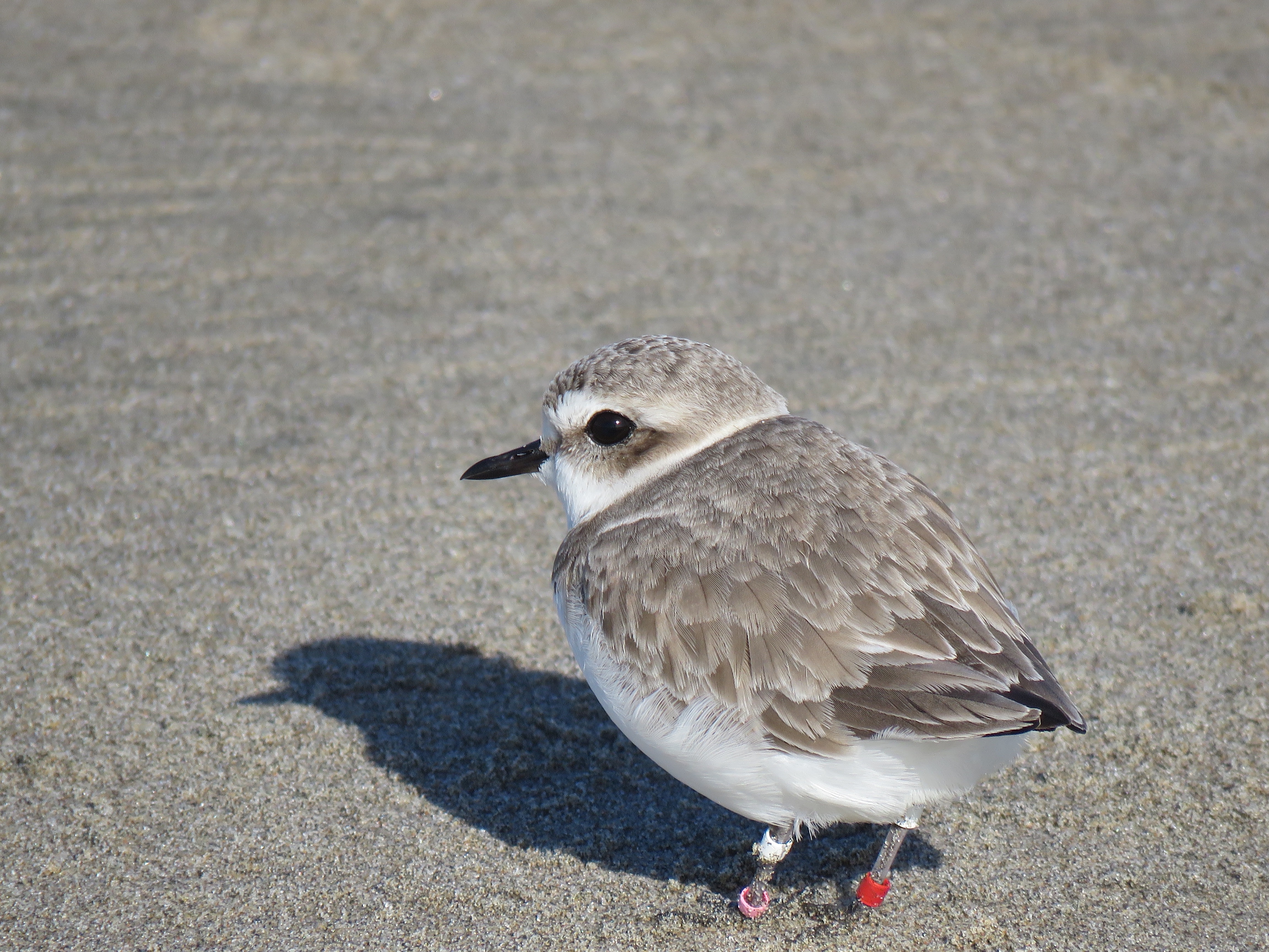
I wandered across the dunes toward the ocean looking for the small cryptic dune-plover. There were plenty of sanderlings running up and back with the tide. I checked all the flocks but no snowy plovers. I wondered how far down the beach I’d have to walk before I spotted the snowies.
I briefly checked out the backlit gull flock at the river mouth, just south of the river was Monterey County. I turned back and started walking north along the beach in Santa Cruz County. That’s when I spotted ten roosting snowy plovers which I must have walked right past.
This snowy plover is sporting jewelry. These are colored bands which helps researchers identify each individual plover. Snowy plovers are a threatened species because of habitat destruction and intensive use of their nesting grounds. Snowy ploverspopulations are declining with a recent survey estimating the total population of the Pacific Coast as 2,900.
My next stop was Struve Slough, just north of Highway One. This slough in Watsonville is a great winter hotspot for waterfowl. The waters were full of ducks, geese, and herons, but I was looking for five white snow geese. In the Central Valley, it is possible to see thousands and thousands of snow, Ross’s, and greater white-fronted geese in places like Gray Lodge Wildlife Area and Sacramento National Wildlife Refuge. But on the Santa Cruz County Coast, snow geese are a relatively rare find.
The snow geese stood out like five shining stars among the surrounding Canada geese and ducks. Another county bird was mind! Now it was time to head east to an birding hotspot: Pinto Lake.
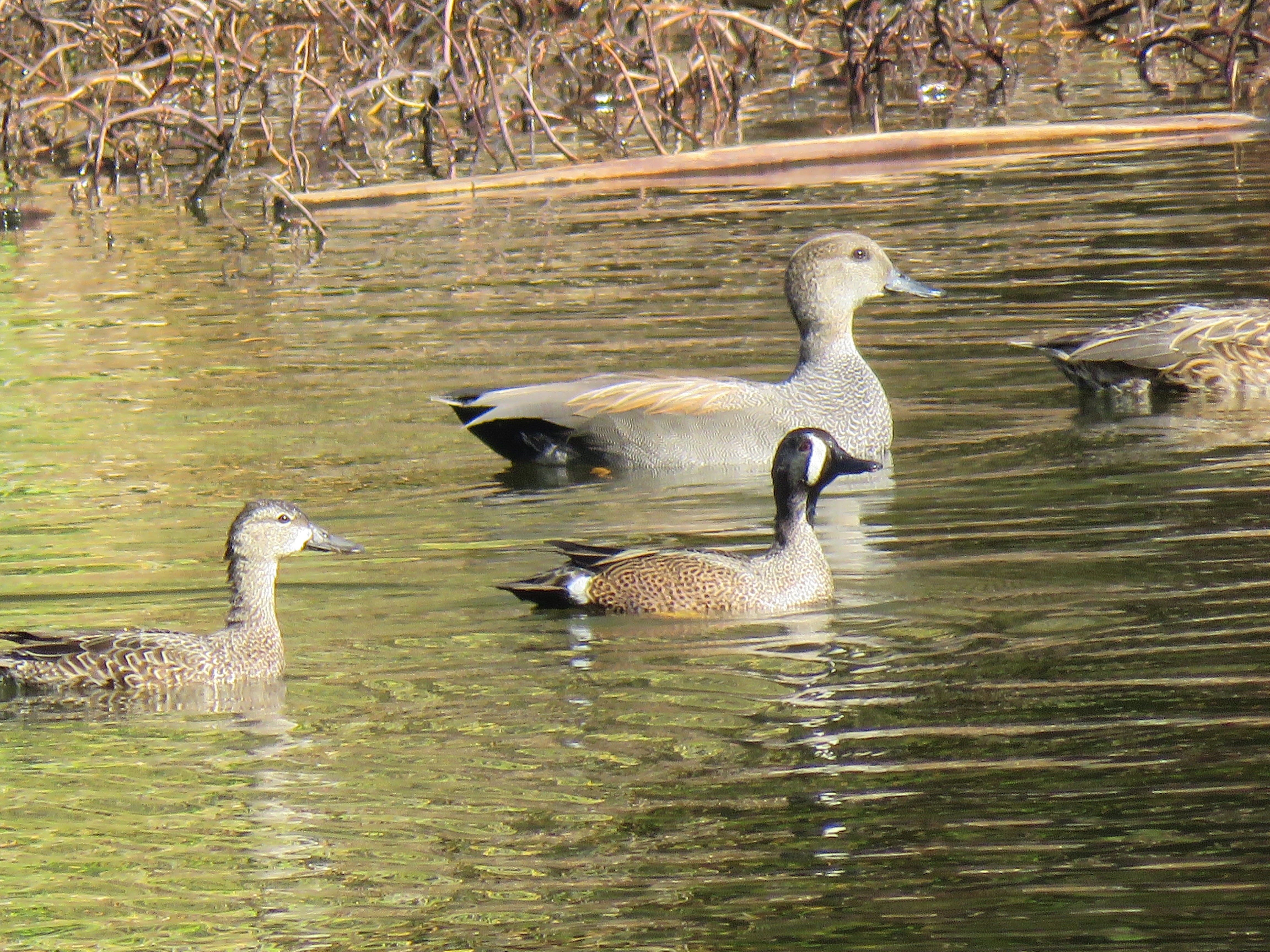
My main target at Pinto Lake was a duck I had overlooked on previous visits. This is the blue-winged teal. Without too much of an effort I found a drake and duck.
Male and female blue-winged teal at Pinto Lake. The much larger male gadwall provides an interesting size comparison.
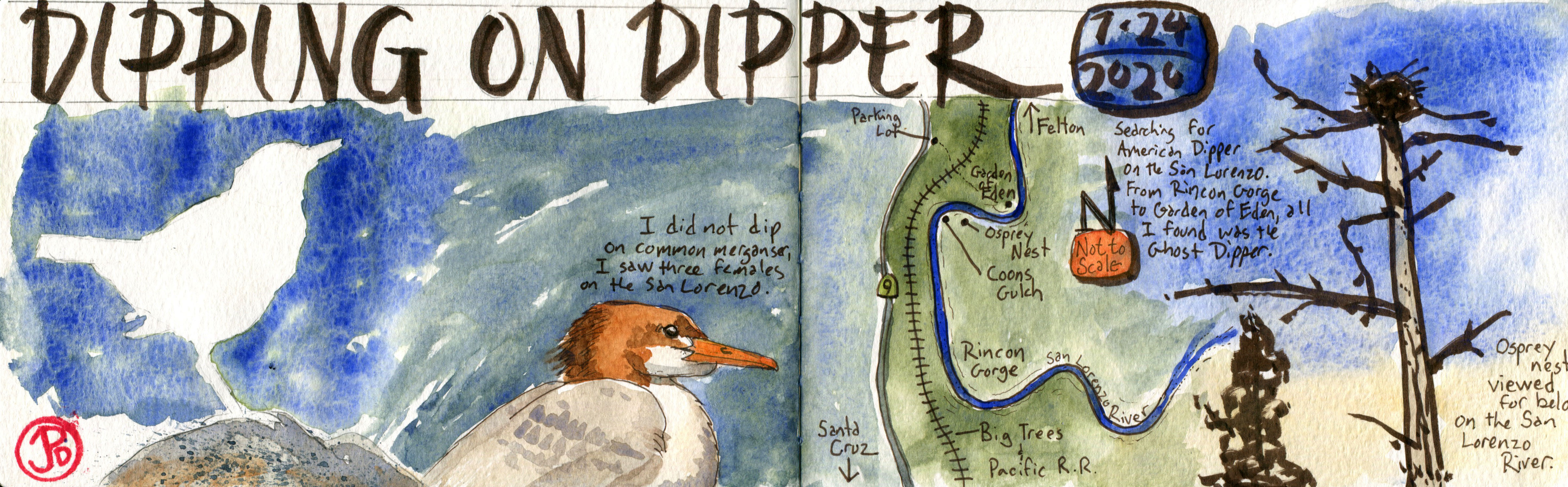
The final bird on my county wish list was turning into a nemesis bird for me. I had seen this bird many years ago flying downstream on the San Lorenzo River but it is has not seen on this river a while. So I headed up the San Lorenzo Valley. (I had not added this bird to my list because I have no record of the time I saw the dipper).
I was headed towards Ferndell Falls at the confluence of Zayante and Bean Creeks. This has been the American dipper hotspot in Santa Cruz County for the past ten years or so. But as hard as I tried, looking up Zayante and Bean Creeks, on over three visits, I was not able locate a single dipper. Nobody said county birding would be easy, in fact it can be a form of madness!! It just makes me even more determined to add this nemesis bird to my county list!
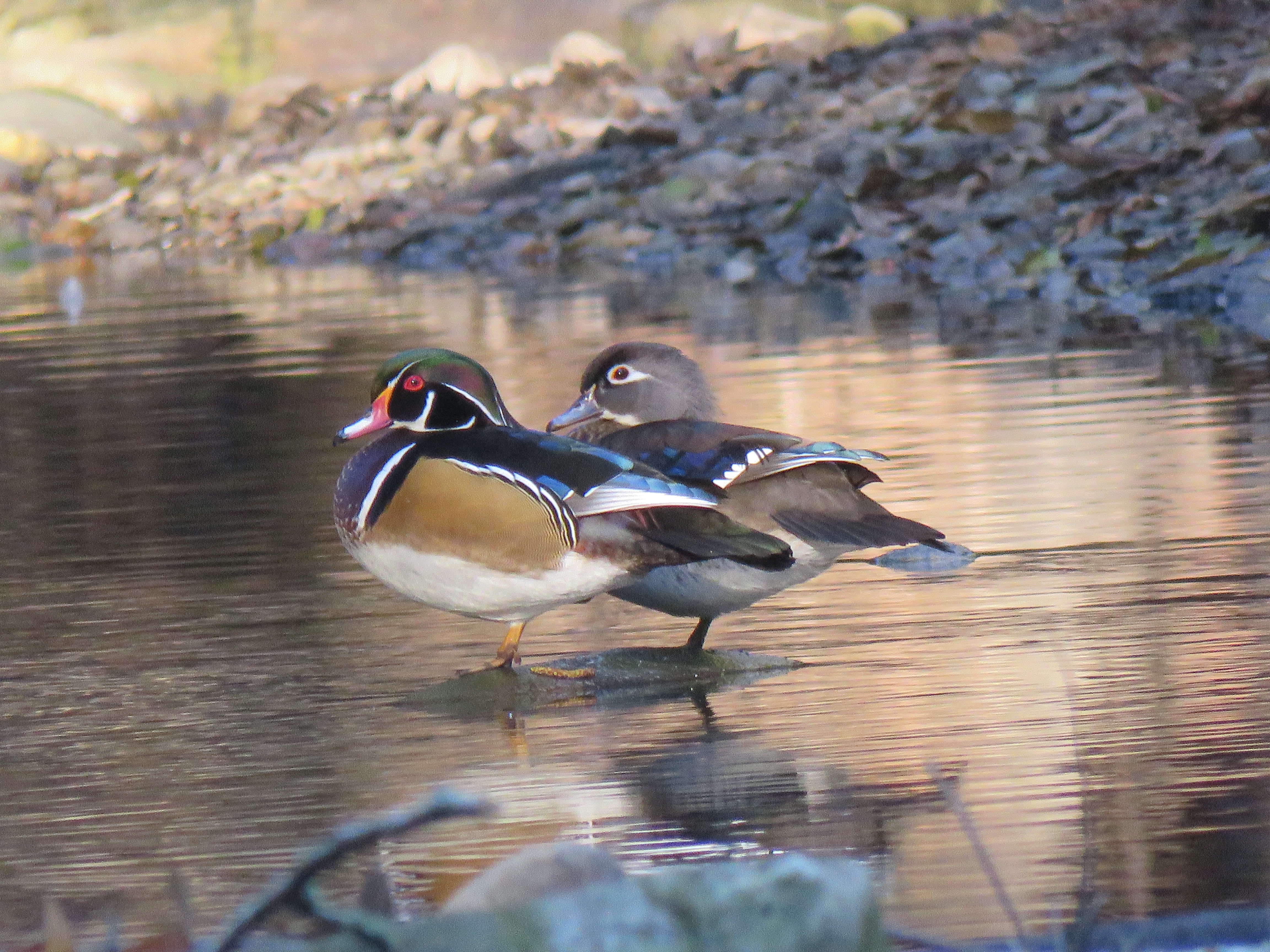
A nice consolation on my dipper search of Zayante Creek was seeing the world’s most beautiful duck in morning light. A wood duck pair.I have searched for American dipper on about ten separate occasions since last summer. Maybe the 11th time’s a charm. This spread was about my July expedition up the San Lorenzo River in search of former dipper sites. The dipper is an indicator of a healthy ecosystem because they prefer clear, clean streams and rivers. This is a sign that San Lorenzo is not so pure.
In the early morning hours of Sunday August 16, 2020, I was awoken by the low thud of thunder. A few minutes later, white light temporarily illuminated my bedroom. A summer thunder and lighting storm! This was a rare occurrence on the California coast.
I lept out of bed and headed to the deck in the same spirit that John Muir climbed up a Doug-fir to experience a windstorm! In this case my survival instinct prevented me from climbing to the top of the tallest tree in an electrical storm. Instead I stood in the open doorway.
I looked upriver and another flash of lighting silhouetted the sloping tree-line and then a clap of thunder filled the darkness. I heard the first drop of rain hit the deck and I reached my hand out from the doorway to feel the life-giving rain. It rained for a very short time, this was a dry thunderstorm.
I stood in the threshold of the back door until that survival instinct willed me to close the door and return to bed. Of course I couldn’t sleep in all the climatic excitement. The center of the storm cell was now moving over my cabin. One clap of thunder was so close that it rattled my bedside lamp.
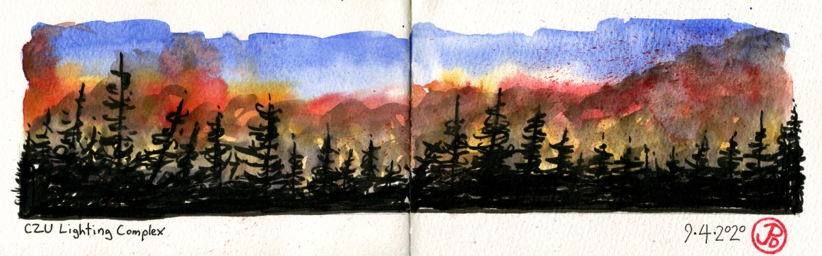
The whole storm lasted for about 30 to 45 minutes. At that time, little did I know, that this storm sparked wildfires that would create more damage in Santa Cruz County than the 1989 Loma Prieta Earthquake.
I finally drifted off to sleep and when I awoke and looked out across the deck to clear blue skies, I knew the day was going to be warm, extremely warm.
That day I chose to drive over Highway 9 through the San Lorenzo Valley. I rarely drove this route but I had many memories of the area including the town of Boulder Creek, where I worked at a coffee shop just after college. This highway would be a fire line in upcoming weeks. Over 900 structures would be destroyed to the west of Highway 9.
Monday August 17, was the first day of school and it proved to be one of the oddest first days in my teaching career because I was not greeting my students at the classroom doorway but online in my digital “classroom”. Well that was the plan until I got to school and found out that the power was out and PG&E later looked at a power pole on campus that had been struck by lighting (part of the same storm system that started the fire in the Santa Cruz Mountains) and destroyed a transformer. Power would not be restored until two days.
As the news came that a series of forest fires (a complex) was growing into one big wildfire, I kept an eye on Cal Fire’s updates on the contagion. At the same time trying to be present for my students who were no doubt anxious and nervous with the first week’s jitters, especially so because we where all in isolation and we where only seeing a facsimile of ourselves on a screen.
I was also planning for a digital Back to School Night on Thursday and I knew there would be many questions about Distance Learning and I surly did not have all the answers. I ended the presentation by sharing the poem I had written last April about how we were all like pioneers on the Oregon Trail. There would be many hardships but with perseverance and hard work, we would get there.
Back to School Night went better than I had expected and it was very odd not to see my parents and greet then in person. Half and hour later, at 7 PM I received work that a mandatory evacuation order was in place for Paradise Park and my family cabin was in danger of being consumed by the CZU Lighting Complex fire!
At the time of writing the fire that was named the CZU Lighting Complex had burned for 19 days and have consumed over 86,000 acres across San Mateo and Santa Cruz Counties. As of the morning of September 5, the fire is 61% contained.
Cal Fire were able to create fire lines to protect the UC Santa Cruz campus, Santa Cruz, Scott’s Valley, and Paradise Park. The evacuation order was lifted after seven days and residents were able to return to their homes. I headed back to my cabin, a week later, almost 20 days since I had left.
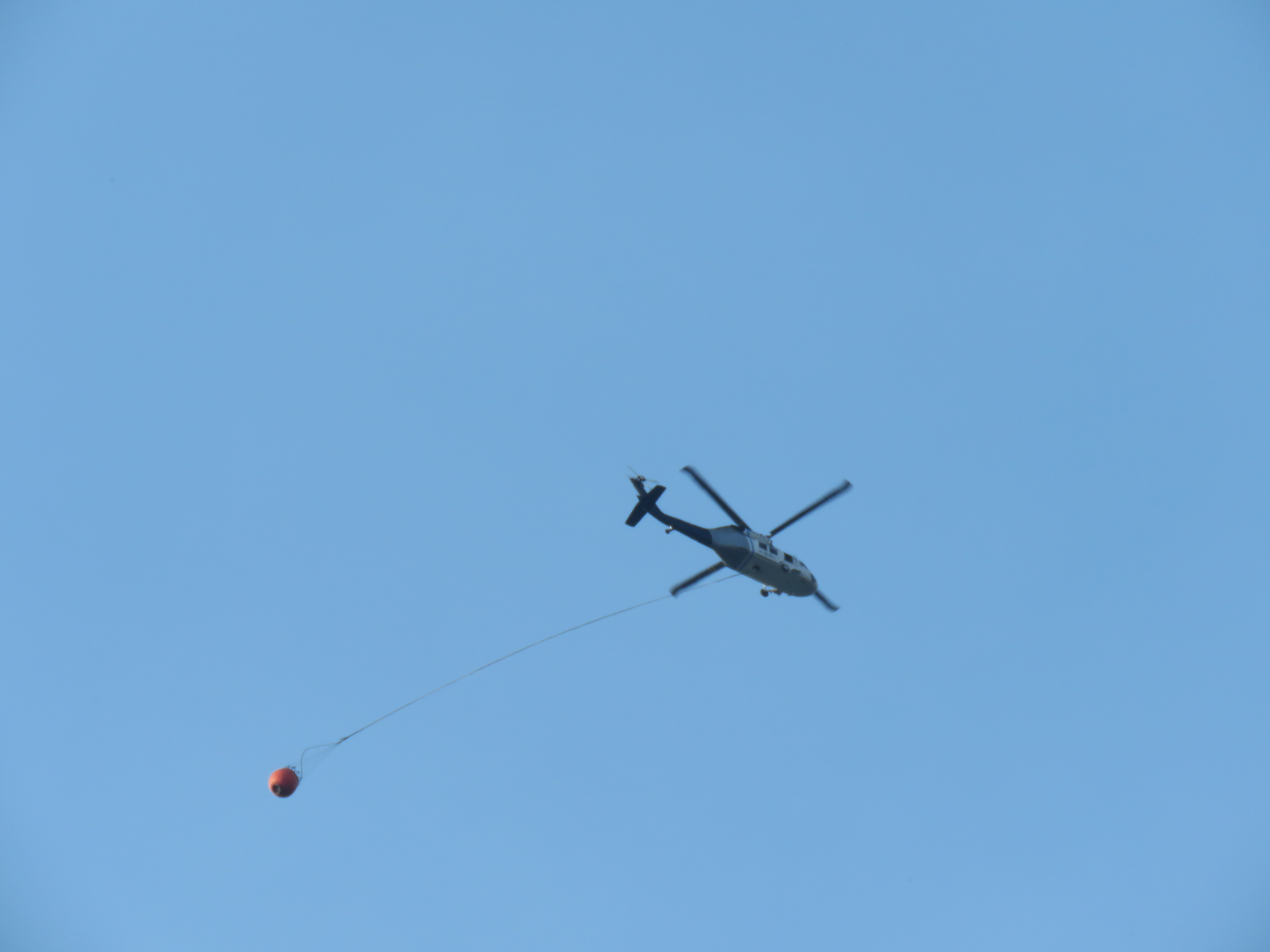
The first thing I noticed was the smoky air and when I looked down the ground was covered in fine white ash, like a light dusting of snow that hadn’t melted away yet. Then I headed to my deck and I heard the rumble of a Cal Fire Huey helicopter with an empty water bucket trading behind.
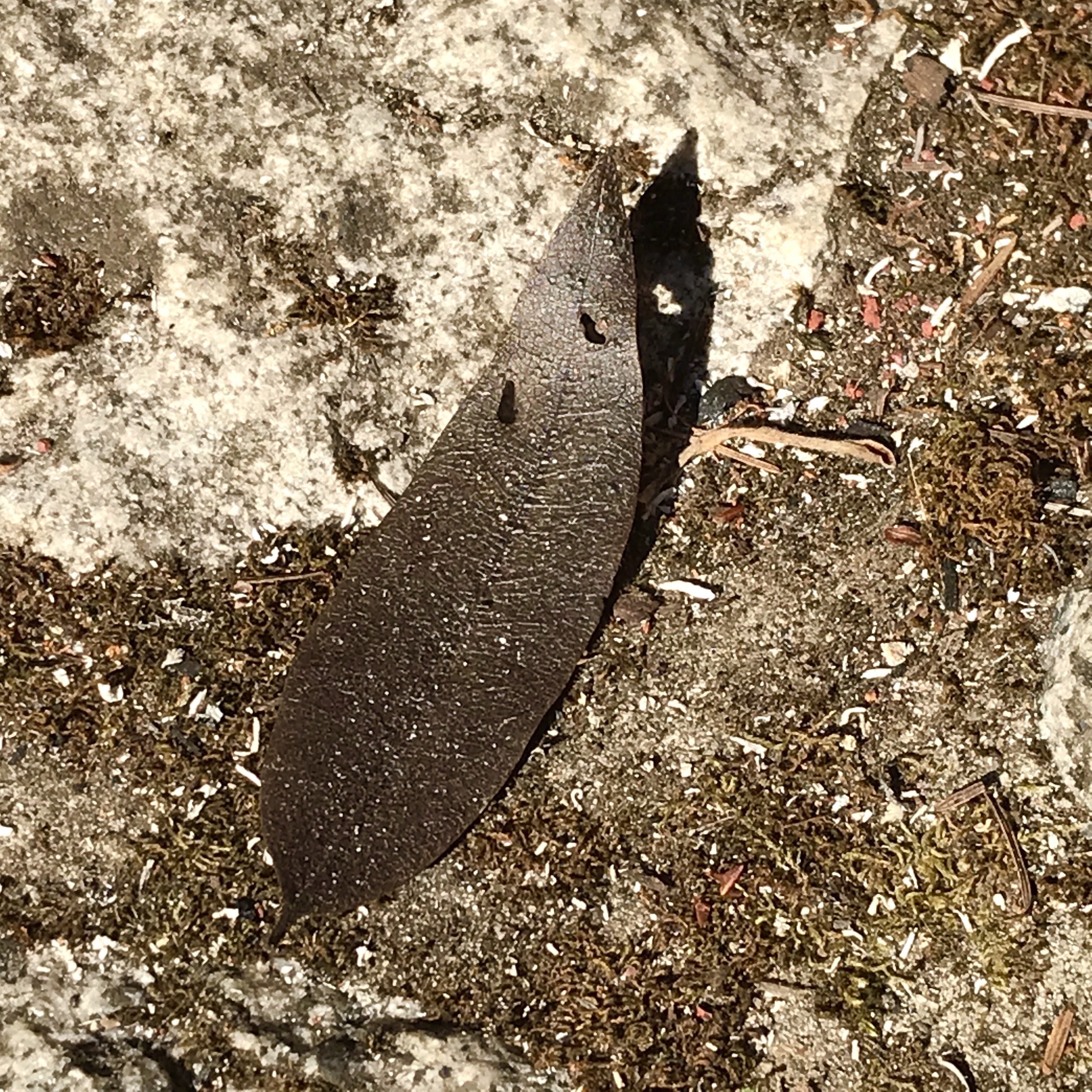
I looked down and that’s when I noticed the leaves. They were bay laurel leave but they were drained of color and were a charred sepia. How far from the fire storm had these leaves travelled to land on my deck? This evidence of fire was somehow more “real” than the smoky air or the Cal Fire helicopters passing back and forth.
A burnt bay laurel leaf on my front steps.
The suet feeding on the deck was empty and the trees around the cabin were eerily empty of birds. I wondered some animals, like the humans of the community, had fled to less smokey quarters.
I replenished the water in the bird bath and I added some suet to the feeder. Slowly, life was returning. The first bird to visit the feeder was a chestnut-backed chickadee. Life was beginning to return to “normal”.
Once, perhaps 35 years ago, I saw an American dipper (Cinclus mexicanus) flying downstream on the San Lorenzo River, between Middle and Sandy Beach in Paradise Park. What an amazing sighting. The bird of John Muir, the aquatic songbird of clear, turbulent mountain streams was on the San Lorenzo!
At the time I did not keep records so I don’t know the month or year of the sighting but since that time I have been looking to find another dipper on the river. This bird is an indicator species for the health of a river. Dippers are considered a rare bird in Santa Cruz County but there was suitable habitat upriver in Henry Cowell State Park that look promising. Large granite boulders, turbulent river water. This is where a dipper should be, I reckoned.
I first checked the location of my first sighting on the San Lorenzo on the turbulent turn in the river between Sandy and Middle Beach. This rocky bend looked like good habitat for dipper and I walked up river, checking river rocks for the tell tale signs of whitewash, bird poop. There was some but this could be from a black phoebe. I did not see a dipper here.
On another day I next searched Rincon Gorge upstream from Paradise Park. Dipper had been reported here in May 1988 and again in May 2009 where a nest with young was seen. That was a long time ago and there were no current reports on eBird. So I searched and I again dipped on dipper.
Now it was time for a bigger expedition on the San Lorenzo, to explore some of the best stretches of river between Coon Gulch and Garden of Eden Beach in Henry Cowell State Park. This effort would require traversing down to the river from the railroad tracks on what only could be called a mountain goat path and then hiking up and often in, the San Lorenzo, towards Garden of Eden.
I parked on Highway 9 and headed down the Ox Fire Road towards the railroad and Garden of Eden. When I was halfway down the trail I heard the primeval calls of our largest woodpecker: the pileated. On a Douglas-fir snag, about 100 yards from the railroad, I spotted a family group of four pileated woodpeckers! Either this was a good omen for my dipper search or a great consolation for dipping.
After leaving the pileated family I headed downstream on the railroad and took the trail down to the popular beach, Garden of Eden. Perhaps this beach should be renamed Garden of Trash. I was appalled at the amount of cans and bottles, random clothes and towels, and toilet paper. Beachgoers clearly ignored the “Pack Out Your Trash” signs.
The amount of discarded cans and bottles along the banks of the San Lorenzo was truly disgusting!
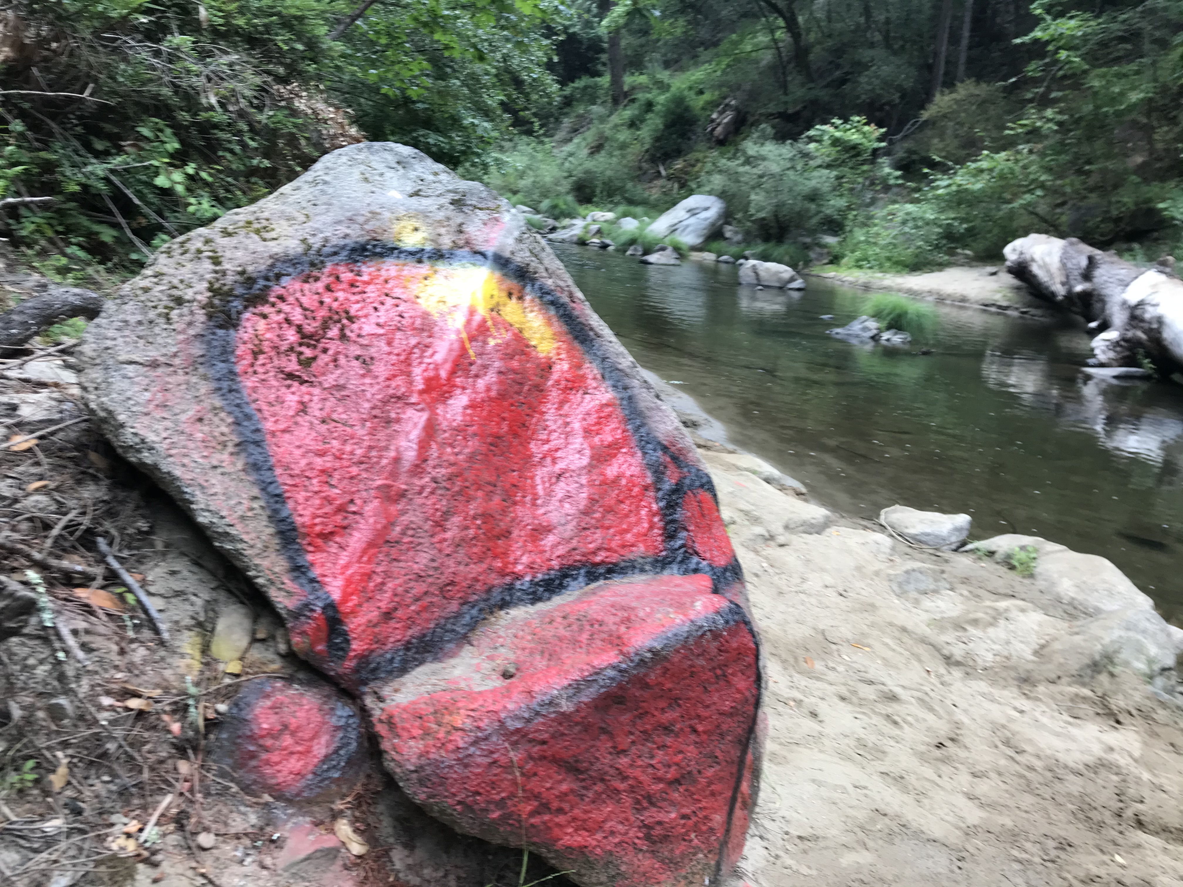
I headed upstream from Garden of Eden to check the granite boulders for dipper. I was further appalled at all the graffiti on rocks and logs. It seemed far from the favored pristine rivers that the dipper preferred. And I did not find any dippers upstream from Garden of Eden.
What makes someone come to the San Lorenzo and spray paint a rock, I will never know! No wonder I didn’t find dipper on this stretch of the river.
When I returned to the main beach a young man was wiping graffitti off a sign post that no longer contained a sign. I’m sure the sign said, “Don’t Litter” or “Respect The Trees, Dippers, and Rocks!” or “Save the Painting For Sketchbooks and Canvas!” Turns out he was an interpretive ranger from Henry Cowell State Park who comes to Garden of Eden, before his shift, to clean up the beach. I asked about beach clean-ups and he told me that when litter is removed, there is more to replace it on the following days. Shameful!!
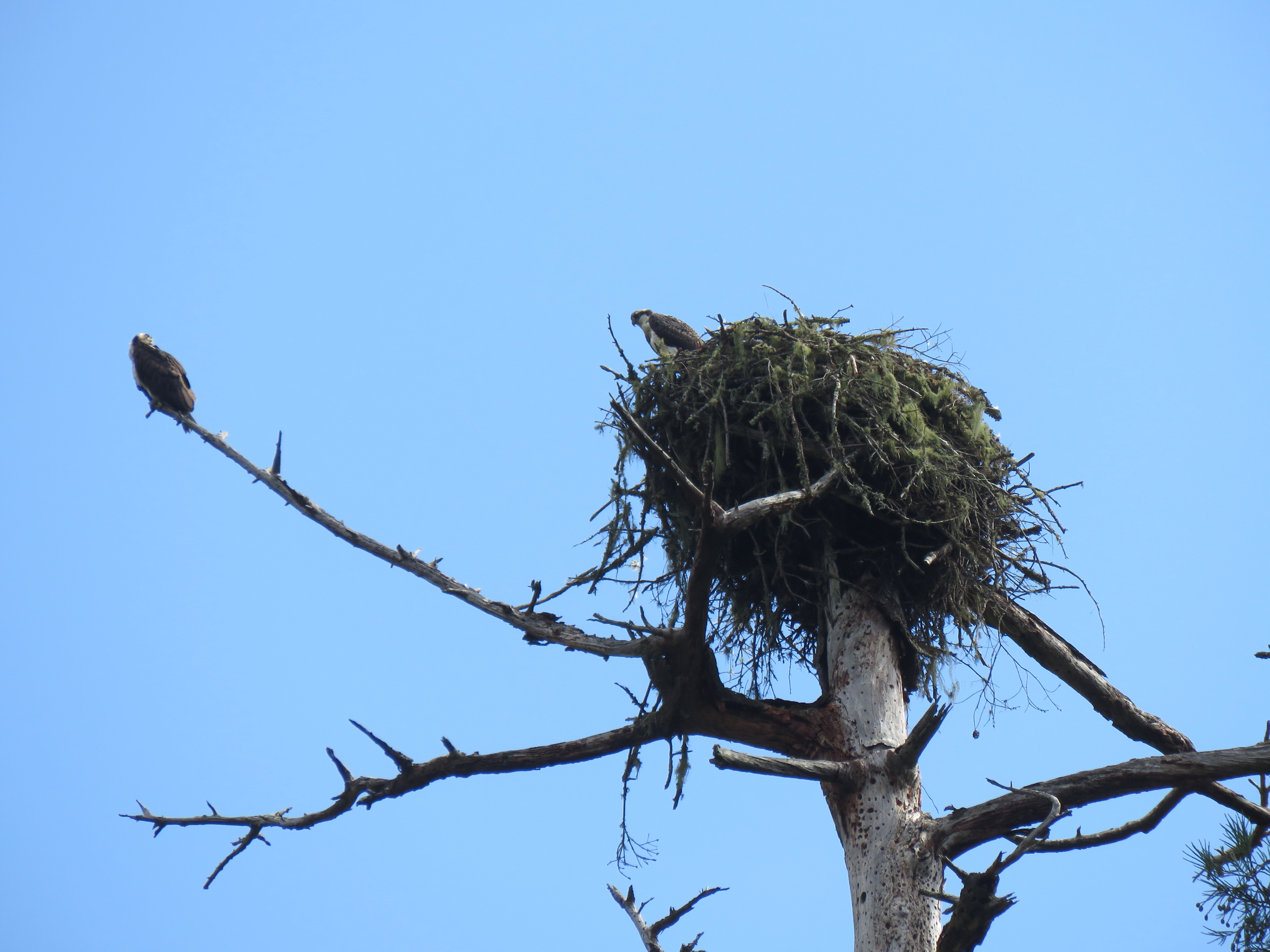
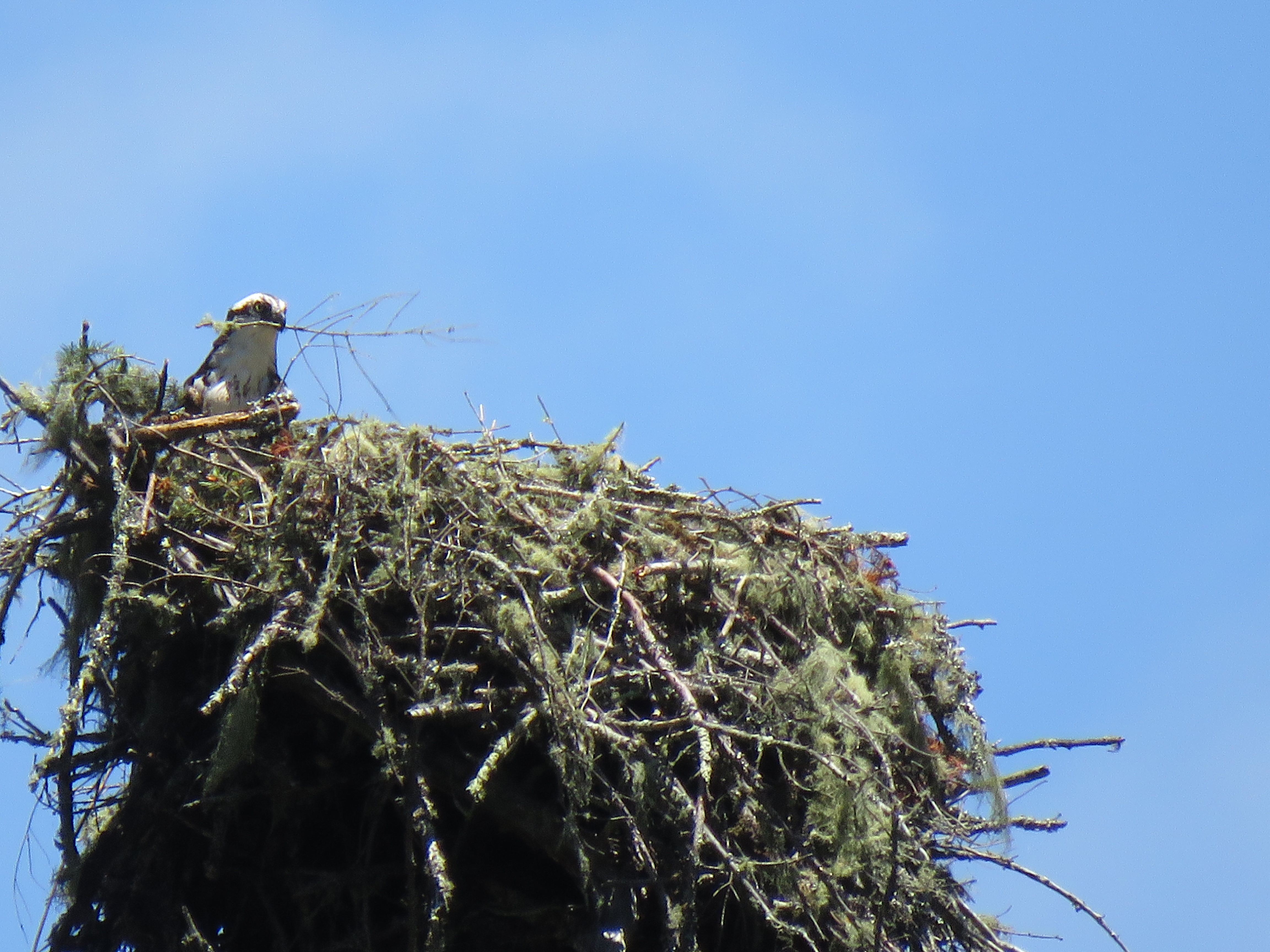
I returned to the railroad and hiked downstream towards Coon Gulch. I paused at the osprey nest where both adults were perched near the nest, indicating that there might be chicks hidden in the deep nest.
A view of the osprey nest and the two adults from below on the banks of the San Lorenzo. I did a brush-pen sketch of the nest on my journal.
I then headed down the steep mountain goat trail towards the river (this seemed so much easier 30 years ago). The final pitches of the trail had rope tried to trees to aid in the descent. This was a far less accessible part of the river and is not visited as much and seemed a little more “pristine” then upriver.
I traded my hiking boots for river sandals, made sure everything was secure in my dry bag, and I grabbed a hiking stick and headed upstream.
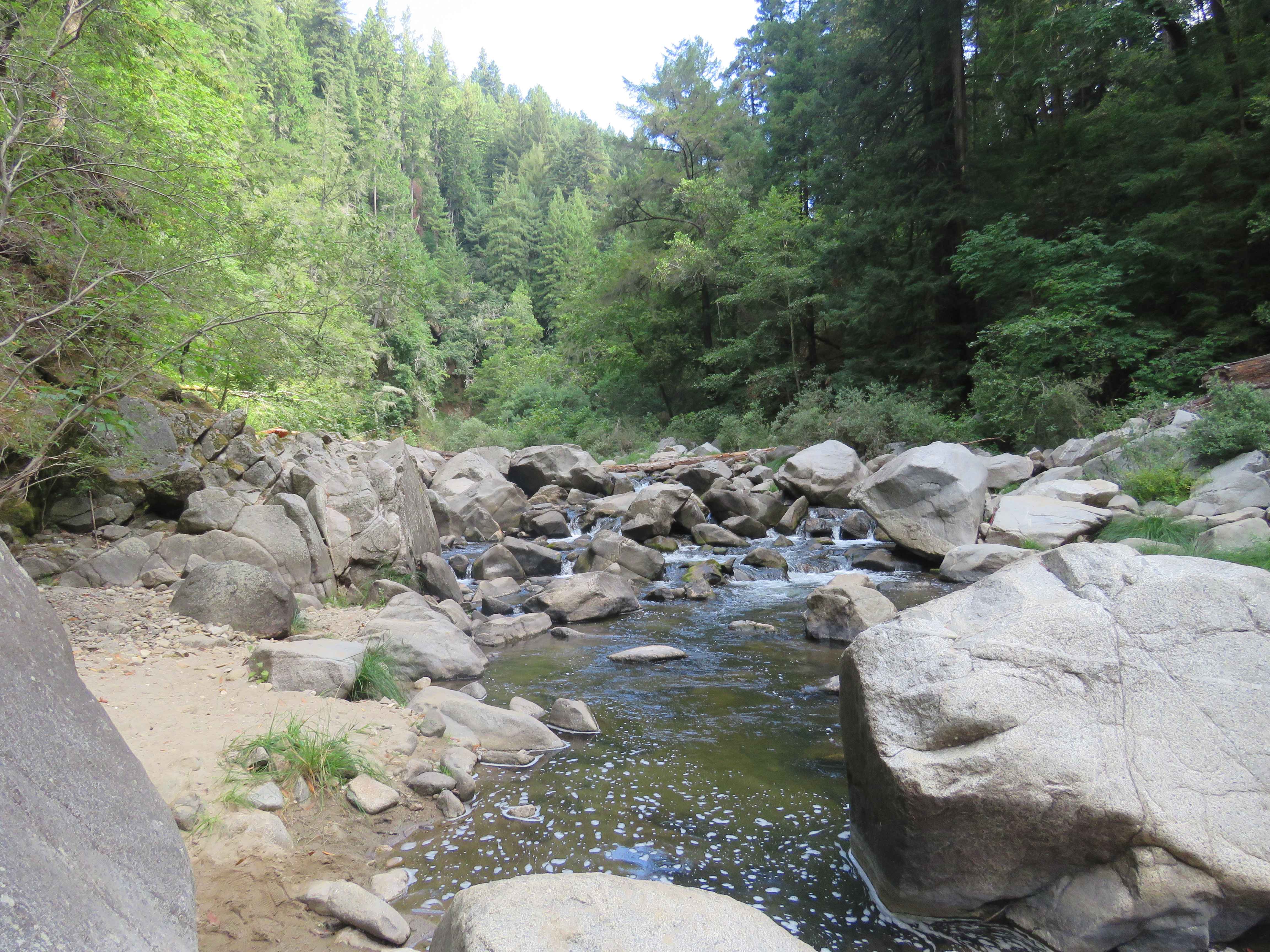
This, to me, is the most scenic and “wild” stretch of the river. The stream bed was lined in large granite boulders, perfect foraging perches for the American dipper.
Heading upstream on a beautiful stretch of the river, between Coon Gulch and Garden of Eden. If there was any place on the San Lorenzo that contained dipper, I reckoned this was it.
Progress was slow going as I was hiking in the river, reminiscent of The Narrows in Zion National Park. I had to pick my path through the large boulders often crossing and recrossing the river bed to find the path of least resistance. A bonus was finding a Pacific wren nest built under a fallen Doulas-fir tree that spanned the river.
The river veered to the right and I was in the stretch of river that when viewed from Highway 9 is known as Inspiration Point. I needed some avian inspiration at this point!
The river hike was an adventure in itself but the closer I came to Garden of Eden, I knew the the chances of seeing American dipper on this stretch was diminished. The habitat seemed right but the pollution and semi-turbid waters of the San Lorenzo did not look like the pristine mountain stream that the dipper require.
I have made the journey with no mishaps or injury and as I came in sight of Garden of Eden, which was now full of family groups, I took this time to slip and fall. It’s always good to have an audience. And as Nelson Mandela said, “The greatest glory in living lies not in never falling, but in rising every time we fall.” And so I recovered and stood up again only to see that no one noticed.
On a foggy morning, most mornings are foggy in the summer, I headed northbound on Highway 1. My destination was just out of the city limits of Santa Cruz, Wilder Ranch State Park.
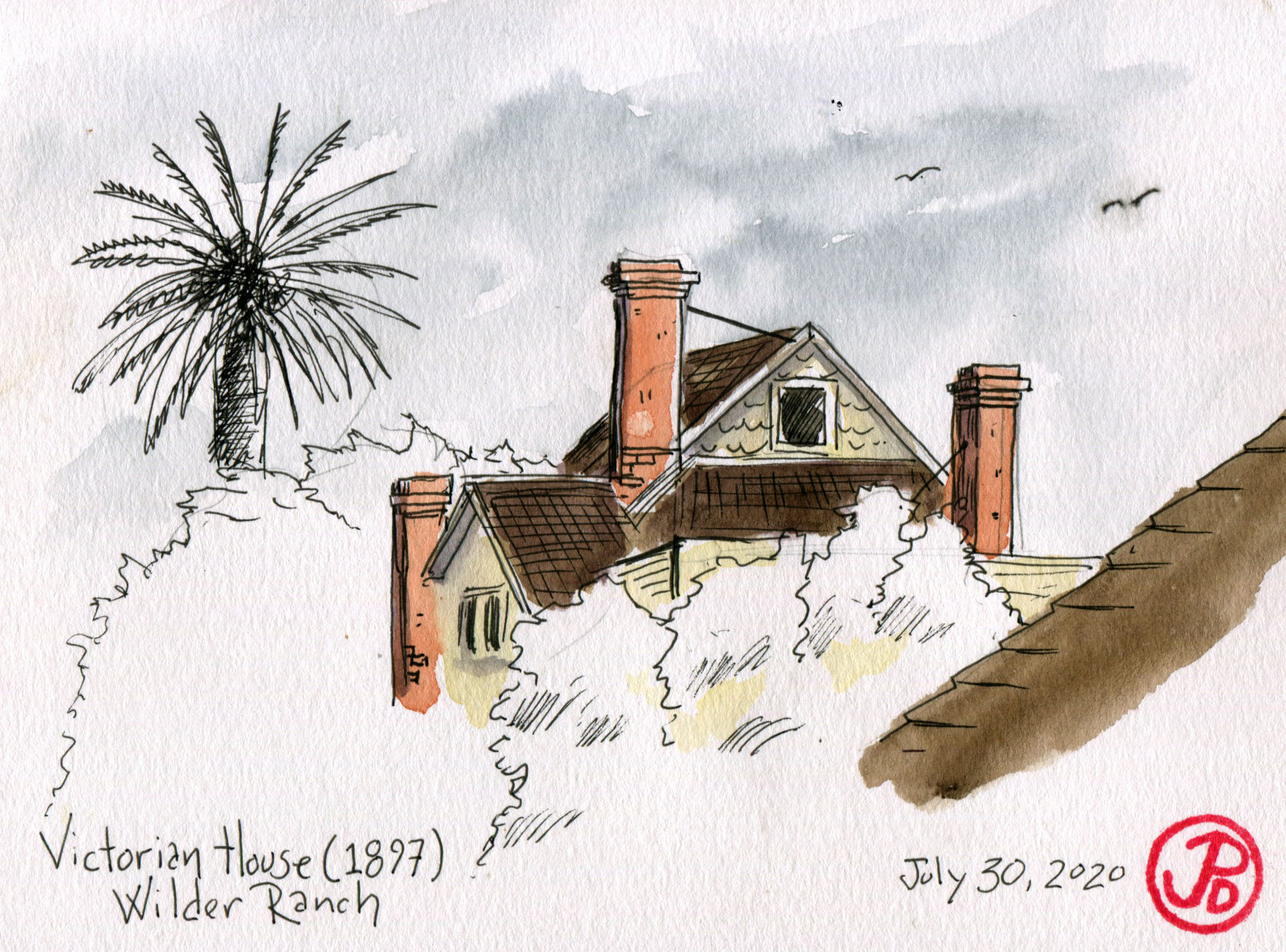
Wilder Ranch is a former dairy ranch on the coast. In 1871, two partners Baldwin and Deloss D. Wilder bought 4,160 acres of the a former rancho. In 1885 the partners split the acres in half and for the the next century the Wilder family farmed the land and their farm was prosperous enough to build a new Victorian farm house in 1897. The Wilder family farmed until 1969 when the farm became unprofitable.
The property became part of the State Park system in 1974. The park today includes 7,000 acres and is visited by hikers, mountain bikers, and birders. And a few sketchers too.
The closer I got to the coast, the thicker the fog. Fog and watercolor don’t always go together.
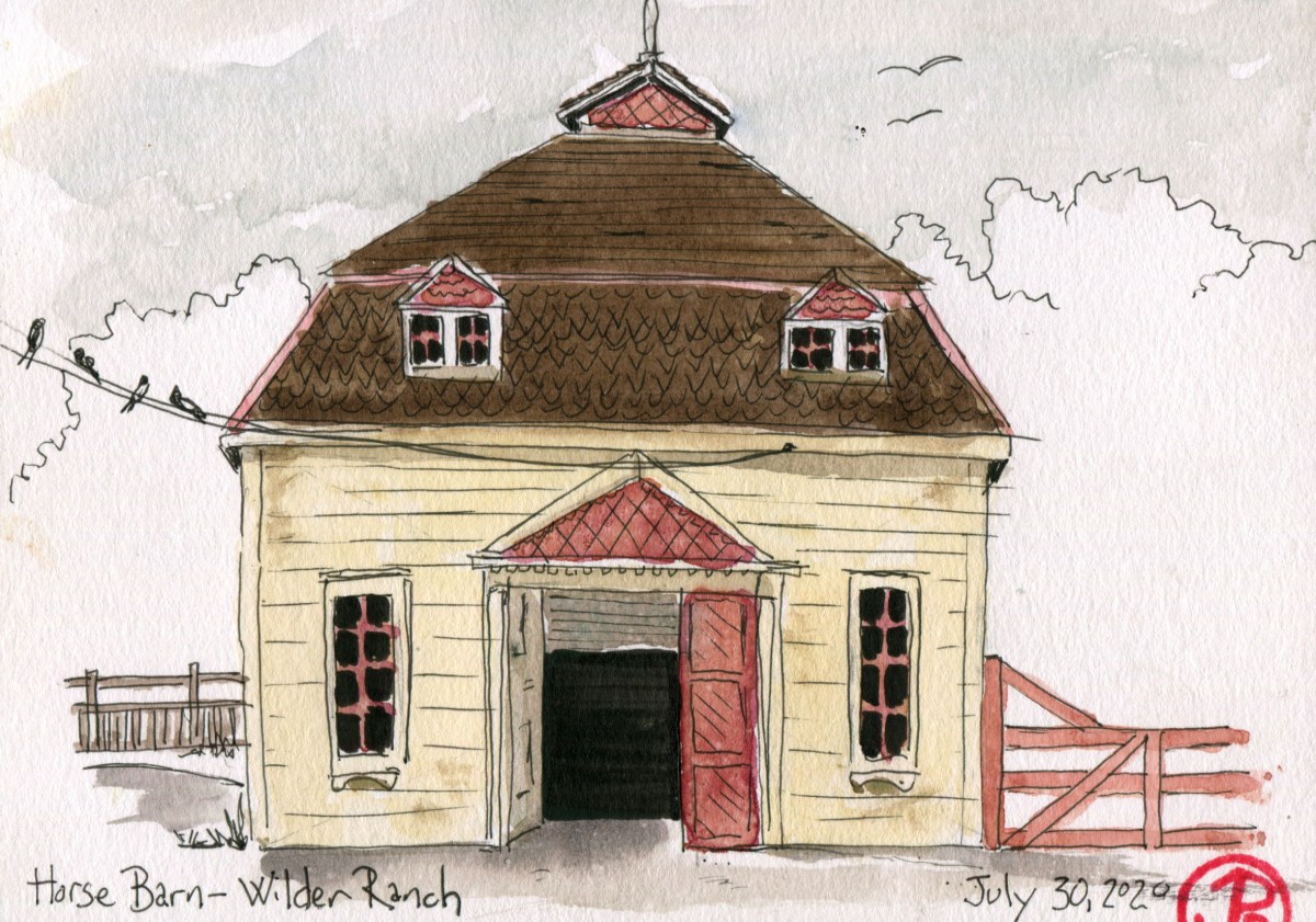
I parked on Highway One and headed down to the historic ranch buildings of Wilder Ranch. While most people hike or mountain bike on the 35 miles of trails of Wilder, I set up my camp chair in front of the Horse Barn.
This is a rather fancy barn, looking almost more like a house than a barn. Today this barn no longer houses horses but the interior provides a substrate for a bird’s nest, the appropriately named barn swallow. This year’s swallow fledglings where perched on the wires and buildings of the farmstead. I made sure to sketch a few in on the wires before they flew off on newly fledged wings.
After I finished sketching the horse barn, I walked a few hundred yards to get a vantage point of the Victorian farm house with the palm tree in the background. For this sketch I keep things a little loose, urban sketching style. For example I kept the sketch of the vegetation loose, and focused on the details and perspective of the house. I carried this over to the watercolor, I only painted the farmhouse and the roof in the foreground.
On my way out, I did a quick sketch of the scarecrow. The scarecrow was wearing proper face protection and was social distancing. There was not another scarecrow in sight! Nor a crow for that matter.
I wanted to add a new birdy feature to my cabin so headed to the local hardware and garden stores for a birdbath.
Some stores were out of stock while other had baths that were of the cutesy type with frog or bird figurines on the rim. These baths were about three feet of the ground. There was one bath that caught my attention, it was shaped like a whale’s tail rising out of the ground but the high price tag had me moving on.
I finally went to the local big box hardware store thinking they would have a large selection of birdbaths; they did not.
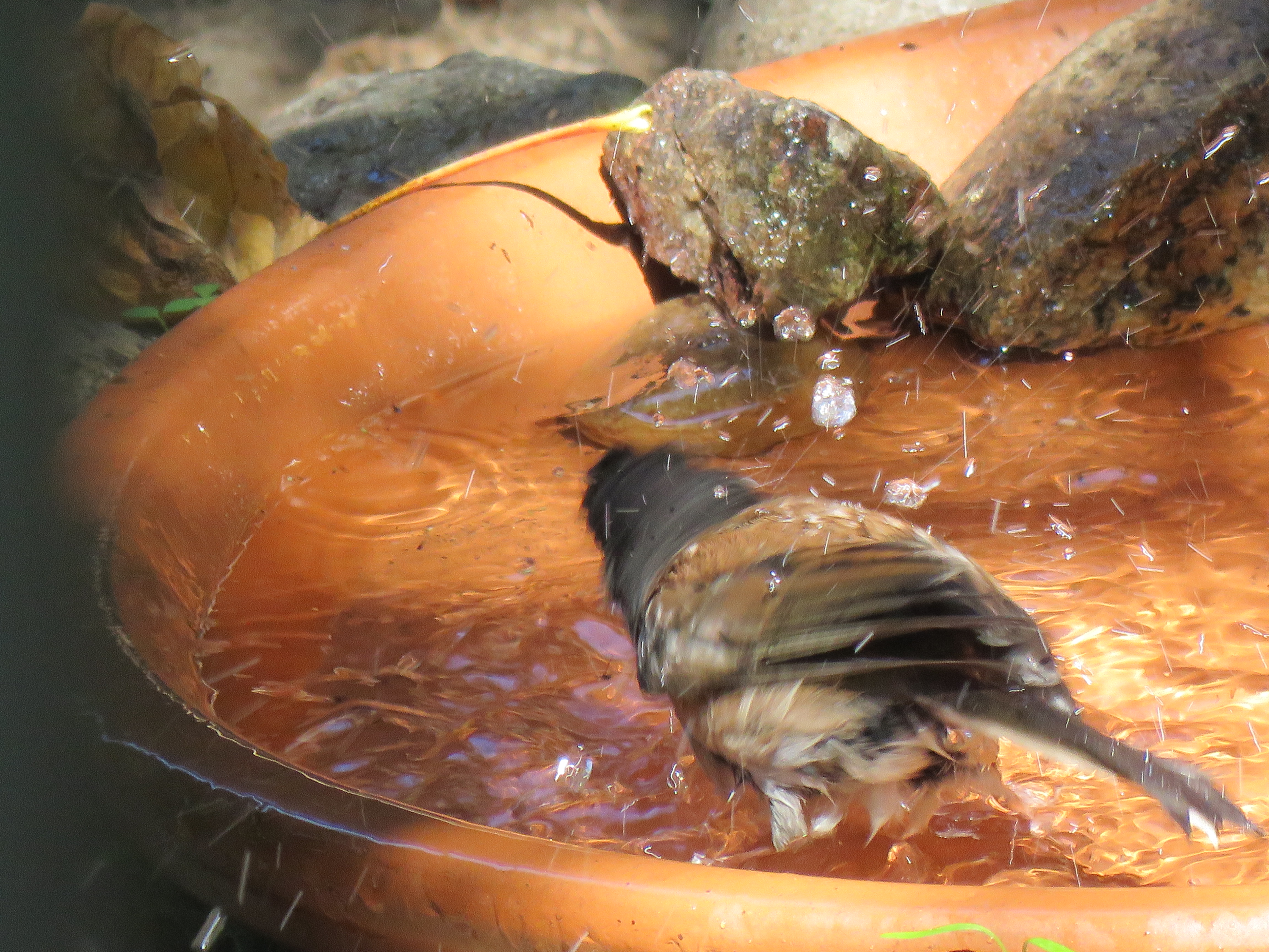
Now it was time for Plan B: which was to repurpose something in the garden section that was not designed as a birdbath. I was drawn to a large 16 inch terra cotta saucer. The type of saucer that you would rest a large pot on. This seemed to me to make a perfect birdbath that could be placed in the ground.
I placed the saucer in the middle of the freshly weeded dirt patch between my cabin and my neighbors. I leveled the ground with a spade and set the bath so it was slightly unleveled, so there was a “kiddie” end and a deep end. In the deep end I placed four small rocks, I was thinking of them as the ladder at the deep end. I then stabilized the bird bath with larger stones and rocks.
Now it was time to fill it with water and wait for the first bathers. I figured it would take a good two week before the local birds became used to the new water feature in their environment.
A song sparrow was the first bird I saw using the birdbath. Not to bathe but to drink.
I was away in Tahoe for a week and when I returned my neighbor reported that she had not seen any birds in bath but noted feathers in the bath and most of the water was gone. That was certainly promising news!
The first bird I saw using the bird bath was not a bather but a drinker. It was one of the local song sparrows coming in for a sip on a warm summer afternoon!
The first bather I saw came a few days later. It was a dark-eyed junco. There is nothing more enjoyable than watching a bird bathe, propelling water droplets in all directions.
A dark-eyed junco taking an afternoon bath!
I noted that the species that used the bath to bathe or as a drinking fountain were song sparrow, dark-eyed junco, and California towhee. These were bird species that spend time on or near the ground. I wondered if the bath was too low to the ground to be used by species that foraged further up in the trees, such as Steller’s jay, chestnut-backed chickadee, and pygmy nuthatch. It will be interesting to see if there birds could be lured down for a bath, especially on a warm summer’s afternoon.
A few days later I saw a California towhee taking a bath. It gives me such joy, in a joyless time, to see nature using something I’ve made. It’s just a small gesture to help species get along in life.
One of my neighbors knew I was struck with the affliction of birding and told me about the osprey’s nest on top of a Douglas-fir along the railroad about a 30 minute hike up river from my cabin.
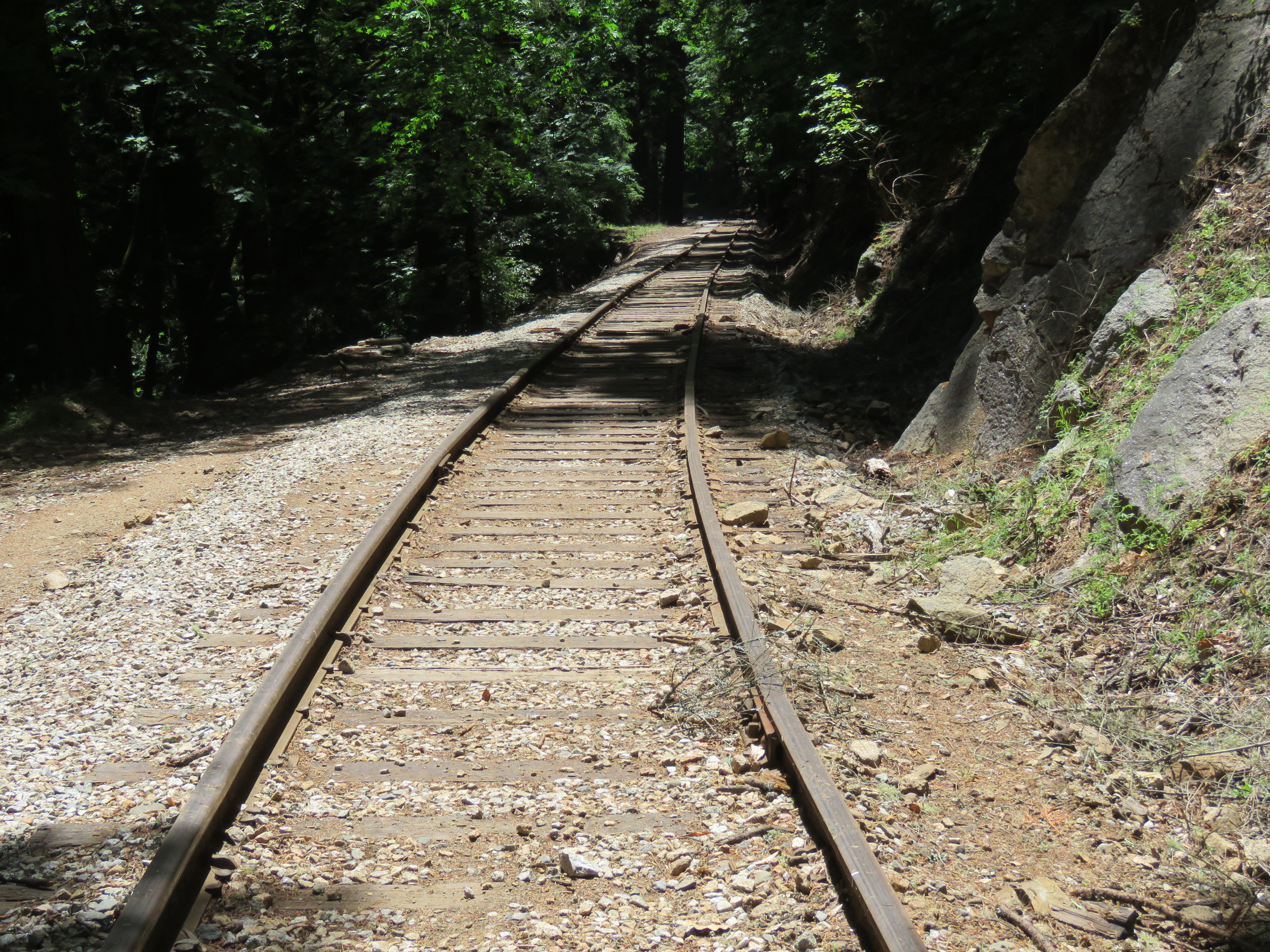
After work on Friday, I hiked out of Paradise Park via the fire road and scrambled up a deer trail to the even grade of the railroad. This railroad is now operated by the Santa Cruz, Big Trees and Pacific Railway and takes tourists from Felton to Santa Cruz Beach Boardwalk. At one time the railroad went over the Santa Cruz Mountains to Los Gatos but now does not go very far beyond Felton. I have hiked this railroad since my youth and it had been a few years since I played hopscotch on railway ties up the San Lorenzo Valley.
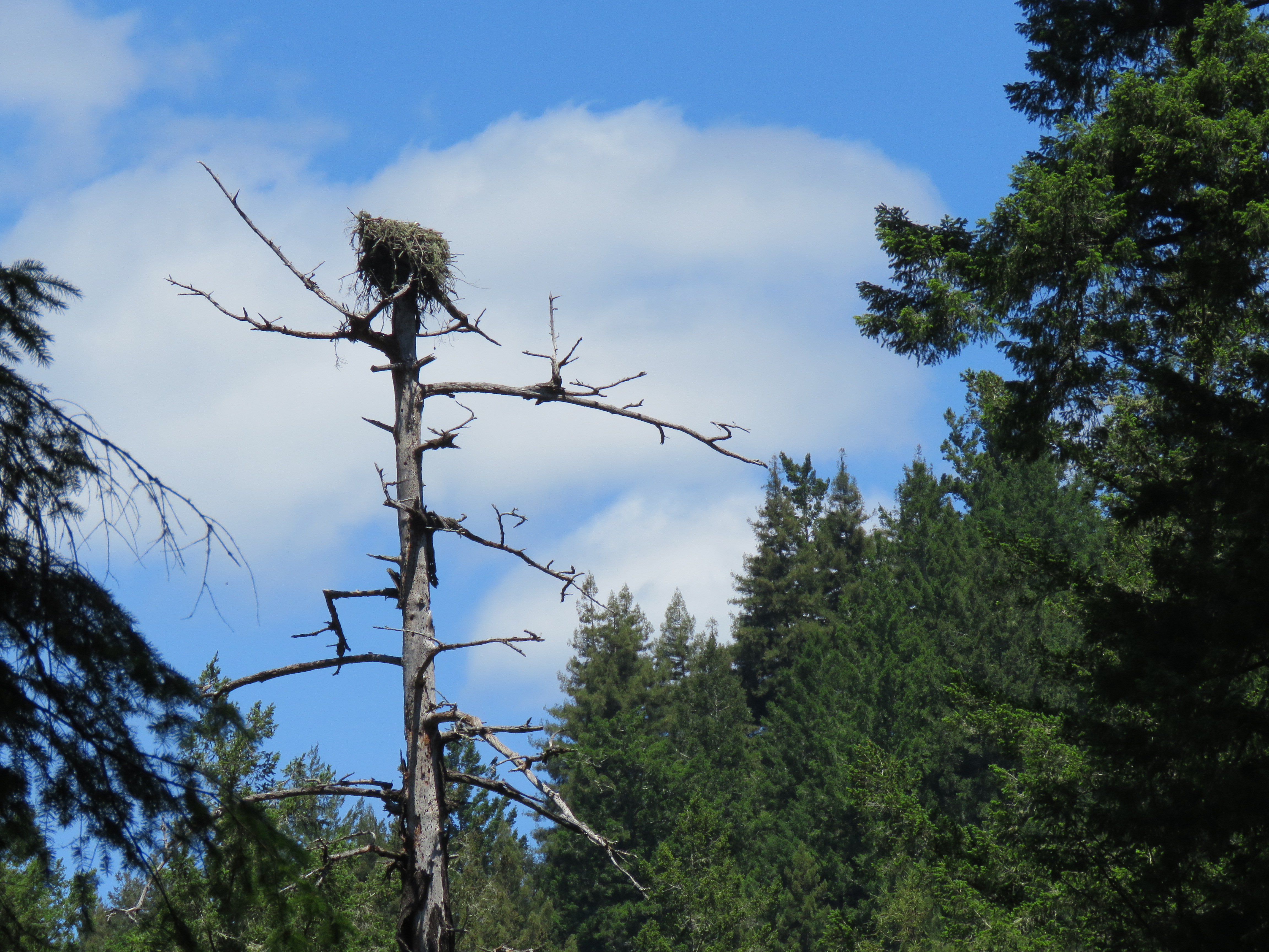
Walking along this rustic railroad always feels like I’m participating in a scene from Stand By Me on a quest to find a dead body. But in this case I was in search of a big bunch of sticks on top of a fir, high above the San Lorenzo River.
I kept one eye on the rails and one on the trees off to my right. My neighbor had given me good directions to the nest and when I was 30 minutes out of Paradise, I thought that maybe I had passed the nest. But how could I miss it? So I continued hiking upstream.
Ten minutes later the osprey nest appeared across the river between a break in the redwoods and firs. I put bins on the nest and could not detect any occupants. But osprey nests are deep and the osprey could be laying low. The only sign of life were the acorn woodpeckers that looked to have used the fir as their granary tree, their acorn larder, for years.
I was at a point in the line where the railroad curves gracefully over a curved viaduct. The concrete arched bridge was build by the Southern Pacific Railroad in March of 1905 and spans Coon Gulch. At this point the San Lorenzo River takes a turn and you can get an amazing view upstream. This point in the line is known as Inspiration Point.
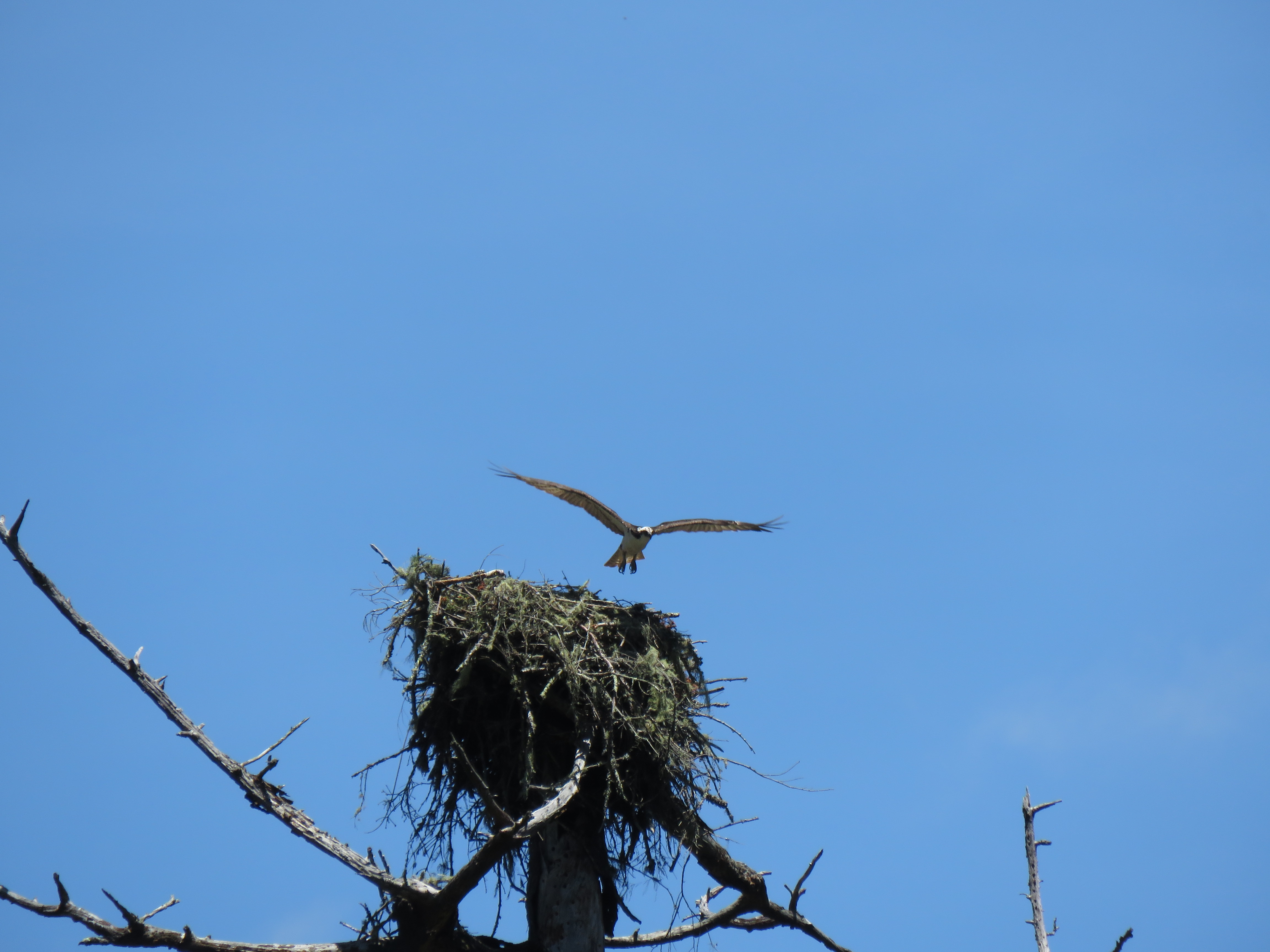
It didn’t take long to see signs of life. An osprey flew in and briefly alighted on the nest. Bingo! The nest is occupied after all. The unseen osprey, presumedly sitting on eggs, sat up in the nest and became visable.
The osprey that flew in could have been the male who is responsible for bringing fish to the nest while the female does most of the incubating of the two to three eggs. The male perched near the nest on a Doug-fir and preened.
First sign of life at the osprey’s nest. Perhaps the male dropping off fish.
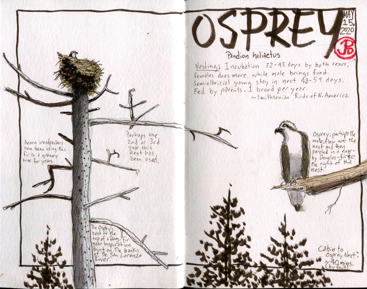
I stood by the railside and sketched the nest. On the left side of the spread is my field sketch (first in pencil then in dark sepia pen) of the Douglas-fir crowned by the osprey nest. The osprey perched on the right was drawn from a field photo I took of the presumed male. The title and text were added back at the cabin. In the end, I decided to create a spread that is almost monochromatic. I resisted the urge to paint in the sky because I didn’t want anything to distract from the form of the Doug-fir and nest.
The osprey doing a little housekeeping at the nest. This is presumedly the female who does most of the incubation of the eggs. Both sexes build the nest. A hiker who stopped to look at the nest told me that the nest had been there for past two or three years.Ospreys reuse their nests each breeding season. A lot of work has gone into this nest over the past two or three seasons.
“The redwoods, once seen, leave a mark or create a vision that stays with you always. No one has ever successfully painted or photographed a redwood tree. The feeling they produce is not transferable. From them comes silence and awe. It’s not only their unbelievable stature, nor the color which seems to shift and vary under your eyes, no, they are not like any trees we know, they are ambassadors from another time.” – John Steinbeck, Travels With Charley
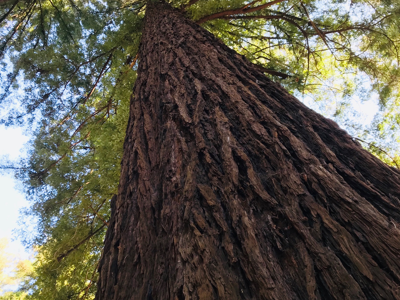
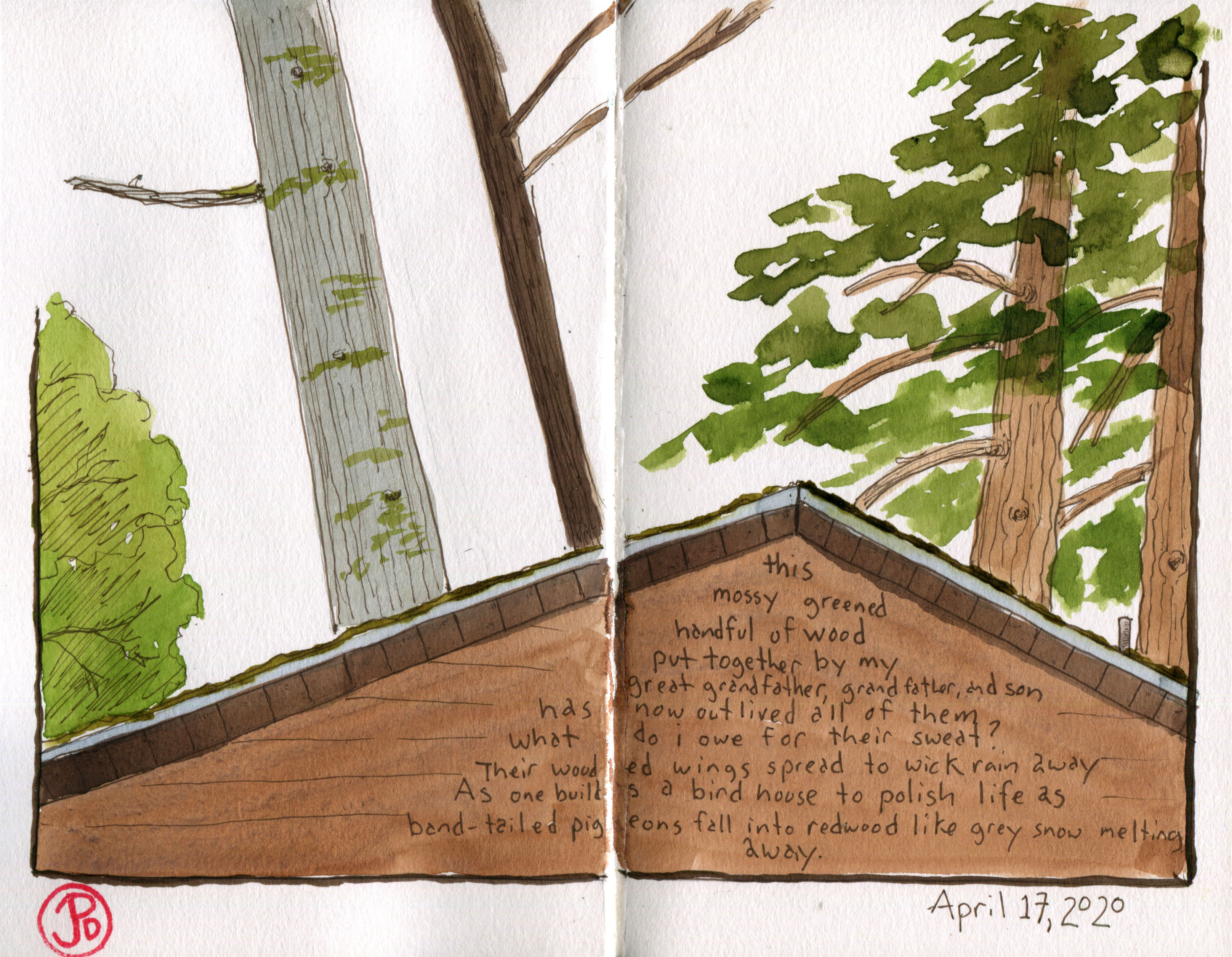
Over the past 15 years I have spent much time sketching around my cabin in the Santa Cruz Mountains among the redwoods, douglas-firs, big leaf maples, and bay laurels. I have sketched all of the trees but one of these stands above the others. That would be Sequoia sempervirens, the coast redwood.
I have always loved sketching coast redwoods and I have sketched them many times and I understand their visual language. For one, they are not too hard to sketch, a straight trunk that reaches up to the sky like a giant sundial. These trees are so massive that when I sketch them, I only seem to capture a small part of them as the tree grows off the page. As Steinbeck noted, “No one has ever successfully painted or photographed a redwood tree.” I agree with this because I have attempted both, with mixed results. And I love the idea that you can sketch or photograph a subject but never truly capture it’s essence.
The coast redwood is a California native, growing along the coast (as it’s name implies) with it’s northern range just crossing the border into Oregon. In every sense the coast redwood talked about in superlatives. They are considered the tallest trees on planet earth. The tallest specimen is 379 feet high. They are also long lived, living between 1,200 to 1,800 years old. They are also one of the oldest species on earth.
In Paradise Park, most of the redwoods and Douglas-firs are second growth and are not necessarily considered superlatives of their species. The giants of the species are usually found further north. Except for one exception.
This redwood is known as the “Founders Tree” and it is believed to be the largest and tallest tree in Paradise Park. It is 24 feet in circumference and about 200 feet tall. The tree is estimated to be about 350 years old. Just for context, this tree is older than the government of the United States of American by about 100 years.
Your neck gets sore looking up toward the top of the Founders Tree.
The stone marker notes that the the Founders Tree was dedicated on August 12, 1974 and celebrated the foundation of Paradise Park on August 12, 1924. It is certainly a paradise for me in these tough and uncertain times.
With the current pandemic and the shelter in place order, I chose to shelter in Paradise during my Spring Break. My family cabin is in Paradise Park, just up Highway 9 from downtown Santa Cruz.
Here I have more legroom than my digs in San Francisco and the population density here is far less than the 7 by 7 mile County and City of Saint Francis. Another factor was that San Francisco had almost 1,000 Covid-19 cases and the larger (by size) County of Santa Cruz had just 90 (at the time of writing). This seemed like a no brainer! Head to Santa Cruz for my two week Spring Break.
This move allows me to spread out, breath fresh air, and be amongst the redwoods and river. It also gives me a very familiar patch to sketch from. Here I know all the birdsongs and paths, all the secluded river beaches, and the places of solitude and rest. And I certainly needed both after three weeks of distant teaching.
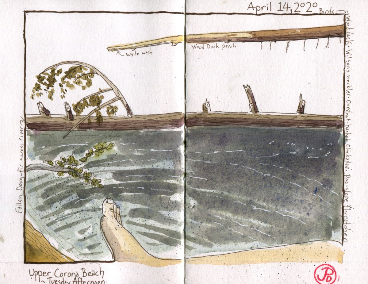
Some of my favorite sketching locations in the Park are my redwood deck and different locations on the San Lorenzo River, certainly the most important landform that runs through the Park. A beach that I have always loved both as a place of repose and sketching is what is known in my own person geography as Corona Beach (this was named long before the infamous virus).
To get to Corona Beach involves heading up stream with some bush whacking, fording the San Lorenzo (which was trying to take my feet from under me), and then a little more bush whacking to arrive at a small, sloped river beach. Today it was occupied by a young couple, so I headed up stream (social distancing, dontcha know) and arrived at Upper Corona Beach. A smaller bit of sand on the river side. This is clearly a feral beach, wild, rugged, and something Mary Oliver might write a poem about. Well Mary is no longer with us so I guess I will have to give it a go. . . . a poem hasen’t blessed my brain at the moment (the trouble with poetry) so I did a sketch instead (featured sketch).
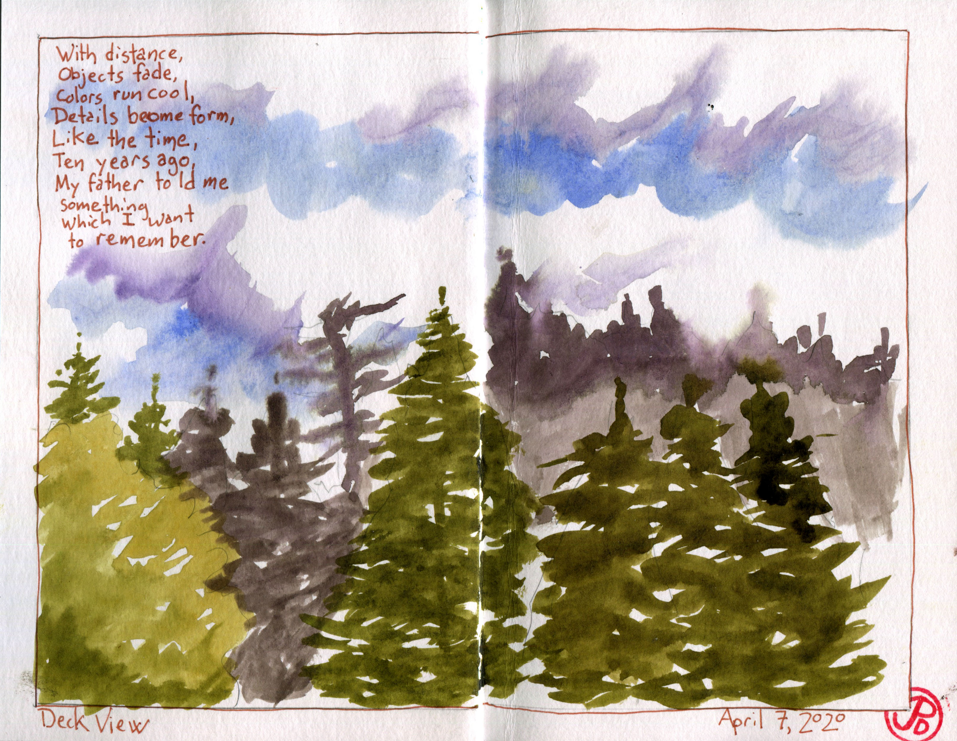
I also like to be in open air and sketch the green treescape of the view. This was a excise in creating depth in a sketch. In this desk sketch I included a poem:
With distance,
Objects fade,
Colors run cool,
Details become form,
Like the time,
ten years ago,
My father told me
something
Which I want
to remember.
With this deck sketch I tried to work with creating depth with warm and cool colors and tone. I also worked on my brush work to create the treescape.Roof view of my cabin surrounded by big-leaf maple, douglas-fir and redwood. The redwoods on right contains Bird Box #2 (the redwood on the left). More on the box in a later post.