Image

Sacred Sites the Union Pacific: Wyoming

On my journey from California to Colorado, I had a few historic sights I wanted to sketch along Highway 80 in Wyoming. This is Union Pacific territory, and the route over the Wasatch Mountains from Ogden Utah to Green River is legendary.

The Evanston Roundhouse and the Ames Monument are relics from a different time. The roundhouse was of a time when steam was the prime motive power of the Union Pacific and the monument the Ames brothers at Sherman Summit is no longer near the mainline (the line is now three miles to the south).

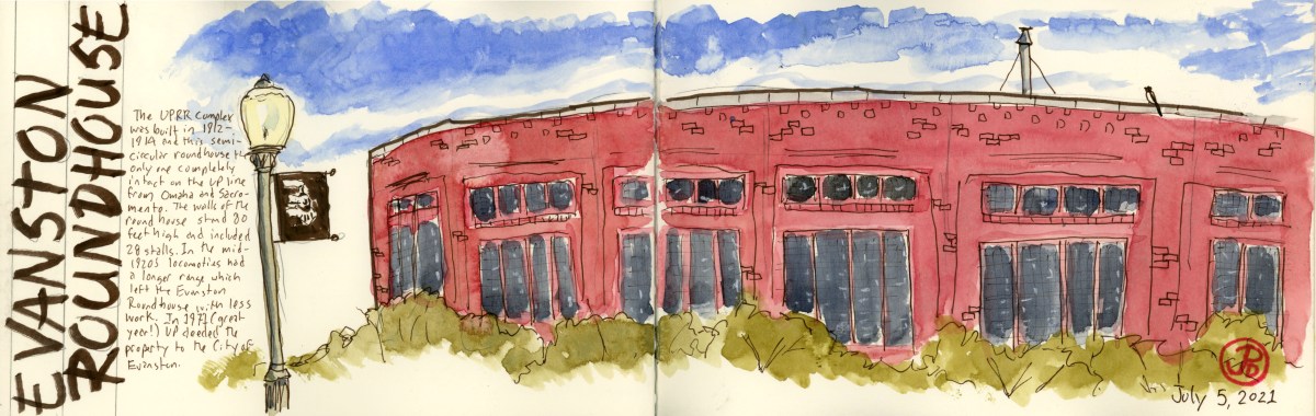
The Evanston Roundhouse is notable because it is the last completely intact roundhouse left on the Union Pacific line from Sacramento to Omaha. It had 28 stalls and is 80 feet high.

The roundhouse at Evanston on the left and the powerhouse on the right. The rusted, overgrown tracks in the foreground tells us that this complex has not been used by Union Pacific for a long time. I had to walk a ways back to photograph the whole massive roundhouse.

The roundhouse and yard was build by UP from 1912 to 1914. The roundhouse was part of a 27 acre complex to service steam locomotives. When steam locomotives became more efficient, they did not need to make so many service stops and the yard at Evanston was often bypassed. The Union Pacific deeded the property to the City of Evanston. The roundhouse is now used as a conference center and a meeting place.

Standing before the red brick semicircular roundhouse reminded me of a Plaza de Toros in Spain. Looking at just one part of the structure gives no indication of it’s form. I sketched one side of the roundhouse with the roofline slowing curving around (featured sketch). To see the entirety of the roundhouse, one has to walk back from the roundhouse by at least 100 yards to take it all in.

An intermodal freight passing through Evanston. The two locomotives on point represent the Transcontinental Railroad. The Union Pacific is pointed east towards Cheyenne and behind # 8990 is a former Southern Pacific locomotive (representing the Central Pacific) facing west toward Sacramento.

The next Union Pacific site is to be found off Highway 80 near the town of Buford (population 1). This is a monument to two brothers who were essential in creating the Union Pacific side of the Transcontinental Railroad.

The Ames Monument was built by the Union Pacific and dedicated to the brothers Oakes and Oliver Ames. It marked the highest point on the original Transcontinental Railroad at Sherman Summit at 8,247 feet. Oliver was one of the first presidents of the Union Pacific Railroad (from 1866-1871) and his brother Oakes was a U.S. Representative from Massachusetts. Both brothers, at the request of Lincoln, were put in charge of financing and building the Union Pacific portion of the railroad. Without the contribution of the Ames brothers, the railroad might never have been completed.

The 60 foot pyramid was build in 1880-1882 of granite at the cost of $64,000. On two side are base-relief portraits of each brother. In 1901, Union Pacific rerouted the mainline a few miles to the south.

On my first attempt to sketch the Ames Monument, a thunderstorm rolled in from the west. This monument being 60 feet high and at one of the highest points on the original Transcontinental Railroad, I though it would be wise to head to my car and return in the morning!
Image

Where’s the Moose?!

If there is an unofficial animal for Jackson Hole and Grand Teton National Park it would have America’s largest deer. The moose is featured in and on paintings, sculpture, bumper stickers, t-shirts, hats, postcards, etc. A moose rack hangs above the four famed Antler Arches in the Jackson Town Square, each painted with the words: “Jackson Hole, Wy”.

The Antler Arches of Jackson. A few words come to mind, “tacky” and “garish” are but two.

Now finding a moose should be as easy as throwing a snowball and hitting a millionaire in Jackson. I started my search turning left at Moose Junction and heading southwest on Moose-Wilson Road (no joke). I drove down and back, no moose! I searched the ponds and creeks in the area, ideal moose habitat, no moose! I checked all the moose hotspots in the park, no moose! I searched areas outside of the park like the Gros Ventre River, no moose (but I did see my first herd of bison). Who knew that finding the world’s largest deer would prove to be so tough? I returned to the Anvil Hotel, crestfallen, that I have not seen my first moose in one of the moosest National Parks in the world.

Not a moose but the first of many bison in Grand Teton and Yellowstone.

I lit out of Jackson early because there was a storm bearing snow, soon to arrive and I wanted to make all the passes in Yellowstone so I could make it to my digs in the town of West Yellowstone, Montana. I left at 8:00 AM and stopped to fuel up. I headed north toward Grand Teton and Yellowstone, past a picnic area and this is what I saw:

And just when I wasn’t searching for a moose, I found moose! A cow with her calf.

Image

Independence Rock, The End of My Trail

My final destination on the Oregon Trail, before I headed to Grand Teton and Yellowstone National Parks, was Independence Rock. This was another destination, like Chimney Rock, that I was really looked forward to seeing and sketching. It would be the end of the road for me on a journey that started at California Hill in Western Nebraska and passed through some of the most scenic and emblematic scenes on the Oregon and California Trail.

My base camp was Casper, Wyoming and Independence Rock was about an hour’s drive to the  southwest. I was really heading into sparsely populated country (Wyoming is the least populated state in the Union), where the highway, the North Platte River, the trees, and the snow-capped mountains were my traveling companions.

Independence Rock appeared as a large, low chunk of granite,  just left of the highway. And like the pioneers that passed this way, this was also a rest stop for modern travelers.

I walked around the rock until I found a place to climb up on the rock to find the real gold on this piece of granite. The reason that Independence Rock is such an important site for the present day is that it is known as Register of the Desert because emigrants that paused to rest here, ascended the rock, just like I was doing, and took the time to carve their names and date of passage into the granite. And what is most amazing, like the wagon ruts at California Hill, the signatures are still legible today!

 On my way to the summit I came across this name. Could this be a relative of mine?

A signature writing into the history books of Independence Rock: “I. J. Hughes July 4 1850”.

One of the thousands of names carved into the granite of Independence Rock. This one reads, “Milo J. Ayer, age 29. 1849.” It is amazing that this signature of a 49er still exists!

My last field sketch from the Oregon Trail before I headed back to Casper and then across the state of Wyoming to Grand Teton and Yellowstone National Parks.