Three million people visit Gettysburg National Military Park every year, making it one of the most visited battlefields in American History.
People come to this battlefield to look over the landscape, read the carved marble words on monuments, and photograph the bronze statues.
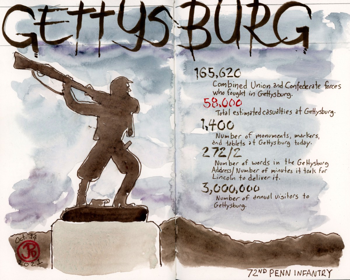
There are 1,400 monuments, statues, markers, and tablets spread across the roughly 25 acres of the former battlefield of Gettysburg. The battle was fought over three days on July 1, 2, and 3 of 1863 in, but mostly around the town of Gettysburg.
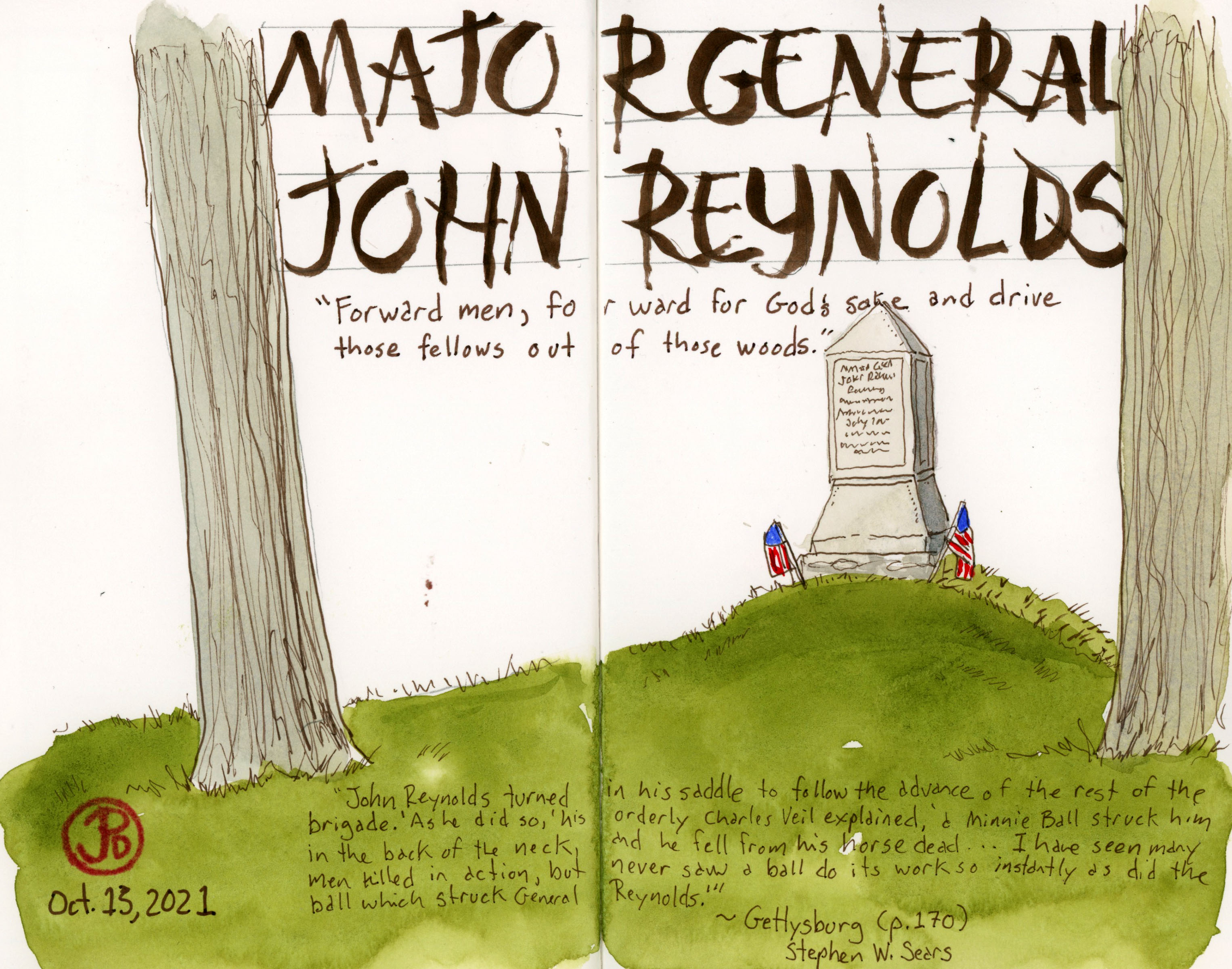
This is one of the many monuments on the Gettysburg Battlefield. This monument marks the spot where General John Reynolds was shot and killed on the morning of July 1, the first day of the battle. Reynolds was they highest ranking officer killed at Gettysburg.
So why did the Battle of Gettysburg happen at Gettysburg? General Lee moved the Army of Northern Virginia through Maryland and up into Pennsylvania in an attempt to cause a battle that would force Lincoln into peace talks. Looking at a map of Gettysburg, we see that all roads lead to this town, from all points on the compass. And there was plenty of coveted high ground to the north and south of Gettysburg.
All roads lead to Gettysburg.
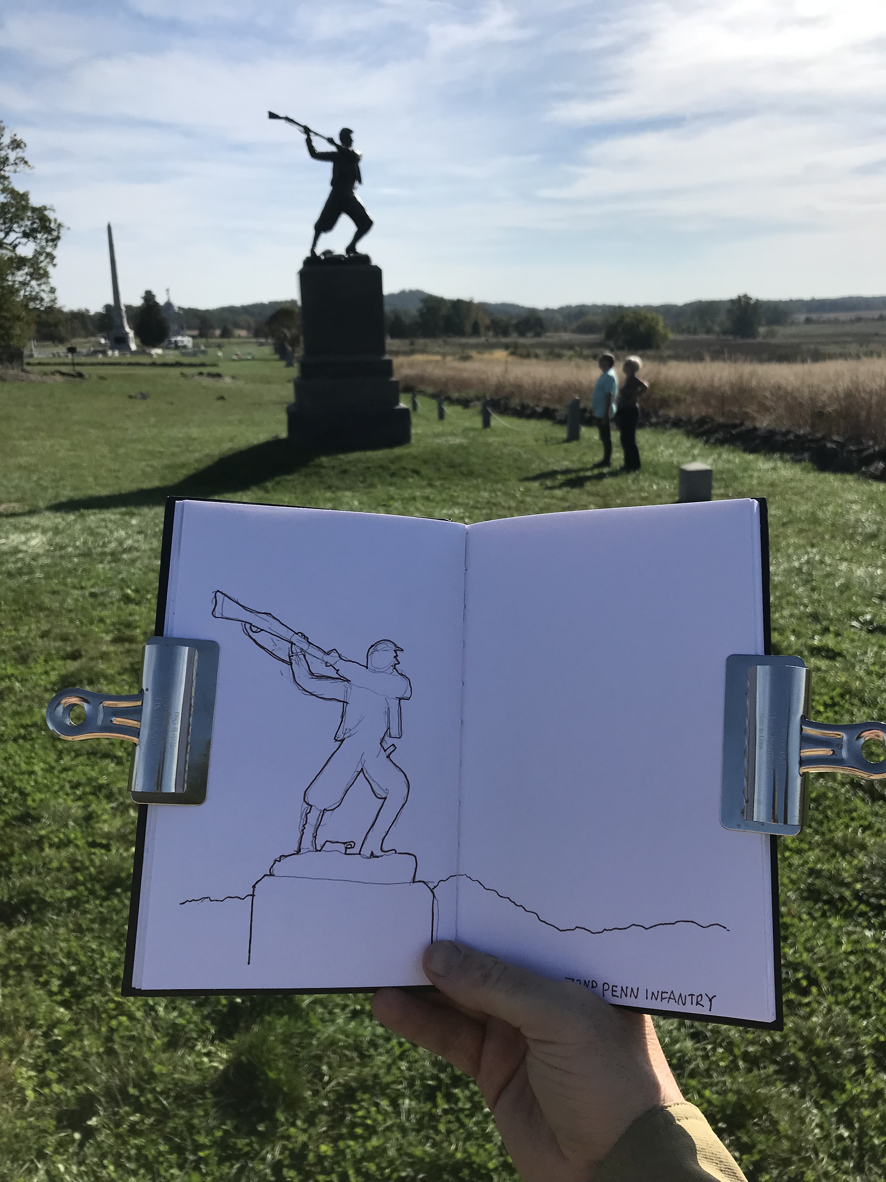
Over the next few posts I will share some of the many sketches I did at Gettysburg (summoning my inner Alfred Waud). I spend three days exploring the rich history of this battlefield and it provided many sketching opportunities.
Here I am field sketching the 72nd Pennsylvania Monument at the Highwater Mark, the climax of the Battle of Gettysburg as two people admire what is one of the most iconic statues on the battlefield.This is largest monument at Gettysburg and it’s fitting that it is the Pennsylvania Monument.
The Battle of Antietam, near Sharpsburg, Maryland, is the single bloodiest day in any American War battle. During the Civil War, every causality was an American so the causality rate is understandably higher than in other conflicts. But the brutality of the fight over once day, makes the Battle of Antietam stand out amongst other battles.
About 23,000 where killed in this once day conflict. The Battle of Antietam, named after the creek that flows east of Dunker Church, was a failed campaign, by General Robert E. Lee to invade the north in the border state of Maryland. It was also not the decisive battle that Lincoln wanted and the ever meek General McCellan, let the depleted rebel army escape across the Potomic. McCellan was soon replaced but this victory was enough for Lincoln to introduce the document that had been sitting in a desk drawer: the Emancipation Proclamation.
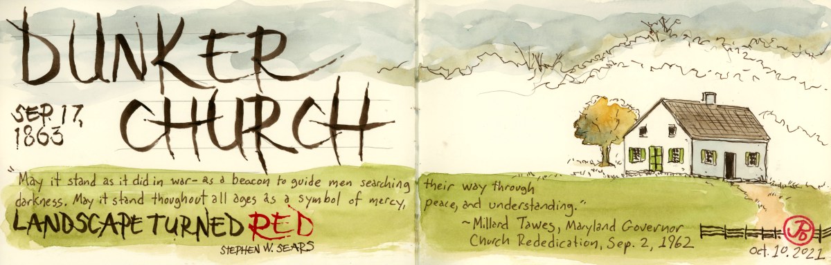
One of the enduring sights from Antietam is the Dunker Church. It has been called, “one of the most famous churches in American military history”. This simple, one room church was surrounded by the horrors of war on September 17, 1862. When soldiers first came upon this small, plain, and unassuming building, some thought it was a schoolhouse.
The church was granted on a parcel of land by farmer Samuel Mumma and was constructed in 1852. The “Dunkers” were a pacifist German Baptist congregation, which is very ironic considering the bloodshed that surrounded the church on a September day in 1862.
Antietam, the mix of the holy and the profane. Dunker Church and cannon.
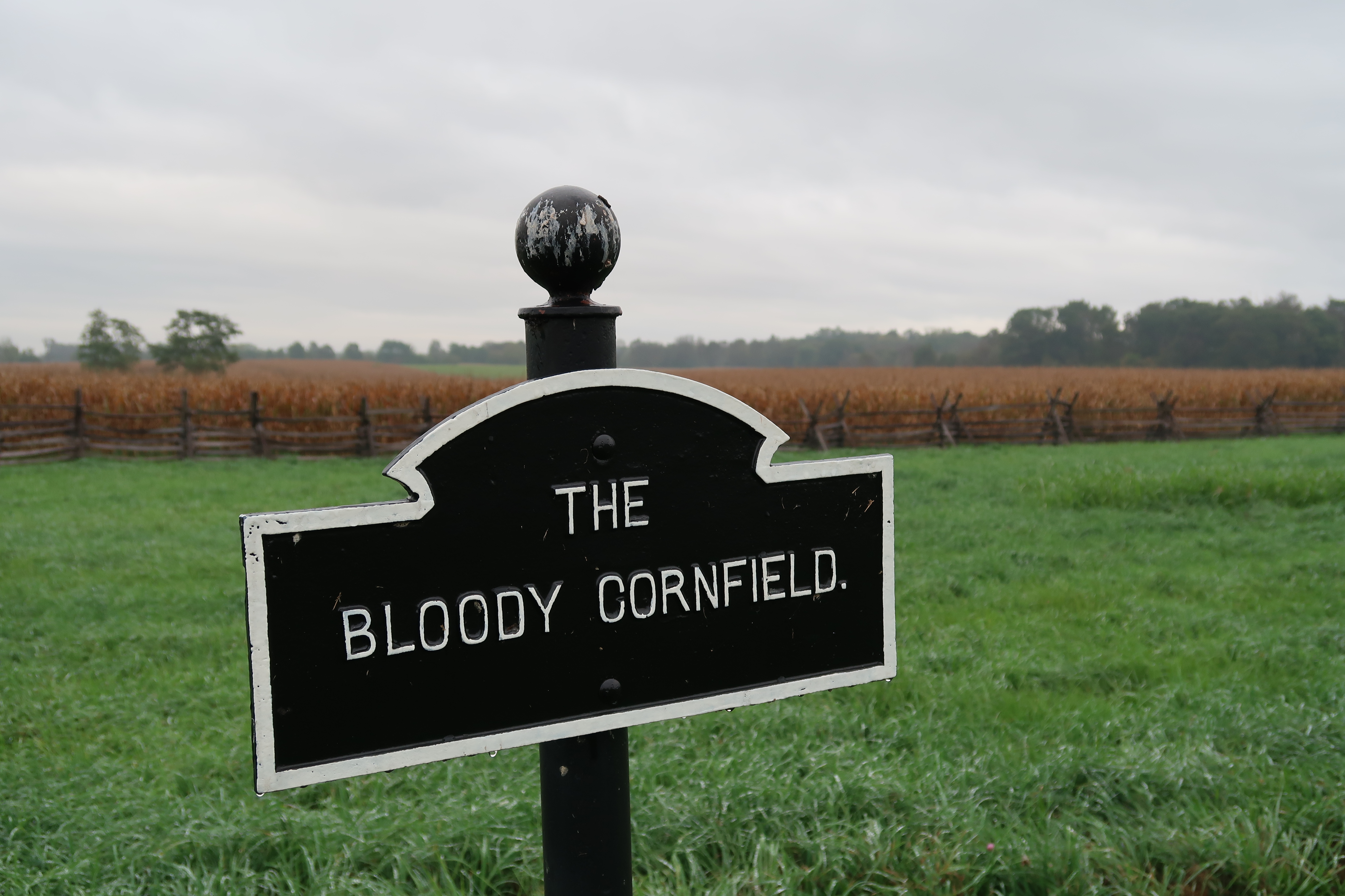
The battle started near the church on the morning of the 17th. Blood runs thought the landscape and place-names of this battlefield. To the northeast of the church was a cornfield, after the battle, it was given the infamous moniker, the Bloody Cornfield. Many men, both north and south, died in a field of life giving corn.
The Dunker Church was the center of the morning’s conflict and today, the visitors center is built near the church. When I visited, on an early October Sunday, there was an artillery demonstration in a field to the east of Dunker Church. So I stuck around because reenactors would be firing a replica Napoleon Cannon.
Civil War reenactments started in 1960, the centennial of the war. It has been a growing hobby, some might say “obsession”, since that time. One of the biggest Civil War reenactments was to celebrate the 135th Anniversary of the Battle of Gettysburg (much more on Gettysburg later). That event included 15,000 participants. It seemed that Civil War reenactments are on the wane these days and younger generations have differing views of the Civil War, its influence and it’s impact. As a result they are not taking up the replica muskets and joining a “battle”.
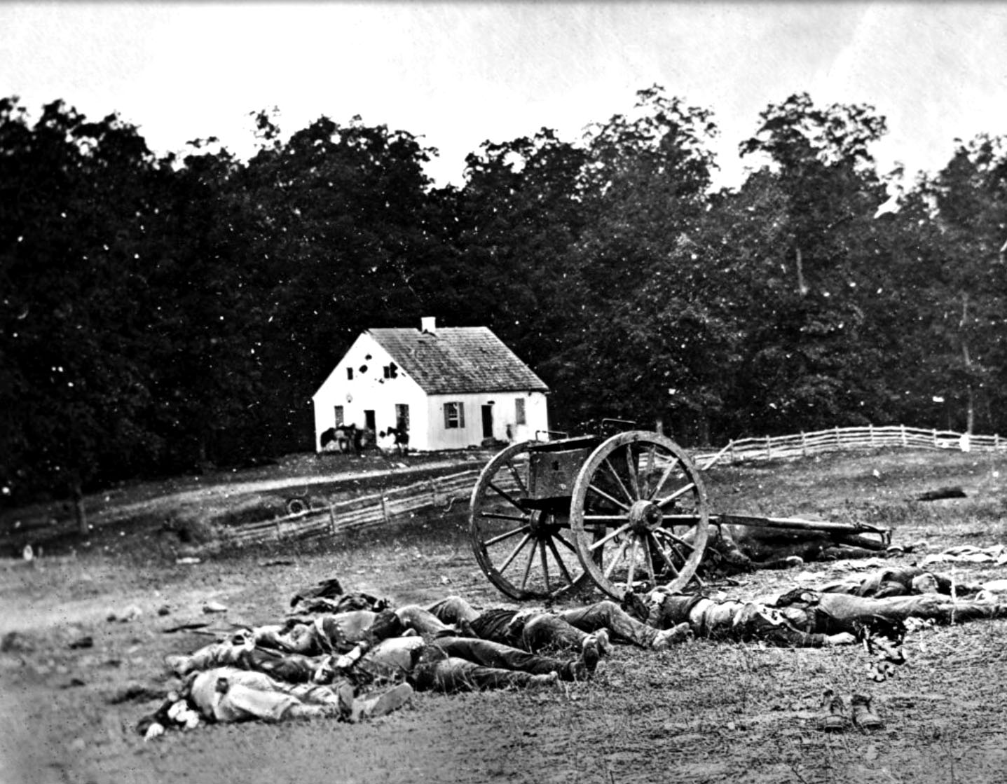
These reenactors where dressed in the mismatched uniforms of the Confederate Army. Maryland was a border state during the Civil War and Lee counted on support from the locals on his Maryland Campaign. In the end, this didn’t really happen.Fire In the Hole! The canon demonstration was both loud and powerful. It was haunting to hear the cannon echoing across the rural Maryland landscape. I’m not sure if the neighbors sleeping off Saturday’s revels felt the same.A photography taken just after the battle of Antietam showing Confederate dead in the foreground. In the background, Dunker Church shows damage from artillery fire. This is the photograph where I took inspiration for my featured field sketch.
To me, there is no better way to pass time in an airport than sketching.
I always have my small Stillman & Birn Delta Series in my pocket. The reason I enjoy using this 3.5″ X 5.5″ soft-cover sketchbook is that it allows me to do quick sketches. There is not so much paper to cover as a “standard” sized sketchbook. If sketching because more easy, you tend to do more of it.
I always try to take a seat, facing a window and sketch the planes on the tarmac as they are lined up like a school of sharks at their gates. I try to sketch the plane I will be departing on. But any plane will do.
I have included a few of my sketches in this post. They were done at SFO (San Francisco) and DCA (Reagan International).
During the battle of Antietam, the Sunken Road became the Bloody Lane.
In mid morning, the fighting moved away from the Dunker Church to the area to the southeast known as the Sunken Road. The Sunken Road is a road that bisects two farm fields and as the name implies, runs below the land that flanks it; like a riverbed without the water. This road was worn down over time because of heavy wagon traffic.
This location was the setting of some of the fiercest fighting in a battle known for it’s fierce fighting. This is where the center of the Army of Northern Virginia and the Army of the Potomac came together.
Here, in the Sunken Road, the Confederates under General D. H. Hill placed this division of 2,600 soldiers along this road. Union General William French attacked this position leading to a savagely bloody conflict that lasted for almost four hours. During this battle 5,500 soliders, on both sides, where either killer or wounded. Thus the Sunken Road became the Bloody Lane.
Soldiers who were involved in the conflict later describe the Sunken Road as the “road of death” and a “ghastly flooring”.
On my visit, I placed myself about half way down the Bloody Lane and I sketched looking toward the 132nd Pennsylvania Monument and the observation tower that was built in 1896 by the War Department. Starting out early had it’s benefits because I had the Bloody Lane to myself.
After my field sketch, I headed over to the 60 foot tall observation tower to get a 360 degree view of the battlefield and the receding view of the Bloody Lane. Again, the tower was all mine.
A photo taken from the observation tower, looking down the Bloody Lane. My sketching position was where the green turns to brown, just under an oak.
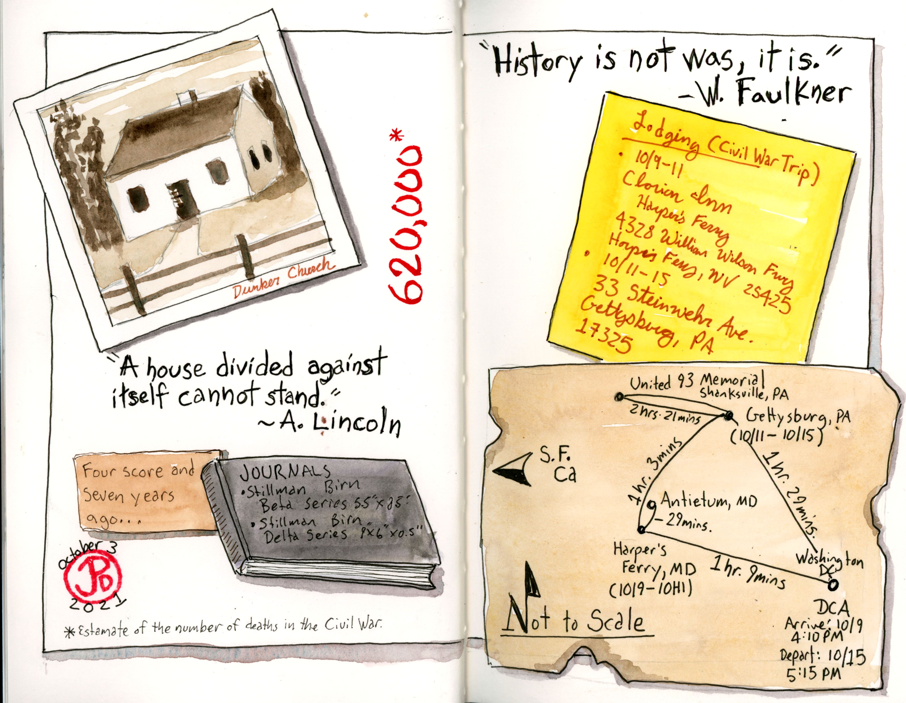
Before I go one any trip I like to add a title page and a map to my sketchbooks.
For my trip to Civi War battlefields in Virginia, West Virginia, Maryland, and Pennsylvania I chose to bring two Stillman and Birn hard cover watercolor journals. One is my new go-to favorite, the panoramic Delta Series journal. And the other is a Beta Series 5.5 ” X 8.5″ sketchbook. I love both of these papers and they are great for sketching on the road with pen and watercolor.
In the Delta journal I created the title page based on the famous image from Ken Burns’ documentary The Civil War, of a silhouetted canon and a glorious sunset in the background. This footage was filmed at Manassas in Virginia. This opening page is the featured sketch.
In my Beta sketchbooks I created a map of the places I would be visiting. All of the locations I would be visiting where within 90 minutes of each other. I distressed the map, covering it in mud and blood. Perhaps I added too much “blood”, but somehow since this is the Civil War it was fitting. It is estimated that about 620,000 Americans lost their lives during the Civil War.
In my Beta, created to spread to synthesize a lot of the information about my trip in a creative way. It is a montage of all the important facts of the trip. Well some of them at any rate. This was a fun page to do and involved a few different sketching techniques.
The Westside of Santa Cruz has been recently active with fall migrants, including a few species that are considered rare in California.
I set out early on Sunday morning and the most challenging part of my migrant search was getting to the Westside of Santa Cruz. Streets where blocked off because of a bicycle race which made getting to the Homeless Garden and Antonelli Pond a chore. Highway One was blocked off at Western Drive and I was hoping the two rarities seen the day before would still be in the area. Now I waited, a bit impatiently, as a CHP officer let in a trickle of traffic at Western Drive, in between clumps of cyclists.
I finally made my way across the intersection and turned left on Shafner, which was also blocked off by a CHP officer. Here was where two passions collided: birding and triathletes. And the triathletes were winning.
I found parking at the end of Shafner and crossed the rusted railroad tracks and headed into the Homeless Garden. The garden was already occupied by five birders, with their large lens, looking for the first of the rare migrants on my list: bobolink.
After wandering around for ten minutes, I noticed a triad of birder-photographers with their lens pointed at a row of tall purple flowers. This is always a good sign because I reckoned they where not photographing a white-crowned sparrow or a lesser goldfinch but a rarer visitor called a bobolink.
What’s in a name? Well bobolink is onomatopoeic of it’s call. Other birds whose common name is derived from the sound of it’s call are: chickadee, whip-poor-will, dickcissel, bobwhite, chachalaca, hoopoe, killdeer, poorwill, willet, kookaburra, and of course the cuckoo.
The bobolink with it’s attending birding paparazzi at the Homeless Garden.
And now back to the Homeless Garden in western Santa Cruz: it turns out that the bird all the birders where looking at was the bobolink. The bird was very accommodating as it perched up on the vegetation and held relatively still.
Bobolink (Dolichonyx oryzivorus) at the Homeless Garden in Santa Cruz.
Now I was going to try for the second county bird (and third for the weekend) and this bird was much rarer. This bird had only been recorded in Santa Cruz County once before. I had first seen a white-eyed vireo in Southern Texas in 2013. Now one was out on the West Coast.
I headed east down the railroad tracks and I could see about ten birders peering into the bushes on either side of the track. I had passed two birders who had already given up on the bird and where heading to the garden to look at the bobolink.
Now sometime magic happens in birding. Where you happen to be at just the right place at just the right time. Such was the case as I approached the group of birders and was just about to ask if they had had any luck with the vireo when one of the birders exclaimed, “There’s the bird!” And pointed into the top of a rail side tree. Some of the birders and been searching for the vireo for over two hours and here I come, Johnny- Come-Lately, and the bird seems to appear out of nowhere.
I got bins on the foraging vireo, two white wing bars, yellowish wash, white throat, and a distinctive white eye with a dark pupil. This was the bird all the birders were here to see. White-eyed vireo!
The vireo moved from tree to tree and at one point was foraging with a mixed feeding flock in a pine. Beside the white-eyed, the flock included warbling vireo, pygmy nuthatch, Townsend’s warbler, chestnut-backed chickadee, dark-eyed junco, Bewick’s wren, oak titmouse, both downy and hairy woodpeckers, and bushtits.
As we searched the feeding flock in the pine, we where joined by more birders. I could only gesture to the place where the white-eyed vireo used to be but had not been seen in the last few minutes. We where joined by more and more birders and a tallish, bespectacled man stood to my left peering into the pine. And here is where I used my odd and often under-appreciated superpower: identify obscure “celebrates”.
Low and behold, the birder standing next to me was none other than the acclaimed novelist, Jonathan Franzen. He is the the author of the National Book Award winner, The Corrections (which I have not read). He is also a birder and has written essays about birds and birding (one essay is titled “My Bird Problem”). Franzen now lives in Santa Cruz, which explains why he was here on a Sunday morning, attempting to get a glimpse of the wayward vireo. I’m not sure he got that glimpse because I returned to my car shortly afterwards with a county twofer.
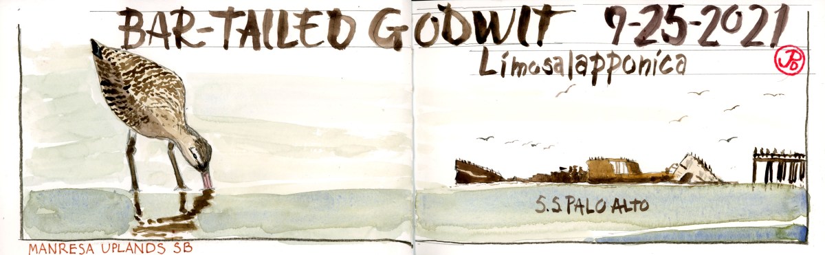
A rare godwit from Siberia has been hanging around with a group of marbled godwits on the Monterey Bay Coast in Santa Cruz County. And I was going to try and find it!
The bar-tailed godwit (Limosa lapponica) could easily be passed over when scanning a flock of foraging godwits. The differences can be subtle, especially if you don’t know what your looking for. The bar-tailed is slightly smaller legged and slightly smaller than the marbled (the difference in size is slight, marbled: 370 grams and the bar-tailed: 340 grams). The bar-tailed has a defined light supercillium (eyebrow) and it’s back is more darkly streaked than the commonly coastal marbled godwit.
This was either going to be a very easy find or a taxing struggle because the godwit flock could be anywhere on the long stretch of beach from Seacliff State Beach in Aptos to Sunset State Beach farther south in Watsonville. I anticipated a lot of leg work over sandy beaches to find the flock.
I first headed to the most northerly location where the flock had been seen: Seacliff State Beach. It is here that the hulk of the SS Palo Alto is rolled over on it’s port side like a huge, beached whale. I scanned the beach from the bluff. No godwit flocks. So I headed down the wooden stairs, used by locals as their personal gym, to the beach below. I headed south and there was a gull flock at the creek sans godwits. I returned to Highway 1 and drove three miles south. It looks like this godwit search was to become my own personal workout.
One of the best things about local birding is that it exposes you to new places, even in your own backyard. Such was the case as I exited Highway 1 at San Andreas Road and passed through La Salva Beach and headed further south. I turned right, heading towards the Pacific. My destination was the trail to Zills Beach. I reckoned that I was somewhere near or in Watsonville.
The trail to the beach that borders an agricultural field.
I headed down the trail, shouldering my scope and tripod. I reached the beach in about five minutes and looking to the south and the north, I did not see any shorebird flocks. Unfazed I decided to try my luck to the north, heading towards Manresa Beach. I set up my scope, to save some legwork, and scanned the water’s edge. I spotted some small peeps, in this case sandering. Beyond the sandering were some larger shorebirds which I hoped were godwits and if they were a flock of godwits, I hoped one of them had a white eyebrow and a darkly streaked back! I shouldered my scope and headed north down the beach to find out.
As I got closer I scoped the flock and indeed, confirmed that it was a flock of marbled godwits but I was too far away to identify a godwit that looked a bit different. As I came closer to the flock I came upon a family of five that was slowly heading up the beach. Lucky a pod of dolphins, frolicking in the inshore waters, was distracting them and they stopped to watch. They were heading towards the godwits too and I was hoping that they wouldn’t flush the flock before I had a chance to identify the bar-tailed. These shorebirds have wings and are at a distinct advantage, should the flock hightail it down the coast to Sunset Beach! That would be a lot of trudging in the sand. A good coastal workout I suppose.
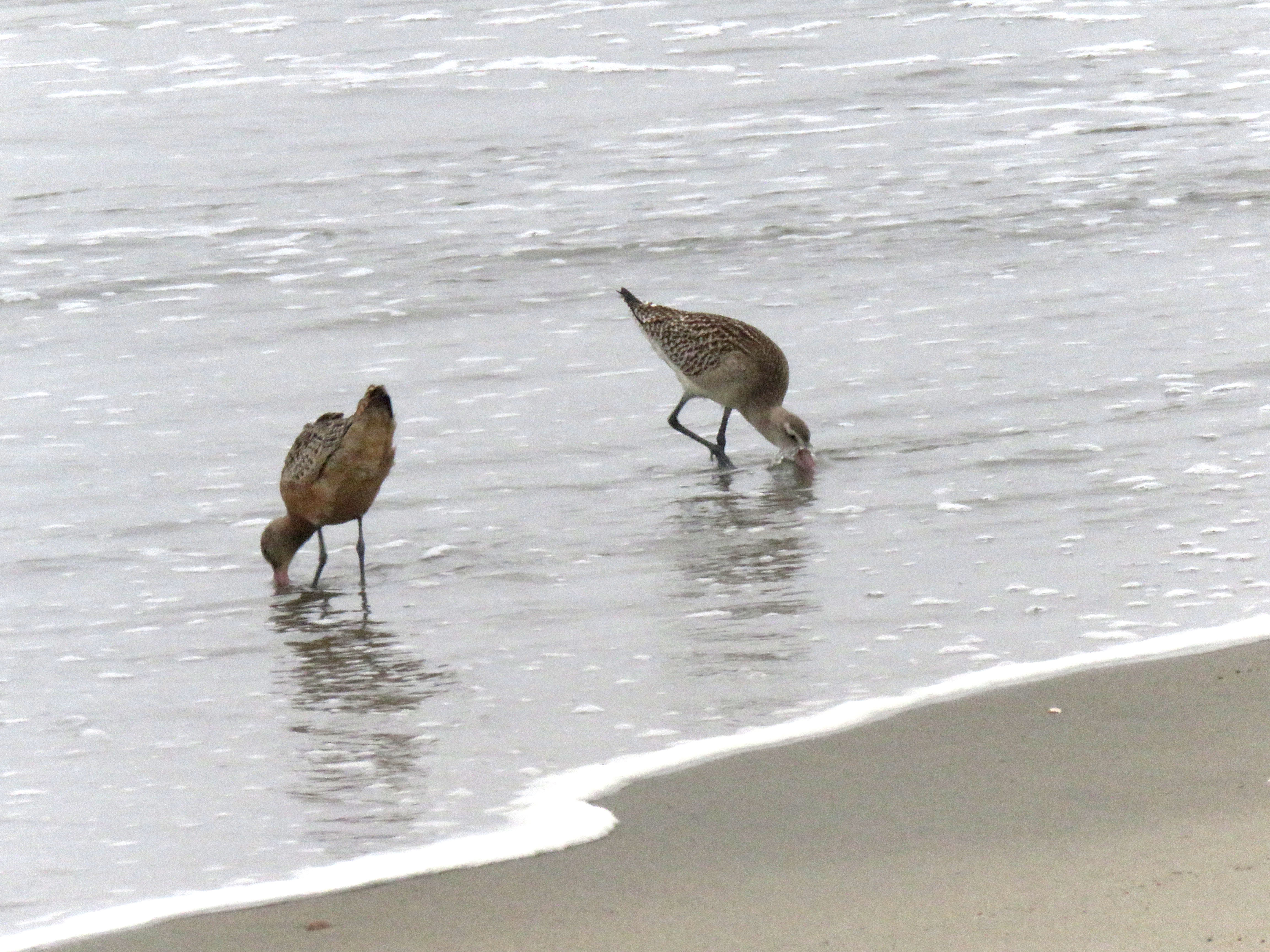
With the family of five preoccupied with dolphins, I headed away from the waterline, in a flanking maneuver to take me closer to the flock without flushing them. I set up the scope and scanned the godwits, left to right, looking for the one that didn’t quite belong. After a short search, I spotted a godwit with a light supercillium and a darker streaked back, compared with the nearby marbled godwits. Bingo! Bar-tailed godwit!
The bar-tailed godwit on the right and a marbled godwit on the left.
I spend about 15 minutes with the bar-tailed, getting scope views and taking photos before a a woman with golden retriever, who was heading south down the waterline, flushed the godwit flock. I traced the flock’s flight down the shoreline toward Sunset Beach. It was inevitable that a dog walker would walk along and send the flock to another part of the beach. At least the golden was on a leash. And I had some good looks at the bar-tailed godwit before it lifting into the air.
Here was an interesting find on the strandline, a former mola mola or ocean sunfish.
As I headed back south along the beach, I felt good about my Godwit Chase, not yet knowing that two more county birds would be added to my list on the following day. But this is a story for another spread and another post. Stay tuned!
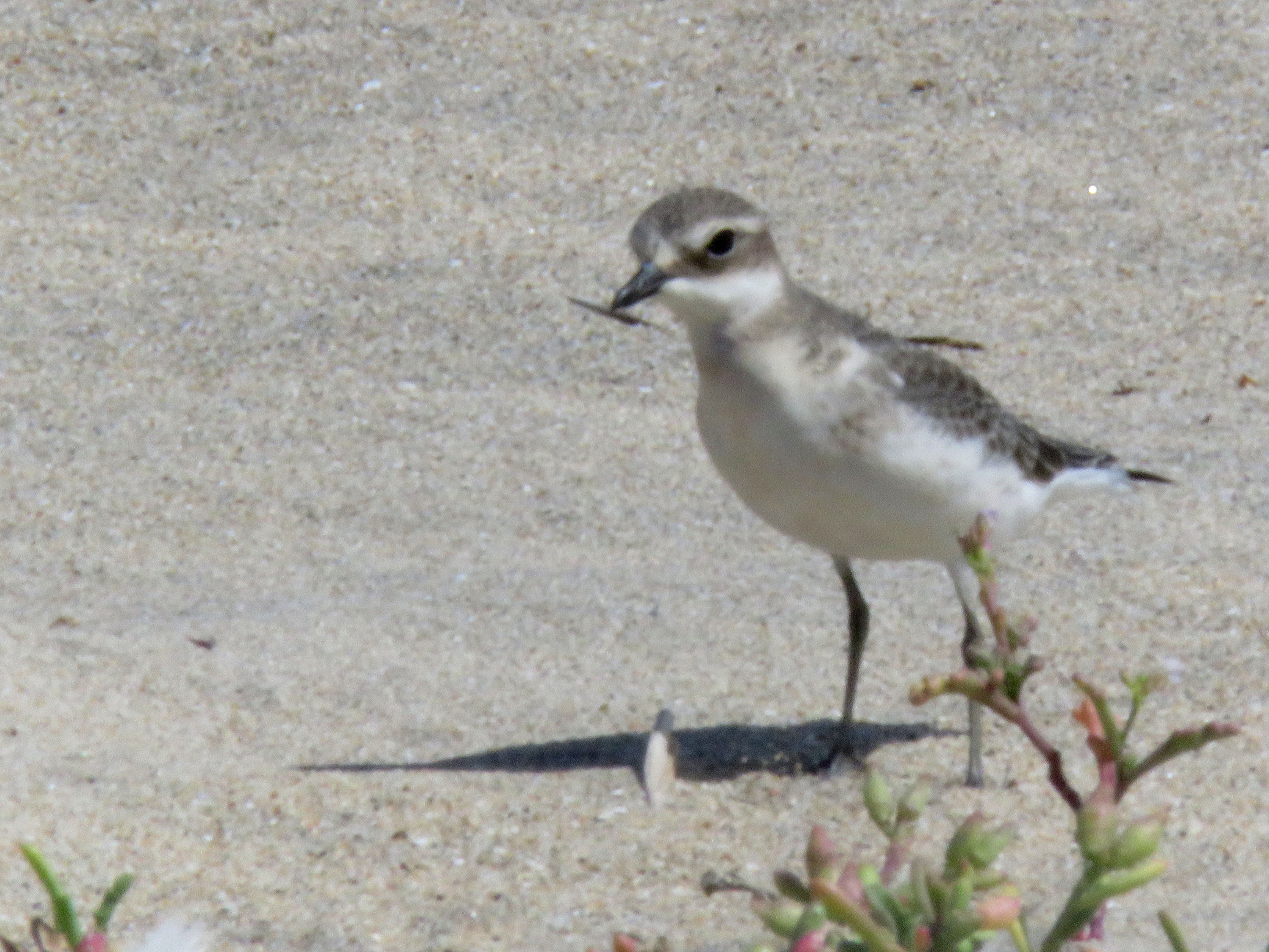
When I read the report of an extremely rare plover on a Santa Cruz County beach, I knew that I had to head down with GrassHopper Sparrow, to add this find to my county list! (This was a mega lifer for Grasshopper.)
This plover had only been seen in California on twenty occasions. And when it was first seen on the morning of September 17 by Simon Thornhill, he posted on a birding list serve: “Strange Plover at Laguna Beach”. He noted that the plover was slightly larger than the snowy plovers it was loosely associating with. He included a photo and it was identified by the birding community as a lesser sand plover (Charadrius mongolus).
I had first seen a Lesser Sand Plover in California on October 22, 2016 on Pt. Reyes Beach on the Outer Point of Marin County’s Pt. Reyes. This small plover is usually found in Asia (it was formally know as the Mongolian plover), the east coast of Africa, India, and Australia. So when one wanders into California is would have most likely crossed over from Siberia and headed south through Alaska, Canada, and the states of Washington and Oregon.
A rare plover in Santa Cruz County was a bird too good to pass up so Grasshopper and I headed to the coast on a Sunday afternoon. The weekend pumpkin patch traffic was surprisingly light and we make good time down Highway One into Santa Cruz County.
We parked in the dirt lot, crossed the highway, and started down the trail towards Laguna Beach. As we headed down the trail, we met three other birders coming up the trail. They where smiling and this is always a good sign! The rare plover was still present.
The birders gave us directions to where the sand plover was being seen and they predicted that we would find it in less than five minutes! Let’s hope this prediction comes true.
The wind off the ocean was whipping up the sand and I assumed the plovers would be hunkered down in the dunes about 40 yards from the waterline.
We first observed three snowy plovers in the dunes and we knew the sand plover must be close by. To distinguish a snowy from a sand is not a very tough identification. The sand is larger and uniformly a darker grey with a distinct white supercillium (eyebrow). And also most of the snowies on Laguna Beach were sporting jewelry, colored leg bands to help researchers identify individuals.
While I did not keep track of time, we did find a darker, slightly larger plover that was loosely associating with the snowies, within about five minutes! County lifer 262!!
A not-so-sharply-focused photo of the lesser sand plover on the sands of Laguna Beach.
We had the sand plover all to ourselves for about 15 minutes. Over the last couple of days the plover had attracted many birders to this almost forgotten beach on this Santa Cruz County beach.
County lines are a bit strange when it comes to off shore waters. They can seem arbitrary in the same way that county, state, or country lines can be. Only these county lines are drawn over deep water.
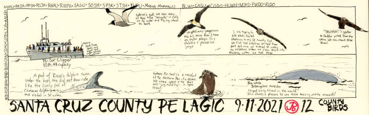
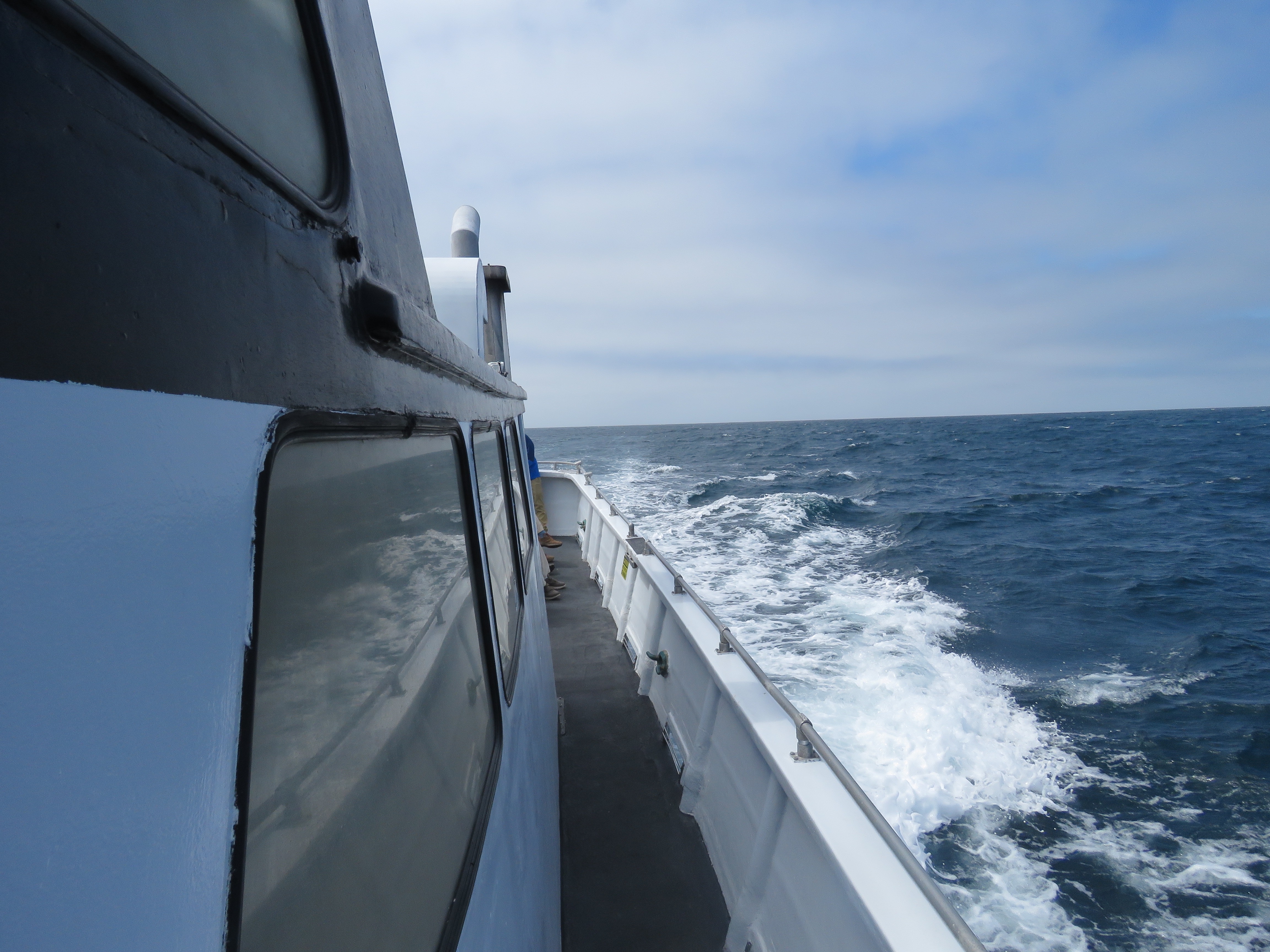
One of Alvaro’s pelagic boat trips was scheduled to head north from Monterey Harbor into Santa Cruz County waters. So I had to take this trip on my quest fro 300 Santa Cruz County birds.
Pelagic birding can be sublime and maddening in equal measures. For one, you are birding from a platform that is pitching in constant motion and the birds are often on a surface that is undulating where birds appear and disappear at a blink of an eye. Some birds fly to and over the boat while other birds, that had been resting on the water, take off at the first sight of a boat and you get a view of a retreating bird. Also because the bird boats are really designed for fishing and not pelagic birding, it is impossible to be two places at once. So if you are on the starboard rail and a rarity is seen on the opposite side of the boat, you have to make a mad scrabble on a surface that make one look like a drunk sailor, and only to find that the bird is gone with a spotter pointing to the spot where the Manx shearwater used to be!
I suppose this is the draw of pelagic birding. It is challenging and it can often give you incredible memorable experiences. Such as the time when our boat was surrounded my a pod of Pacific white-sided dolphins that numbered in the high hundreds or the time when we kept pace with two blue whales or another time when a black-footed albatross flew in and rest in the water a few yards from the boat.
We where scheduled to depart at 7:30 AM and at 7 a group of Santa Cruz Bird Club members where milling about, cleaning their optics and looking at gulls in the harbor. Our leader, Alvaro walked down the wharf. I was surprised to see him upright because he had flow in the night before from Spain, having just finished a birding trip. He said he felt fine but joked that if we found him asleep later in the afternoon we where to kick him awake.
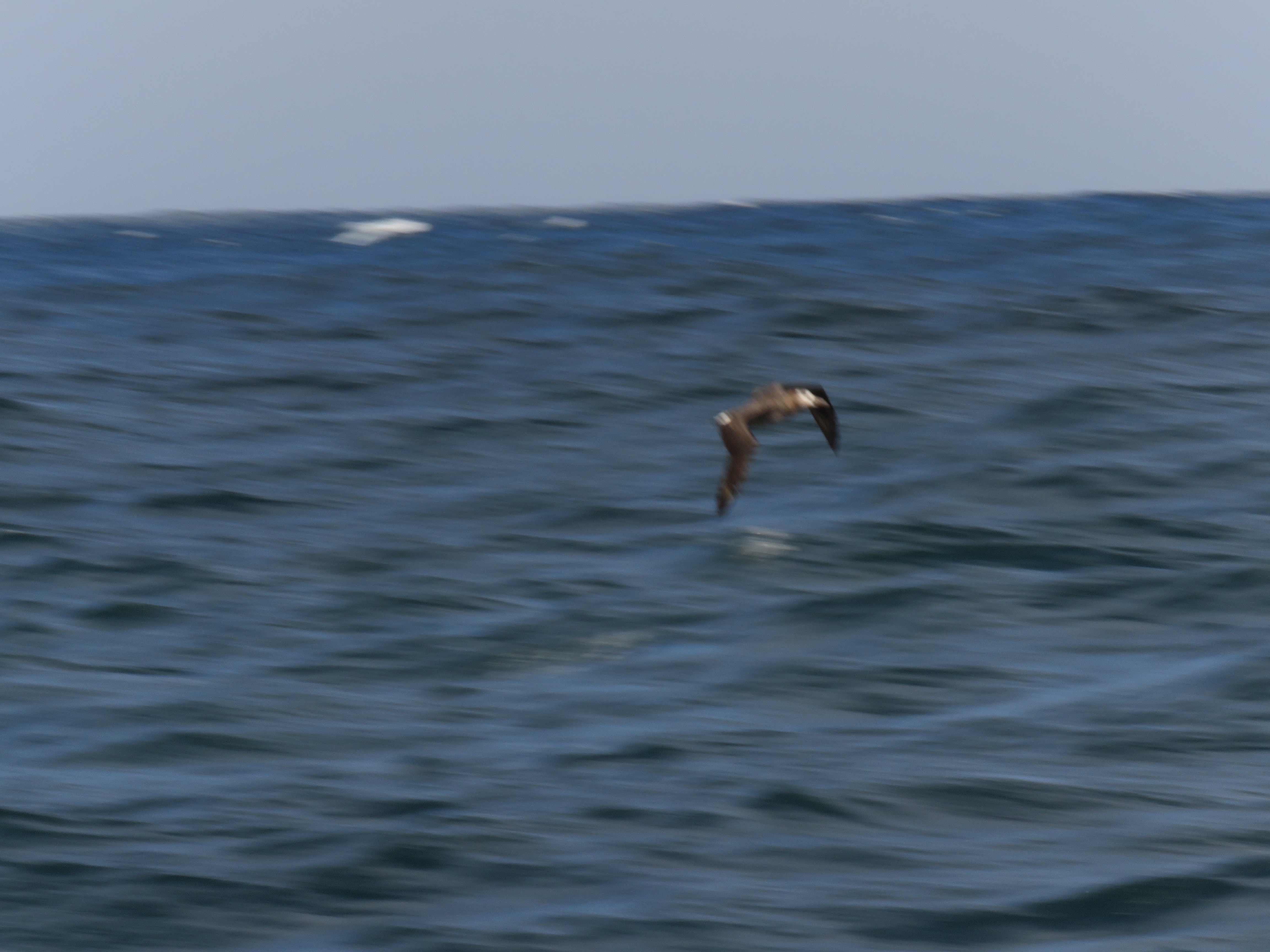
We left on time and we where only about an hour from port when we saw our first pelagic gem: the black-footed albatross. We soon crossed into Santa Cruz water and I wanted to add this albatross to my county list but unfortunately the four that we saw where all in Monterey waters. There where large numbers of shearwaters throughout our trip, the most common being sooty and pink-footed but with sightings of Buller’s and just one short-tailed and Manx shearwaters.
Looking down the port side of the Pt. Sur Clipper, or in pelagic birding parlance, 6 o’ clock to 9 o’clock. Here we are cruising above the Monterey Bay submarine canyon.
In all it was a very pleasurable cruise, even though I did not get an albatross over Santa Cruz waters, I did add 12 new county lifers, including: south polar skua, Arctic and common tern, Sabine’s gull, two jaegers, northern fulmar, Manx, Buller’s, and pink-footer shearwater.
As we headed back towards Monterey Harbor and the pelagic species where being replaced with inshore species like brown pelican, Brant’s cormorant, and western gull, there was one last surprise for use. One of the spotters picked out a far off brown booby flying along the coast. Not a bad way to ended a productive pelagic.
While we whiffed on black-footed albatross in Santa Cruz County, this photo of an albatross, blurred in motion over Monterey waters, sums up the motion and excitement of a classic Monterey Bay Pelagic.
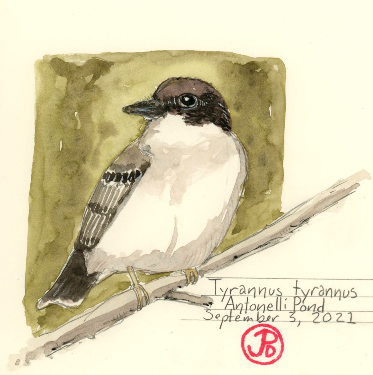
On a Monday, Trrannus tyrannus was first seen in a coffeeberry bush (Rhamnus californica) in the northwest corner of Antonelli Pond in Santa Cruz’s westside. I just hoped this county rarity would stick around until Friday when I could get down the coast to look for it.
The Eastern kingbird, like it’s name implies, breeds on the eastern side of the United States. This kingbird is a neotropical migrant where it spends winters entirely in South America. On their winters grounds, the kingbird travels in flocks and eats berries. (In the north it feeds mainly on insects taken on the wing).
Tyrannus tyrannus, means “tyrant, despot, or king” (take your pick) is named for the kingbird’s aggressive behavior during breeding season. While defending their nesting territory, they will attack birds that are much larger than itself, including hawks, great blue herons, ravens, crows, and even squirrels. There have been reports of kingbirds landing on the back of hawks and vultures, pecking and pulling out feathers. This is the King of Tyrants with a major Napoleon Complex.
So at about five PM I found myself in the northwest corner of Antonnelli Pond reflecting on the long journey this 40 gram bird had made, from the Amazon, eating fruit in flocks to it’s long journey up the Pacific Coast to forage for a few days near a pond in Santa Cruz. So far the coffeeberry bush was sans kingbird.
After about a 15 minute wait, a pied bird flew from the north into the bottom of the bush. I attempted to flank the bird to identify it as the wayward tyrant. A bird shot up from the bush, dark above and light below was a fine white border on it’s tail, Bingo! Eastern kingbird! The bird flew to a chain linked fence that bordered the Homeless Garden, where I was able to get a few distant photos.
A common perch for a kingbird: a fence.
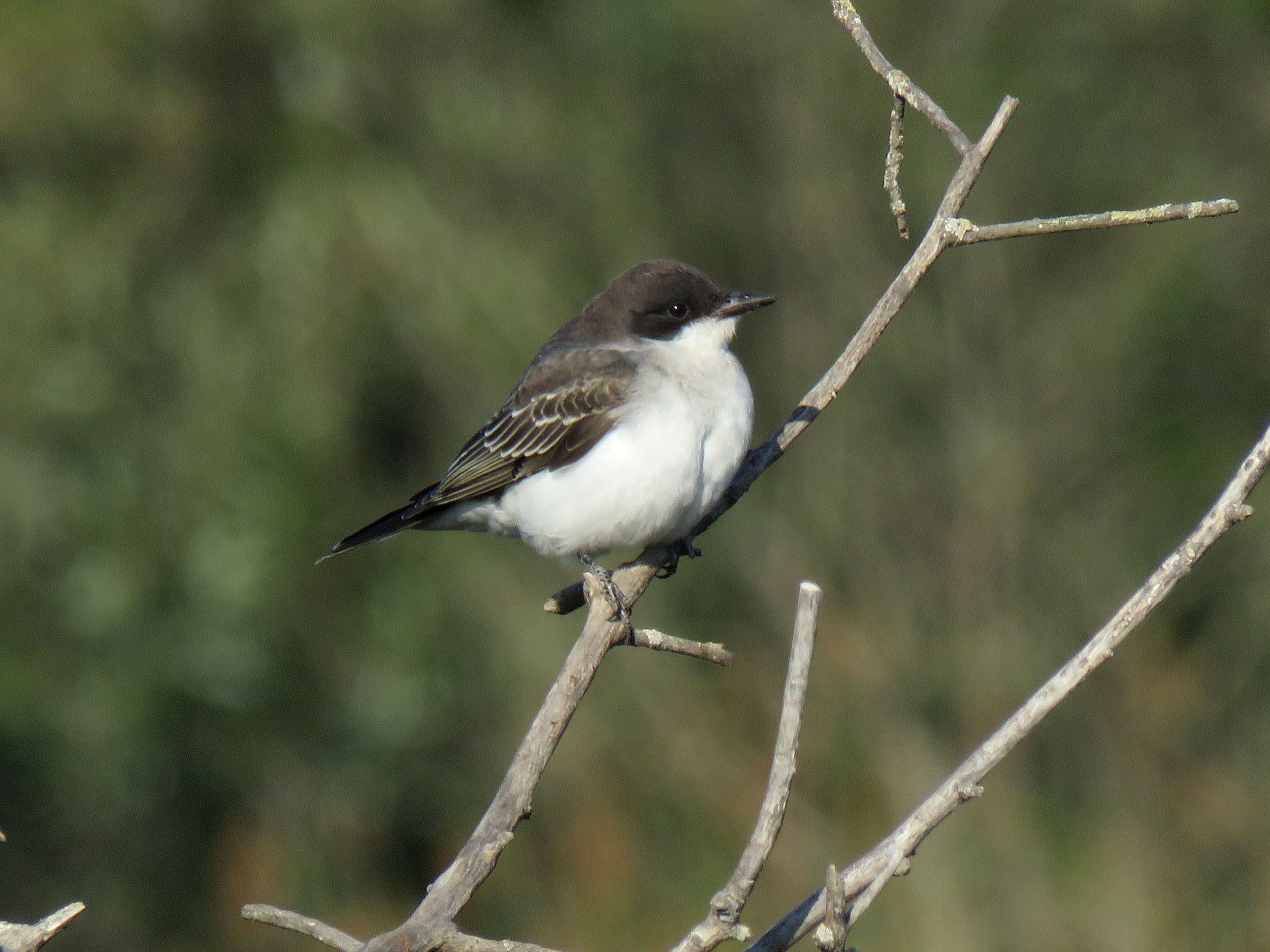
The kingbird foraged for a bit in the garden and then flew back and landed on top of the coffeeberry bush in perfect late afternoon light, so I had to take a few photographs to confirm it’s misplaced existence. It stayed on it’s perch for a few minutes and it then flew across the pond and my encounter with the wayward (is their such a thing in nature?) eastern kingbird was over.
The eastern kingbird in great light, showing off it’s kingbird profile.
Often when we are looking for one thing in nature we see so much more. This was the case on Saturday morning, when I returned to Antonelli Pond to look for the eastern kingbird again (and the willow flycatcher that had also been report). While the coffeeberry bush was lacking a kingbird, some movement in the brush in front of me caught my attention.
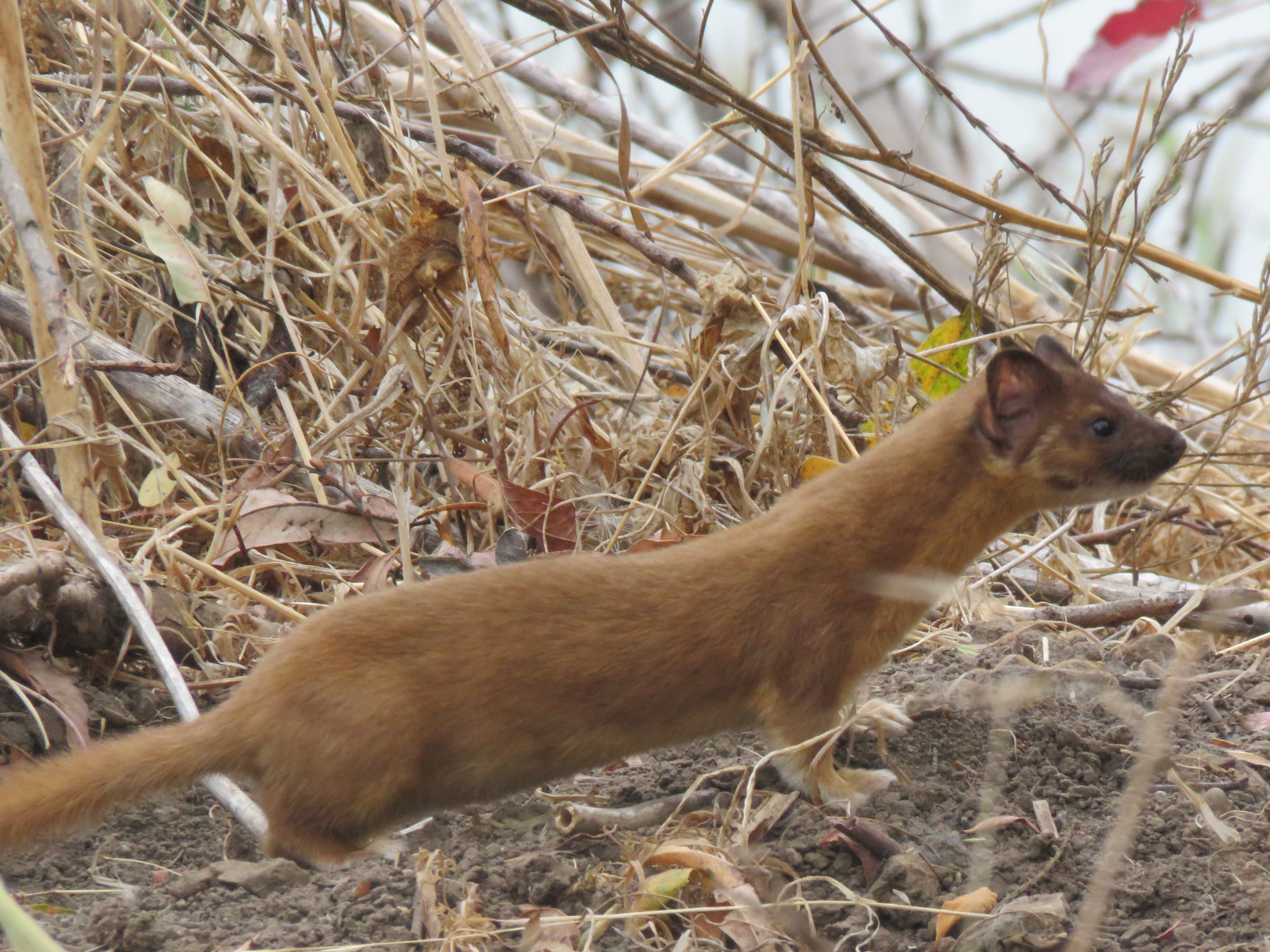
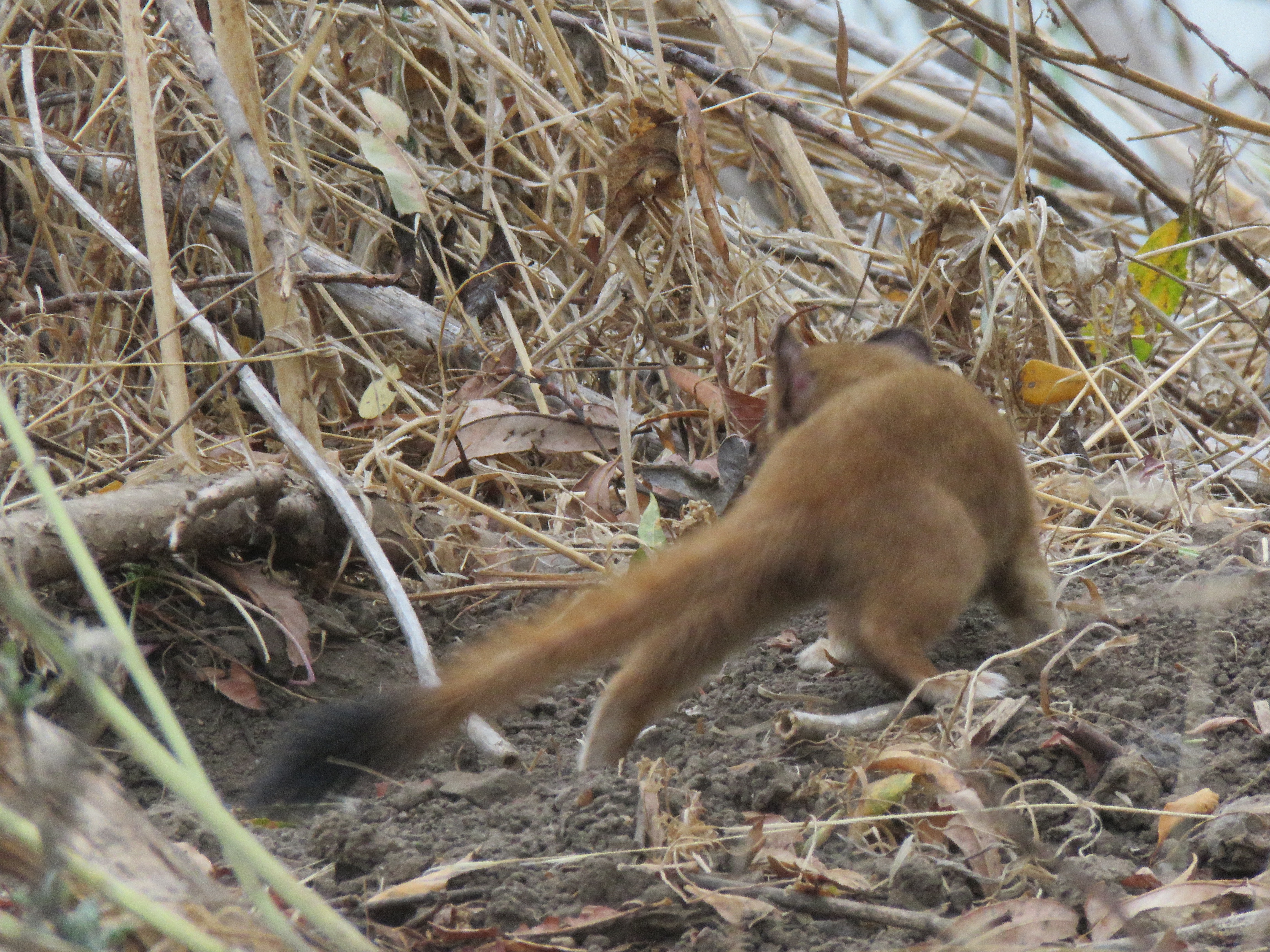
A caught a glimpse of a long mammalian predator. I wanted to entice it out to get a better look so I did my best impersonation of a wounded rodent (I was thinking mouse) and within seconds, it’s snake-like head, ears alert, appeared out of the brush. It was almost licking it’s deadly teeth with delight (I call anthropomorphism on myself!)
It was a long-tailed weasel (Neogale frenata)! I had seen this predator on two other occasions but both sightings (at Wilder Ranch) were fleeting and I just got a flash of it’s dark-tipped tail as it disappeared into coyote brush.
The long-tailed weasel is an aggressive predator which can take prey twice it’s size such as rabbits and squirrels. On one occasion at Wilder Ranch on the Old Cove Landing Trail, a weasel was hunting bush rabbits and I heard a lagomorphic scream that was hard to forgot. I was not sure if the weasel’s hunt was successful.
The long-tailed weasel, coaxed out of the brush with my wounded rodent impression.The long-tailed weasel showing off it’s black-tipped tail.