Image

Santa Cruz Counties Disappearing Wharves

The 2022-2023 atmospheric rivers (nine in total) dumped rain, strong wind, and storm surges on Santa Cruz County causing an estimated $100 million worth of damage.

In a 22 day period, the storm dumped 35.38 inches on the town of Boulder Creek in the Santa Cruz Mountains, 39.55 inches on Santa Cruz (a record amount) and left 15 feet of snow over Donner Summit. The storm systems dumped an estimated 32 trillion gallons of water on California and the storm left 20 people dead, including the man killed by a falling cypress in Lighthouse Field in Santa Cruz.

On Thursday January 19, the county got a very rare visit by a sitting president. The last president to visit the area was Theodore Roosevelt in May of 1903. There has to be some serious damage in order for the president to hop on Airforce One and fly cross the nation to the Monterey Bay Area.

President Biden visited the damaged Capitola Wharf and then headed to Aptos to view damage at Seacliff State Beach, home to the “Concrete Ship” the S. S. Palo Alto.

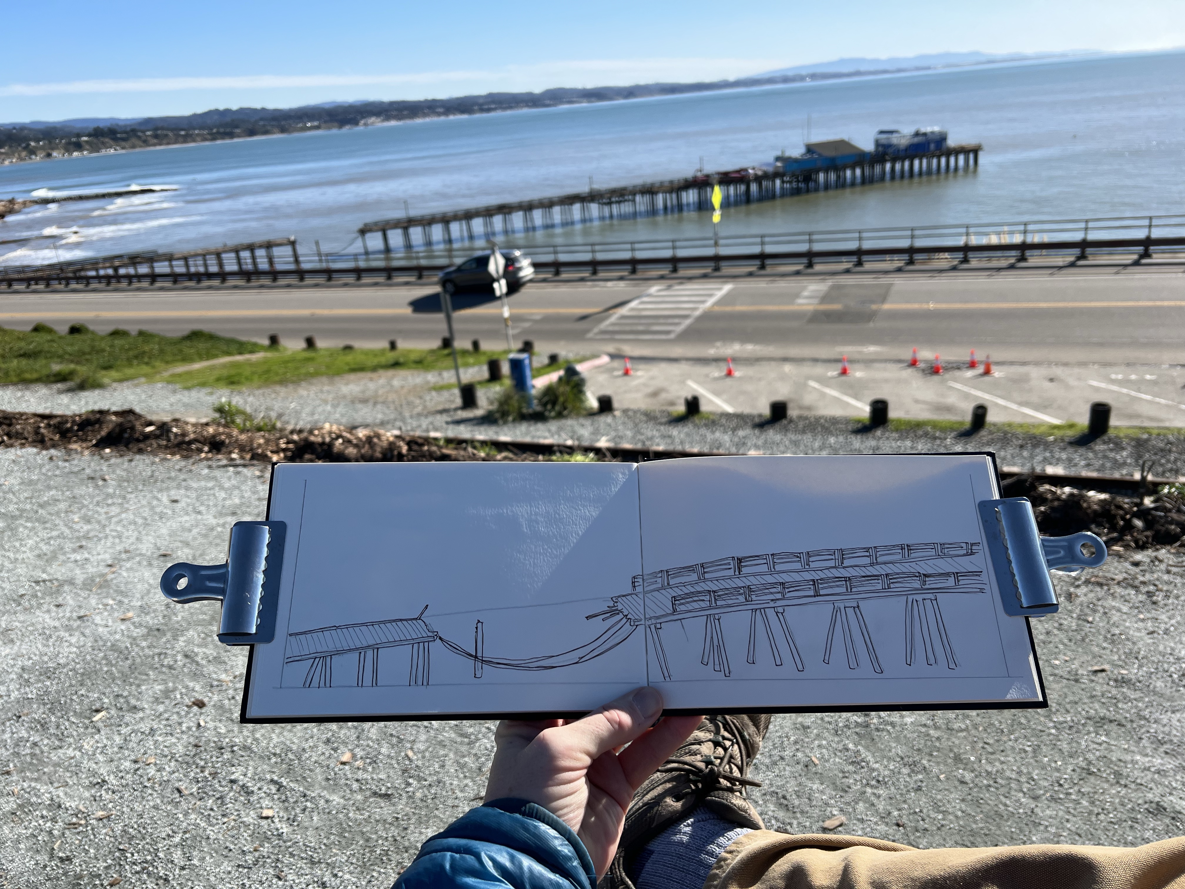
The Capitola Wharf was damaged by storm surge on Thursday January 5, taking out a 40 foot section of the 855 foot historic wharf, which was built in 1857. I intended to visit and sketch the wharf.

I weaved my way through residential streets of Capitola heading toward Capitol Village and the damaged pier. I found free parking on Prospect Ave (miraculously find!) and headed east toward Cliff Drive. The berm shrouded the beginning section of the wharf and as I walked east, the true damage appeared and it was shocking to see, even though I had seen photos and videos of the damage during news coverage.

Where’s the wharf?

Today was a beautiful winter day: clear skies, light wind, and temps flirting with the low 60s. I tried to image what the scene before me looked like 15 days ago. I tried to image the intense wind and rain and the 30 foot waves that engulfed the wharf, eventually taking large pieces of the wharf away and depositing them inside sea-fronted business. It was hard to image this on such a beautiful day.

I found a bench and opened up my Stillman & Birn Delta panoramic sketchbook and used my telephoto sketcher’s eye to zoom in on the damaged section on the wharf.

Using my sketcher telephoto view.

I then headed south on Highway One for a short drive to Seacliff State Beach in Aptos. It was here that the president viewed another damaged wharf and then gave a press conference about the damage he viewed and federal emergency funding.

From the upper parking lot I looked out to the segmented and ruins of the “Concrete Ship”, the S. S. Palo Alto. The ship had been torn into three pieces by a series of storms in the past but now it looked like the ship was further off shore than normal. This was really an optical illusion because the wharf that reached the ship’s stern was all but destroyed in the recent storms, leaving the Palo Alto looking like a rusting isolated island chain crowned in cormorants, gulls, and pelicans.

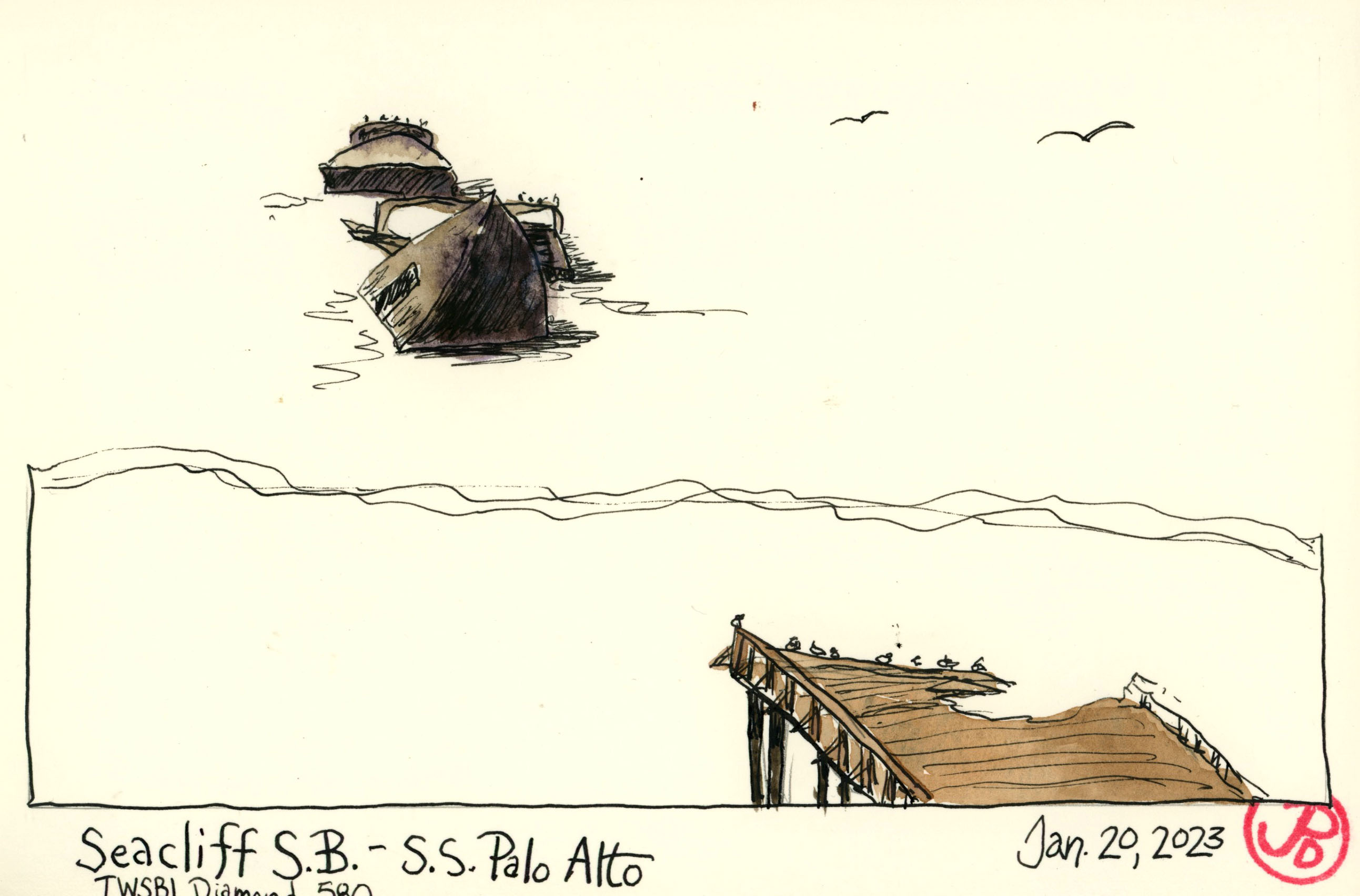
I sketched the ship with my new TWSBI Diamond 580 fountain pen. I had sketched this ship before in it’s various stages of decompose. I remember a time when I was a child when you could actually walk out on the pier and to the ship. Those days are long gone.

The destroyed wharf, the Palo Alto (in three parts), and the line of debris on Seacliff State Beach.

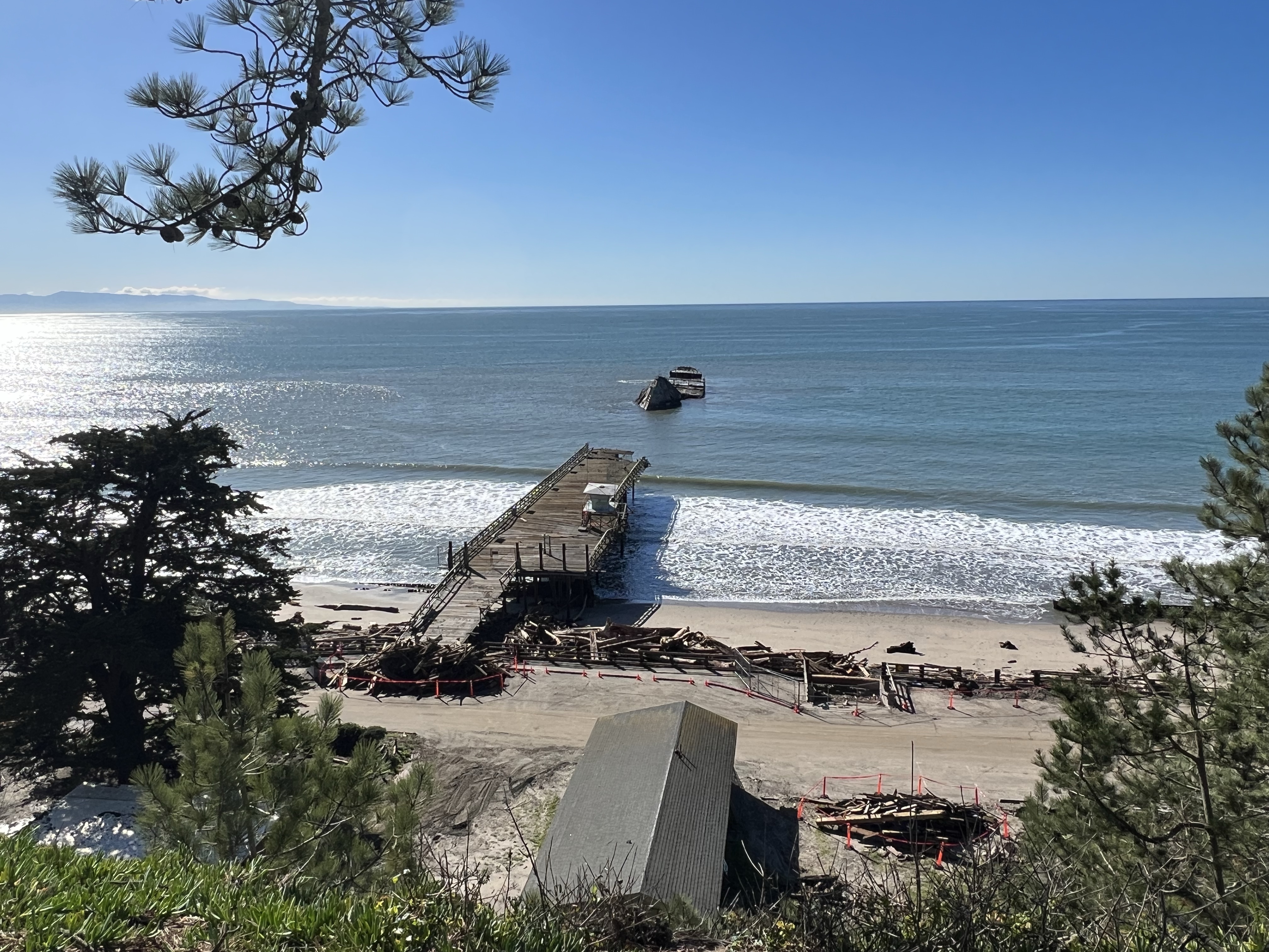
The Palo Alto was built at the end of World War I and launched in May of 1919. She was designed to be a tanker but was finished too late as the war ended. She was mothballed in Oakland and then purchased by the Seacliff Amusement Company in 1929. The pier was built in 1930 and the ship was used as an “amusement” ship with a swimming pool, a dance floor, and a cafe.

The company soon went bankrupt and the ship was sold to the state and it was then used as a fishing pier. Around this time the ship cracked in the middle during a winter storm. A February storm in 2016 pushed the ship on it’s starboard side and the ship is now in three or more pieces.

An Aptos mural by Ann Thiermann of the S. S. Palo Alto in better days. That man shouldn’t be feeding that pup ice cream!
Image

My Little Sketchbook: Airports

To me, there is no better way to pass time in an airport than sketching.

I always have my small Stillman & Birn Delta Series in my pocket. The reason I enjoy using this 3.5″ X 5.5″ soft-cover sketchbook is that it allows me to do quick sketches. There is not so much paper to cover as a “standard” sized sketchbook. If sketching because more easy, you tend to do more of it.

I always try to take a seat, facing a window and sketch the planes on the tarmac as they are lined up like a school of sharks at their gates. I try to sketch the plane I will be departing on. But any plane will do.

I have included a few of my sketches in this post. They were done at SFO (San Francisco) and DCA (Reagan International).

Image

Journals of the Civil War

Before I go one any trip I like to add a title page and a map to my sketchbooks.

For my trip to Civi War battlefields in Virginia, West Virginia, Maryland, and Pennsylvania I chose to bring two Stillman and Birn hard cover watercolor journals. One is my new go-to favorite, the panoramic Delta Series journal. And the other is a Beta Series 5.5 ” X 8.5″ sketchbook. I love both of these papers and they are great for sketching on the road with pen and watercolor.

In the Delta journal I created the title page based on the famous image from Ken Burns’ documentary The Civil War, of a silhouetted canon and a glorious sunset in the background. This footage was filmed at Manassas in Virginia. This opening page is the featured sketch.

In my Beta sketchbooks I created a map of the places I would be visiting. All of the locations I would be visiting where within 90 minutes of each other. I distressed the map, covering it in mud and blood. Perhaps I added too much “blood”, but somehow since this is the Civil War it was fitting. It is estimated that about 620,000 Americans lost their lives during the Civil War.

In my Beta, created to spread to synthesize a lot of the information about my trip in a creative way. It is a montage of all the important facts of the trip. Well some of them at any rate. This was a fun page to do and involved a few different sketching techniques.

Image

Trails, Roads, & Rails

“The landscape of the American West has to to be seen to be believed, and has to be believed to be seen.” -N. Scott Momaday

I have many summer memories of road trips across the West.

Often our family trips were to the north through Oregon, Washington, and dipping into southern British Colombia. On another road trip we visited Monument Valley, the incredible Grand Canyon, and the underwhelming Four Corners in our Volkswagon Vanagon. On the same trip we rode on one of the United States’ most famous railroads, the Durango and Silverton Narrow Gauge Railroad.

To celebrate summer and the purchase of a new car (a 2021 Subaru Crosstrek Sport), I decided to take a road trip in the West. My intended destinations reflect my many interests.

My new Adventure-Mobile.

For birds I intend to visit the Ruby Mountains in Nevada for the legendary lifer Himalayan snowcock and Rocky Mountain National Park in Colorado for white-tailed ptarmigan and broad-tailed hummingbird. For history I want to visit Fort Bridger in Wyoming, parts of the Hasting’s Cut-off in Utah, and the California Gull Monument in Salt Lake City. For rail history I planned to visit the Ames Monument in Buford Wyoming, Union Station at Ogden, Utah, and the ground zero of Union Pacific’s steam program, Cheyenne.

For roughly 1,000 miles I would be traveling east on Highway 80. Like the Transcontinental Railroad before it, I-80 is an east-west transcontinental highway. At 2,899 miles it is the second longest highway in the United States, after I-90. The highway was created in 1956 as part of the original interstate highway system.

As I do before any important journey I sketch out the route. In this case I chose to represent the map as a distressed treasure map or perhaps a map to a secret goldmine, like Dr. Buckbee’s map in the Gold Rush classic By the Great Horn Spoon.

I have been a big fan of Stillman & Birn sketchbooks and I love the heavy weight of the cold press, ivory paper of the Delta Series. What I don’t like is that I have not found this high quality paper in a hardbound panoramic sketchbook, until now!

While I was picking up pens at California Arts Supply I was ranting (once again) to the owner Ron about how I wished Stillman & Birn would make a Delta Series hardbound panoramic sketchbook. He told that they did have such a sketchbook, newly arrived! I bought one as my road trip journal!

Finally an improvement on the Moleskine panoramic sketch book that has been my go to journal for years but with better paper. The paper is 270 g, ivory cold press. When opened the panoramic format gives me a 6 X 18 inch painting surface! Perfect for the land of vast vistas! Or painting a very tall tree or tower in the vertical format.

Image

A Sketcher’s Prep

Before any great journey, I do some sketcher’s prep.

In this case, the featured sketch, is a spread about my Colorado birding wishlist featuring such birds as scaled quail, sharp-tailed grouse, American three-toed woodpecker, and white-tailed ptarmigan. I did quick thumbnail sketches of each species, in other words, you would never use this spread as an identification guide.

While these sketches are no where near David Allen Sibley standards, they help me to see each bird better. To sketch from a photo requires close attention, once when the sketch is penciled in, then when it’s inked and finally a third time when the image in painted.

I also wanted to use a new travel palette for Colorado and I documented it’s creation in another spread.

I first sketched out the layout of my new palette in my landscape Delta Stillman & Birn softcover sketchbook. As I added each color to the wells of the palette I painted it in and added a swath on the opposite page. This will provide a good reference of what the colors look like on the heavy weight Delta paper.

I love using Stillman & Birn sketchbooks and I love the feel of a panoramic, landscape format but I dislike the fact that this book is not made in hard cover but softcover only. It does not provide a solid sketching surface to paint on. I will see how this book holds up on this trip.

I also carry a small notebook that help me prep before a trip. I writing down my itinerary, addresses, lodging information, any travel notes, random poems, target life birds, and a targeted sketch list.

Image

California Zephyr and Southern Pacific Ghosts

On a Saturday morning I drove over the Bay Bridge to the Emeryville Amtrak Station to sketch the California Zephyr Train # 6. This is the train I booked a roomette on back in April. I had to cancel the trip because of the pandemic. This route usually runs seven days a week but with the current Covid situation, it now runs just three times a week: Tuesday, Thursday, and Saturday. Unfortunately I would not be board the train, although it was very tempting!

I wanted to challenge myself to do a quick sketch because I didn’t know how long the California Zephyr would be at the platform before it departed. I guessed I would have at least 15 minutes because the engineer stepped out of the cab and walked down the platform to a get a packed lunch while the conductors assisted with boarding. I liked the ephemeral nature of this challenge because unlike a piece of sculpture or architecture, the Zephyr was not going be here for long. For this task, it helps to have a smaller journal so I went with my Stillman & Birn Delta Series 6 X 8″ sketchbook.

California Zephyr # 6, pulling into Emeryville Station. This is one of Amtrak’s longest routes. In three days time it will end it’s journey in Chicago. Note the cowboy hat in the window. This consist was a little odd because it contained three instead of two locomotives. It also did not include a baggage car, so the Zeph has no baggage.

I also wanted to work with perspective by sketching the train as it reversed toward my eyeline and vanishing point. If you don’t get the perspective right, the whole sketch can fall apart. That’s why it’s best to lay in your perspective lines in pencil.

Emeryville is the western terminus of it’s 2,438 mile journey and train number 6 pulled into the platform at 8:45 AM to take on it’s first passengers. I first established where my eye or horizon line was by holding my pencil straight out at arm’s length and closing one eye. I added the line to my sketch. I then blocked in the position of the front of the locomotive. Next, I added the vanishing point on the eyeline. This is where all the lines of the receding train converge. Now it was about adding shapes and details and then inking the sketch before the Zephyr departed at it’s schedule time of 9:10 AM.

Eastbound California Zephyr heading out towards the north and eventually climbing out of the Sacramento Valley up into the Sierra Nevada Mountains towards the legendary Donner Pass. On the platform, wearing a red coat, is a fellow train nerd. In three days and 2,438 miles later, the Zephyr will end it’s journey in Chicago.

After the California Zephyr departed, right on time, I headed south into West Oakland to take a look at the old station that Emeryville Station replaced. This is Oakland’s 16th Street Station.

The current building was designed by architect Jarvis Hunt in a Beaux-Arts style and completed in 1912. It was Southern Pacific’s main passenger station in Oakland. Passengers could take ferries from Oakland Pier to San Francisco, which was two miles away.

Once the Bay Bridge was built, in 1936, it put an end to ferry service and passengers then could take buses over the bridge to get into San Francisco. In 1971, Amtrak took over passenger service from Southern Pacific.

On October 17, 1989, the Loma Prieta Earthquake struck, severely damaging 16th Street Station. The earthquake also damaged the Cypress Structure, which was parallel to the railroad tracks. 14 blocks of this double deck freeway structure, collapsed or was damaged starting at 16th Street and heading to the MacArthur Maze. In total, 42 people lost their lives here. The most in any single location.

In the 1990’s, the rails were removed to make way for the construction of the 880 Freeway which replaced the Cypress Structure and 16th Street Station was left marooned without rails. The station was closed on August 5, 1994.

The abandoned 16th Street Southern Pacific Station. This was once the terminus of the superliner, the City of San Francisco.

From 16th Street Station I headed two miles to the Oakland Pier. This was once the busy hub of Southern Pacific’s Western Division. Oakland Pier was one of the busiest rail terminals in the country handling 763 trains a day and 56,000 passengers in a 24 hour period.

To control all this rail traffic, the Oakland Pier Control Tower made an average of 1,900 switches in a day! The majority of railroad tracks are now gone and the Oakland Pier is busy with shipping and truck traffic. The only reminder of this busy railroad hub is the remaining control tower.

The massive Oakland Pier interlocking control tower. The two poles to the right were used for “hooping up” orders, which was a way to pass orders to a train in motion. Using these poles to transfer train orders meant that the train did not have to stop to pick up orders. The tall pole was either for the engineer or fireman and the shorter one was for the conductor in the caboose.
Image

The Godwit Trifecta

It’s not every day that you see three species of godwit on the west coast in one day. But Monday October 21, 2019 was the day and I was going to try for them after work.

I had seen all three godwits before but not all at the the same place. Marbled godwit is a common bird this time of year on the coast or bay. Hudsonian was rare on the coast. The last time I’d seen one was in Alviso in September of 2003. And I had just seen a bar-tailed godwit in the spring. It’s a common bird, if your in Europe, which I was, but rare in Coastal California. I had picked one up as a lifer in the Ebro Delta in Spain.

My first stop was Pescadero State Beach, where the previous week, all three godwits were present. Now only the Hudsonian and marbled remained. It was just a mater of finding it.

Along the long narrow beach that stretched out to the north I could see nothing but gulls, lots and lots of gulls. What I needed to find was a group of godwits. I couldn’t see any from here so a little leg work was called for. So I took a sandy step off to the north.

After I passed the large gull roost I found what I was looking for, a small group of shorebirds. I could make out a few whimbrels, long-billed curlews, and yes, some marbled godwits. It took all of my effort not to raise my bins to my eyes but I resisted the urge. I needed to get closer and head a little to the west to get the low sun at my back to help me find that one godwit that looked a little different.

IMG_6454

One of these birds does not look like the others.

Most of the godwits were roosting, balanced on one leg with bills tucked under their back feather. Once I put bins on the group I immediately saw a smaller, over all gray and not rufous godwit with a dark cap and a defined bold supercilium or eyebrow. I was looking at a Hudsonian godwit for the first time in almost 20 years!

Hudsonia sketch

A field sketch of the resting Hudsonian in a Stillman & Birn Delta Series softcover sketchbook.

I guess I would just have to be satisfied with a two Godwit Day when Dickcissel texted me that the bar-tailed godwit had just been refound 10 miles to the north at Tunitas Creek Beach! So I rushed back, as fast as I could with a scope and in sand, to the parking lot.

Off I headed on Highway One and pulled off on Tunitas Creek Road (one of the most haunted roads in the United States) and parked. Then it was down the hill, along the path, up the steep hill, through bramble, along the hedge cave, past the creek and concrete wall to the expanding views of Tunitas Creek Beach.

IMG_6622

Tunitas Creek and the beach, looking southwest.

I scanned the long and narrow beach from the north and to the south. Nothing but gulls. Déjà vu.

What I needed to find was a group of godwits. I couldn’t see any from here so a little leg work was called for. So I took a sandy step off to the north.

All gulls and no godwits.

I was stopped by some friendly locals with their pooch and they asked what I was looking for. I expanded and they asked if I’d seen the heron by the creek. I told them that I had and that birding is an affliction and I had to find the godwit before I lost light. And off I went to the south. Not sure they understood, it is an affliction after all.

About halfway down the beach I saw the silhouetted forms of shorebirds. I had to head southwest of their position to get the sun at my back to identify them. A group of godwits. I scanned the flock. All marbleds.

I looked to the south and moved on. In a sandy depression in the beach, I saw the silhouetted forms of shorebirds. I had to head southwest of their position to get the sun at my back to identify them. A group of godwits. I scanned the flock. I found marbled godwits and one bird that looked like no other. A bird foraging with the flock but was a little apart from the rest. Bar-tailed godwit!

IMG_6515

Bar-tailed godwit at Tunitus Creek Beach,

Now after attaining the Godwit Trifecta I could head back north towards home, reveling in a very satisfying Monday afterwork Birding adventure.

I would sleep well tonight!