Image

Twain in the Gold Country

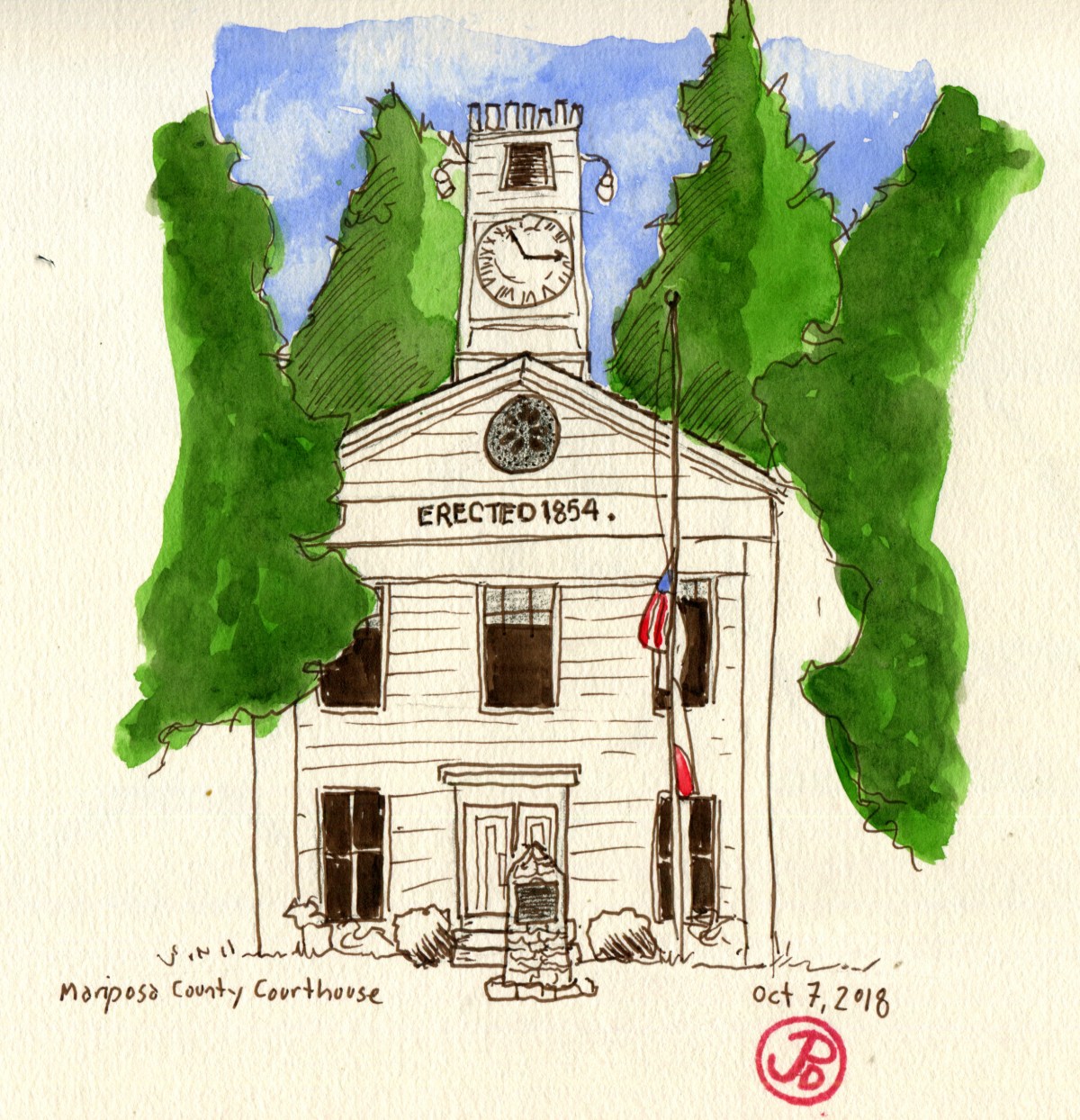
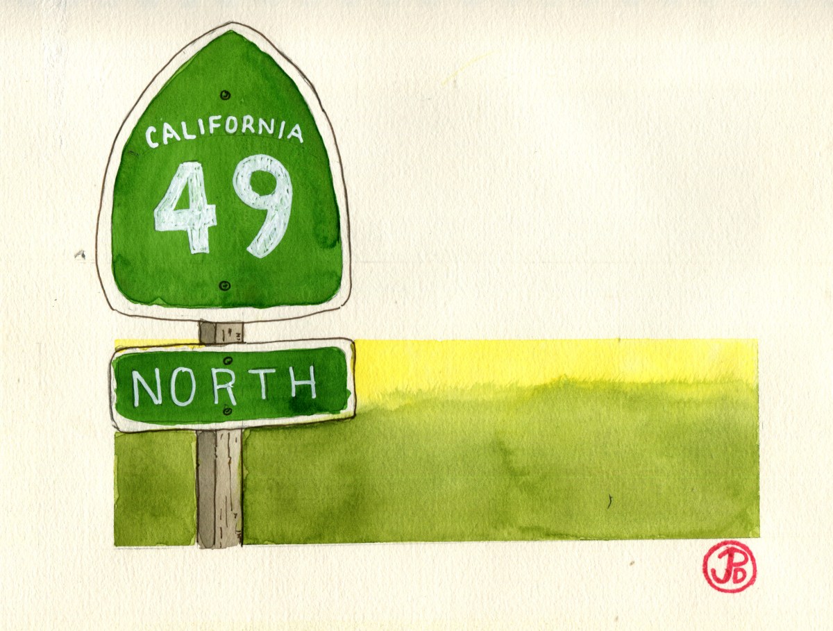
When Mark Twain’s name is mentioned, steaming paddle boats on the Mississippi River comes to mind. He is, after all, the author of what has been called the “Great American Novel”, The Adventures of Huckleberry Finn. The setting is firmly placed in the Antebellum South. So why is it that on Highway 49, near Tuttletown, there is a historical marker (No. 138) with Mark Twain’s name on it?

It was in California’s Gold County that the 30-year-old journalist, Samuel Clemens (aka Mark Twain) spent the winter of 1864-65 in a cabin up on Jackass Hill. The cabin belonged to the Gillis Brothers, who where local miners. Maybe this fact alone would be worth a historic marker on 49 but it is what he did when he went into town and visited the saloon in the Angels Hotel in Angels Camp, ten miles north of Jackass Hill. What he did was presumably, have a drink and listened to a tall tale.

That tall tale became the short story, “The Celebrated Jumping Frog of Calaveras County”, which was first published in the New York Saturday Press on November 18, 1865. This is the short story that is credited with setting Twain on the road to literary fame. It was in the rainy winter that he discovery his fortune as Twain noted, “right in the depths of [the miners’] poverty and pocket mining lay the germ of my coming good fortune.” He saw his 88 days in the Gold Country as the turning point of his life.

And so it was that I turned off Highway 49 and headed up a narrow road to the top of Jackass Hill. At the top was the Gillis Cabin. The building itself was surrounded by a fence, as if it was an animal at a zoo. The cabin itself is a replica of the original. The original succumbed to the plight of many wooden structures of the day: engulfed in flames. The chimney, however, is original to the time when Twain stayed here.

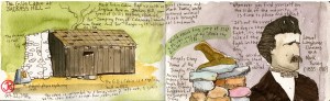
I set up my folding camp chair and sketched the cabin sans fence. I felt like I was sketching at the zoo. Except my subject stood stock still.

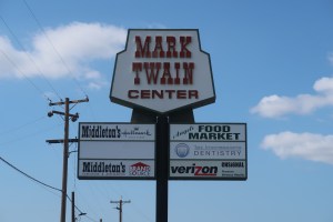
After sketching, I heading back down Jackass Hill and continued north on 49 to the town of Angels Camp. In town I sketched the frog historical marker which is across Highway 49 from the site where Twain first heard the yarn about the leaping frog of Calaveras County and also put Angels Camp on the map. All on account about a tall tale about a frog.

They really celebrate Twain’s short time in the area with Calaveras County Fair and Jumping Frog Jubilee which is held in May. The frog jump contest just celebrated it’s 90th anniversary last May (2018). This event is held in Angels Camp and is billed as one of the oldest such events in California. It is billed as one of the oldest Faires in California.

Image

Miner’s Justice

One of the first sketches I did on my Highway 49 road trip was of the Mariposa County Courthouse. This stunning courthouse is the oldest seat of justice in California. The courthouse was completed in 1854 and has been in use ever since. In fact when I visited the courthouse on Tuesday, I went up to the courtroom chambers above the entrance and they were conducting jury selection for an upcoming trial. I was relieved at this time that I was not a resident of Mariposa County!

Many famous legal battles regarding miner’s rights and claims were fought in this very courtroom and here it was, still in use!

IMG_4623

Solving disagreements in a court of law was a new thing in the wild west of the Gold Rush days. It was was more common in miner’s camps for disputes and crimes to be solved by miner’s “rough” justice. And sometimes on the branch of a oak tree in Hangtown, which now bears the name Placerville. The Hanging Tree is now long gone but further north on 49, 30 monies from Nevada City, I saw Downieville’s version of their hanging tree.

Downieville has the dubious distinction of lynching the only woman in the State of California and it is in Downievillie that it is the only place in California that they have their gallows on display.

Gallows

The gallows was last used on November 27, 1885 when 20 year old James O’Neill was hung to death for the August 7, 1884 murder of his employer John Woodward. This execution was the last legal execution in Sierra County and it was they only time the gallows was used. At the time the gallows was constructed it was only set up temporarily for it’s sole purpose and then it was disassembled and placed in the courthouse attic for storage. In 1891, local executions ended, being moved to San Quentin and Folsom prisons and in 1941 the state banned hanging as a means of execution in favor of San Quentin’s gas chamber. Isn’t history great?!

Image

Highway 49 Road Trip

California Highway 49 runs north and south, winding 310 miles through California’s Gold County. It passes through eleven counties and 51 cities, towns, and settlements. It is perhaps California’s most historic highway and I was going to drive all 310 miles of it, starting at it’s southern terminus at Oakhurst to where the highway ends at it’s northern terminus at the junction with Highway 70 at Vinton.

My guild throughout my road trip was the green, spade-shaped shields that read: CALIFORNIA 49. NORTH. The shape of the sign is a reference to the spades used by Forty-Niners to dig for gold when the world rushed in during California’s Gold Rush in 1849. The state highway agency adopted this symbol of the Gold Rush in 1934 and has been used ever since on all of California’s state highway signs.

The first Highway 49 shield at the start of the highway in Oakhurst on my first day of my road trip.

I could drive the entire highway in one very long day but I chose to break the road trip up into a five day trip, giving me time to explore the towns, back roads, and historical points of interests along the way. And of of course encountering the landscape and townscapes in the same way that many immigrants did in the 19th century, in the pages of a sketchbook.

The northern end of 49 at the junction of Highway 70 in the beautiful Sierra Valley.

In the next blog posts, I will features sketches in the many places I visited on my road trip on historic Highway 49.

The northern section of Highway 49 is the most scenic as it runs through Sierra Valley at 5,000 feet.

Image

Me and a Dipper

I came down to the valley to sketch the monolith El Capitain but instead I stopped at the banks of the Merced River, Bridelveil Falls falling silencing across the valley and I sketched a dipper.

It says a lot about the American dipper that John Muir devoted an entire chapter of The Mountains of California to this small, drab bird. The water-ouzel, as the dipper was known then, rewards the observer with the amount of time put in by simply sitting down on the river bank and watching.

The dipper is seldom still, making sketching a challenging yet exhilarating experience. Just when you start one sketch you stop and restart because the dipper has disappeared under the river, appearing again, perched on a submerged rock, making the bird appear to be standing on water. And the dipper never just perches. Like it’s name implies, it it constantly dipping it’s body up and down.

As so I passed part of my morning in Yosemite Valley, with my back facing the largest chunk of granite in the world but my eyes focused on one of the most captivating creatures to be found in any National Park: the American dipper.

And as Muir wrote about the dipper, “Among all the mountain birds, none has cheered me so much in my lonely wanderings, -none so unfailingly.” And I couldn’t agree with John Muir more.


Image

Obata’s Yosemite

I left the Wawona Hotel before light, my destination was Glacier Point and I hoped to have the place to myself (if that is ever possible in this very popular National Park).

The view from Glacier Point is probably the best view in Yosemite, if not the entire National Park System. Right in front of you, Half Dome rises up and leaning over the rail, you look down into this famous glacier-sculpted valley.

IMG_4670

It was a beautifuly crisp fall morning above the valley and as I sketched Half Dome, I had the point to myself for a whole six minutes! An eternity in Yosemite, these where geological minutes.

IMG_9721

I’ve got the place to myself, well at least for another two minutes!

I chose to use a loose, brush technique, inspired by the paintings and woodcut prints of Chiura Obata (1885-1975). Obata’s images of Yosemite and the Sierra Nevada Mountains, are as iconic to me as a Bierstadt or Hill painting or an Ansel Adams photograph. I love this Japanese ascetic that he brings to a very familiar subject.

Obata immigrated from Japan to the United States in 1903. Obama became a well know teacher and artist in the Bay Area and every since visiting Yosemite for the first time in 1927, this National Park has become a major subject matter in his artist output.

Obata Half Dome

I tried to resist the urge to head to the valley floor which is usually crowded with people, even in October. One of the other most iconic views of Yosemite Valley is the one you get at Tunnel View. While all the tourists took selfies and photos, I sat on a stone wall and sketched this famous view, trying to summon my inner Obata.

Obata Tunnel View

Image

Summer Camp

They say you can never go back to summer camp as an adult but I was sure going to try.

Like most childhood memories, the setting is often divorced from the memory itself. I find this out almost every Monday when I learn that one of my students has gone camping over the weekend. My first question is, “Oh, where did you go camping?” The inevitable answer is, “Ahhh. . . I don’t know.”

I retained certain details from my summer camp experience, which was 30 years ago, like the name of the camp: Skylake, and the lake it was near: Bass and aided by photographs in a album, I have images of people, my councilor Bil, and locations: my cabin and the horse coral and actives: horseback riding, archery, waterskiing, and canoeing, but other than that I had no idea where my summer camp was, other than I knew it was somewhere near Yosemite.

A casual glance at a map reals many lake named “Bass’ in the United States. I looked at a Yosemite regional map and found a Bass Lake just south of the Wawona entrance to the park. A web search revealed that Skylake Yosemite Camp was indeed still in business but under a new ownership. Well I couldn’t go to Wawona without first going back to camp!

All was well when I turned right off pf Highway 41 at the Bass Lake sign. Well this was going to be easy, I thought, one road to the north of the lake and one to the south. What I didn’t take into consideration was that I could not see the lake through the woods. And when I finally did see the lake, it was to my right and I wanted it to my left which meant I was on the north shore and not the south where Skylake was located. Oh bother! As pooh would say.

I figured I would just keep driving east until the road curved around to the south side of Bass Lake but the road kept going east and not south, like I wanted it to. I eventually consigned myself to defeat, turned around and headed back along the north shore on the roadway of shame. I turned left and made a false foray into a housing development, turned back, and stopped at the ranger station and got a map (something I should have done about 45 minutes ago). I finally found the correct road, memorably named Road 222 and headed east along the south shore.

I looked at Bass Lake, trying to connect my memories to the location. The only thing I could come up with was there seemed to be more large house on the north shore than I seemed to remember. Well the last time I was on this road heading in this directions was 30 years ago, aboard a bus loaded with excited campers.

I did remember that there was a picnic area on the shore near the camp and Pine Point Picnic area appeared on my left, I knew I was very close! I rounded a curve and there was the sign on the right side of the road, “Skylake Yosemite Camp”!

I turned up the single track paved road, the ideal scenario running through my mental cinema: I would pull into camp and the off-season caretaker named Gordon (and not Jack) would look up from raking the leaves from the parking lot near the flag pole and welcome me to Skylake. He would commence a grand tour of the camp and memories would come flooding back. Instead I was greeted by a fallen oak, blocking the entire roadway.

I returned to the camp dock remembering a canoe camping trip from 30 yeas ago. I remember setting of in the late afternoon to the northern shore and I remember sleeping under the stars.

IMG_4646

As I drove back towards Highway 41, one final memory came back. It was they day my dad came to pick me up to take me back home. He was the one who took the photographs. I remember it was great to see him and I gave him a our of the camp along with my best friend Erik. I think we must have driven around the lake, no doubt my father stopping along the shore to take photos. Now much has changed.

They say you can never return to summer camp but I tried.

Image

Fall Pelagic

There was a complete absence of fog as I crested the hill down to Pacifica heading south on Highway One toward Pillar Point Harbor. This was not the only difference from my August 18th pelagic trip. A fall pelagic is known for quality not quantity. We would not find the large numbers of shearwaters but the diversity of species should be higher.

When we headed out on the Huli Cat at 7:00 AM, the skies were clear and the winds were light. A nice treat on the way out to the Continental Shelf was to see the entire genius of turnstone on the breakwater: black and ruddy turnstone, perched amount the pelicans and Heermann’s gull.

Once outside of the harbor we started to see our constant companions for this trip, the common murre. The auk was seen bobbing on the swells throughout the voyage. Framed in the blue sky, lines of brown pelicans heading out to fish.

Heading further out, the uptick of shearwaters picked up but not in the same numbers as in August. In some small flocks pink-footed outnumbered the often omnipresent pelagic staple, the sooty shearwater.

At about 24 miles from Pillar Point Harbor we where over the Continental Shelf and we headed north into San Francisco County waters. The skies where covered in low gray clouds and the sea became a little choppy. This made finding one of the targets of this pelagic, Guadalupe murrelet, very tough to spot in between the swells.

There where more storm-petrels seen on this trip than in August with a high of 19 black storm-petrels and 252 ashy storm-petals. These swallows of the seas fly low to the water, picking off food from the ocean’s surface. Some species even seem to “dance” on the water.

I had a few target birds for this trip. Short-tailed and flesh-footed shearwater. Both would be lifers. It is said about the flesh-footed that it takes ten pelagic to see your first flesh-footed. I was hoping to me a little more lucky.

As we were motoring in San Francisco waters, I spotted a lone, dark shearwater on a parallel course, heading in the opposite direction from my perch on the starboard side of the Huli Cat. My first impression was that it was just another sooty until I noticed the bi-colored black and pink bill like a pink-footed shearwater. All the field marks clicked and before I could put it into words a spotter in the stern shouted out, “Flesh-footed!!” And just like that I had a new pelagic lifer!

Another birder on the Huli Cat ticked this shearwater on her list list. Nicole was doing a Big Year and the flesh-footed was the 752nd species she had recorded in the calendar year

A Big Year is an attempt to see the highest amount of birds in a calendar year. According to the American Birding Association (ABA), there are 993 species that have occurred in North America so I have 438 more birds to go!

I highly recommend Alvaro’s Adventures for a pelagic birding trip.

Image

A Two Mega Rarity Week

It is said that every bird is a rarity somewhere and ever birder in the fall is just waiting to find that bird and that somewhere. If that bird is a mega rarity, the type of bird that makes a birder wake up far too early on a Saturday morning and driving through the dark predawn hours, just to see a sandpiper that is common in Asia, then it is even that much better. But to have two California mega rarities in the space of one week in almost too much to take in!

The first rarity was unexpected, but which rarity really is? I was heading back from teaching a sketching workshop in historic Coloma, California to the naturalists at CODS (Coloma Outdoor Discovery School). On my return I received a text from Dickcissel that an Eastern yellow wagtail had been seen the previous day at Rodeo Lagoon in the Marin Headlands.

I pulled off Highway 37 and checked Sialia, the birding listing sight, and sure enough the wagtail had been seen in the morning. I could be in the Headlands in 25 minutes on my way back to San Francisco.

Some lifers are unexpected and easy and that’s even better when we are talking about a mega lifer like Eastern yellow wagtail (Motacilla tschutschensis).  This wagtail has only been reported in the Golden State 19 other times in the data that dates back to the 1970’s, making this bird listed as “very rare along the Pacific coast to California (mainly Sep)” according to The Sibley Guide to Birds.

When I rounded the curve of Bunker Road at the eastern end of Rodeo Lagoon, I was coming to the pull off at the Radiolarian chert quarry that was capped by the Owl Oak. There was a group of about twelve birders who were looking up into the hillside. Now this seemed odd for a water loving bird that had been reported on the banks of the lagoon, which was in the opposite direction to where the group of birders were focused.

It turns out the group was from the Central Valley and they had the wagtail five minutes earlier and they were now following a warbler flock on the hillside. Their leader was kind enough to lead me across the road and pointed to where the bird had been seen. I scanned the shoreline out to the point and back again. I only had to wait five minutes until the wagtail reappeared from the reeds and foraged on the shoreline. ABA lifer 553!

Yellow Wagtail

The next mega rarity was first seen on Friday September 14 in Humboldt County at the Centerville Wetlands just west of the town of Ferndale. It was identified as a rare (to California and only a third State record) Eurasian shorebird: a wood sandpiper. It was not refound on Saturday but Sunday morning it was seen again and seen by many birders.

This wetland was four and a half hours from my home, and I did not have time to try to find it on Sunday. So I waited with bated breath, checking all the postings to see if the wood sandpiper would stick. Tensions grew throughout the week as I waited for each new confirmation that the sandpiper was still there. I made a plan with Dickcissel that if the bird was seen on Friday afternoon then we would head up to the wetlands early Saturday morning.

I was up at 4:30AM on Saturday morning, a full half hour before my alarm was set. I was out the door by five and by 5:30, Dickcissel and I where on 101 North, cruising through the predawn darkness willing the wood to stick and hoping that a peregrine has not gotten to the bird before we did!

We where in southern Mendocino County when the sun rose above the hills. We where making great time.

Almost four hours later we exited 101 and headed west toward Ferndale. We bypassed Main Street, noting that we where eight minutes away from our final destination.

We were on what seemed like the longest three miles of our lives know that an incredibly rare visitor could be ours. Once the houses faded away and the vista opened up to the coast we knew we were very close.

To the right was the parking lot. The time was 9:25 AM. As we geared up, two birders, who had journeyed from San Diego, confirmed that the wood sandpiper was still there! We moved across the sand as fast as humanly possible while shouldering a scope toward the line of birders looking off to the west. We knew that find the needle in the haystack was going to be easy!

In ten minutes I had the rarity in my scope: dark tipped bill, eye ring, white eyebrow that extended beyond the eye, white speckled back, and yellowish-green legs. This was a shorebirds that looking like nothing else in the Lower 48. This was the wood sandpiper (Tringa gladiola)! What a journey for a mega lifer!

Image

Golden-winged 200

Another Saturday morning, another early start. As the proverbs says, “The early birder gets the bird but the second mouse gets the cheese. ”

20 minutes before 6 AM, I headed north to meet Dickcissel in Marin County. Our destination was, oddly enough, the filming location of the movie that put a generation of people off birds for a lifetime. The movie was Hitchcocks’s The Birds and the location was Bodega Bay. We were headed across the bay from Highway One to Campbell Cove.

We pulled into the parking lot 20 minutes after seven and there were already six cars in the parking lot and beyond the lot we spotted four birders standing on a rise, peering into the trees. This is always a good sign. The more eyes the better.

The birders were standing on a narrow ridge about twenty feet high. We recognized a few as birders from San Francisco and they told use that our quarry had just been seen ten minutes earlier. The good news was the the bird was still around but the bad news is we shouldn’t have stopped for coffee in Novato because we would have seen the California rarity, the golden-winged warbler.

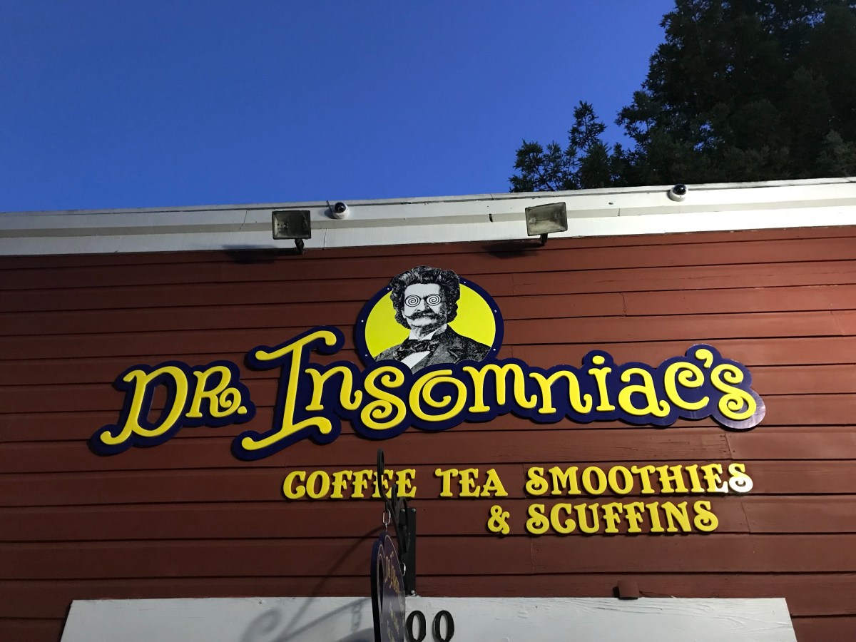
Dr. Insomniac is a devious tyrant. Had we not stopped for his elixirs, then we would have seen the golden warbler.

More birders arrived every minute and the lot was full. We stayed on the narrow ridge, which provided eye level views of the willows while other birders headed to the beach or went into the “cave”, a muddy track under the willows. With so many eyes, someone was bound to see the golden-winged warbler again. The question was, would we be able to get to the right location in time to see the notoriously sulky bird. We took our chances and took a wait and see approach and hoped the bird would come to us!

An hour and a half later our wait paid off. Dickcissel spotted the wayward warbler off to our left. I soon had my binos on the bird, bold, chickadee-like facial pattern, yellow mohawk, and yellow wing bar. The warbler was foraging under the canopy with a flock of white-crowned sparrows. We were able to observe the bird for a few minutes before the warbler dropped down and out of sight.

I quickly became aware that our narrow ridge had become a very crowded place. A woman to my right was thrusting her elbow into my side as she tried to get a view of where the bird was just seen and a man standing behind me was huffing and puffing into my right ear, his warm, coffee tinged breath gave me the willies! We were surrounded by rabid birders who were manically trying to add this west coast rarity to their life lists. This seemed like the worst rush hour subway ride imaginable! It was clear the bird had flown and after a celebratory fist bump, it was time to extract ourselves from the overcrowded ridge without falling to our deaths!

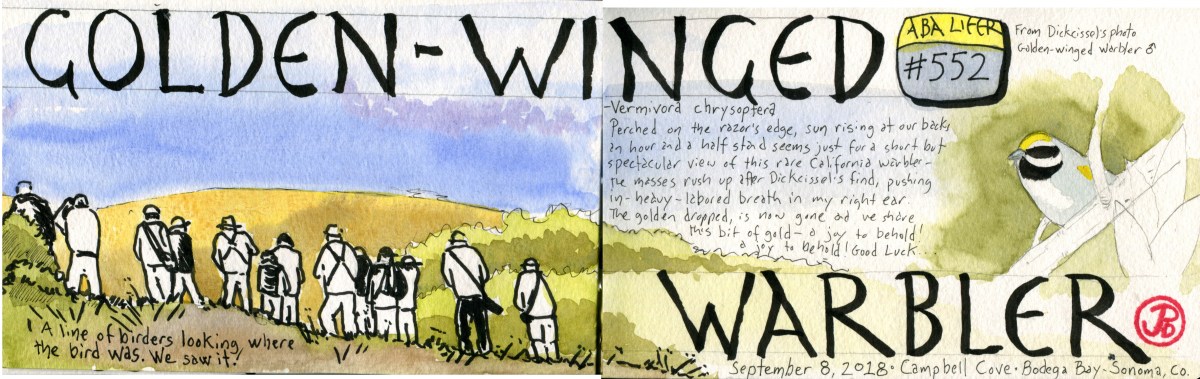
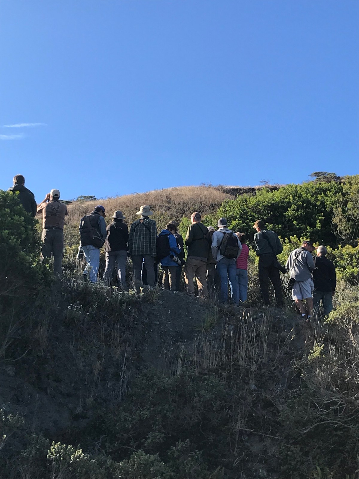
The maddening crowd on the ridge looking into the willows where the golden-winged warbler used to be.

Image

Half Moon Bay Pelagic Birding

To the outside eye, birding makes a man do some crazy things. The list is too long to retell here and to be honest I have conveniently forgotten a few.

So what do I do on my first Saturday after my first week back at school. Relax? Of course not! I wake up at 5:30 AM, drive 30 minutes through pea soup thick, Pacifica fog and stop to caffeinated at the Press Cafe, where all the fisherman of Pillar Point Harbor do the same (they open at 4 AM daily).

I then stood at the base of the Johnson Pier, coffee in hand and my binoculars around my neck, wearing them as a lanyard at a conference, announcing my place in the world. Other birders slowly wandered in to form in loose flocks, some nibbling ginger cookies other talking about recent avian sighting.

Our destination was the pelagic birding grounds of San Mateo County and we would be heading out to the Continental shelf aboard the New Captain Pete, a 53 foot fishing charter boat. But we would be doing no fishing on this all day trip.

Sunrise over Pillar Point breakwater as the New Captain Pete heads out to the Pelagic birding grounds of San Mateo County.

We headed out from the harbor it was interesting to see the groups of birds we were seeing as we were heading out to the pelagic or open ocean birding grounds. We first where seeing coastal species such as brown pelican, Caspian tern, and Brandt’s cormorant. A little further out we started seeing marine species that can be seen from land but with a scope. Common murre, a parent with begging young in tow, a pair of marbled murrelets, and a few Heerman’s gulls on the water. At the edge of this zone we spotted our first northern fulmar.

My pelagic map (from Pillar Point Harbor).

As we headed closer to the Continental shelf we became to see more pelagic species that are rarely seen from land such as Buller’s and pink-footed shearwaters, pomarine and long-tailed jaegers, and the long haul migrant, the arctic tern.

As we approached the shelf we spotted a giant of a bird, sitting on the water. This was the master of the wind, the black-footed albatross, a west coast speciality. These birds are amazing to watch on the wing and there can be very tame, often approaching boats.

Once we hit the weather buoy on the Continental shelf, we seem to be seeing more shearwaters and were surrounded by Pacific white-sided dolphins that road the bow wake and paralleled our path. On this journey we also spotted about 40 humpback whales.

Over all it was amazing day at sea, with calm seas, many pelagic bird species and marine mammals.

I highly recommend going with Alvaro’s Adventures on a pelagic trip to the Continental shelf.