Image

Rocks of JT

On the first part of the journey
I was looking at all the life
There were plants and birds and rocks and things
There was sand and hills and rings


                                                      A Horse With No Name

                                                      America

I was in the high desert of Joshua Tree National Park for the plants and birds and rocks and yes even the things.

I always enjoyed sketching sculpture and architecture because unlike animals, they ain’t going anywhere soon. The rock formations of JT are nature’s sculptures and sketching them is a desert meditation where you lose yourself in the lines and contours of weathered rock and at the end of the sketch you come away understanding that rock just a little bit more.

On my second visit to Joshua Tree in two years, I focused much of my sketching time on rocks, some famous like Arch Rock and Skull Rock but others that bear no known name. I named these rocks such as Repose Rock (above) but I’m sure other visitors have given it other names. Jelly Bean Rock seems like a likely canidate.

Skull Rock is probably one of the most visited sights in JT. I suspect one reason is that the rock bears an uncanny resemblance to a human skull, the other is that is about 20 feet off the main road and does not require a hike or even a brisk walk to see it.

Here is a self-named rock that I sketched in the popular rock climbing destination called Hall of Horrors. This I call Balanced Rock and in the sketch I also included some of the plants and some of the “things” but no “rings”.

Image

2018 Holiday Linocut Print

This year I was up to my ears in report cards and conferences and I have little fuel in the tank to create my annual holiday linocut prints. But once I started to sketch out designs for this year’s print, my artistic batteries started to recharge.

Two of my previous snowman prints at my mother’s house. The one above is from 2007 and the print below is from eight years later. I have definitely improved my technique and understanding of the medium.

Since 2007 I stopped buying things for family and friends and I started to create an annual  holiday snowman print instead. This seemed to me to be in the true spirit of Christmas gift giving. You weren’t going to find me queuing in front of a big box store on Black Friday at an unGodly hour, ready to stimulate our consumer-rich economy! I pulled out a sketch book instead!

Snowtree sketch

I thought that I wanted a snowman standing in front of a conifer. I first conceived the design as being symmetrical with the silhouetted tree and snowman in alignment. Adding a scarf  was going to throw off the symmetry but I can’t resist a flowing, wind-blown scarf!

After I had decided on a final design, it was now time to carve the imagine into linoleum. You never get a true sense of what the print will look like until you charge the block and make your first test print.

IMG_0184

Printing is not always a very a pretty process. I use oil-based ink because I hand tint the prints with watercolor. This is very messy and I only want to do it once so my print run was 20 prints.

Happy Holiday to all and a Happy New Year!

Image

Field Sketching: FC Shell Bar

One part of journaling that I can improve on is field sketching. When your subject is a landscape or a piece of architecture then field sketching is a little easier. But when sketching a live, wild animal, then you’re dealing with a beast of another nature!

On a recent Saturday I headed out to the Foster City Shell Bar to do some field sketching. No I was not sketching techies drinking mamosas during brunch, the Shell Bar is a piece of exposed tidal flats along the San Francisco Bay. The Shell Bar is also a hotspot for shorebirds, terns, and gulls.

The benefit of sketching at the Shell Bar is that this is where the shorebirds come to rest, making them easier to sketch as they pose in repose. One of my target birds to draw were resting black skimmers, these terns with huge elongated lower mandibles are a specialty for this location. When we arrived there were 50 individuals to sketch from.

Scope view of the Shell Bar with resting black skimmers in the background.

There are many benefits when sketching a resting bird. One of the first benefits is that the bird is still and is not flying around making them much easier to capture in the pages of a sketchbook. Also most shorebirds at rest, tuck their bills in to their back feathers for warmth, making it easier to sketch because you don’t have to worry about bill length and shape (the black skimmers have one of the more complex and odd bills on the Shell Bar). And another benefit is that most birds when at rest on the shell bar are standing on one leg, simplifying your avian subject even further. It’s easier to draw one leg instead of two! This is especially true of the hundreds of willets resting on the flats.

With me at the Shell Bar, with sketchbook and binoculars, was my birding-skeching acolyte, whom I shall call young Grasshopper Sparrow.

He once referred to an upcoming Disney Cruise to Mexico as, “a five day pelagic instead of a cruise. ” This young birder has his priorities in the right place! He plans to spend his time on the foredeck looking for boobies and tropicbirds. Young Grasshopper is a quick learner!

Forster’s tern at rest.

We both sat on the shell bar and sketched the resting terns until the tide slowly covered the flats and the birds dispersed, heading out either north or south from our position.

Every good tern deserves another. Two adult black skimmers and Forster’s tern in the back ground.

One-legged red knots, willets, and a marbled godwit in the background with a ruddy turnstone turning stones in the foreground.

Old Tomcat

One of the best things about birding has nothing to do with birds but having unexpected experiences and visiting places that you would have never visiting if you were not trying to add a few birds to your lifelist.

To escape the smoke of the deadly Camp Fire up north I headed south to my cabin retreat in Santa Cruz. The air quality was so bad in the Bay Area that school was cancelled on Friday. To avoid cabin fever, I headed to the UC Santa Cruz campus to bird the arboretum. There were many birds and I tallied 28 species. But what was the most revelatory was an intimate encounter with a furry four legged old cat that catches and devours birds.

As I was heading to the back of the arboretum I paused to watch the Anna’s hummingbirds jostling for territory in the Australian section. To my right, some movement caught my attention. It was a cat drinking at a water feature in the garden. It was a male bobcat and he seemed to not be one bit concerned with how close I was. From about 15 feet away I observed the cat as he took a long drink and then headed down the path to take a cat bath.

The tomcat groomed for ten minutes, allowing me great views in excellent light.

The cat reminded me of when I was an educator at Coyote Point Museum and I worked with their non releasable raptors. If a bird preened itself while it was on the glove then you knew the hawk, falcon, or owl was truly relaxed. Well the great horned owl was never very relaxed.

This male bobcat that gave himself a deep cleaning right in front of me was truly relaxed and acted as if I was a present but benign tree. A perfect disguise for observation.

I was able to photograph the bob and I included a few of the photos.

Image

Alder Creek Donner Camp

Perhaps no family suffered more during the horrors of the winter of 1846-47 than the Donner family. The Donner Party was made up of many families, trying to make it to California’s bountiful Central Valley.

George Donner was elected the leader of the party, and now the party, lake and pass now bears his name. Seven members out of 25 of the Donner clan perished in that winter of record breaking snowfall. But they did not camp with the others on the eastern shore of Truckee Lake (now Donner Lake) but because of a broken wagon axel, they stopped for the winter in the Alder Creek Valley, six miles from the lake that now bears their name.

The site of the Donner Camp with a tree that was later planted by the Donner survivors.

The list of those who survived and those who perished at the Alder Creek camp site.

The area now is peaceful and if it wasn’t for the signs on the interpretive loop trail, you would never know of the horrors that the Donner family suffered in the winter of 1846-47 with he record amount of snowfall that winter. There is very loyal evidence of the camp. Tree stumps that were visible at the beginning of the 20th century are all gone.

An interpretive sign at the start of the trail with the ominous title, “The Nightmare Begins”.

In a pioneer group infamously known for it’s cannibalism, there is a deep sense of irony that the location of the doomed Donner camp at Alder Creek is now know as the Donner Party Picnic Area.

Happy Thanksgiving!

The Pioneer Monument on the eastern side of Donner Lake.

Image

Sierra Valley-The End of the Road

The final stretch of my Highway 49 road trip was by far, the most scenic of the entire highway. The last 109 miles, from Grass Valley to where 49 ends at junction with Highway 70 at Vinton, takes you to higher elevations than at any other part of the highway and the highlight was Sierra Valley.

At about 5,000 feet above sea level, Sierra Valley is a broad, flat valley, rimmed by low mountains. When driving this lone stretch of 49, you are more likely to encounter cows than other people. This is a stretch of 49 that encourages reflection and peacefulness. They are a few towns along the way: Sattley (Population 49), Sierraville (Population 200), and the jumping metropolis Loyalton (population 695).

Population: 49 on Highway 49. I wonder how often this coincidence takes place?

Where as the first part of 49 from Nevada City was television, hemmed in with trees and cliffs, entering the Sierra Valley was like watching a wide screen western epic. I was passing through a John Ford film, without the monuments of Monument Valley but the wide open spaces that are not always easy to find in California. It’s a type of landscape that would make Bing and the Andrew Sisters croon, “Give me land, lots of land with the starry skies above, don’t fence me in”.

I finally found “my” creek!

The benefit of being in Sierra Valley in October is that wintering raptors are starting to take up their winter quarters. I started to notice an uptick in red-tail hawk numbers, perched on the power poles. This is a very common hawk in the west but their numbers were a little uncommon.

Then I saw a large pale hawk off to the left. Now this was a true winter visitor to the valley. This was our largest buteo ( broad wing hawk), the ferruginous hawk. Buteo regalis! I pulled over and grabbed by car binos. Above one wide cow pasture there were three ferruginous hawks in my field of vision! The most I had seen in the sky at one time.

Here’s where Highway 49 begins in Vinton and it’s where I turned around and headed south for the first time on my road trip.

Once I had driven to the highway’s end at Vinton (Population 0) I headed back south and I stopped to photograph a highway sign with the scenic background of Sierra Valley. I looked up at the power pole and there I saw another wintering raptor perched on the cross arm: a prairie falcon.

Who doesn’t love Cowboy poetry?

Image

The Kennedy Mine

The popular image of a Forty-niner era goldminer is of a bearded man in a flop hat, a checkered shirt and suspenders, and jack boots. In tow was his “mountain canary” or burro and strapped to the burro was his spade and gold pan. He might have a piece of mining equipment call a rocker. Perhaps this was the image of a miner in 1849. But mining in the Gold Country continued up until World War II and at a much larger scale.

In the town of Jackson is a perfect example of a large scale mining operation that operated halfway into the 20th century. The towering headframe of the Kennedy Mine can be seen from Highway 49. I had seen this many times on my way to the Eastern Sierras but I was in Jackson on a Saturday when the Kennedy Mines were open to the public and this was the final Saturday of 2018 that the site would be opened. This would be the first time that I would be able be see this massive mining operation up close!

The Kennedy Mine is known to have the deepest mine shaft in the United States at the time of its closing. The shaft reached 5,912 feet down into the earth. The area was first mined in 1860 by Andrew Kennedy who later sold his share in the mine and the following year and the Kennedy Mining Company was formed. Many improvements and changes happen in the intervening years. The mine was closed in 1942 by the US government because of the war effort. After the war, gold mines could be reopened but the shafts and tunnels of Kennedy Mine were flooded with water so the company chose to keep the mine closed. At the time of its closing the miner had produces $28,000,000 worth of gold.

The center piece of the mine is 135 foot high East Shaft head frame which is the tallest headframe that is still in existence. It acts like a beacon that can be clearly seen from Highway 49 when heading down the hill to downtown Jackson.

Image

Chaw’ se

On the fourth day of my Highway 49 road trip I headed off the highway to night in the historic town of Volcano in the equally historic three story hotel the St. George. One of the reasons I headed off the highway was to visit Indian Grinding Rock State Park or Chaw-se as the native Miwok call it.

I had seen chaw’se or grinding rocks at Coloma before. These mortars which were grinded into stone were used by native peoples to grind acorns into a fine powder. Each depression took generations to create. Each hole could take over a century of work.

I was now looking over the largest concentrations of grinding rocks in North America. There are 1,185 mortar holes in this State Park.

I walked over to the ceremonial roundhouse, which is still in use by the native people of California. I sketched the structure along with the life-giving valley oak.

The roundhouse was the center of Miwok life and this roundhouse was constructed in 1974.

On my way out I sketched thew beautifully rusted stature of a Miwok dance by J. L. Plamondon which is: “Dedicated to the First People of California”.

Image

Calaveras Big Trees

No other Giant Sequoia grove illustrates the worst and the best of humanity as Calaveras Big Trees State Park.

I’ve visited other sequoia groves in the Sierras but this was my first visit to the epicenter of this iconic, Californian tree that captured the world’s attention.

The story goes that in 1853, Augustus T. Dowd was tracking a wounded grizzly bear that eventually led him to a massive tree that was over 1,000 years old, the likes of which had never been seen by white European settles before. Of course the native Miwok had known about the sequoias for centuries.

Dowd returned to his camp near Murphys and told all that would listen about his “discovery “. Few believed him so he offered to take a party of nonbelievers to the massive tree, to see for themselves.

The tree that Dowd showed to the party he brought with him is now known as the Discovery Tree. The following year demonstrates man at his worst when five men took 22 days to cut the tree down. No saw was large enough to cut through the massive truck so they drilled hundreds of holes through the tree with pump augers until it eventually fell. The evidence of the destruction is still visible today in the large section of the tree know as the Chip of the Old Block.

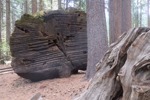
The holes drilled in 1854 to take down the Discovery Tree by an auger pump drill are plainly visible today. The Big Stump is visible on the right handed of the picture.

A two foot thick cross section of the giant trunk was cut and along with sections of bark, was sent to San Francisco to be displayed for profit. After being displayed for two months, what was now billed as “The Giant Tree” was packed up and shipped around Cape Horn to be displayed in New York City. The remains of the tree was eventually destroyed in a fire, in 1855. Prompting William Tweed to write in his book King Sequoia, “We can only wonder whether anyone noticed the irony that a tree that had endured for more that 2,000 years in the wild ended up as a commercial exhibit that lasted barely two years.”

This stump that remained in the grove was planned and used as a dance floor prompting John Muir to write, “The vandals then danced upon the stump!” The fallen length of the Discovery Tree was used as a double lane bowling alley and a bar.

Humans finally came to their senses and the grove eventually became protected as a State Park in 1931.

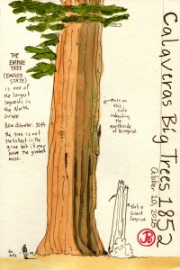
After sketching the Big Stump and Chip Off the Old Block, I continued on the North Grove Loop Trail which provided a great understanding of the natural history of these incredible giants. I stopped to sketch the Empire State Tree.

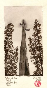
Further along the loop trail was one of the most striking examples of humans abusing and exploiting the giant sequoia for profit when I saw what remains of the Mother of the Forest tree. It is now a huge, scared and burned snag. In 1884, scaffolding was build around the tree and rose up to 116 feet. The tree was stripped of its bark and the bark was shipped to be reassembled and displayed in places like New York and London. John Muir remarked, “Skinning this tree alive is as sensible a scheme as skinning our great men would be to prove their greatness.” Without its protective bark the tree was severely burned in the fires of 1908. We can only hope that we learned that it is far better to protect these giants than it is to destroy them.

The good is humanity persevered this sequoia grove which still fills modern visitors with awe. Even though I have been to other sequoia groves in the Sierras, the North Grove at Calaveras Big Trees State Park, filled me with reverence for this incredible tree that captured the world’s attention.

Image

BoomTown to Ghost Town

The Gold Rush was a time of boom and bust. Many towns first started as miner’s camps composed of canvas tents centered around a mining area. Perhaps tents were replaced by more permeant structures made of wood. In most miner towns there inevitably was a fire which destroyed all or part of these mining towns. When the towns were rebuilt, the structures were built of brick and it is these structures that are around today, either as a still functioning structures or as a Gold Rush ruin.

Many of the towns that I drove through on Highway 49, tell of this boom and bust. Some towns would have populations of 3,000 or 5,000 people at their height and then the diggings would be mined out and the town’s population would disappear to the next new gold discovery site. No two towns exemplify this today more than the prosperous town of Columbia and the virtual ghost town of Hornitos.

Gold was discovered in the area around Columbia on March 27, 1850. Columbia became a boomtown with its population swelling to 5,000 with 150 saloons to quench the thirst of parched miners. Over that time $150 million worth of gold was mined from the hills surrounding the town becoming one of the most prosperous areas in California’s Gold Country. At one time, Columbia was the second largest city in California and was once considered for the site of the state capital.

The centerpiece of Columbia State Historic Park, the 1858 Wells Fargo & Company building. More than 1.4 million ounces of gold was weighted out in this building.

By the 1860’s, most of the gold had been mined out and the population decreased. But Columbia never became a ghost town. The two story brick schoolhouse (built in 1860), which was used up until 1937, speaks to the vibrancy of the town that never gave up the ghost.

In 1945 the state bought the land and preserved the site of the historic downtown as Columbia State Historic Park. It now represents the largest collection of Gold Rush era buildings in existence. Walking down Main Street is to take a step back in time.

During the Gold Rush, Hornitos was known as one of the roughest and toughest towns among the southern mines. The outlaw Juaquin Murrietta is reputed to have used Hornitos as a hideout. The town predates California’s Gold Rush and was founded by Mexicans who were kicked out of nearby Quartzburg. During its height it is said that Hornitos had a population of 15,000 and was the only incorporated town in Mariposa County.

Now Hornitos is a backwater, 13 miles from Highway 49 in what seems like the middle of nowhere. The town, well really settlement might be a better name for it, now has a population of about 60 souls. But as I walked the street of “downtown” Hornitos, the only sign of life were the cows in the far fields and 80’s pop music blaring from a house that looked it had been abandoned back it the late 80’s. At least they have electricity in Hornitos.

I was standing in front of the building that had drawn me away from Highway 49 to this small town. The red brick building is now just a hollow shell of its former self, a ruins of a former business started by an Italian immigrant. His name was Domenico Ghirardelli and it was in this brick building that his chocolate empire began. Here in Hornitos, Ghirardelli ran a general goods store from 1855-1858 and he sold the store and headed to San Francisco to start his chocolate business.

This ruins is a reminder that the people who made money during the Gold Rush were not always mining for gold, they were mining the miners.