Image

The Road to Sesame Street Runs Through Salinas?

The two shows and film from my childhood that brings back happy memories are: Sesame Street, The Muppet Show, and The Muppet Movie. All three were the brainchild of puppeteer Jim Henson.

Henson had worked on Sesame Street but wanted to expanded towards a variety show for children and adults. American television was not interested in his new vision but they were in Britain. The Muppet Show became a huge international success and Henson wanted to take the Muppets to the big screen. This became the Muppet Movie (1979). For the film, Henson wanted to take the Muppets out of the studio and into real filming locations. And one of those locations was a mere 50 minute drive from my cabin in Santa Cruz.

That’s where my Muppet sketching quest begins!

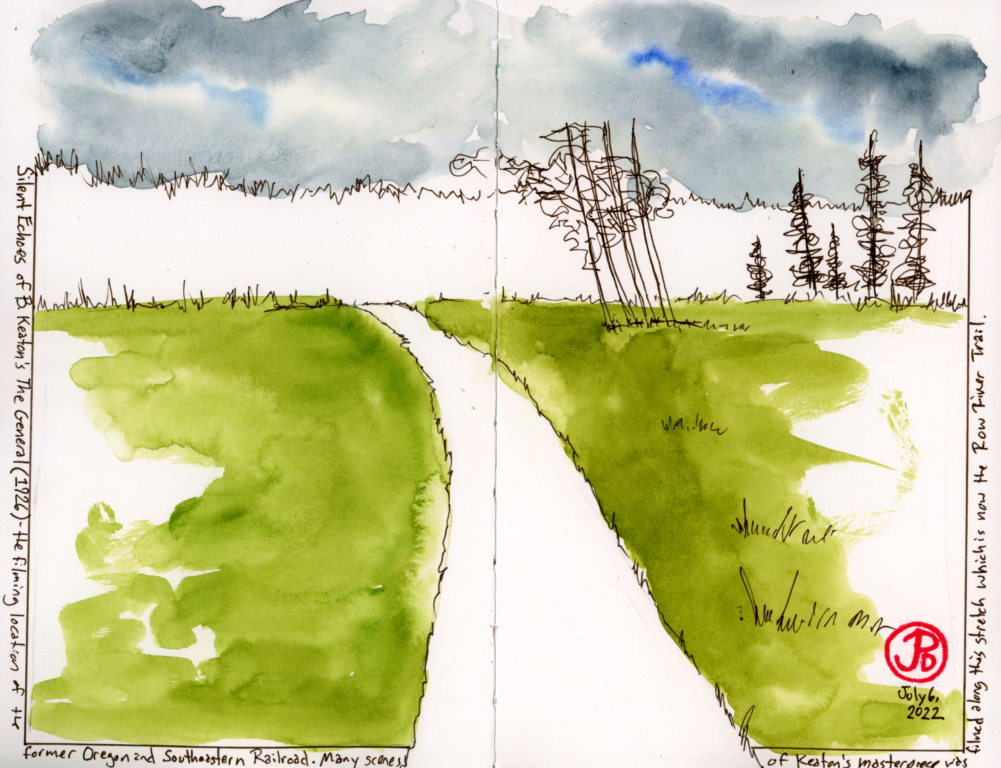
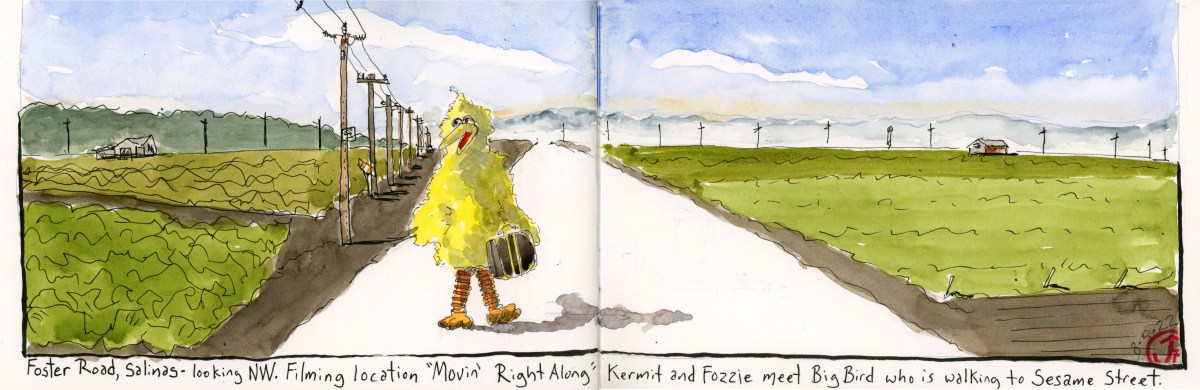
And so it was that I headed south and then east towards the city of Salinas in Monterey County. South of Downtown Salinas, between Highway 68 and South Davis Road is the rural farming road, Foster Road.

Kermit the Frog from the Jim Henson exhibit at the Contemporary Jewish Museum in San Francisco.

This is the setting of one of the more memorable scenes in the film and it occurs during the song “Movin’ Right Along” where Kermit and his new friend Fozzie Bear are driving to Hollywood to become famous in Fozzie’s Studebaker.

Kermit and Fozzie are performed and voiced by long time collaborators Henson (Kermit) and Frank Oz (Fozzie). They are probably best known in Sesame Street as Bert and Ernie. Frank Oz was also the performer and voice of Yoda.

Kermit and Fozzie drive down a road, framed by farm fields and they come upon a large yellow bird walking the other direction with a suitcase. Fozzie asks, “Hey there, want a lift?” And Big Bird replies, “Oh no thanks. I’m on my way to New York City to try and break into Public Television.” Fozzie say, “Ahhh. . .good luck!”

Big Bird was performed by Caroll Spinney and it was great to see all three puppeteers in one scene: Henson, Oz, and Spinney.

Foster Road, Salinas, California, the filming location of Kermit and Fozzie meet Big Bird in The Muppet Movie.

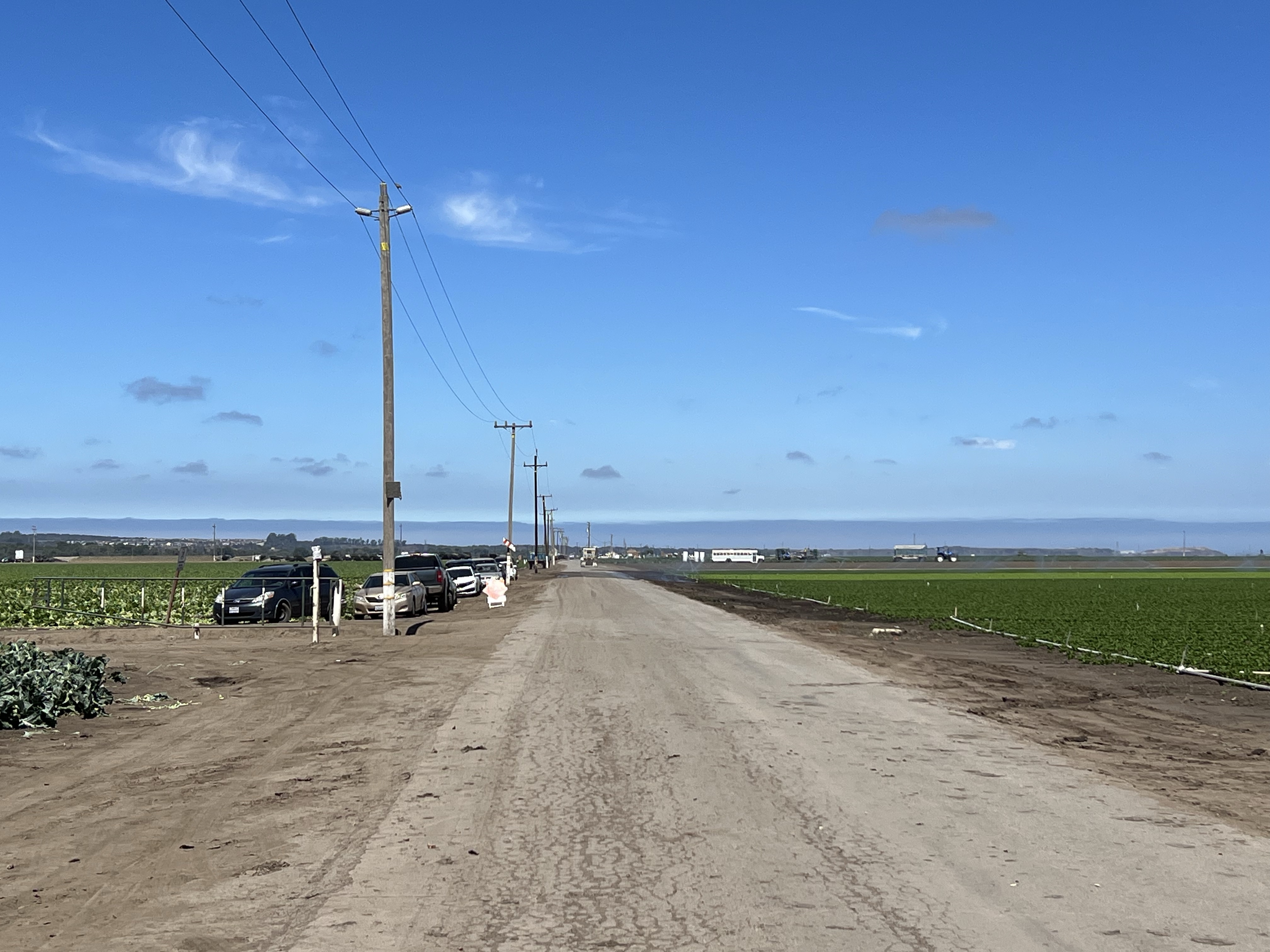
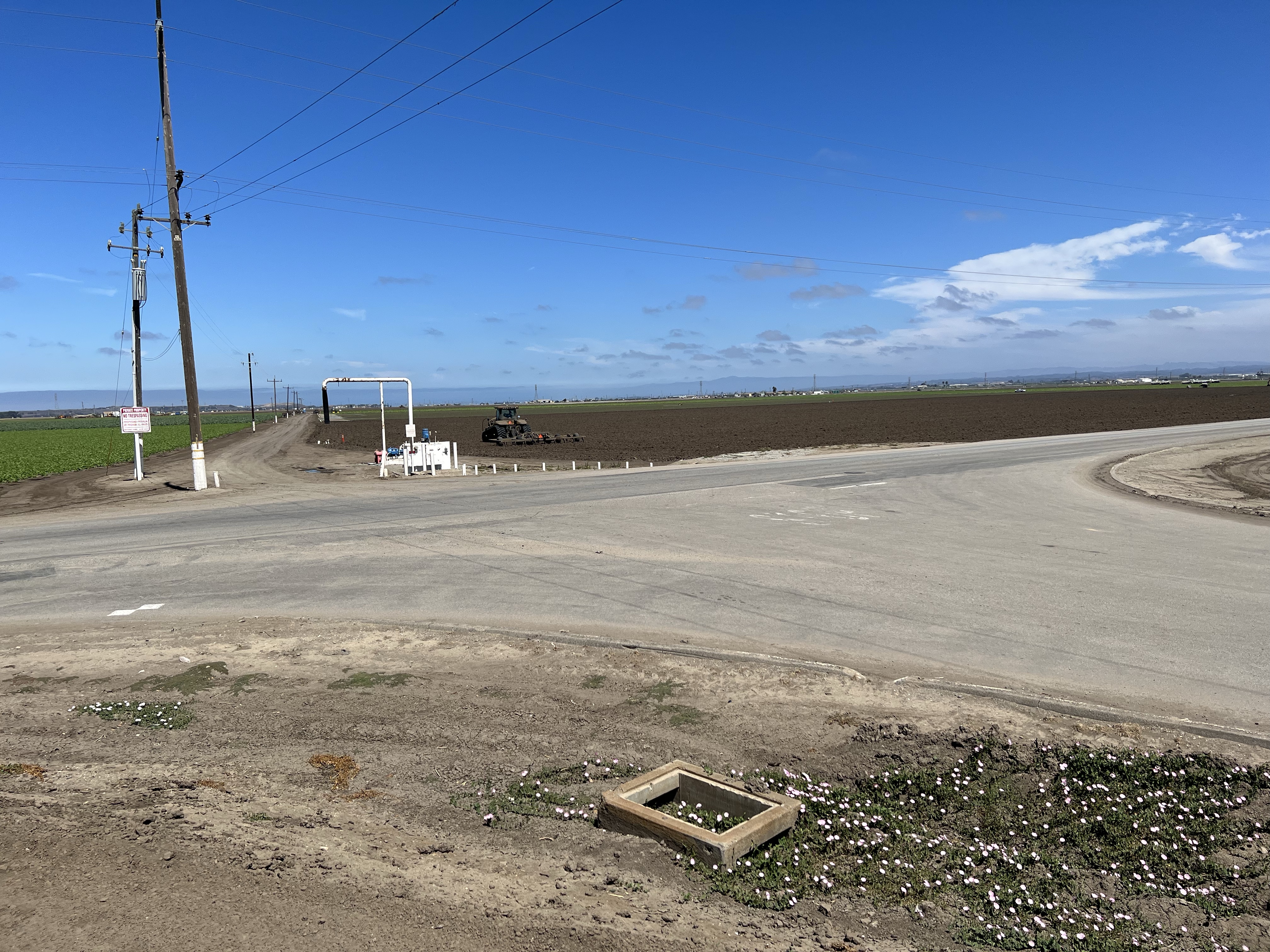
At the intersection of Foster Road and South Davis Road, is the location of the scene when the Studebaker drives in circles, filmed from a helicopter above, as Fozzie sings, “California here we come/ the pie-in-the-sky-land”. Of course the irony is that they are already in California, Salinas, California. Which is 300 miles north of Hollywood.

Image

McCloud River Railroad Number 25

Out on the coast of Oregon, north of Tillamook, is a 97 year old screen queen that is still riding the steel rails.

On the northern edge of Tillamook Bay, in the town of Garibaldi, is the Oregon Coast Scenic Railroad . This is a tourist railroad that runs from Garibaldi to Rockaway Beach on former Southern Pacific rail.

The railroad has two steam and three diesel locomotives to pull the trains of tourists up and down the coast.

Morning sketch of one of the diesels of the Oregon Coast Scenic Railroad, the Great Northern EMD F7 Number 274.

In present day, the workhorse of the railroad is the Prairie style 2-6-2 steam locomotive McCloud River Railroad No. 25.

This locomotive was the last steam locomotive that the McCloud River Railroad purchased new. It was a workhorse for the lumber railroad and was featured in films most notably in Hal Ashby’s biopic of Woody Guthrie Bound For Glory (1976) and Rob Reiner’s Stand By Me (1986). In Stand By Me, Number 25 was featured in the famous train dodge scene that was filmed on the Lake Britton Bridge on the Burney Branch of the McCloud River Railroad. At the time of filming, Number 25 was on home rail.

The Lake Britton Bridge, filming of the ultimate train dodge scene in Stand By Me (1985).

Number 25 came to the Oregon Coast in July 2011 and has since headed tourist trains up and down the coast.

No. 25 having her tender filled with water, from a street fire hydrant, after a days work at Garibaldi.
The front end of 25 showing the builder’s plate.
Close up of the Builder’s Plate: Number 25 was build in by ALCO in Schenectady, New York in 1925.
Image

The Johnston Ridge Observatory

Most visitors who want to get close to Mount St. Helens, drive the 48 miles on the Spirit Lake Highway to the Johnston Ridge Observatory.

Here you are a mere 5.5 miles from an active volcano. This is well within the former Red Zone which was restricted to visitors in the winter and spring of 1980. Only certain people where allowed into the Red Zone and one of those was David Johnston, a volcanologist, who was there to monitor the volcano.

Johnston was really not supposed to be there the morning of May 18 but out of kindness he switched shifts with a colleague who was busy meeting with some foreign graduate students.

At the time of the eruption, Johnston was 30 years old and he had been working as an volcanologist who specialized in the study of volcanic gases and how these gases might help in the prediction of volcanic eruptions. He was at Mount St. Helens as one of the many scientists that were here to help monitor the volcano and to carefully watch the bulge on the north side of the mountain that was growing by five feet a day.

On Saturday May 17, Johnston stationed himself outside a USGS RV at a location called Coldwater II, 5.5 miles from the volcano. On the following morning Johnston made some measurements and observations and then at 8:32 AM, he radioed the USGS headquarters in Vancouver, Washington: “Vancouver, Vancouver, this is it!”

This field sketch is from the approximate position of Coldwater II, the observation position of David Johnston on May 18, 1980.

This was the last radio transmission from Johnston.

At 8:32 AM there was a 5.1 magnitude earthquake under the volcano causing the north face to fall away from the mountain causing the largest landslide in recorded geologic history. The avalanche travelled 14 miles before coming to a rest. This uncovered the over-pressured core of the volcano, releasing ash, magma, and rocks, fifteen miles into the atmosphere. The eruption of Mount St. Helens was now underway.

Johnston’s body was never found. The ridge where he was on that fateful day in 1980 is now named after him.

The memorial to the 57 who lost their lives and it’s cause in the background. David A. Johnston is one of them. The memorial is a short hike from the Johnston Ridge Observatory and it is this viewpoint that is in the featured sketch.
The incredible vista of Mount St. Helens from the Johnston Ridge Observatory.
Image

The Spruce Goose

When we think of an eccentric billionaire we tend to think of Elon Musk, but for decades before, the poster child for the archetype was Howard Hughes.

Musk and Hughes both shared an interest in aviation and exploration, and both went big. Hughes went really big.

I deviated off Highway 5 to see one of Hughes’ biggest follies. I was traveling to the town of McMinnville, Oregon (pop. 34,000), while it is only about an hour from Portland, the town seemed to be in the middle of nowhere and an unlikely location for housing the largest seaplane in the world.

This seaplane, coined the “Spruce Goose” (a nickname that Hughes always hated), is now housed in the Evergreen Aviation & Space Museum. It was nicknamed the Spruce Goose because it is the largest wooden airplane ever built. It also was given the moniker, The Flying Lumberyard, a name I think Hughes also hated.

The massive seaplane was designed during World War II as a cargo plane to ship goods across the Atlantic Ocean while avoiding the attention of German U-boats. The Spruce Goose only flew once, on November 2, 1947 in Long Beach, California. The plane was only airborne at a maximum height of 70 feet for 26 seconds. By the time of this test fight, the war was over and the plane was no longer needed.

The plane went into storage and was keep in pristine condition by a crew of 300 that were on Hughes’ payroll. They were sworn to secrecy and the aircraft was kept in flying condition but the Spruce Goose never flew again. In 1962, the crew was reduced to a fraction of it’s size and then was disbanded on Hughes death in 1976.

For many years the Spruce Goose (officially known as the Hughes H-4 Hercules) was displayed in a dome called the Spruce Goose Dome in Long Beach, California from 1980 to 1992. The new owners of the dome (a small company named Disney) felt that the oversized airplane was not making them enough money so a search was made for a new home for the massive airplane.

The new home was found in Oregon and the Spruce Goose was disassembled and shipped by barge, train, and truck and after a 138 day and 1,055 mile journey, the longest distance the H-4 ever travelled, the Goose arrived in McMinnville, Oregon.

The Spruce Goose is so massive that the museum was built around the plane and it upstages all the other aircraft on display beneath it’s massive wings. Sketching the H-4 proved to be a real challenge because you cannot get far enough away from the plane to capture it in it’s entirety. So I had to sketch it in pieces: the front (featured sketch) and the tail.

I could barely get three of the eight engines into one photo of the Spruce Goose. This airplane is massive!

Image

The Panorama From Windy Ridge

Perhaps the best view of Mount St. Helens, takes the longest drive, but the payoff is worth it.

This is Windy Ridge, five miles from the crater of Mount St. Helens. From the viewpoint you can see the U shaped peak of the volcano to the left and Sprit Lake to the right. Everything before you was part of the devastation zone.

All these year later the Pumice Plain still looks like a moonscape and Spirit Lake still has a raft of fallen logs that travels around the lake with the wind.

The matte of logs, looking here like toothpicks, from the 1980 eruption at Spirit Lake.

To capture this expansive panorama took four pages in my panoramic journal. In the field, I sketched in the forms of the landscapes with a sepia brush pen.

Mount St. Helens from Windy Ridge.
Image

Sasquatch and Mount St. Helens

Pre-1980, pre-eruptions, it seems that Sasquatch or Big Foot, was a tourist cottage industry around the slopes of Mount St. Helens.

Many a story was told around campfires on the shores of Spirit Lake about the time a creature attacked five miners near Ape Cave in the 1920s and how the miners valiantly had fought off the beast’s attacks.

What really kickstarted the Sasquatch craze was film footage reportedly of a female Sasquatch or Bigfoot walking along Bluff Creek in Northern California. The 1967 film is now known as the Patterson-Gimlin film and iconic, Frame 352, shows the creature looking back towards the camera with arms extended away from it’s dark hairy body in it’s simian lope. The famous imagine, included in the featured sketch, is the blueprint for many subsequent representations of Sasquatch. This is the iconic “Big Foot” imagine that is recognized around the world much like the Surgeon’s photo of the Loch Ness Monster. Both images have been claimed to have been faked, but there are those who will always believe.

Of course that all changed after the May 18, 1980 eruption of Mount St. Helens where seeing a live volcano was a major draw for the tourist dollar and poor Sasquatch receded into the past. More volcano tourist attractions and museums appeared around the mountain, selling tourist trinkets with imagines with erupting volcanoes, pushed Sasquatch swag off the shelves.

This cartoon, printed in the Columbian in 1980, highlights the conflict between Sasquatch and the now famous volcano.

One such tourist attraction is to be found along the Spirit Lake Highway near Kid Valley. This is the North Fork Survivors Bigfoot & Mt. St. Helens Interpretive Center. The attraction sits across the highway from the Toutle River. This has it all for the Mount St. Helens/ Sasquatch fan.

When the volcano erupted it sent mud and melted waters from glaciers and the snowpack racing down the North Fork of the Toutle River, which destroyed everything in it’s path: forest, bridges, and homes. One home that survived is the A-frame house that was half buried by the mud flow. The house is left as it was on May 18, 1980, still furnished but now filled with 200 tons of ash, mud, and silt. You used to be able to explore the interior but it has now been deemed unsafe and is now a nesting site for barn swallows.

On the other side of the parking lot is the 20 foot statue of Sasquatch, leaning on a branch for support, like someone at a wedding, who has had a tad too much to drink. This is what attracted my sketching eye and I began to render the statue in pencil and ink.

The butt-end view of the Sasquatch statue at North Fork Survivors Bigfoot & Mt. St. Helens Interpretive Center.
It’s all about Sasquatch around Mount St. Helens. This is a road I found on the south side of the mountain on my way to Windy Ridge. I had to pull over and take a photo.

Image

Zephyr Sketching (Westbound) Part 2

I really wish I could sleep on a train. Once we entered Utah, the Zephyr picked up speed and the train starts rocking and jolting even more.

It allowed me a little time to explore the AMTRAK stop at Salt Lake City. You would think that a city with a rich history that SLC would have an equally impressive station as Denver’s Union Station. The truth is that the City of Saints has not one impressive train station but two.

The current AMTRAK station is really a double wide trailer. But beyond the station, you can see the red neon sign of the former Rio Grande Station. The Union Pacific also had a separate station a short distance from the Rio Grande. While both buildings still exist, they are no longer passenger stations. The Rio Grande folded in 1987 and the UP no longer carries passengers.

I was looking forward to the stretch break at Reno because it provided enough of a break to get a sketch in (featured sketch). I sketched the Zephyr pointing west towards California as a east bound fright passes on the next track.

Here is a sketch I did last spring of the Zephyr at Reno during a stretch break.
Image

The Exploding Whale of Florence

One place I wanted to visit on the Oregon Coast is Florence. Why? It’s the setting of the exploding whale.

In 1970, an eight ton, 45 foot long, sperm whale washed ashore on South Jetty Beach near Florence. While this must have been a local attraction for a short time, the dead whale began to smell. And the stench began to turn heads. The breeze off the Pacific Ocean was blowing the stench of the rotting whale right into downtown Florence.

How do you get rid of an eight ton whale? Well the Oregon State Highway Division had an idea, a very optimistic idea for a very large problem.

First they had to discount other ideas. Burying the whale meant the constant wave action would expose the copse before too long. To tow it out to sea by boat would be costly in diesel fuel because you would have to tow the whale far enough out so it would not be returned again by the tides to South Jetty Beach. The whale could be cut up and then buried but that would require a very large chain saw and a lot of labor. So of course they went with the cheaper solution: dynamite.

In fact, half a ton of dynamite.

So on November 12, 1970, dynamite was placed under the whale with the intention that it would be blown into smithereens and what was left of the sperm whale would be taken care of by gulls and other scavengers.

Locals came out as if they where going out on an afternoon picnic to watch the spectacle. The dunes to the east of the whale provided a natural sloped amphitheater. Some spectators were a little too close and they where moved a quarter of a mile away from the dynamited corpse.

Then the countdown began and the dynamite was detonated sending sand and fire and whale bits, 100 feet into the air. What blows up, must come down and flaming whale parts began raining down on the spectators who were now where running for their lives. One large piece of sperm whale landed on a parked Oldsmobile, crushing it.

What was left of the whale, once the sand cleared? Well a whole lotta whale.

The Exploding Whale of Florence, Oregon has now become part of folklore. It is the type of story, when retold, the listener grows incredulous, doubting that this could really ever happen. But it did.

The town of Florence has embraced it’s erupted cetacean past. In 2019, the Exploding Whale Memorial Park was established along the northern tidal banks of the Siuslaw River.

The setting of the scene of the exploding whale still exists and I headed out to South Jetty Beach with my sketching chair and started to sketch the beach facing north (featured sketch). And parts of the eight ton sperm whale still exists in the the Siuslaw Pioneer Museum. In the museum, in a glass case, are bones, including vertebrae, of the failed dynamiting of the sperm whale. Included in the sketch is the whale’s vertebrae in the left side of the featured sketch before I headed out on my South Jetty Beach sketching adventure.

Image

Harry R. Truman

Soon after the earthquakes started in March of 1980, Harry Truman was urged to leave the lake and lodge he loved.

Harry R. Truman was born on October 30, 1896 in West Virginia. When he was a child, his family relocated to the state of Washington and settled in the eastern part of the state on 160 acres of farmland.

Harry first came to Spirit Lake in 1926. He then ran a shop and gas station that also rented boats. Over the years he built up Mount St. Helens Lodge which was on the shores of Spirit Lake and at the base Mount St. Helens. He ran his lodge for 52 years with the help of his third wife Edie.

Sprit Lake was a summer paradise, ringed with many camps, resorts, and lodges. Visitors enjoyed swimming, canoeing, and fishing on the cold waters and enjoyed stunning views of the mountain that loomed over the lake. Harry was looking forward to visitors for the upcoming summer season (being a curmudgeon, perhaps he was not so optimistic). But then the mountain started shaking.

Residents close to the mountain where evacuated but Harry refused to go. He had lost his wife five years previously and he had been wedded to the lake, the resort, and the mountain for fifty years. He was not going to leave.

Truman became a media darling and a folk hero. Many reporters where flown in to interview him. Truman often had his favorite drink in his hand, Coca-cola and Schenley whiskey. Harry once told a reporter that he hates to drink but people drive him to it. He also told another reporter, “If the mountain goes, I’m going with it. This area is heavily timbered, Sprit Lake is in between me and the mountain, and the mountain ain’t gonna hurt me.”

He could not have been more wrong. Just like the government officials, the press, and some members of the USGS who underestimated the incredible power of the sleeping giant that is Mount St. Helens. They certainly found out at 8:32 AM on May 18, 1980. But for Harry, he had little time to reassess his situation.

It has been estimated that Harry had about 22 seconds from when the landslide started to it’s arrival at his lodge. Harry must have heard and felt it coming but could do nothing to save his life.

He would become the first of the 57 causalities of the eruption of Mount St. Helens. And his body has never been found but is buried under 300 feet of the landslide that was the northern flank of Mount St. Helens. The mountain that Harry had loved and hiked upon now was his earthen grave.

This Roger Werth photograph of Truman sitting on the front steps of the Mount St. Helens Lodge was taken the day before the volcano erupted. The only thing missing from the photo is his cap and his drink.
Trumans name on the memorial to those that perished during the May 18, 1980 eruption of the mountain behind the memorial.

Image

Buster Keaton’s The General

For some time I wanted to visit the filming locations of Buster Keaton’s masterpiece The General, if any of locations still existed. (One location used in the film is now underwater!)

The film was made during the summer of 1926 in and near the town of Cottage Grove, Oregon. The forested backgrounds and the tracks of the Oregon, Pacific and Eastern Railroad made Cottage Grove an ideal filming location to fill in as Georgia during the Civil War.

But was there anything still recognizable? Probably not too much but with the help of the book Silent Echos: Early Hollywood Through the Films of Buster Keaton by John Bengston, I could find a few reminders of those days in the summer of 1926.

A pre-trip sketch of a scene filmed on the double tracks near downtown Cottage Grove. In the background of this shot is Hansen Butte, which is still very much recognizable today (see featured sketch).

The General has long been considered a masterpiece of the silent film era and one of Buster Keaton’s best. In the Sight And Sound list of The Greatest Movies of All Time, The General comes in at number 34, the highest ranked silent comedy on the list. Orson Welles (whose own masterpiece, Citizen Kane, comes in at Number 2) once described The General as, “the greatest comedy ever made, the greatest Civil War film ever made, and perhaps the greatest film ever made”. Now that’s saying something!

The film is loosely based on a real incident known as the Great Locomotive Chase which occurred during the Civil War on April 12, 1862 in northern Georgia. It involved the theft, by a northern raiding party, of the locomotive The General and the pursuit by the locomotive The Texas for about to 90 miles.

On Main Street is the Cottage Grove Hotel where Keaton and the crew stayed during the filming. This hotel can be seen from the filming location which is now the Row River Trail. The hotel now sports a mural.

Many of the train scenes were filmed on a pair of parallel double tracks that ran for about half a mile on the former Oregon, Pacific and Eastern Railroad. These tracks were appealing to the film crew because two trains could run parallel to each other, one train with the camera and crew, the other train, the subject of the shot and the actors (including Keaton). The tracks are now gone (the railroad was scrapped and removed in 1994), but you can now explore the former rail right of way by either foot or bike. The former railroad is now the Row River Trail.

The section with the double track runs behind a Safeway. While the area is completely changed since 1926, the hills in the background (Hansen Butte and Know Hill) are still the same (see featured sketch). I did walk down the path and did a sketch of the former filming location.

This is looking west down the former tracks of the Oregon, Pacific and Eastern Railroad used for filming The General.
Riding east on the Row River Trail, the filming location of many scenes in The General. The back of the Safeway is on the upper right. More about this cinematic bike ride in the next post! (No cyclists were injured in the taking of this photograph).