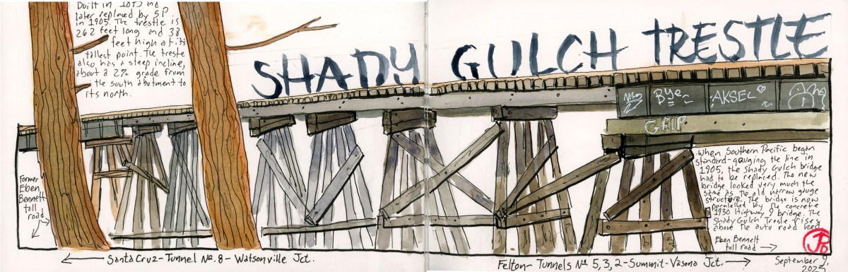
Just up the creek from my cabin is one of the remaining wooden trestles on the former South Pacific Coast Railroad (in 1887 the railroad became Southern Pacific). This is the Shady Gulch Trestle.
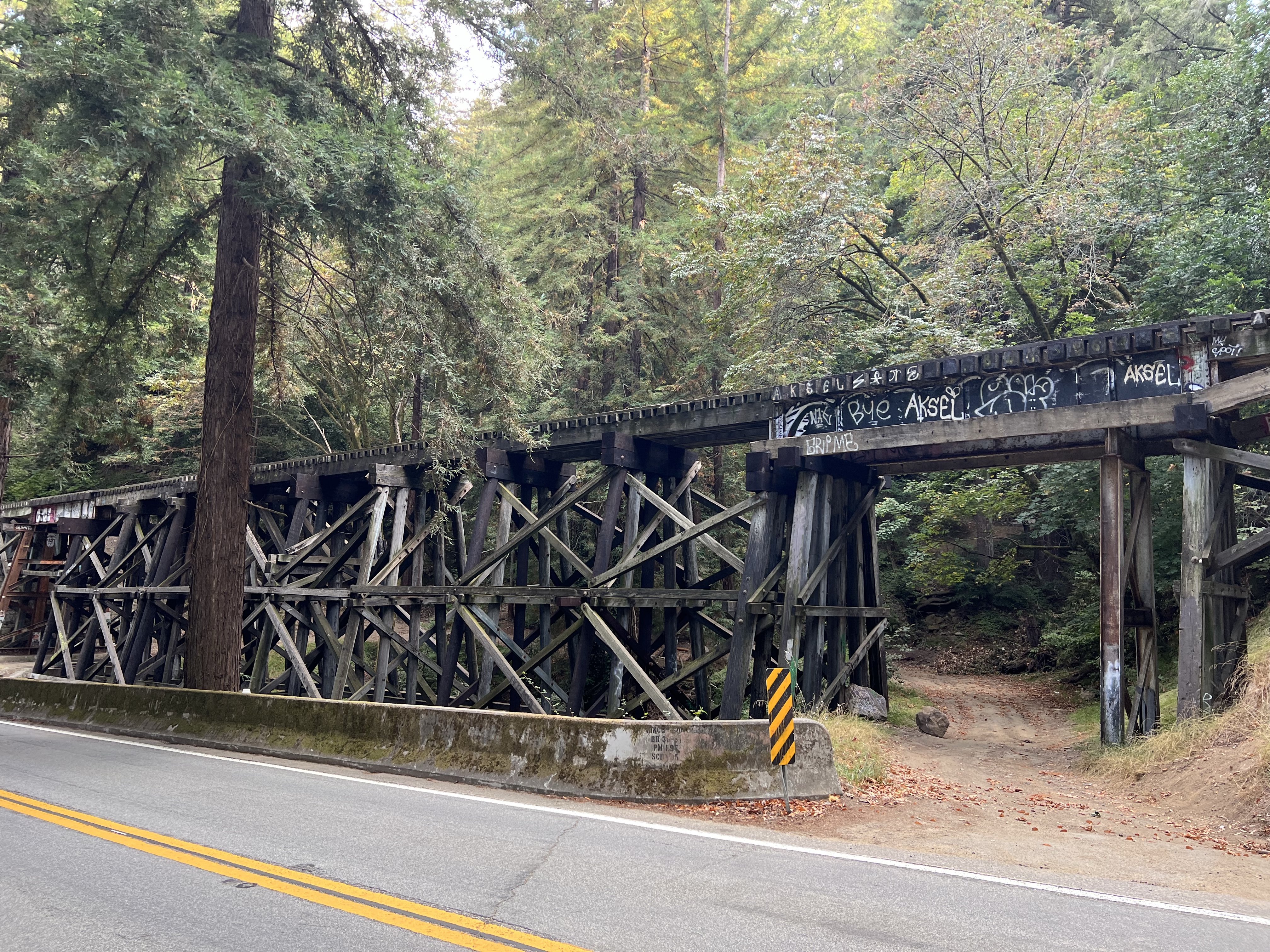
Not only does this trestle still exist but is still used for rail service on the Big Trees and Pacific Railway.
Shady Gulch Trestle with the Highway 9 concrete bridge (1930) in the foreground. The dirt road to the right is the former Eben Bennett toll road. The concrete highway bridge replaced the toll road.
The original trestle was built in 1875 to span Shady Gulch. At the time, the line was built for the narrow gauge South Pacific Coast Railroad. When Southern Pacific acquired the line they rebuilt the trestle in 1905 to accommodate standard gauge.
The trestle of today very much looks like the original narrow gauge trestle of the late 19th century, sans graffiti of course.
The afternoon Felton-bound Big Trees and Pacific crossing the Shady Gulch Trestle. This tourist train tends to stop traffic on Highway 9.
My father spend his childhood summers in the cabin in the 1930, 40s, and 50s. He would tell me of the time a freight would be climbing the grade on the trestle on their way to Felton on a foggy summer’s morning. The wet track would cause the locomotive’s driving wheels to slip. And after many slips and the hyperbolic “chuff-chuff-chuff” of the stream exhaust, the train would back down the grade, sanding the track as they reversed. The freight would make another attempt, this time slowly with the sanded rails helping the drivers grip the steel. And off they went to Felton.
There is a single one car pull off on the north side of the highway bridge. I made three attempts to sketch the trestle but was foiled by a camper van that was camped out in the spot.
Was this guy going to spend the night here? On my third attempt of the day, in late afternoon, the van was finally gone and I was able to park, set up my sketching chair, and start my sketch of the trestle.
I timed my sketching time with the Felton bound afternoon Big Trees and Pacific train.
One of the more interesting tunnels on the South Pacific Coast Railroad is Tunnel No. 5 in Zayante.
This is one only two tunnels on the former South Pacific Coast line that is still in use, although not by a railroad.
As the railroad climbed its way up Zayante Creek it came to a granite outcrop that the builders could not go around or over so they had to tunnel through it.
Granite is stable and solid and because of that they did not have to add any interior wooden supports. When completed Tunnel No. 5, at 250 feet, was the second shortest on the line.
The tunnel was active until the Southern Pacific’s abandonment in November of 1940.
The tunnel began it’s current use in 1952 when the Western States Atomic Vault Company bought the tunnel, sealed both ends and used Tunnel No. 5 as a fire-flood-nuclear-proof storage silo, housing records (mainly microfilm and microfiche) for many companies including Disney. The silo officially opened on May 2, 1954.
The eastern portal was made the entrance to the facility and a guard shack was built (featured sketch) where a guard was stationed 24/7. We did not see any signs of a guard so we could not ask for a tour. (The facility is currently owned by Iron Mountain).
In times past, the company would allow tours inside the facility and one visitor deemed it the “most interesting dull place in the world”.
One can only guess the nearly 70 year old “secret” files that now reside in the former railroad tunnel known as Tunnel No. 5.
Peeping through the fencing toward the eastern portal of Tunnel No. 5. One of the two windowed buildings appears to be the guard shack. The parking lot now looks like an odd junk sale with junk that no one wants to buy!The former rail bed (sans rails) looking towards Eccles and Felton and Santa Cruz.
On a historic rail sketching adventure, Grasshopper and I headed up into the Santa Cruz Mountains to sketch a portal of one of the longest rail tunnels on the former South Pacific Coast Railroad (later Southern Pacific) route.
This 28 mile route started at Vasona Junction in Los Gatos and climbed over the Santa Cruz Mountains to the beach town of Santa Cruz.
Part of this route still exists as the Big Trees and Pacific Railroad which operates a tourist train from Felton to the Santa Cruz Beach Boardwalk.
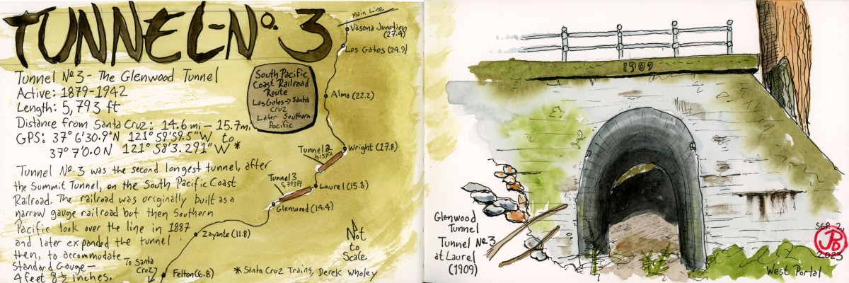
The tunnel we were looking for is the Glenwood Tunnel, also known as Tunnel No. 3. This 5,793 foot tunnel was active from 1879 to 1942. The original tunnel was built for narrow gauge but when Southern Pacific took over the line in 1887, they later converted the line to standard gauge (4 ft 8.5 in).
When the South Pacific Coast Railroad was first planned, then had to figure out how to get the road bed into the San Lorenzo Valley. To do this they had to built two one-mile long tunnels: Tunnel No. 2 (Summit Tunnel) and Tunnel No. 3 (Glenwood Tunnel).
From northbound Highway 17, we took the Laurel exit heading towards the former township of Laurel. We passed a few mountain homes and two bikers laboring up the hill as we headed down towards the former rail-bed.
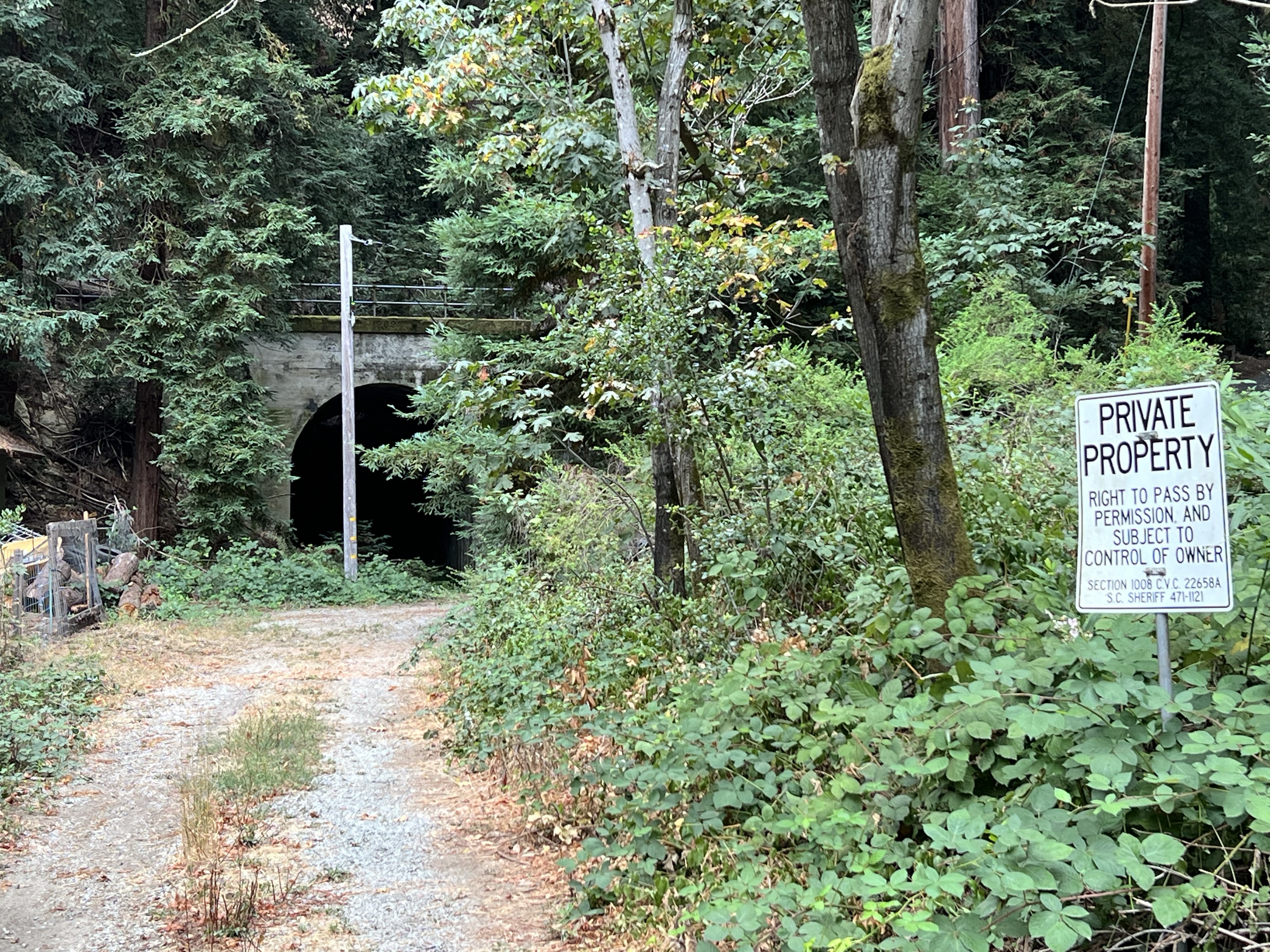
We parked and headed out to a get a better look. The west portal of the Glenwood Tunnel was visible, but parts were obscured by trees and a power pole. The “private property” sign kept us at bay. Was this the best view we would get?
The not-so-great view.
I climbed up a side road, probably also private property, that parallels the rail bed, to get a better sketching vantage point. Even here, the portal was obscured by redwoods but I started a sketch anyway (which, like Tunnel No. 3, I abandoned).
Not being satisfied with the sketch I returned to where Grasshopper was sketching. His only company was a barking dog on the other side of a fence. There was a house just to our left.
A man peeked over the fence with his cup of coffee and said, “You can walk up to the tunnel if you want.”
This was the owner of the house (let’s call him “Bill”) and we had a nice conversation with him about living in the redwoods, winter storms, history, his spring-fed water system, and trains and tunnels.
We thanked Bill and walked around the chain that crossed the rail bed and headed towards the western portal of the Glenwood Tunnel. Now this was the way to sketch the tunnel (featured sketch).
Grasshopper sketching the western portal of Tunnel No. 3. Bill’s spring-fed water system can be seen on the right.Corvidsketcher in the western portal of Tunnel No. 3.
We walked into the 1909 concrete portal. The tunnel ended in about 50 feet.
In 1940, winter storms and landslides closed portions of the route permanently. Southern Pacific made the decision to abandon the line. The major tunnels were dynamited at both ends, closing the tunnels for good. The concrete portals are all that still remain.
Now that we firmly had tunnel fever, we had to find the other side of the tunnel, the eastern portal.
Tunnel No. 3 now passes under Highway 17 so you have to cross over the highway to find the other end.
The eastern portal of the Glenwood Tunnel at Glenwood Drive.
The eastern portal of the Glenwood Tunnel is much harder to get to than the western portal. To get a comparable view you would have to scrabble down a steep hillside or trespass through a stable to reach the rail bed which now seems to be a creek bed.
So we had to make due and sketch the portal from the side of Glenwood Drive, which the concrete portal now supports.
The big house, the bucket, the calaboose, the cooler, the gray bar hotel, the hoosegow, the joint, the jug, the pen, the pokey, the slammer, and stoney lonesome.
These are all slang for jail.
On my way down the coast, I did a Friday afterwork jail sketch in the town of Half Moon Bay.
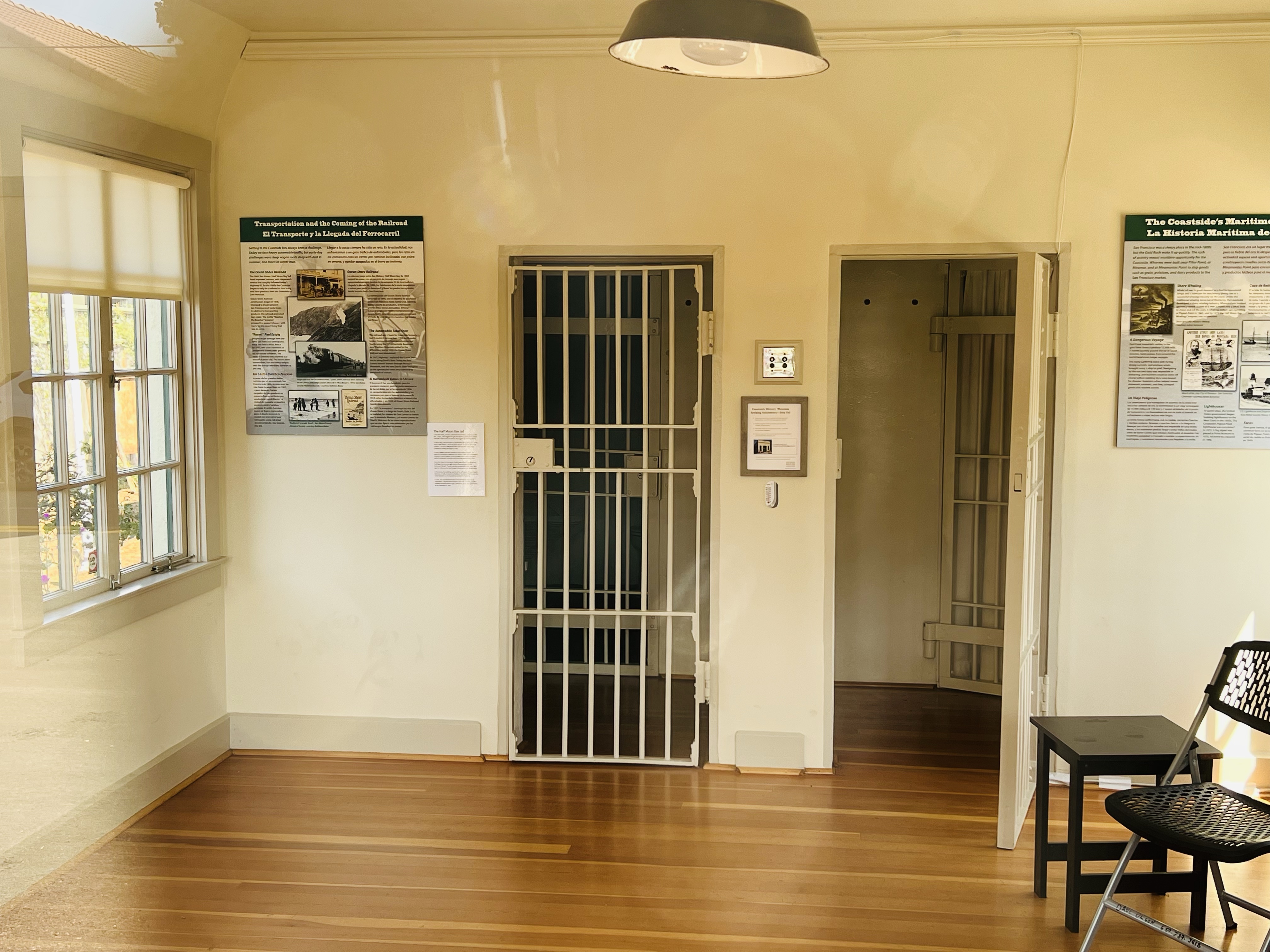
On a side street that parallels Main is a small building that sits alone. In case anyone wondered what this building was, it reads “JAIL BUILT-1909” in big black letters across the top. (The jail was actually built in 1919.)
This was Half Moon Bay’s small two-cell jail. This isn’t, even with the wildest imagination, the Big House.
The jail is built of reinforced concrete on a concrete foundation, built to keep people in. Not like it’s formerly interned were serious criminals. The cost of the jail was $3,000.
The Half Moon Bay Jail reopened in 2018 as a historical museum. The two cells and constable’s office.
The jail held prisoners until they could be transferred to the county jail in Redwood City. Locals also spent the night here having had too much fun in Half Moon Bay’s saloons.
The jail was used as a jail and sheriff’s office until 1967 where it was little used until it was reopened as a historical museum in 2018. It is the oldest public building in Half Moon Bay.
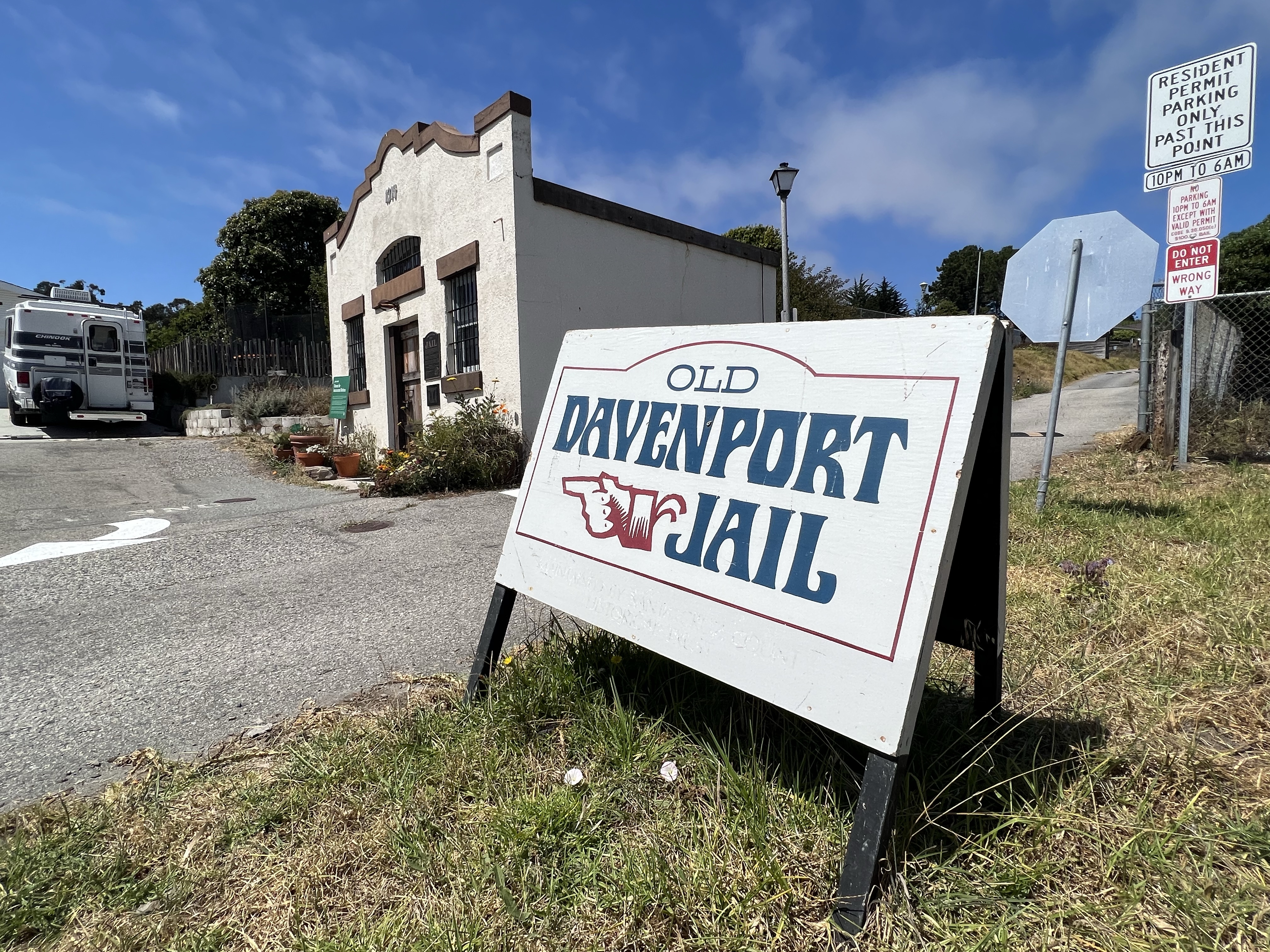
I then headed 45 minutes south on Highway One to the small town of Davenport to sketch their small jail.
This two-cell jail was built in 1914 of Santa Cruz Portland Cement, made at the Davenport Cement Plant. This small jail was built to last and looks solid for a building that is over 100 years old.
The jail housed two horse thieves from San Mateo and like Half Moon Bay, locals that had imbibed a bit too much in Davenports’s saloon.
In 1936, when the new jail on Front Street in Santa Cruz was built, the Davenport clink became redundant.
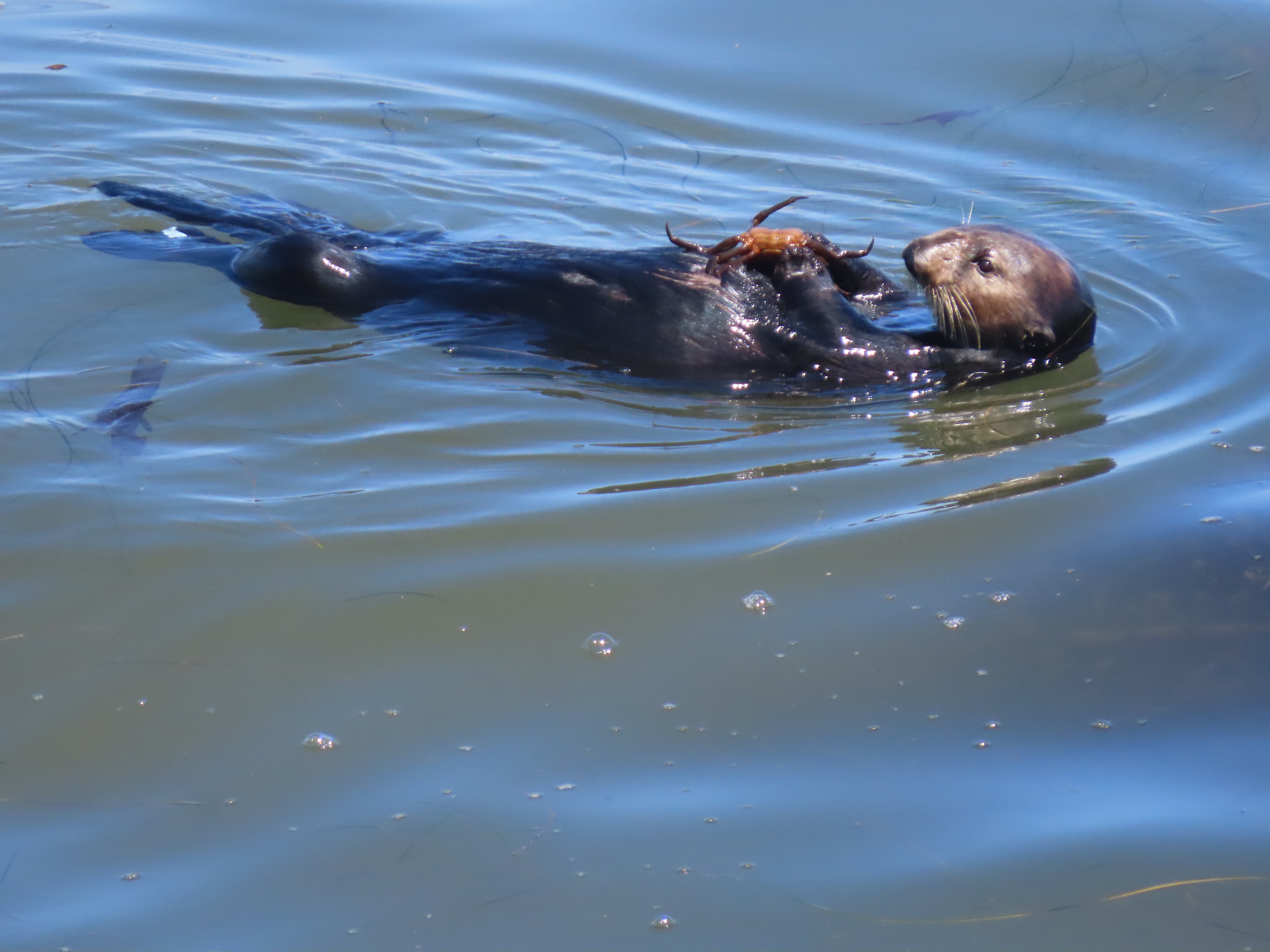
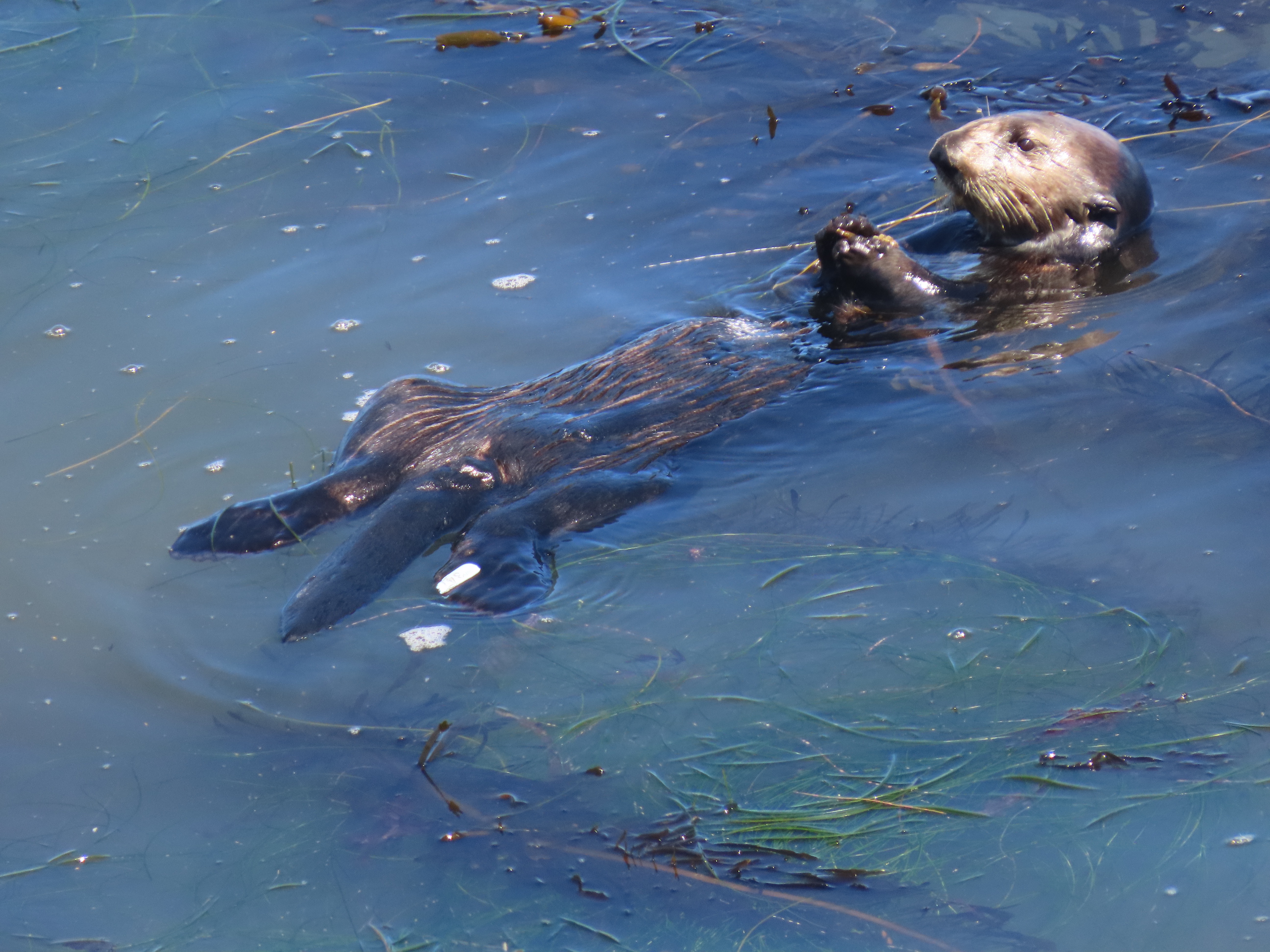
It is nice to see sea otters along the Santa Cruz coast. Laying on their backs, bashing a mollusk to death or eating a crab, recently caught, and still alive, one foot at a time, or rolling in the kelp, belly full, and settling in for a nap.
Fresh caught crab is on the menu off of West Cliff Drive.
This marine mammal was hunted to near extinction because of their pelts. Now they are protected and have prospered on the California coast.
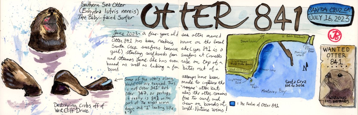
A five year old female, branded a “terrorist” by some in the media, has grabbed the world’s attention.
This is Otter 841.
Otter 841 was born in captivity and then released to the wild. Her mother, Otter 723 was taken out of the wild because she was habituated to people and was approaching kayakers begging for food. It was apparent that Otter 723 was being fed by humans.
While in captivity they realized that Otter 723 was pregnant and she soon gave birth to our troublemaker Otter 841.
841 was released to Monterey Bay where for four years she swam under the radar.
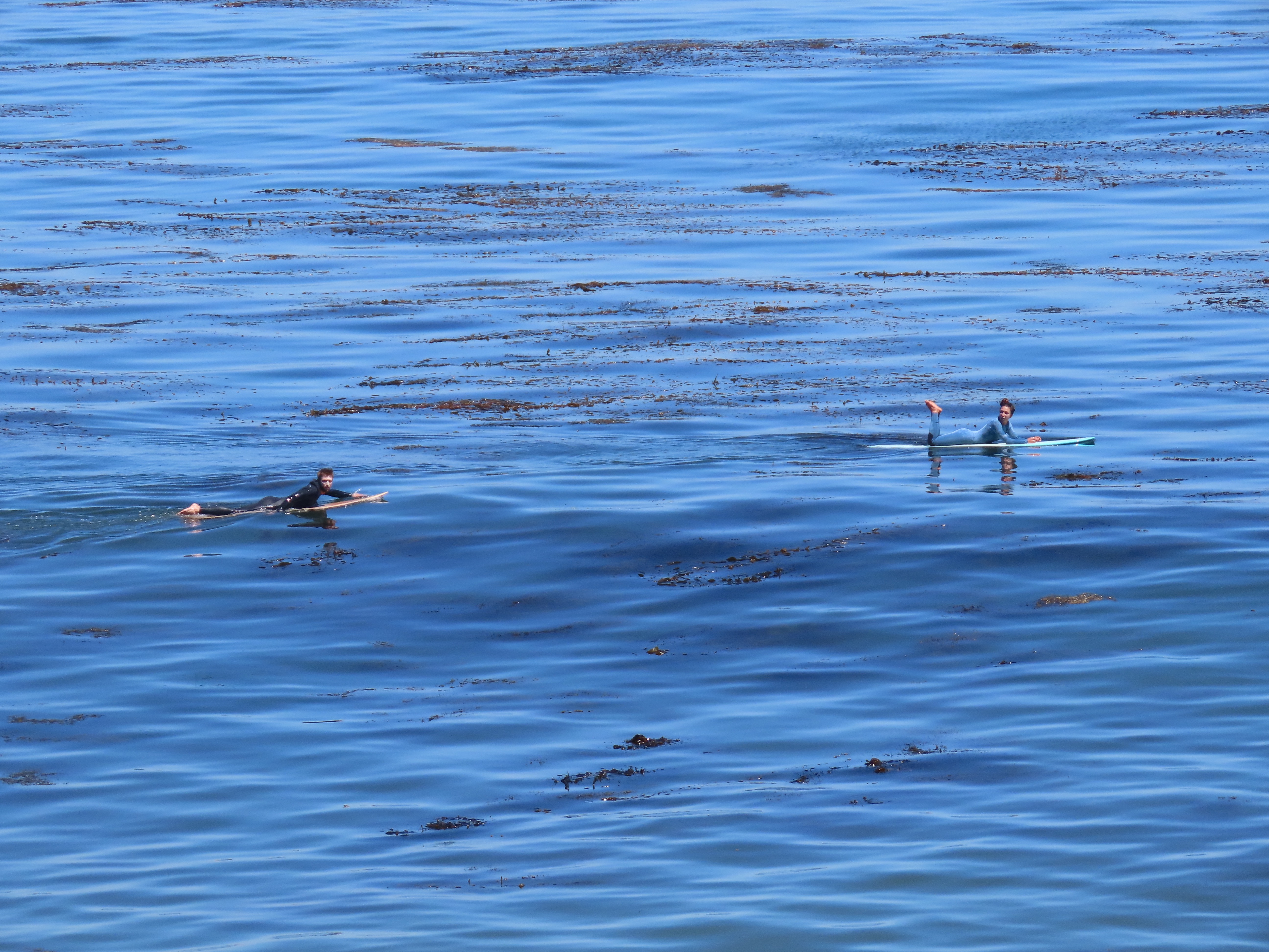
Starting in June of 2023, 841 has become a surfboard pirate. The otter has been observed and photographed jumping up onto surfboards, dislodging it’s surprised rider, in the popular surf spots of Steamers Lane and Cowells. On one occasion, 841 took some bites out of a surfboard.
Is this Otter 841? On the otter’s left flipper is a light blue tag with a three digit identification number. Surf at your own risk! Surfers keeping an eye on the infamous otter.
The powers that be decided that 841 should no longer be in the wild and attempts were made to capture 841 employing the cunning use of a surfboard. They tried and tried again but they could not capture the piratical otter.
And as of publishing, Otter 841 still swims free off the coast in Santa Cruz.
Don’t mess with nature because nature usually wins.
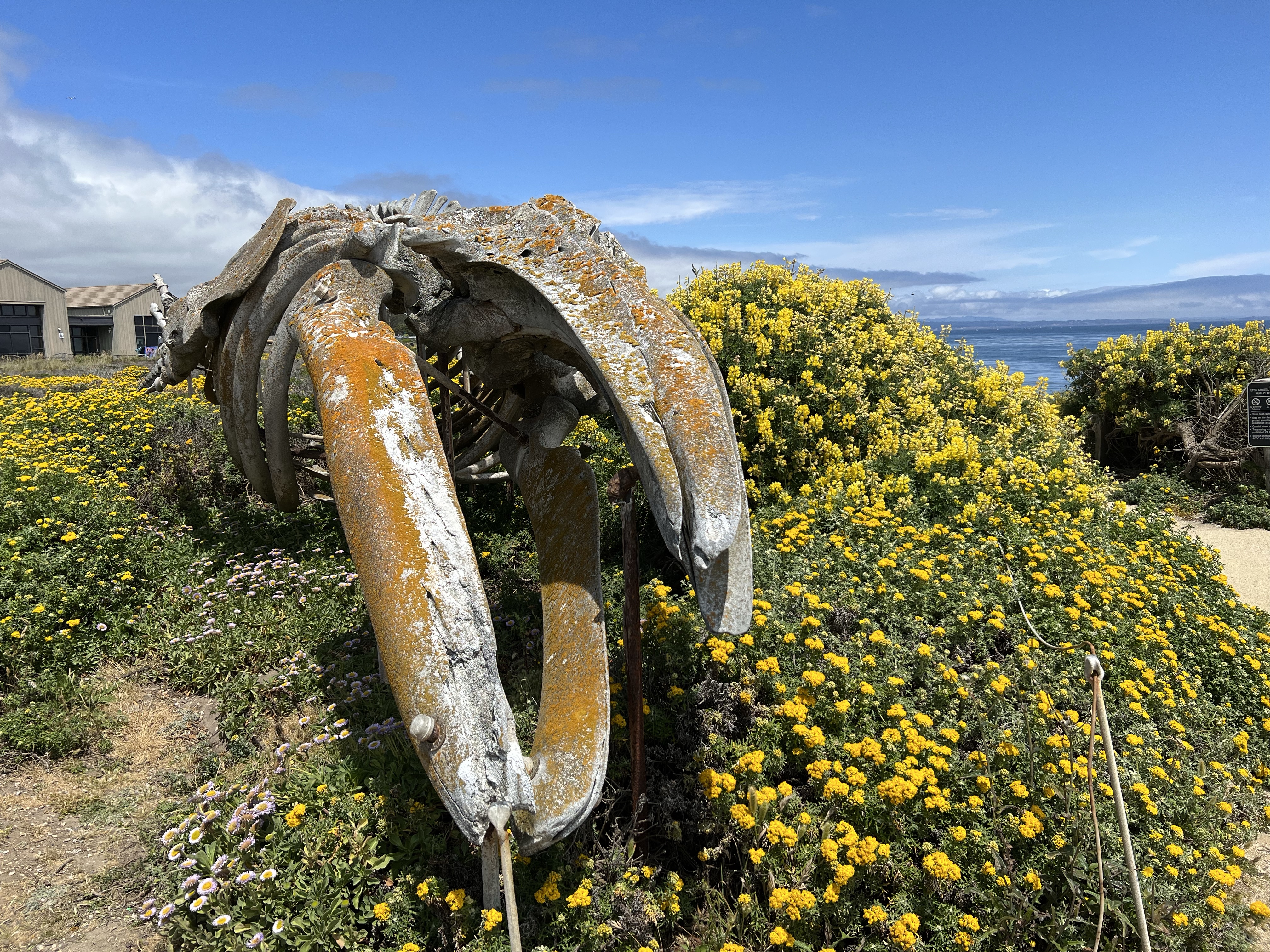
One joy of sketching is to return to a previous subject but sketch it from a different perspective. Such is the case with the whales of Long Marine Lab in Santa Cruz. (Former cetaceans, that is.)
Long Marine Lab is part of the University of California at Santa Cruz (UCSC) and is a research and educational facility for marine biology. The campus also features a small aquarium (the Seymour Marine Discovery Center) that is open to the public. The biggest draw for me is the biggest creature that ever lived on Planet Earth: the blue whale. The Discovery Center has an incredible blue whale skeleton on display flanking one side of the museum.
I had sketched the massive blue whale skeleton and the smaller gray whale skeleton before but I wanted to sketched them in a different way. For the blue, I stood directly in front and sketched it head on, as if the largest creature on Planet Earth was swimming towards me.
I have been lucky enough to see blue whales in the wild from pelagic boating trips. Most of these trips have been in Monterey Bay. I remember the first time I saw this massive cetacean on a trip out of Monterey Harbor with my father in the late 1980s. My high school biology teacher at the the time didn’t believe blue whales could be seen in Monterey Bay, until I showed him the photos.
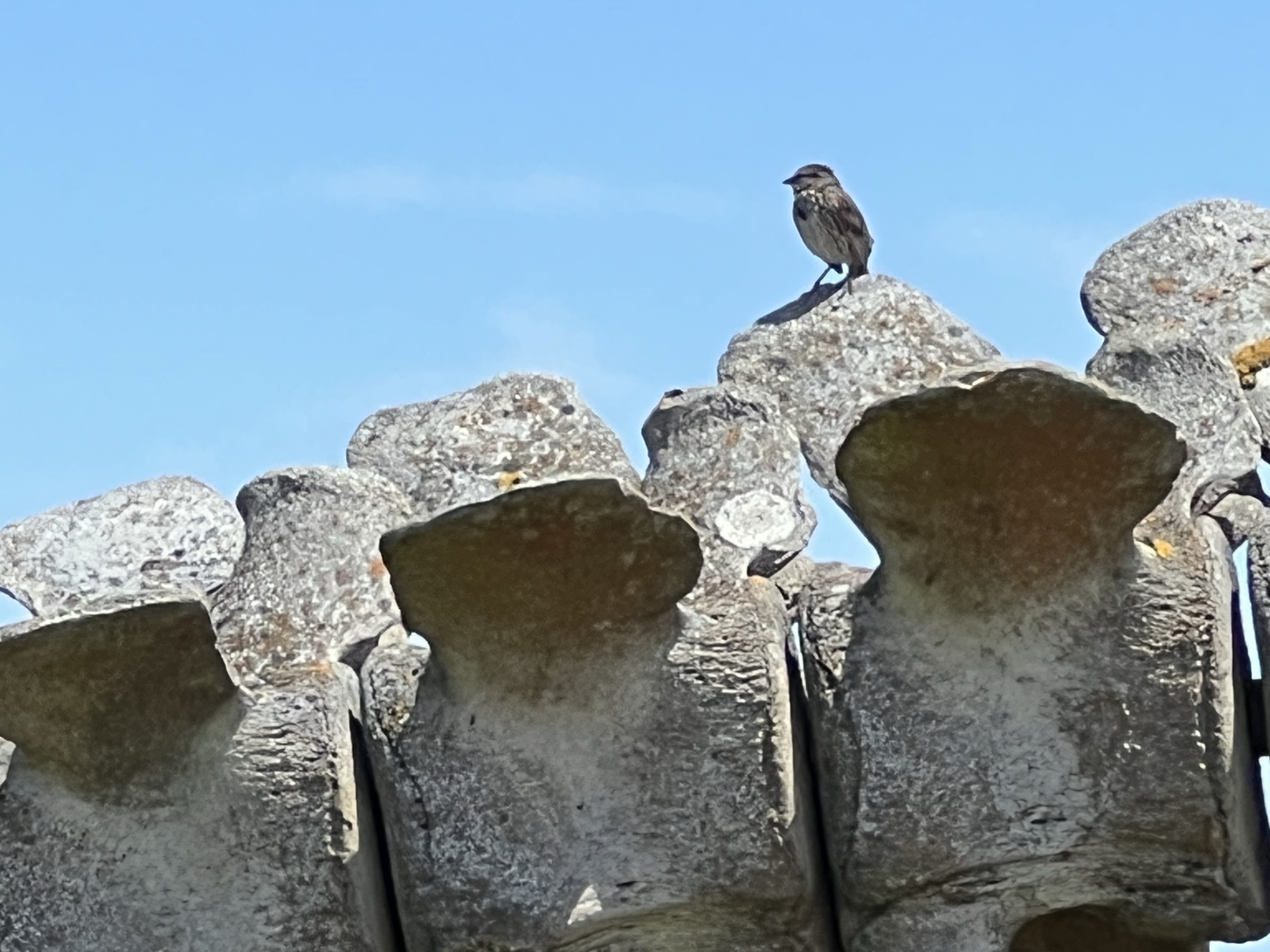
Song sparrow using the vertebrae of the gray whale for a singing perch. Gray whale skeleton with the Seymour Marine Discovery Center on the left and Big Blue on the right.
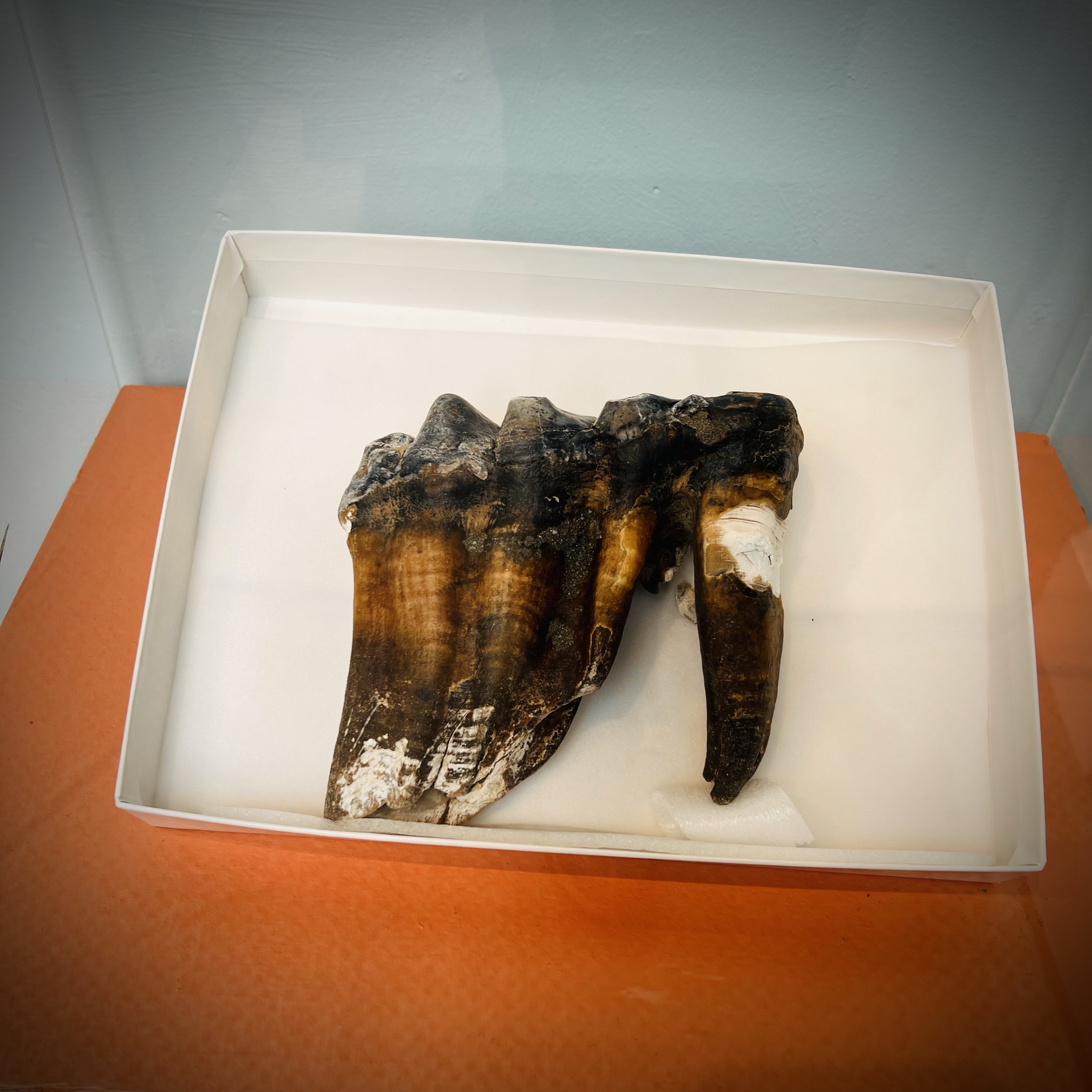
In late May, something interesting washed up on Rio Del Mar Beach in Aptos on the shore of Monterey Bay. It was not your standard bit of driftwood, a dead marine mammal, or a piece of flotsam from Japan.
In fact the jogger who found it did not know what she found, so she took a picture of it and did what most of us seem to do nowadays: she posted the picture on social media. Someone who did know what it was saw the post and that person was Wayne Thompson, the Paleontology Advisor for the Santa Cruz Museum of Natural History. He identified the object as a tooth from an extinct mastodon!
When they returned to the beach the tooth was gone. So a search was begun to find where the molar tooth has gone through national and even international media. The efforts soon turned up the tooth. A local man saw the tooth on the beach and took it home. He saw that this was being sought after and he called the Santa Cruz Museum of Natural History.
The tooth was put on display at the museum for three days on the first weekend in June. And that is where I saw the tooth and sketched it.
The recently found mastodon molar in a box, on display for three days at the Santa Cruz Museum of Natural History. I sketched it on the second day.
When I first stepped into the museum, it was much busier than usual. In front of the mastodon display stood the man himself, Wayne Thompson, being interviewed by a local news station. He told the reporter that the tooth was probably washed down Aptos Creek during the record rains of 2023 and then washed up onto the beach. This was a big story. I was told that NPR would be visiting the museum on Monday.
Mastodons are related to the wooly mammoth and the modern elephant. The Pacific mastodon (Mammut pacificus) once roamed the land that became California between five million to 10,000 years ago. So the tooth was an incredible and rare find. In fact the name mastodon comes from ancient Greek meaning “breast tooth”, referring to the nipple-like appearance on the crown of the molars.
Mastodons disappeared from North and Central America about 10,500 years ago. It believed that the mastodon was driven to extinction by early human hunters.
The 2022-2023 atmospheric rivers (nine in total) dumped rain, strong wind, and storm surges on Santa Cruz County causing an estimated $100 million worth of damage.
In a 22 day period, the storm dumped 35.38 inches on the town of Boulder Creek in the Santa Cruz Mountains, 39.55 inches on Santa Cruz (a record amount) and left 15 feet of snow over Donner Summit. The storm systems dumped an estimated 32 trillion gallons of water on California and the storm left 20 people dead, including the man killed by a falling cypress in Lighthouse Field in Santa Cruz.
On Thursday January 19, the county got a very rare visit by a sitting president. The last president to visit the area was Theodore Roosevelt in May of 1903. There has to be some serious damage in order for the president to hop on Airforce One and fly cross the nation to the Monterey Bay Area.
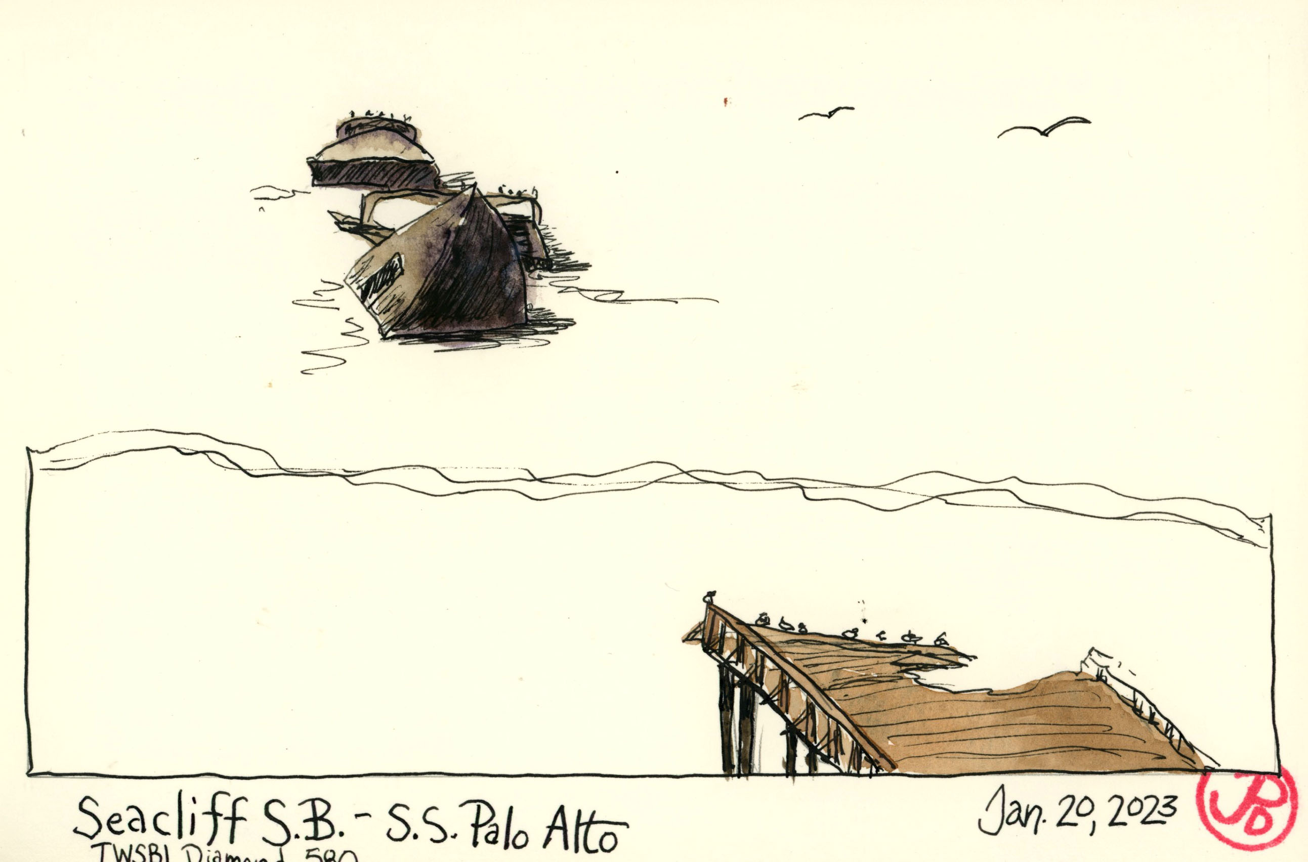
President Biden visited the damaged Capitola Wharf and then headed to Aptos to view damage at Seacliff State Beach, home to the “Concrete Ship” the S. S. Palo Alto.
The Capitola Wharf was damaged by storm surge on Thursday January 5, taking out a 40 foot section of the 855 foot historic wharf, which was built in 1857. I intended to visit and sketch the wharf.
I weaved my way through residential streets of Capitola heading toward Capitol Village and the damaged pier. I found free parking on Prospect Ave (miraculously find!) and headed east toward Cliff Drive. The berm shrouded the beginning section of the wharf and as I walked east, the true damage appeared and it was shocking to see, even though I had seen photos and videos of the damage during news coverage.
Where’s the wharf?
Today was a beautiful winter day: clear skies, light wind, and temps flirting with the low 60s. I tried to image what the scene before me looked like 15 days ago. I tried to image the intense wind and rain and the 30 foot waves that engulfed the wharf, eventually taking large pieces of the wharf away and depositing them inside sea-fronted business. It was hard to image this on such a beautiful day.
I found a bench and opened up my Stillman & Birn Delta panoramic sketchbook and used my telephoto sketcher’s eye to zoom in on the damaged section on the wharf.
Using my sketcher telephoto view.
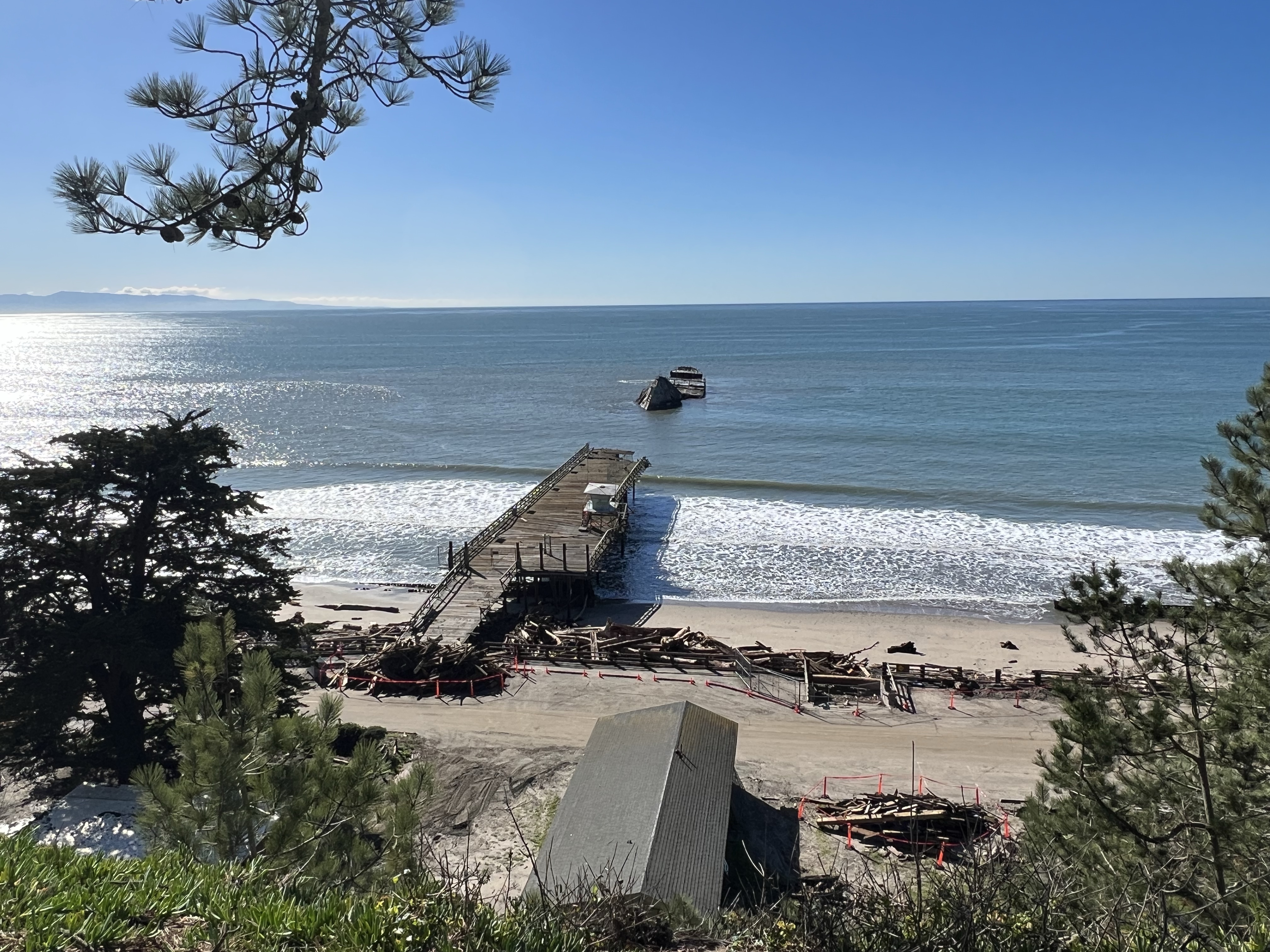
I then headed south on Highway One for a short drive to Seacliff State Beach in Aptos. It was here that the president viewed another damaged wharf and then gave a press conference about the damage he viewed and federal emergency funding.
From the upper parking lot I looked out to the segmented and ruins of the “Concrete Ship”, the S. S. Palo Alto. The ship had been torn into three pieces by a series of storms in the past but now it looked like the ship was further off shore than normal. This was really an optical illusion because the wharf that reached the ship’s stern was all but destroyed in the recent storms, leaving the Palo Alto looking like a rusting isolated island chain crowned in cormorants, gulls, and pelicans.
I sketched the ship with my new TWSBI Diamond 580 fountain pen. I had sketched this ship before in it’s various stages of decompose. I remember a time when I was a child when you could actually walk out on the pier and to the ship. Those days are long gone.
The destroyed wharf, the Palo Alto (in three parts), and the line of debris on Seacliff State Beach.
The Palo Alto was built at the end of World War I and launched in May of 1919. She was designed to be a tanker but was finished too late as the war ended. She was mothballed in Oakland and then purchased by the Seacliff Amusement Company in 1929. The pier was built in 1930 and the ship was used as an “amusement” ship with a swimming pool, a dance floor, and a cafe.
The company soon went bankrupt and the ship was sold to the state and it was then used as a fishing pier. Around this time the ship cracked in the middle during a winter storm. A February storm in 2016 pushed the ship on it’s starboard side and the ship is now in three or more pieces.
An Aptos mural by Ann Thiermann of the S. S. Palo Alto in better days. That man shouldn’t be feeding that pup ice cream!
It’s always nice to the start the new year of with a life bird. So much better if the bird is a mega rarity!
This was the Eurasian chat the red-flanked bluetail (Tarsiger cyanurus).
The bird was the sixth California record and only the second chasible bird (that is if you have an ocean going vessel), the other four records are from the Farallon Islands. It was found on December 28, 2022 in a park near the Santa Cruz Lighthouse on West Cliff Drive.
I had planned to head down on New Year’s Day to Lighthouse Field State Beach in Santa Cruz with Grasshopper but on December 31, after record heavy rains, a large cypress tree at the park fell and killed a 72 year old man. The park was closed for safety concerns.
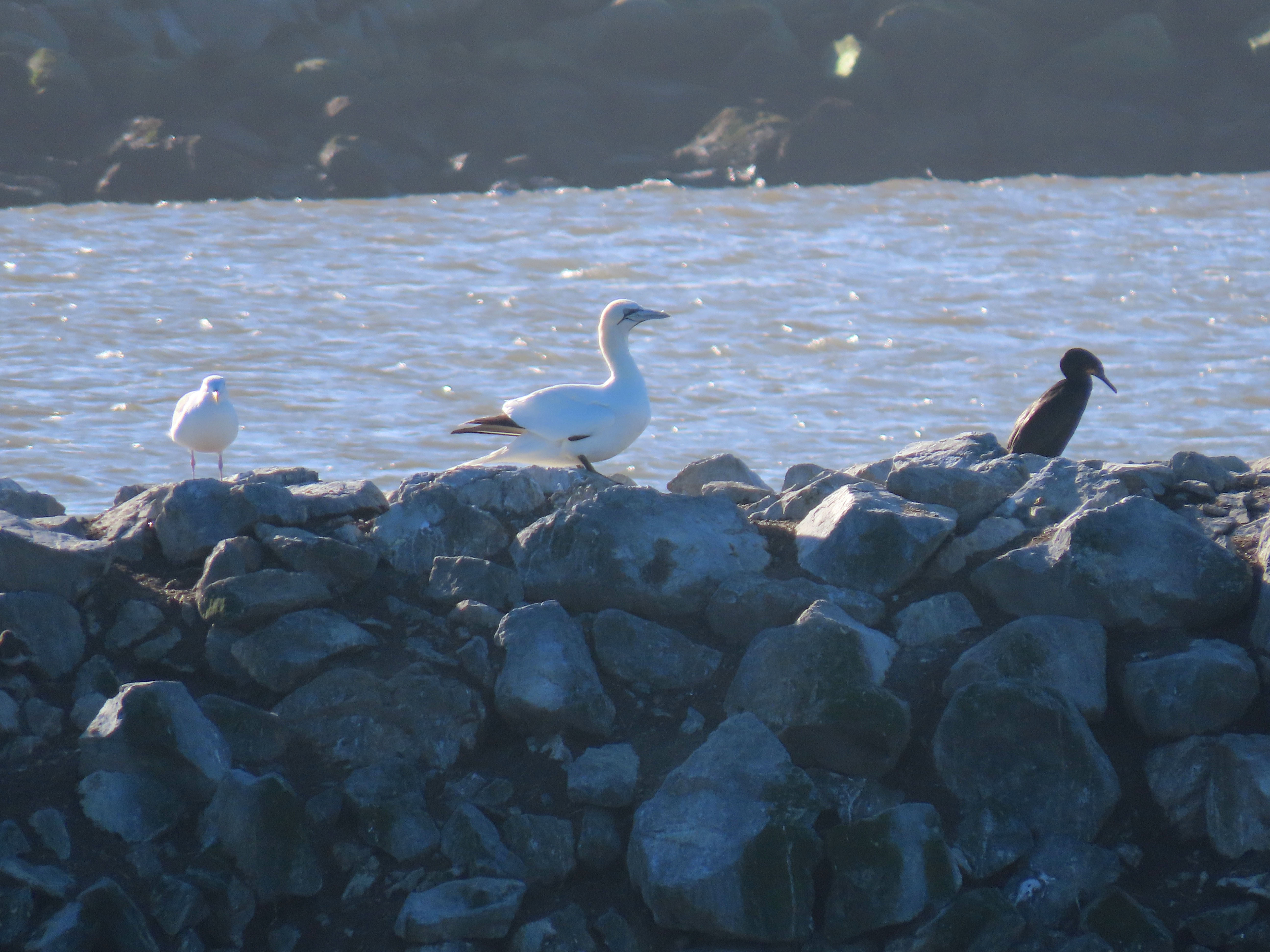
So our Plan B was to bird the San Mateo County coast and have a go at the continuing northern gannet at Pillar Point Harbor.
Highway 92 was closed because of the intense rainfall so it was Highway One down the line to Pillar Point.
We checked the breakwater for a large white bird. No gannet. Heading south, the beaches seemed devoid of gulls. The historic rains had washed away large parts of the beaches, the creeks were flowing at a high capacity turning near shore waters a muddy brown. Not a great day for birding, well not yet anyway.
We reached as far south as Pescadero State Beach, looked out at few roosting gulls (it was still too early for kittiwakes) and returned north to try again for the consolation gannet
Johnson Pier was now crowed with people buying fresh crab and cod from fishing boats in the harbor. We weaved our way out to the end of the pier to look for an out-of-place big white seabird. Grasshopper spotted the gannet, named “Morris” by locals, immediately. The gannet, the only one on the west coast, was preening and the local gulls and cormorants were giving Morris a wide berth.
The much larger northern gannet sticks out like a sore thumb.
After getting good looks and a few photos, we saw a report that the bluetail had been seen and heard earlier in the morning. So some birders where getting access to the park. After a quick ponder we knew what we had to do: head south and retrace our journey and not stop until we where parked next to Lighthouse Field State Beach.
About an hour later, we parked on a side street, geared up, and entered the park. Still unsure of the location, we knew we had to find the semicircle of birders, intently gazing into the bramble. We began to head east on the trail, dodging puddles that were not far from being ponds, when we spotted the large cypress tree that had fallen across the path in front of us.
The cypress was over 100 feet tall, the papers put the tree at 120 feet, and just beyond the tree and to the left we saw a some birders looking off to the left. The only way to get over the tree was to climb over. Other had already trampled down a path through branches that were now facing upward. Once we got to the location of the bluetail, there were already about 35 to 40 birders in attendance, with more arriving as we searched.
This bird was going to be tough because it was sulky and shy, so patience and perseverance would be needed. Good thing I’m an elementary school teacher!
The bird was being seen among the grasses and branches and the bluetail was moving quickly, not pausing for long. I saw movement a few times which I thought was the bluetail but I wanted better diagnostic looks before I added the bluetail to my list. After about 30 minutes, I finally got a good look at the tail of the bluetail, which was blue and I noted how the bird frequently jerked it’s tail downward like a flycatcher. World life bird number 1,707!
Once I got my views, I stepped aside to let others from the back start their search. I started my anchor sketch of the downed cypress tree and reflected on the tragedy of a man’s death, while not far away, birders chortled in ecstasy.
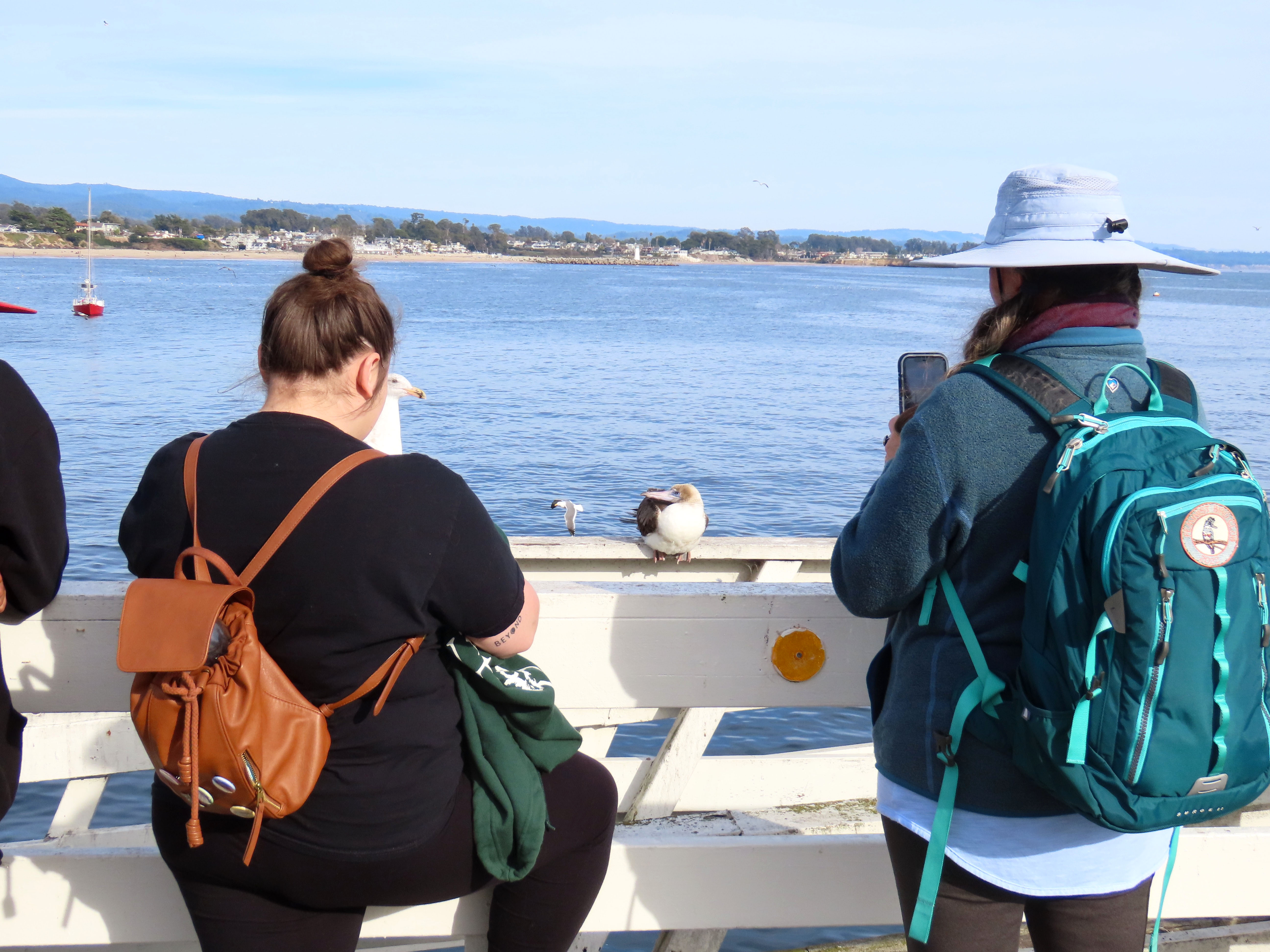
The first red-footed booby (Sula sula) I had ever seen in Santa Cruz County was perched on the pier out to the Concrete Ship at Seacliff Beach. But the booby that has recently been hanging around Santa Cruz Wharf was a much more incredible and close bird.
The booby was first seen towards the end of the wharf on November 3. At the time, local birders assumed the booby was sick because it appeared very lethargic and allowed a very close approach from viewers, including some selfies seeking tourists. A local birder had to put up yellow caution tape to keep the booby admirers at bay.
The red-footed booby is a bird of the tropics and not the foggy coast of Northern California. The common name comes from the Spanish “bobo”, meaning buffoon. This refers to the ease in catching the bird and it’s awkward gait on land. Many of these seabirds experience “island syndrome” and because of their isolation from humans, they show little to no fear of them. (Think of the now extinct dodo). This tropical visitor showed no fear to the humans walking up to it when even a gull would fly away.
On Friday afternoon, I drove out to the end of the wharf. The booby had been reported across from the Dolphin Restaurant, which is one of the last eating establishments at the end of the wharf.
I parked across the street from Stagnaros and looked up and 20 feet away was the red-footed booby perched on the wharf railing! There was also a small audience taking pictures of the wayward rarity.
The red-booby with a few of it’s admirers. They are about six feet away from the booby.
I got out of my car and snapped a few photos and then I took out my sketchbook to get a sketch in. It was easy to sketch the booby because the bird was about six feet away and seemed completely unfazed by the birder paparazzi.
The red-footed booby of Santa Cruz.
It was great to observe the booby up close with the naked eye. It was a little challenging to sketch as it was in constant motion, preening or tucking it bill into it’s feathers for a quick nap or keeping a western gull at bay.
Sula sula and a western gull.
From my observations, the booby was well and thriving. It had been seen fishing with gulls, cormorants, and pelicans in the bay so I assume it was finding plenty of fish. It landed on the wharf rail to preen and rest.
Let’s hope the world’s smallest booby stays with us throughout the winter!
A quick field sketch of the wayward booby. I used my Lamy Safari for this sketch and because the black ink was not waterproof, it bleed into the paint. For the featured sketch, I replaced the ink with Noodlers Black ink which is very waterproof.