Image

KPIG, 107 “oink” 5 FM

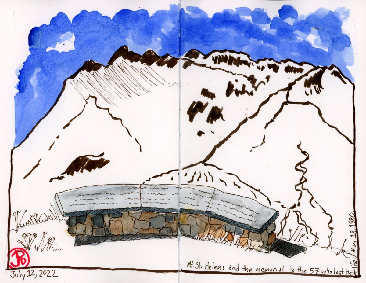
It’s a bit like the man behind the curtain in the Wizard of Oz. The music and voices comes through the car radio, but where does it really come from?

In my mind’s eye I envisioned a tall building with radio towers crowning the roof and an expansive studio on the top floor where a large staff puts together playlists and commercials while the DJ speak to their devoted listeners, taking requests and forecasting the weather and traffic patterns.

While I’m down in Santa Cruz, my radio is often tuned to 107.5, which is the frequency of the legendary radio station, KPIG. KPIG plays Americana (and other worldly music) music: rock, folk, blues, bluegrass, western swing, country, reggae, and everything in between.

The radio station identifies it’s location as Freedom, California but in reality the station is based in an unassuming building in Watsonville, across Main Street from Ramsey Park. Freedom does have a much nicer ring than Watsonville!

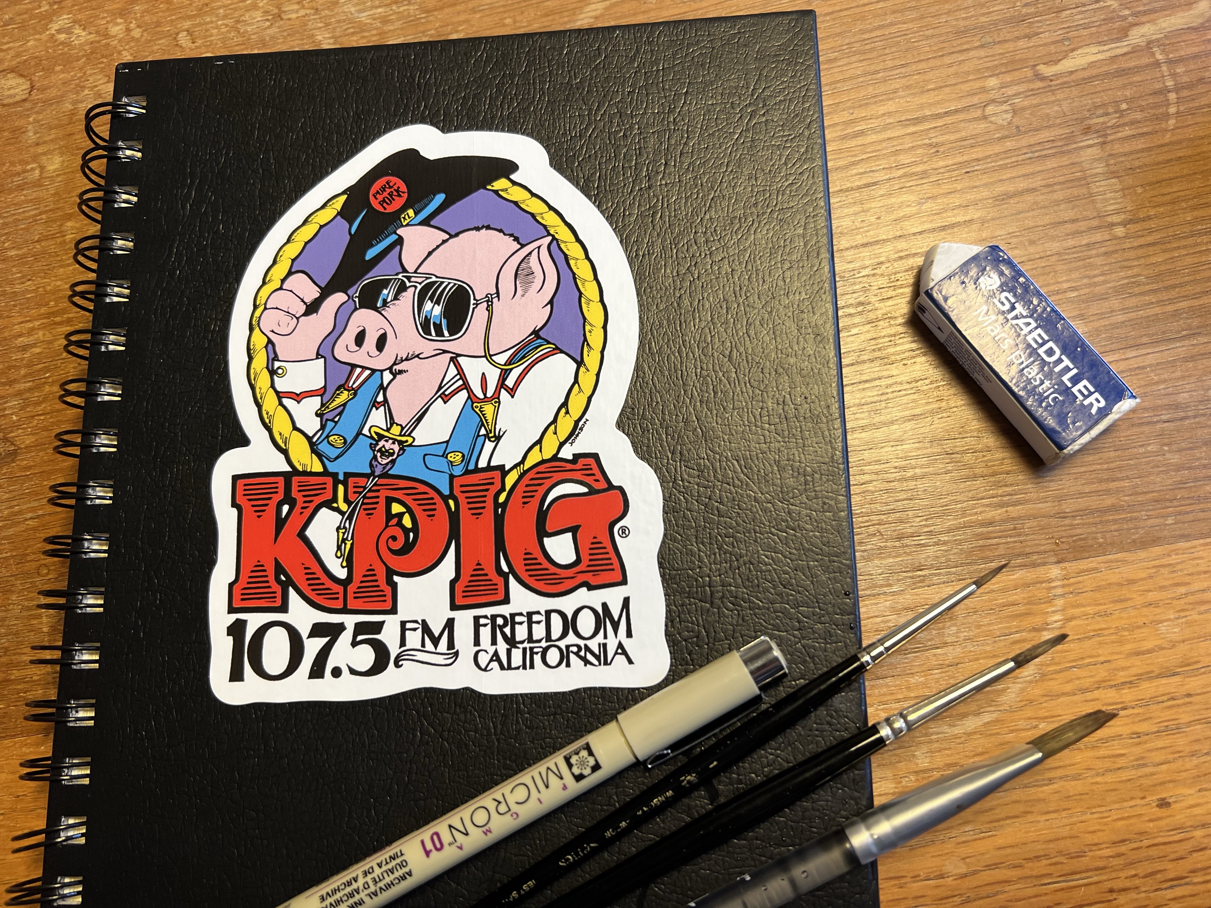
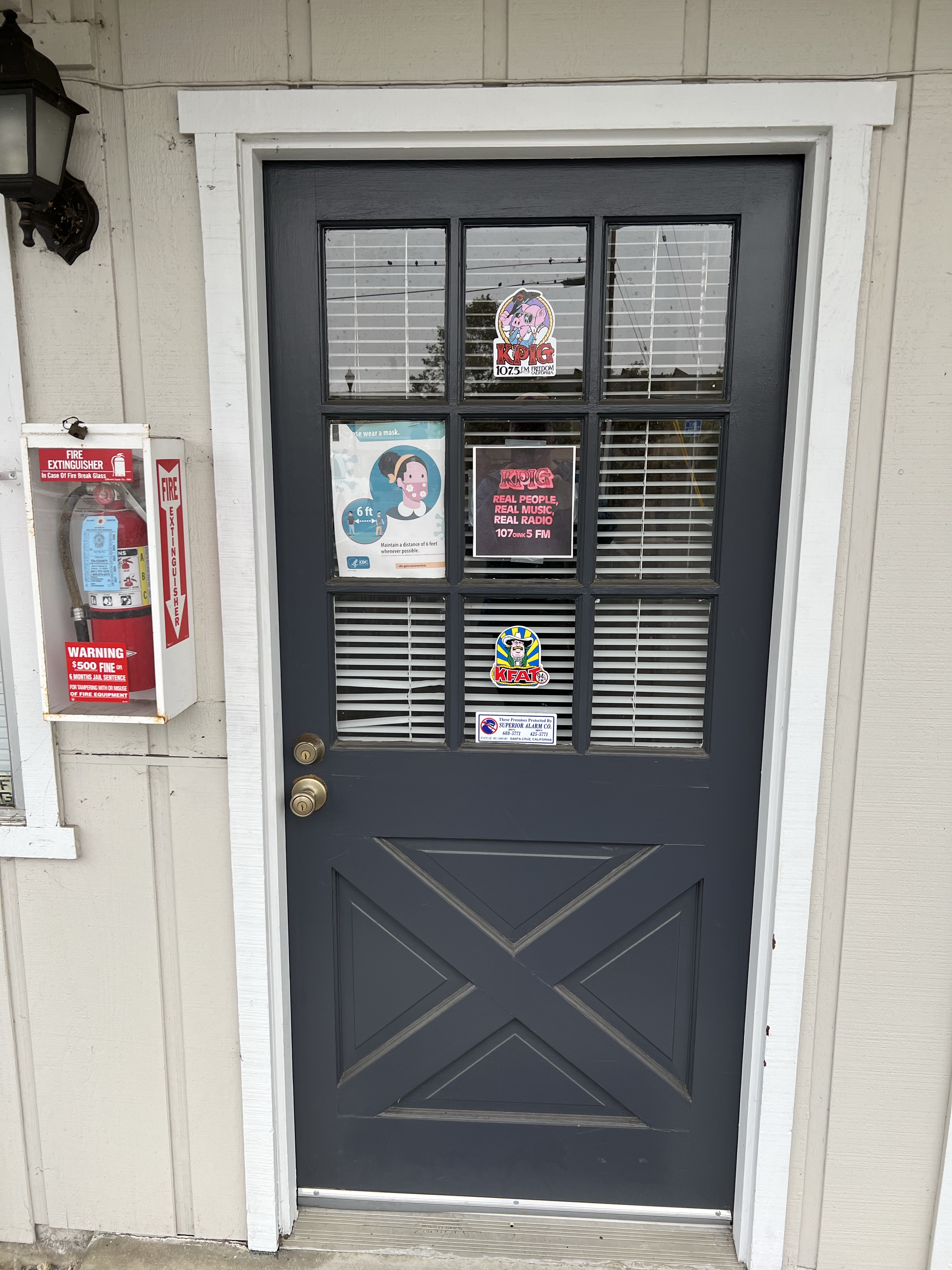
What brought me to Main Street was a bumper sticker. For years, I had seen the KPIG sticker on numerous cars and plenty of trucks. The other ubiquitous sticker in the Monterey Bay Area is for the Mystery Spot. I have always loved the design of the sticker,( by John F. Johnson of Teapot Graphics) of a sunglasseted swine dolfing his black hat. I wanted a sticker for my sketchbook but I have never seen it sold in local stores or on KPIG’s website. I thought maybe KPIG has a business office and I would be able to buy a sticker there. So off I went towards Watsonville.

As I drove out from my cabin, my radio was tuned to 107 “oink” 5 FM. Through my speakers was the Slickers song, “Johnny Too Bad”, a song I had first heard while watching film The Harder They Come. This is the film that introduced reggae to the world. I loved the eclectic variety of KPIG. Pig music, really, is just good music, no matter what genre. You can’t put your finger, or cloven hoof, on it, but it just seems right.

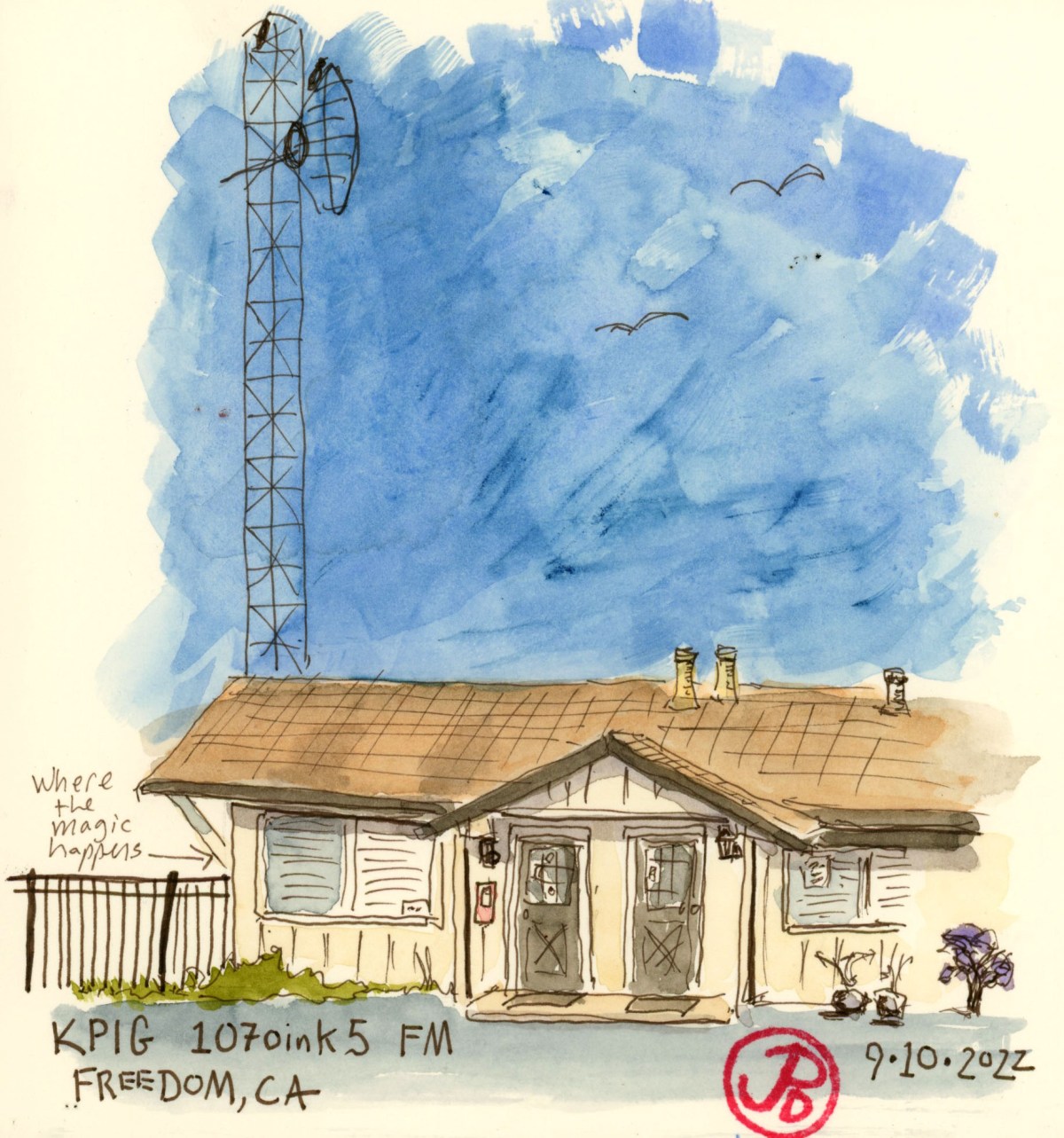
Twenty minutes later, I pulled off Highway 1 and drove down Main Street. As I neared KPIG Central, to my left, there was no tall building, crowned in tall radio towers, just a collection of businesses and a strip mall. I made a left hand turn and drove through the Dollar Tree parking lot. I came upon a complex that looked like it had once been a hotel. To my right was a single story long building that might have once been the hotel’s office. On the other end of the parking lot was an L shaped building which, at one time, housed the hotel rooms but now where businesses.

There was no sign, no ostentatious display proclaiming the business behind it’s twin brown doors, that this was the epicenter of one of the most beloved radio stations around. Somehow this seems just exactly right. The only reason I knew this was KPIG studios was that there was a sticker, the one which I was now seeking, one of the two doors. Also the sign in the window, “Beware of Attack Pig” was a swine giveaway.

What’s behind the brown door?

I parked and walked over to take few pictures of the door.

To my surprise, the door to the right opened. I was greeted by Vicki, the Saturday morning DJ. This was the woman behind the wizard! She invited me in. On the door was the phrase: “Real People, Real Music, Real Radio”. This rang true as I stood before the “real” DJ that I had just been listening to a few minutes earlier.

To my left was the studio, lined with shelves and shelves of music. In the center of the room was a deck with computer screens, a chair, and a microphone.

“So this is where the magic happens.” I said.

She gave me a few stickers and I thanked her for the music. I returned to the car and sketched the studio with the antenna rising above the former hotel.

On my ride back to Santa Cruz, I listened to the PIG and as I pulled off Highway 9 towards my cabin, Neil Young’s title track from his legendary second album came on, “Everybody Knows That This is Nowhere.”

This seemed somehow a fitting soundtrack to my KPIG morning adventure!

Image

Del Mar Theatre

On Pacific Avenue, the Main Street in downtown Santa Cruz, is an impressive example of the era of the movie palaces.

This movie palace was opened on August 14, 1936 with the feature “China Clipper”. The Del Mar has a capacity of 1,521. This means that the town of Sea Ranch, in Sonoma could all attend a movie at the Del Mar!

The sign and marquee are now shrouded in trees from the street level and the sign could use a lick of paint.

The Del was built during the pinnacle of cinema and is designed in an Art Deco Zig-Zag Moderne style. The theater was built with a stage and a 25 piece orchestra pit. This was a space designed for many forms of entertainment from celluloid to live theater to music.

Many notable musicians over the years, have taken the stage at the Del, including: Lionel Hampton, Duke Ellington, Jerry Garcia, and Emmylou Harris.

The imposing bulk of the back of the Del Mar as viewed from Front Street. I have always loved the mural that crowns the back of the Del.

Like many grand cinemas of the era, The Del Mar closed for a time, her vertical sign and marquee went dark.

At one time the theater was slated to be turned into a parking lot but local activists fought to save the landmark theater. The theater was renovated in 2002 then divided into three separate theaters and reopened.

It is now the grand dame of Santa Cruz Cinema whose neon sign again welcomes a new generation of movie goers.

A plaque on Pacific Avenue.
Image

Signs of the Time: Movie Palaces of the Bay Area

I was looking for a new Bay Area sketching challenge and a weekend sketch of the backside of the Del Mar Theatre in Santa Cruz provided the genesis.

As a child I remember seeing the large white building with the large words “DEL MAR” framed by one painting of a bikini clad beauty diving into water and a scene from a redwood forest on the other side. It wasn’t until I was in college that I attended a movie at the Del Mar, a cinema that my father visited many times in his youth. The Del Mar and my father share the same birth year. This provided another reason to sketch this historic building.

The backside of the Del Mar Theatre is one of the most prominent buildings in downtown Santa Cruz and a building that looms large in my childhood.

I would be sketching back in time to the 1920s, 30s, and 40s to the time when Art Deco movie palaces where prominent features in many towns and cities. These cinemas’s large neon signs illuminated the communities they served. This was the Golden Age of cinema, time before television and an eon before the rabbit hole that is the internet.

I decided to focus on the most visible part of these classic theaters: the sign and marquee. This proclaimed the name of the theater and was a neon advertisement for what was inside and what was currently playing.

I began my sketching adventure by doing research of existing cinemas that meet my timeline criteria and then putting that information into a Bay Area map (featured sketch).

I complemented the map with an inset sketch of the movie palace that is a mere 38 minute walk north through Golden Gate Park, from my city digs. This is one of the only remaining neighborhood theaters in San Francisco: the Balboa Theatre.

While the inset sketch was based on my photograph, I knew that I would be returning to the Balboa to sketch the theater in earnest.

Next I pack my sketching bag and head down to Santa Cruz to Sketch the Rio Theatre.

Image

The Road to Sesame Street Runs Through Salinas?

The two shows and film from my childhood that brings back happy memories are: Sesame Street, The Muppet Show, and The Muppet Movie. All three were the brainchild of puppeteer Jim Henson.

Henson had worked on Sesame Street but wanted to expanded towards a variety show for children and adults. American television was not interested in his new vision but they were in Britain. The Muppet Show became a huge international success and Henson wanted to take the Muppets to the big screen. This became the Muppet Movie (1979). For the film, Henson wanted to take the Muppets out of the studio and into real filming locations. And one of those locations was a mere 50 minute drive from my cabin in Santa Cruz.

That’s where my Muppet sketching quest begins!

And so it was that I headed south and then east towards the city of Salinas in Monterey County. South of Downtown Salinas, between Highway 68 and South Davis Road is the rural farming road, Foster Road.

Kermit the Frog from the Jim Henson exhibit at the Contemporary Jewish Museum in San Francisco.

This is the setting of one of the more memorable scenes in the film and it occurs during the song “Movin’ Right Along” where Kermit and his new friend Fozzie Bear are driving to Hollywood to become famous in Fozzie’s Studebaker.

Kermit and Fozzie are performed and voiced by long time collaborators Henson (Kermit) and Frank Oz (Fozzie). They are probably best known in Sesame Street as Bert and Ernie. Frank Oz was also the performer and voice of Yoda.

Kermit and Fozzie drive down a road, framed by farm fields and they come upon a large yellow bird walking the other direction with a suitcase. Fozzie asks, “Hey there, want a lift?” And Big Bird replies, “Oh no thanks. I’m on my way to New York City to try and break into Public Television.” Fozzie say, “Ahhh. . .good luck!”

Big Bird was performed by Caroll Spinney and it was great to see all three puppeteers in one scene: Henson, Oz, and Spinney.

Foster Road, Salinas, California, the filming location of Kermit and Fozzie meet Big Bird in The Muppet Movie.

At the intersection of Foster Road and South Davis Road, is the location of the scene when the Studebaker drives in circles, filmed from a helicopter above, as Fozzie sings, “California here we come/ the pie-in-the-sky-land”. Of course the irony is that they are already in California, Salinas, California. Which is 300 miles north of Hollywood.

Image

McCloud River Railroad Number 25

Out on the coast of Oregon, north of Tillamook, is a 97 year old screen queen that is still riding the steel rails.

On the northern edge of Tillamook Bay, in the town of Garibaldi, is the Oregon Coast Scenic Railroad . This is a tourist railroad that runs from Garibaldi to Rockaway Beach on former Southern Pacific rail.

The railroad has two steam and three diesel locomotives to pull the trains of tourists up and down the coast.

Morning sketch of one of the diesels of the Oregon Coast Scenic Railroad, the Great Northern EMD F7 Number 274.

In present day, the workhorse of the railroad is the Prairie style 2-6-2 steam locomotive McCloud River Railroad No. 25.

This locomotive was the last steam locomotive that the McCloud River Railroad purchased new. It was a workhorse for the lumber railroad and was featured in films most notably in Hal Ashby’s biopic of Woody Guthrie Bound For Glory (1976) and Rob Reiner’s Stand By Me (1986). In Stand By Me, Number 25 was featured in the famous train dodge scene that was filmed on the Lake Britton Bridge on the Burney Branch of the McCloud River Railroad. At the time of filming, Number 25 was on home rail.

The Lake Britton Bridge, filming of the ultimate train dodge scene in Stand By Me (1985).

Number 25 came to the Oregon Coast in July 2011 and has since headed tourist trains up and down the coast.

No. 25 having her tender filled with water, from a street fire hydrant, after a days work at Garibaldi.
The front end of 25 showing the builder’s plate.
Close up of the Builder’s Plate: Number 25 was build in by ALCO in Schenectady, New York in 1925.
Image

The Johnston Ridge Observatory

Most visitors who want to get close to Mount St. Helens, drive the 48 miles on the Spirit Lake Highway to the Johnston Ridge Observatory.

Here you are a mere 5.5 miles from an active volcano. This is well within the former Red Zone which was restricted to visitors in the winter and spring of 1980. Only certain people where allowed into the Red Zone and one of those was David Johnston, a volcanologist, who was there to monitor the volcano.

Johnston was really not supposed to be there the morning of May 18 but out of kindness he switched shifts with a colleague who was busy meeting with some foreign graduate students.

At the time of the eruption, Johnston was 30 years old and he had been working as an volcanologist who specialized in the study of volcanic gases and how these gases might help in the prediction of volcanic eruptions. He was at Mount St. Helens as one of the many scientists that were here to help monitor the volcano and to carefully watch the bulge on the north side of the mountain that was growing by five feet a day.

On Saturday May 17, Johnston stationed himself outside a USGS RV at a location called Coldwater II, 5.5 miles from the volcano. On the following morning Johnston made some measurements and observations and then at 8:32 AM, he radioed the USGS headquarters in Vancouver, Washington: “Vancouver, Vancouver, this is it!”

This field sketch is from the approximate position of Coldwater II, the observation position of David Johnston on May 18, 1980.

This was the last radio transmission from Johnston.

At 8:32 AM there was a 5.1 magnitude earthquake under the volcano causing the north face to fall away from the mountain causing the largest landslide in recorded geologic history. The avalanche travelled 14 miles before coming to a rest. This uncovered the over-pressured core of the volcano, releasing ash, magma, and rocks, fifteen miles into the atmosphere. The eruption of Mount St. Helens was now underway.

Johnston’s body was never found. The ridge where he was on that fateful day in 1980 is now named after him.

The memorial to the 57 who lost their lives and it’s cause in the background. David A. Johnston is one of them. The memorial is a short hike from the Johnston Ridge Observatory and it is this viewpoint that is in the featured sketch.
The incredible vista of Mount St. Helens from the Johnston Ridge Observatory.
Image

The Spruce Goose

When we think of an eccentric billionaire we tend to think of Elon Musk, but for decades before, the poster child for the archetype was Howard Hughes.

Musk and Hughes both shared an interest in aviation and exploration, and both went big. Hughes went really big.

I deviated off Highway 5 to see one of Hughes’ biggest follies. I was traveling to the town of McMinnville, Oregon (pop. 34,000), while it is only about an hour from Portland, the town seemed to be in the middle of nowhere and an unlikely location for housing the largest seaplane in the world.

This seaplane, coined the “Spruce Goose” (a nickname that Hughes always hated), is now housed in the Evergreen Aviation & Space Museum. It was nicknamed the Spruce Goose because it is the largest wooden airplane ever built. It also was given the moniker, The Flying Lumberyard, a name I think Hughes also hated.

The massive seaplane was designed during World War II as a cargo plane to ship goods across the Atlantic Ocean while avoiding the attention of German U-boats. The Spruce Goose only flew once, on November 2, 1947 in Long Beach, California. The plane was only airborne at a maximum height of 70 feet for 26 seconds. By the time of this test fight, the war was over and the plane was no longer needed.

The plane went into storage and was keep in pristine condition by a crew of 300 that were on Hughes’ payroll. They were sworn to secrecy and the aircraft was kept in flying condition but the Spruce Goose never flew again. In 1962, the crew was reduced to a fraction of it’s size and then was disbanded on Hughes death in 1976.

For many years the Spruce Goose (officially known as the Hughes H-4 Hercules) was displayed in a dome called the Spruce Goose Dome in Long Beach, California from 1980 to 1992. The new owners of the dome (a small company named Disney) felt that the oversized airplane was not making them enough money so a search was made for a new home for the massive airplane.

The new home was found in Oregon and the Spruce Goose was disassembled and shipped by barge, train, and truck and after a 138 day and 1,055 mile journey, the longest distance the H-4 ever travelled, the Goose arrived in McMinnville, Oregon.

The Spruce Goose is so massive that the museum was built around the plane and it upstages all the other aircraft on display beneath it’s massive wings. Sketching the H-4 proved to be a real challenge because you cannot get far enough away from the plane to capture it in it’s entirety. So I had to sketch it in pieces: the front (featured sketch) and the tail.

I could barely get three of the eight engines into one photo of the Spruce Goose. This airplane is massive!

Image

The Panorama From Windy Ridge

Perhaps the best view of Mount St. Helens, takes the longest drive, but the payoff is worth it.

This is Windy Ridge, five miles from the crater of Mount St. Helens. From the viewpoint you can see the U shaped peak of the volcano to the left and Sprit Lake to the right. Everything before you was part of the devastation zone.

All these year later the Pumice Plain still looks like a moonscape and Spirit Lake still has a raft of fallen logs that travels around the lake with the wind.

The matte of logs, looking here like toothpicks, from the 1980 eruption at Spirit Lake.

To capture this expansive panorama took four pages in my panoramic journal. In the field, I sketched in the forms of the landscapes with a sepia brush pen.

Mount St. Helens from Windy Ridge.
Image

Sasquatch and Mount St. Helens

Pre-1980, pre-eruptions, it seems that Sasquatch or Big Foot, was a tourist cottage industry around the slopes of Mount St. Helens.

Many a story was told around campfires on the shores of Spirit Lake about the time a creature attacked five miners near Ape Cave in the 1920s and how the miners valiantly had fought off the beast’s attacks.

What really kickstarted the Sasquatch craze was film footage reportedly of a female Sasquatch or Bigfoot walking along Bluff Creek in Northern California. The 1967 film is now known as the Patterson-Gimlin film and iconic, Frame 352, shows the creature looking back towards the camera with arms extended away from it’s dark hairy body in it’s simian lope. The famous imagine, included in the featured sketch, is the blueprint for many subsequent representations of Sasquatch. This is the iconic “Big Foot” imagine that is recognized around the world much like the Surgeon’s photo of the Loch Ness Monster. Both images have been claimed to have been faked, but there are those who will always believe.

Of course that all changed after the May 18, 1980 eruption of Mount St. Helens where seeing a live volcano was a major draw for the tourist dollar and poor Sasquatch receded into the past. More volcano tourist attractions and museums appeared around the mountain, selling tourist trinkets with imagines with erupting volcanoes, pushed Sasquatch swag off the shelves.

This cartoon, printed in the Columbian in 1980, highlights the conflict between Sasquatch and the now famous volcano.

One such tourist attraction is to be found along the Spirit Lake Highway near Kid Valley. This is the North Fork Survivors Bigfoot & Mt. St. Helens Interpretive Center. The attraction sits across the highway from the Toutle River. This has it all for the Mount St. Helens/ Sasquatch fan.

When the volcano erupted it sent mud and melted waters from glaciers and the snowpack racing down the North Fork of the Toutle River, which destroyed everything in it’s path: forest, bridges, and homes. One home that survived is the A-frame house that was half buried by the mud flow. The house is left as it was on May 18, 1980, still furnished but now filled with 200 tons of ash, mud, and silt. You used to be able to explore the interior but it has now been deemed unsafe and is now a nesting site for barn swallows.

On the other side of the parking lot is the 20 foot statue of Sasquatch, leaning on a branch for support, like someone at a wedding, who has had a tad too much to drink. This is what attracted my sketching eye and I began to render the statue in pencil and ink.

The butt-end view of the Sasquatch statue at North Fork Survivors Bigfoot & Mt. St. Helens Interpretive Center.
It’s all about Sasquatch around Mount St. Helens. This is a road I found on the south side of the mountain on my way to Windy Ridge. I had to pull over and take a photo.

Image

Zephyr Sketching (Westbound) Part 2

I really wish I could sleep on a train. Once we entered Utah, the Zephyr picked up speed and the train starts rocking and jolting even more.

It allowed me a little time to explore the AMTRAK stop at Salt Lake City. You would think that a city with a rich history that SLC would have an equally impressive station as Denver’s Union Station. The truth is that the City of Saints has not one impressive train station but two.

The current AMTRAK station is really a double wide trailer. But beyond the station, you can see the red neon sign of the former Rio Grande Station. The Union Pacific also had a separate station a short distance from the Rio Grande. While both buildings still exist, they are no longer passenger stations. The Rio Grande folded in 1987 and the UP no longer carries passengers.

I was looking forward to the stretch break at Reno because it provided enough of a break to get a sketch in (featured sketch). I sketched the Zephyr pointing west towards California as a east bound fright passes on the next track.

Here is a sketch I did last spring of the Zephyr at Reno during a stretch break.