Image

Southern Pacific’s Cab Forward

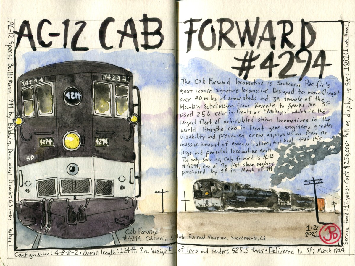
Southern Pacific’s signature, and most iconic locomotive was the 256 AC (Numbers 4000 to 4294) cab forward locomotives.

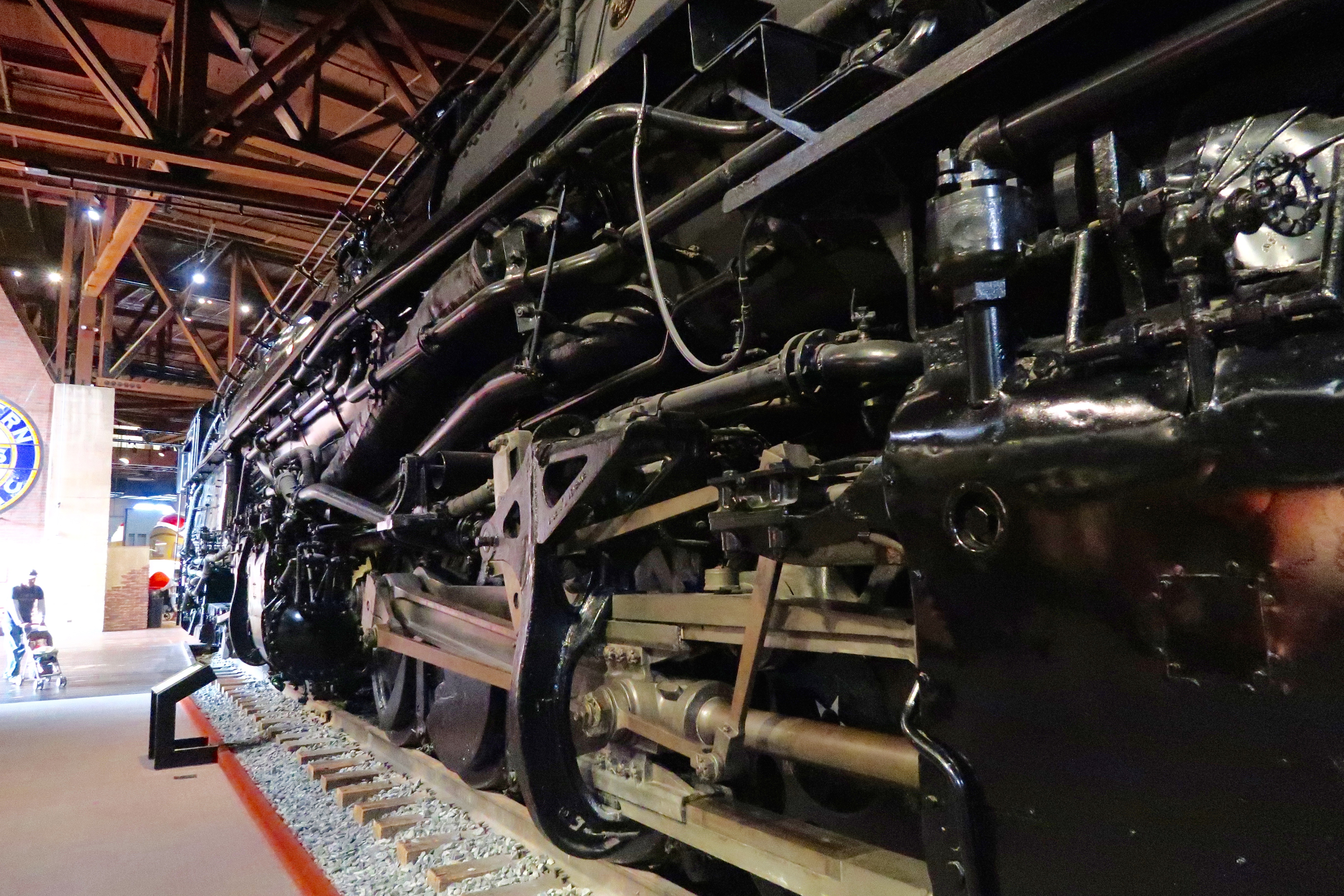
These were some of the largest and most unique locomotives in the United States. The AC-12 class is less than ten feet shorter than the largest steam locomotives ever built: Union Pacific’s “Big Boy”. The AC-12 locomotive and tender weighed more than a Boeing 747 and an Airbus A380, combined.

The reason the cab forwards were unique is that, as the name implies, the crew cab was in the front of the locomotive, like a modern diesel-electric locomotive, instead of the cab being in back, near the tender.

Having the cab in front gave the engineer and fireman unequalled views of the track ahead. But the real reason for the innovations was to conquers the steep grades of Sacramento’s Mountain Subdivision over the Donner Pass. This massive locomotives operated between Roseville, Ca and Sparks, Nv where a powerful locomotive was needed to tackle the steep grades and have the tractive effort to haul long freight trains over the Sierra Nevada Mountains. A locomotive of this size emits of lots of steam exhaust because a 4-8-8-2 was essentially two locomotives in one.

The Donner Pass route had 40 miles of snow sheds and 39 tunnels. This meant that in a standard locomotive, the crew could suffer from asphyxiation from the steam exhaust. By putting the cab forward, the exhaust stack was behind the crew and they avoided the caustic smoke, steam, and heat that these powerful locomotives emitted.

The cab forward proved to be a very successful locomotive for SP, with 256 of these engines used on it’s rail over the period of 50 years. The railroad had the largest fleet of articulated “Malleys” in the world. As a comparison, Union Pacific fleet contained 25 Big Boy locomotives.

In the 1950s, as diesel replaced steam, cab forwards spend the rest of there working life away from the mountains on the Coast Line and the Western Division. One of the last places cab forwards worked on Southern Pacific rail was the Cal-P line between Oakland and Roseville. 1958 was the last year a cab forward rode the rails, nine of these locomotives were taken out of service on September 24, 1958.

Out of the 256 cab forwards that were built, only one survives. The AC-12 number 4294 which is also the last steam locomotive that Southern Pacific ever purchased. 4294 was in service on March 19, 1944 and was taken off the the roster on March 5, 1956. She was only in service for 12 years.

While the other cab forwards were scrapped, 4294 was put in storage and then was put on static display on October 19, 1958, in front of the Sacramento train station. When the California State Rail Road Museum was opened, 4294 became the centerpiece amongst it’s collection of locomotives and rolling stock.

I was at the museum with my father in 1981 for the official opening of the museum. SouthernPacific’s GS-4 4449 and Union Pacific’s 844 (then numbered 8444) where in attendance and I will never forget when the two locomotive stood, pilot to pilot, on the track outside of the museum!

The massive running gear of the AC-12, Cab Forward. 4294 is the only surviving example of this locomotive.

The last time I have visited the museum was in November of 2017 where I did an aborted field sketch of the cab forward. There was something about the proportions of the locomotive that I did not get right. I had planned to return to the California State Rail Museum in the early Spring of 2020 but the cases of Covid-19 were growing at an alarming rate in the state and the museum eventually closed it’s doors for an indeterminate time.

So if I could not sketch the AC-12, at least I could sketch it from an image, which really is the next best thing.

Image

Santa Cruz County Birding

I’ve never been a huge county birder. County birding is keeping track of how many species seen within the boundaries of a single county.

County lines are a purely human made boundary that birds fly over but it is a fun challenge to try to see as many species in a chosen county. The three counties that I focus on are San Francisco, San Mateo, and Santa Cruz. I set the modest goal of seeing 200 species in each of the three county. Over the past year and a half I have tallied over 200 in each county.

But for Santa Cruz I wanted to see if I could become a member of the Santa Cruz Bird Club’s “300 Club”. To reach 200 took awhile and I knew to reach 300 species in Santa Cruz County would take time, persistence, patience, and luck. On the Martin Luther King Jr. three day weekend I thought I would attempt to add few birds to my Santa Cruz County list.

Now these birds were not especially rare nor were any of these lifer birds for me but they had somehow evaded my binoculars in the 831 area code. There are: snowy plover, snow goose, blue-winged teal, and American dipper.

I started my search at the very southern edge of Santa Cruz County at Pajaro Dunes. Pajaro Dunes is a private resort housing development. When I was growing up my family used to rent a house for a holiday so I have been familiar with the area from a early age. The development is gracious enough to allow access to birders.

Once I passed through the security gate I headed to the end of the road near the Pajaro river mouth after first checking the slough near the fire station for the rare long-tailed duck but the bird had flown a few days earlier and had not been seen again.

I wandered across the dunes toward the ocean looking for the small cryptic dune-plover. There were plenty of sanderlings running up and back with the tide. I checked all the flocks but no snowy plovers. I wondered how far down the beach I’d have to walk before I spotted the snowies.

I briefly checked out the backlit gull flock at the river mouth, just south of the river was Monterey County. I turned back and started walking north along the beach in Santa Cruz County. That’s when I spotted ten roosting snowy plovers which I must have walked right past.

This snowy plover is sporting jewelry. These are colored bands which helps researchers identify each individual plover. Snowy plovers are a threatened species because of habitat destruction and intensive use of their nesting grounds. Snowy ploverspopulations are declining with a recent survey estimating the total population of the Pacific Coast as 2,900.

My next stop was Struve Slough, just north of Highway One. This slough in Watsonville is a great winter hotspot for waterfowl. The waters were full of ducks, geese, and herons, but I was looking for five white snow geese. In the Central Valley, it is possible to see thousands and thousands of snow, Ross’s, and greater white-fronted geese in places like Gray Lodge Wildlife Area and Sacramento National Wildlife Refuge. But on the Santa Cruz County Coast, snow geese are a relatively rare find.

The snow geese stood out like five shining stars among the surrounding Canada geese and ducks. Another county bird was mind! Now it was time to head east to an birding hotspot: Pinto Lake.

My main target at Pinto Lake was a duck I had overlooked on previous visits. This is the blue-winged teal. Without too much of an effort I found a drake and duck.

Male and female blue-winged teal at Pinto Lake. The much larger male gadwall provides an interesting size comparison.

The final bird on my county wish list was turning into a nemesis bird for me. I had seen this bird many years ago flying downstream on the San Lorenzo River but it is has not seen on this river a while. So I headed up the San Lorenzo Valley. (I had not added this bird to my list because I have no record of the time I saw the dipper).

I was headed towards Ferndell Falls at the confluence of Zayante and Bean Creeks. This has been the American dipper hotspot in Santa Cruz County for the past ten years or so. But as hard as I tried, looking up Zayante and Bean Creeks, on over three visits, I was not able locate a single dipper. Nobody said county birding would be easy, in fact it can be a form of madness!! It just makes me even more determined to add this nemesis bird to my county list!

A nice consolation on my dipper search of Zayante Creek was seeing the world’s most beautiful duck in morning light. A wood duck pair.
I have searched for American dipper on about ten separate occasions since last summer. Maybe the 11th time’s a charm. This spread was about my July expedition up the San Lorenzo River in search of former dipper sites. The dipper is an indicator of a healthy ecosystem because they prefer clear, clean streams and rivers. This is a sign that San Lorenzo is not so pure.

Image

California Zephyr and Southern Pacific Ghosts

On a Saturday morning I drove over the Bay Bridge to the Emeryville Amtrak Station to sketch the California Zephyr Train # 6. This is the train I booked a roomette on back in April. I had to cancel the trip because of the pandemic. This route usually runs seven days a week but with the current Covid situation, it now runs just three times a week: Tuesday, Thursday, and Saturday. Unfortunately I would not be board the train, although it was very tempting!

I wanted to challenge myself to do a quick sketch because I didn’t know how long the California Zephyr would be at the platform before it departed. I guessed I would have at least 15 minutes because the engineer stepped out of the cab and walked down the platform to a get a packed lunch while the conductors assisted with boarding. I liked the ephemeral nature of this challenge because unlike a piece of sculpture or architecture, the Zephyr was not going be here for long. For this task, it helps to have a smaller journal so I went with my Stillman & Birn Delta Series 6 X 8″ sketchbook.

California Zephyr # 6, pulling into Emeryville Station. This is one of Amtrak’s longest routes. In three days time it will end it’s journey in Chicago. Note the cowboy hat in the window. This consist was a little odd because it contained three instead of two locomotives. It also did not include a baggage car, so the Zeph has no baggage.

I also wanted to work with perspective by sketching the train as it reversed toward my eyeline and vanishing point. If you don’t get the perspective right, the whole sketch can fall apart. That’s why it’s best to lay in your perspective lines in pencil.

Emeryville is the western terminus of it’s 2,438 mile journey and train number 6 pulled into the platform at 8:45 AM to take on it’s first passengers. I first established where my eye or horizon line was by holding my pencil straight out at arm’s length and closing one eye. I added the line to my sketch. I then blocked in the position of the front of the locomotive. Next, I added the vanishing point on the eyeline. This is where all the lines of the receding train converge. Now it was about adding shapes and details and then inking the sketch before the Zephyr departed at it’s schedule time of 9:10 AM.

Eastbound California Zephyr heading out towards the north and eventually climbing out of the Sacramento Valley up into the Sierra Nevada Mountains towards the legendary Donner Pass. On the platform, wearing a red coat, is a fellow train nerd. In three days and 2,438 miles later, the Zephyr will end it’s journey in Chicago.

After the California Zephyr departed, right on time, I headed south into West Oakland to take a look at the old station that Emeryville Station replaced. This is Oakland’s 16th Street Station.

The current building was designed by architect Jarvis Hunt in a Beaux-Arts style and completed in 1912. It was Southern Pacific’s main passenger station in Oakland. Passengers could take ferries from Oakland Pier to San Francisco, which was two miles away.

Once the Bay Bridge was built, in 1936, it put an end to ferry service and passengers then could take buses over the bridge to get into San Francisco. In 1971, Amtrak took over passenger service from Southern Pacific.

On October 17, 1989, the Loma Prieta Earthquake struck, severely damaging 16th Street Station. The earthquake also damaged the Cypress Structure, which was parallel to the railroad tracks. 14 blocks of this double deck freeway structure, collapsed or was damaged starting at 16th Street and heading to the MacArthur Maze. In total, 42 people lost their lives here. The most in any single location.

In the 1990’s, the rails were removed to make way for the construction of the 880 Freeway which replaced the Cypress Structure and 16th Street Station was left marooned without rails. The station was closed on August 5, 1994.

The abandoned 16th Street Southern Pacific Station. This was once the terminus of the superliner, the City of San Francisco.

From 16th Street Station I headed two miles to the Oakland Pier. This was once the busy hub of Southern Pacific’s Western Division. Oakland Pier was one of the busiest rail terminals in the country handling 763 trains a day and 56,000 passengers in a 24 hour period.

To control all this rail traffic, the Oakland Pier Control Tower made an average of 1,900 switches in a day! The majority of railroad tracks are now gone and the Oakland Pier is busy with shipping and truck traffic. The only reminder of this busy railroad hub is the remaining control tower.

The massive Oakland Pier interlocking control tower. The two poles to the right were used for “hooping up” orders, which was a way to pass orders to a train in motion. Using these poles to transfer train orders meant that the train did not have to stop to pick up orders. The tall pole was either for the engineer or fireman and the shorter one was for the conductor in the caboose.
Image

The City of San Francisco, 1952

January 12, 1952. Milepost 177, Yuba Pass.

The snowfall in January of 1952 on the western edge of the Sierra Nevada Mountains was relentless. By mid-January, Highway 40 was closed. There was no way to drive from Sacramento to Truckee or Reno without a huge detour.

The winter storms during the winter of 1951-52 dumped 65 feet of snow on Donner Summit. Southern Pacific took pride in keeping the line open over Donner Pass, even in the winter.

Donner Pass is one of the snowiest places in the Lower 48 with an average snow fall of 411.5 inches of snow each winter. According to the report, Donner Summit Snowfall and Snowpack 1879-2011, there have been four times, since 1880, the snowfall on Donner Summit has exceeded 775 inches, and on two occasions the snowfall has exceeded 800 inches: in 1938 and 1952.

Southern Pacific had an arsenal of snow fighting equipment, including plows, flangers, and spreaders but their ultimatum snow fighting weapon was the rotary plow. They used this plow when the ordinary plows failed to clear snow from the tracks so the rotaries had to be called in to finish the job.

The railroad had always kept the line open, until January, 1952. Heavy snowfall will temporality close the line but so will an avalanche.

The story of the stranded Southern Pacific streamlined passenger service, the City of San Francisco seems to come out of an Agatha Christie novel. Think Murder on the Orient Express without the murder.

Into the snowy conditions, at just after 10 AM, the westbound City of San Francisco No. 101 headed out of Norden, Ca to make the slow descent, down into the Sacramento Valley on January 12, 1952. The 15 car train was headed by three Alco PA locomotives, decked out in the red, orange, and black of the Daylight paint scheme.

The train was several hours late because of the snowy conditions. As it rounded Smart Ridge on track #1, the train was stopped in it’s tracks, blocked by a snow slide that covered both tracks. The slide was a quarter of a mile wide. The engineer tried to back the train up but the City of San Francisco was trapped by snow on both ends.

At milepost 177, between tunnels 35 and 36, the City of San Francisco became stranded with 196 passengers and 30 crew members aboard. The passengers and crew would be stranded here for three days and the City of San Francisco would be stuck here for six days.

A photograph of passengers leaving the City of San Francisco behind to hike down to Highway 40 and the cars that would take them to Nyack Lodge.

Once the train had become stranded, Southern Pacific sprung into action to try and free the City of San Francisco and rescue those aboard. Rotary plows where sent up from both Roseville and Truckee in a attempt to clear the line and reach the disabled train.

Over the next three days the rescue of the City of San Francisco continued on with the use of rotary plows pushed by cab-forward Mallet locomotives, cars, trucks, helicopters, dog sleds, and Tucker snowcats. The rescue effort would claim two lives and damage rail equipment.

On the first day, the passengers took it their stride with the belief that the ordeal would be over soon. But as the train lost power and with in the heating system, things seem to worsen. The water system aboard the passenger cars froze taking the toilets out of commission. And they were also running low on food.

On the afternoon of the fourth day they were able to get all the passengers to hike down to Highway 40 which had been plowed clear up to Yuba Pass. They were driven by private automobiles to Nyack Lodge. After warming themselves ay the lodge’s fire place, the passengers were then put on a special train that took them down into the valley where they arrived in Roseville just before midnight.

Almost four days late, the train pulled into it’s final destination, just before 4 AM, to the city of Oakland. Oddly enough the City of San Francisco does not go to the city of San Francisco.

On point for the City of San Francisco on January 12, 1952 was an ALCO PA number 6019. Southern Pacific bought 52 PAs. While these locomotives are railran favorites, they proved to be a maintenance nightmare and SP later scraped the locos.
Image

Rotary Snowplow: Workhouse of Donner Pass

Work on the railroad does to stop for weekends or holidays. And it certainly does not stop for inclement weather.

Some of the deepest snow can be found on the western slope of the Sierra Nevada Mountains and at the summit of Donner Pass. This was the same pass that turned away members of the doomed Donner Party in the Winter of 1846. This pass would not defeat the Southern Pacific Railroad from crossing the pass.

To keep the pass open the railroad, when spreaders and flangers failed, SP used their most powerful snow fighting weapon, the rotary snowplow.

The rotary plow was invented by a dentist in Toronto, Canada in 1869. The plow consists of a circular sent of blades that spins. The rotary plow is not self-propelled but is pushed by a locomotive or most likely locomotives. As the spinning blade cuts through the snow drift, the engineer can control which side of the track the chute, behind the blade assembly, throws the snow. Left or right.

Not much has changed with the design of rotary plows save for powering the prime mover. All early rotaries where powered by steam but they were later converted to diesel or electric power. In fact, most of the current fleet of rotary plows, used by Union Pacific, where built in the 1920s or 30s although they have been retrofitted and rebuilt since then.

The current rotaries still use a steam generator to help prevent some of the moving parts from icing up and seizing.

Most railroads use flanger or spreader plows but these plows meet their match when trying to push heavy snow from tracks. This is where the rotary plow has the distinct advantage. It does not need to be pushed by force, instead the rotating blades cut through snow like a hot knife through butter. And the rotary can throw snow away from the track.

The downside to rotary plows is that they are expensive to maintain. And depending on snowfall, the plows may not be put into service every snow season. It may be even ten years before the rotary is called into action. The plows are also labor intensive to operate with an average crew size of 12. The standard consist of a Southern Pacific rotary train would consist of two rotary plows (one on each each so they can remove snow in both directions), a B Unit for each rotary to supply electrical power and air pressure, and two or three locomotives.

As a result, most railroads have gotten rid of their rotaries and many have been donated to serve as static displays. Three former Southern Pacific plows are on display. One in Roseville, Truckee, and Sacramento, at the California Railroad Museum.

A very interesting sign at the Union Pacific (formerly Southern Pacific) rail yard in Roseville. I wonder if before this sign was installed, the Roseville Police got many calls about runaway locomotives!

What’s interesting about the rotary plow on static display at Roseville (SPMW 7221) is that it is near the tracks at the Union Pacific rail yard. The rotary was donated to the City of Roseville by Union Pacific in 2014. This is fitting because Roseville is where Union Pacific’s rotary plow fleet is based. As I looked down the tracks toward the rail yard, I noticed, on the far side where two rotaries.

Roseville has been a major division point on the Southern Pacific railroad. At it’s height, during the age of stream, the Roseville yard contained two roundhouses. Roundhouse No. 1 was a 32-stall roundhouse and Roundhouse No. 2 was specially built to house the larger Mallets (4-8-8-2) know as cab forwards. The turntable was large enough to turn these massive locomotives. These locomotive were reversed so the crew rode in the front and the exhaust behind them. This was to avoid asphyxiation in the long snow sheds over Donner Summit.

Union Pacific is one of the few Class I railroads that keeps a rotary fleet and they have the biggest fleet in America with six plows.

Two of Union Pacific’s six active rotary snowplows SPMW # 222 and 207.

The winter of 2017 was the third snowiest winter in recorded history on Donner Pass. The Union Pacific rotaries where put into use to clear the 13 feet deep snow to keep the line open between Roseville and Truckee.

Here is footage of rotaries at work at Donner Pass in February 2017. Credit to Jake Miille Photography.

Head on view of SPMW 207 at the Roseville rail yard. This provides a view of the circular, rotating blade that cuts through snow. Number 207 awaits the call to head up towards Donner Pass to clear the line of snow. Number 207 was built in 1926 and has since been upgraded. The “SPMW” stands for “South Pacific Maintenance of Way”.
Image

Railroad Grade Crossing

When it comes to train vs car, the train always wins.

In 2019, there were 2,216 collisions at railroad grade crossings. There are about 200,000 grade crossings in North America.

This number would be much, much higher without the safety equipment at the point where roadway and railway meet.

A grade crossing is where an automotive road crosses a railroad track (usually at 90 degrees). All crossings are required to have a least a sign or crossbuck, the “X” sign that reads “RAILROAD CROSSING”.

At heavily used roads and railroads, the crossing may have flashing lights with a warning bell and a gate. The grade crossing at Woodruff Lane in Marysville (featured sketch) has all the bells and whistles in grade crossings. No car wants to get in the way of a Union Pacific freight train.

In a later post about railroad semaphore, I noted that a freight train can take over a mile to come to a stop so if a car pulls in front of a train traveling at 55 miles an hour, even if the engineer applies the brakes, the car is toast.

With that in mind, a flashing, clanging, gated contraption makes a whole lot of sense.

And common sense tells us that when the warning lights are blinking or the safety arm is down, we should stop, no mater how much we may be in a hurry. It is odd that some motorist choose to ignore these warning signals and try to “beat” the train, usually with fatal consequences.

There are quite a few videos posted on youtube to demonstrate what happen when trucks and cars meet a fright train. Here is one such compilation:

You will never win with a game of chicken with a freight train.

A series on railroad grade crossing signs in Santa Cruz.
The grade crossing on the UP line from Marysville to Oroville. The approach from the other side is blind hence the cantilevered signal to the left. This grade crossing has about everything to make it as safe as it can be.
Image

Santa Clara Control Tower

I have been sketching a few of the remaining Southern Pacific water towers in California but I had yet to add a control tower to my sketchbook.

There are about nine Southern Pacific interlocking control towers still in existence in California and 16 are still in existence on the former SP system. These control towers where once ubiquitous on America’s railroads at busy junctions or rail crossings. Interlocking control towers centralized a group of signals (semaphore and lights) that were controlled by an operator to control the rail traffic by communicating different orders: proceed, caution, or stop. Think of it like a traffic signal for trains.

The Santa Clara Southern Pacific Interlocking Control Tower was built by SP in 1926 and put into service in 1927. The tower was in continuous use for 66 years at this very busy junction of the Coast Line and the Western Division. In the 66 years of operation, many trains, both passenger and freight, passed by. The famed Coast Daylight sped by the tower, stopping to take on passengers in San Jose.

The tower was in use until July 17, 1993 when the control of all switches and signals were moved to a centralized control center in San Jose.

A Southbound Caltrain pulls into Santa Clara Station on its way to the end of its run in San Jose. To the left is the restored control tower. On point is locomotive 915 “South San Francisco”.

Santa Clara is a busy junction where the Coast Line and the Western Division meet. It is busy today with both passenger and freight traffic. The passenger trains that stop or pass this way are Caltrain, Capital Corridor, the Altamonte Corridor Express (ACE), and the Coast Starlight. Four main line track pass Santa Clara, tracks to the northeast are used by Union Pacific for freight. The other three train a primarily used for passenger service with some routes turning off here to head north, on the east side of the Bay, towards Oakland (the Western Division).

A northbound Caltrain passes the control tower as it pulls out of Santa Clara Station heading toward San Francisco. This consist is being pushed by locomotive 905 “Sunnyvale”, an EMD F40PH-2CAT.

Sketcher’s Folly: Oops I did it again. I made a sketching mistake. In my sketch of the California Theatre in Dunsmuir I left out an “I” and now I made the egregious mistake of misspelling the county of my birth: Santa Clara. What next? Misspelling my own name?! Well at least I’m making new mistakes!

Image

Lifer Drought Ends: Least FC

My world life list has been hovering around 1,647 species for a long time now. I was hoping to break 2,000 with a planned trip to Peru but of course it was canceled due to the global pandemic.

The pandemic also meant that I have not gotten out to bird across the country or the state as much as I would like. It is great to get out and be amongst nature looking at birds but sometimes when it is a rare species that has been reported, social distancing becomes a real issue as more and more birders show up to a certain site looking into the nearby bushes.

When I found out there was a least flycatcher being seen in the Presidio I rushed over hoping to get a glimpse of it before sunset. I whiffed on the flycatcher, missing it by about an hour. But I was determined to try again the following morning.

I was in place by quarter to nine the following day. I was soon joined by two other birders. A least flycatcher in California is a rare bird! This is a flycatcher that is normally found on the east coast and it is an Empid, a genus of small flycatcher that can be notoriously hard to distinguish from one another. Some call only be told apart by song.

Within the next hour birders reached critical mass at eight.

To pass the time there was plenty of passerine action and a few raptors too. A white-throated sparrow was foraging with golden and white-crowned sparrows. Another birder called attention to the continuing yellow-bellied sapsucker high in the eucalyptus trees. This woodpecker is considered rare in California. A stunning adult red-shouldered hawk was perched above, warming itself and preening in the morning light.

An Adult RSHA, squinting into the morning sun.

After an hour’s wait, by about 10 AM, a birder informed me that they had the flycatcher further down W. Pacific Ave. So I headed down and seven birders where looking into the forest edge. I followed their gaze and got on the least flycatcher!

This was a very active bird, hawking insects on the wings and occasionally landing on the ground to capture prey. The least flycatcher forages low to the ground, which can help with identification.

The diminutive least flycatcher, looking down for insects to catch.
Image

Railroad Semaphore Signal

Semaphore is one of the earliest signal systems adopted by railways in England. It was and, in some cases, still is, used on railways around the world.

Semaphore went into wide use in England in the 1840s. Railroad semaphore is a signal that tells the engineer or engine driver that the line ahead is clear or whether the engineer should slow down or stop the train. This is an important safety device that prevents trains from colliding.

Trains, unlike cars, take a longer distance to stop. The average length of a freight train is between one to two miles and if that train is traveling at 55 miles per hour it would take about a mile or sometimes more (depending if the consist was empty or fully loaded) for the train to come to a complete stop. Therefore semaphore signals are essential to let the engineer know what dangers may lay down the tracks or around the bend.

These signals vary in design but they basically have a flag arm or blade that conveys a signal to an approaching train. The arm is positioned straight up, at a 45 degree angle, horizontal, or straight down. The blade is most often painted red with a white strip.

By the 1870s, the semaphore signal was in use by most railroads in the United States.

Later designs added signaling lights (red, yellow, green). Eventually the blade was dropped in favor of signaling lights alone. Now the majority of semaphore signals are gone on the rails of the United States’ main lines.

There still are a few semaphore signals in use in the United States such as on the BNSF’s Glorieta Subdivision in New Mexico. This route is still used by the Amtrak route the Southwest Chief (Chicago to Los Angeles).

The anchor for the sketch was a field sketch I did of the semaphore signal at the Colma History Museum. One of the things I really love about sketching is that you continually learn about the things you are sketching and just doing the sketch of the semaphore signal maybe made me wonder about its origins, designs, and its current status. The remainder of the spread is the byproduct of that wonder.

The layout of this spread has a satisfying and balanced feel. You have the high and low vertical elements of the semaphore signals in “stop” position and the use of triads. I would like to say that I planned this out by doing a pre sketch but this spread developed organically over time. The human eye, at least my human eye, likes repeated patterns and balance. And sometimes these designs happen without cognitive thought. It’s like each element of the sketch falls in place finding it’s own angle of repose.

A semaphore signal at the Colma History Museum. The signal is in the “Stop” position.
Two semaphore signals in Niles Canyon near the Sunol Depot. This shows off two different styles of semaphore blades, square and fishtail.
Image

Southern Pacific Water Tower: Coyote

There are two Southern Pacific water towers remaining in the Bay Area, one in San Jose (near the passenger station) and one further south on the Coast Line in Coyote.

I headed to Santa Clara County, the county of my birth, to the Valley of Heart’s Delight (Silicon Valley). The small, blip of a town that is Coyote is south of San Jose and just north of Morgan Hill.

Coyote is on the Coast Line, a 470 mile route that connected San Francisco and Los Angeles. SP’s famous passenger service, the Coast Daylight, blew through Coyote. A resident of Coyote wishing to catch the Daylight to Los Angeles had to either head to San Jose or Salinas. Coyote has a passenger station that was in service until December 10, 1958. The building still exists but is now abandoned and boarded up. At one time it was a private residence.

The abandoned Southern Pacific water tower and the double tracks of the Coast Line on the left. To the left of the tracks is the Metcalf Energy Center.

Before heading down to Coyote I stopped off at the town where I grew up: Sunnyvale. As I exited off Highway 280 and headed north on Sunnyvale Saratoga Road, I reflected, as I always do when I’m in Sunnyvale, on how much it has changed from the 20 odd years I spent here.

Along the road, there were things that where very much the same, such as the Longhorn Restaurant on the right (I don’t think I every ate here), and to the left is Fremont High School. The 1925 main building looks very much the same but according to a family friend, who is an assistant principal at Fremont, a lot of renovations are happening on campus.

The reason I turned off the highway was to see another water tower in the South Bay. This tower was not built by Southern Pacific, although it sits just north of the Coast Line. Before Silicon Valley, this area was known as the Valley of the Heart’s Delight and the valley was covered in apricot and cherry orchards.

According to the Sunnyvale orchardist, Charlie Olson, there used too be “eight to nine million” fruit trees in Sunnyvale. Now there are eight to nine hundred.

To process all the fruit, canneries where built along the railroad line. My father, after coming home from work, would put me one the back of his bike and he would ride on the same route he had just come from. He spent his working career at Westinghouse which was also right next to railroad.

During the harvest season, a favorite destination was a pedestrian bridge over the railroad. From this vantage point we could watch commuter trains come and go and also we could look down into the yard of one of the canneries. Here forklifts moved at a frenetic pace and I can still recall the persistent din of the processing plant as workers canned ripe fruit to be shipped, by rail, to the nation. At this time, in the mid to late 1970s, Sunnyvale very much had one foot in the agricultural word.

This cannery was the former Schuckls Cannery which was later bought by California Canners and Growers in 1963. It was in operation until the cannery was demolished in 1984. The year 1984 was a auspicious year in the valley, it was in this year that Apple introduced the Macintosh computer.

This was about to change as the valley and it’s orchards were slowly replaced by Silicon Valley. It is interesting that one of the valley’s sons recognized the beauty of this area but was also one of the catalysts for it’s demise. Steve Jobs, the co-founder of Apple, said, “Silicon Valley for the most part at that time was still orchards-apricot orchards and prune orchards-and it was really paradise.”

Can we say that Sunnyvale is now a paradise? Well I guess it depends on how you define “paradise’.

As I crossed over the railroad tracks as South Matilda Ave. become North Matilda, the water tower came into view.

The Libby Water Tower is all that remains of the largest cannery in Sunnyvale. Libby, McNeill and Libby opened it cannery in 1907 and by 1922, it was the largest cannery in the world.

The current water tower was built in 1965 and is shaped like a can of Libby’s Fruit Cocktail. This is all that remains of one of the biggest canneries in the valley. It is now surrounded by a business park with buildings occupied by Walmart and Raytheon.

Looking up at this water tower I can recall the sounds of the cannery working at full capacity, to can the bounty of the Valley of Heart’s Delight.

The Libby Water Tower in Sunnyvale. It has been repainted as a can of Libby’s “Fancy Fruit for Salads”.