Image

First Flights Over Aptos

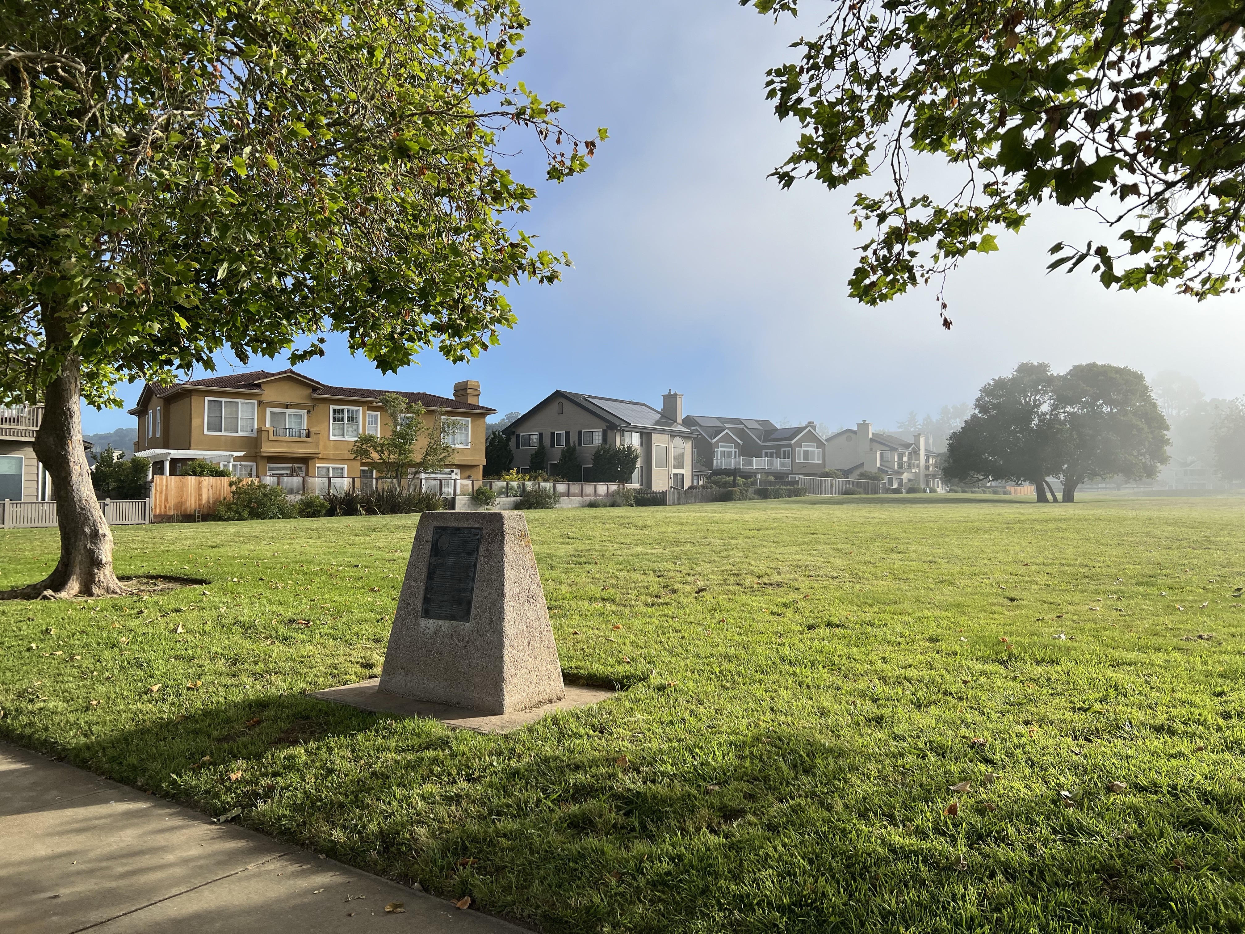
Down a cul-de-sac in a part of residential Aptos I have never explored before there is a monument to aviation at the edge of a green field.

This is what these hidden monuments are for, to reminds us of the anonymous people who have loved, lived, and lost who had come before us. The ones, on whose shoulders we stand, that have changed the world in ways we don’t understand or acknowledge.

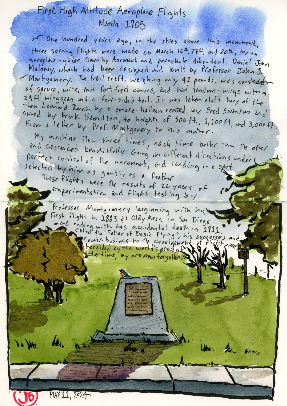
The plaque on the monument reads:

One hundred years ago, in the skies above this monument, three soaring flights were made on March 16th, 17th, and 20th, by an aeroplane- glider flown by Aeronaut and parachute dare- devil, Daniel John Maloney, which had been designed and built by Professor John. J. Montgomery.

The frail craft, weighing only 42 pounds, was constructed of spruce, wire, and fortified canvas, and had tandem-wings with a 24 ft. wingspan and a four sided tail. It was taken aloft here at the then Leonard Ranch by a smoke-balloon rented by Fred Swanton and owned by Frank Hamilton, to heights of 800 ft., 1,100 ft., and 3,000 feet. The longest flight lasted over 18 minutes and covered over 2 miles…From a letter by Prof. Montgomery to his mother…

My machine flew three times, each time better than the other and descended beautifully. Going in different directions under perfect control of the aeronaut, and landing in a spot selected by him as gently as a feather.

These flights were the result of 22 years of experimentations and flight testing by Professor Montgomery, beginning with his first glider flight in 1883 at Otay Mesa in San Diego and ending with his accidental death in 1911. Called the “Father of Basic Flying”, his successes and contributions to the development of flight were heralded by the world’s press at the time, but are now largely forgotten.

The plaque was erected in 2005 by E Clampus Vitus El Viceroy Marques de Branciforte Chapter 1797, E Clampus Vitus Capitulus Redivivus Yerba Buena #1, Hiller Aviation Museum San Carlos Ca,. Aptos Chamber of Commerce and Museum Capitola/Aptos Rotary.

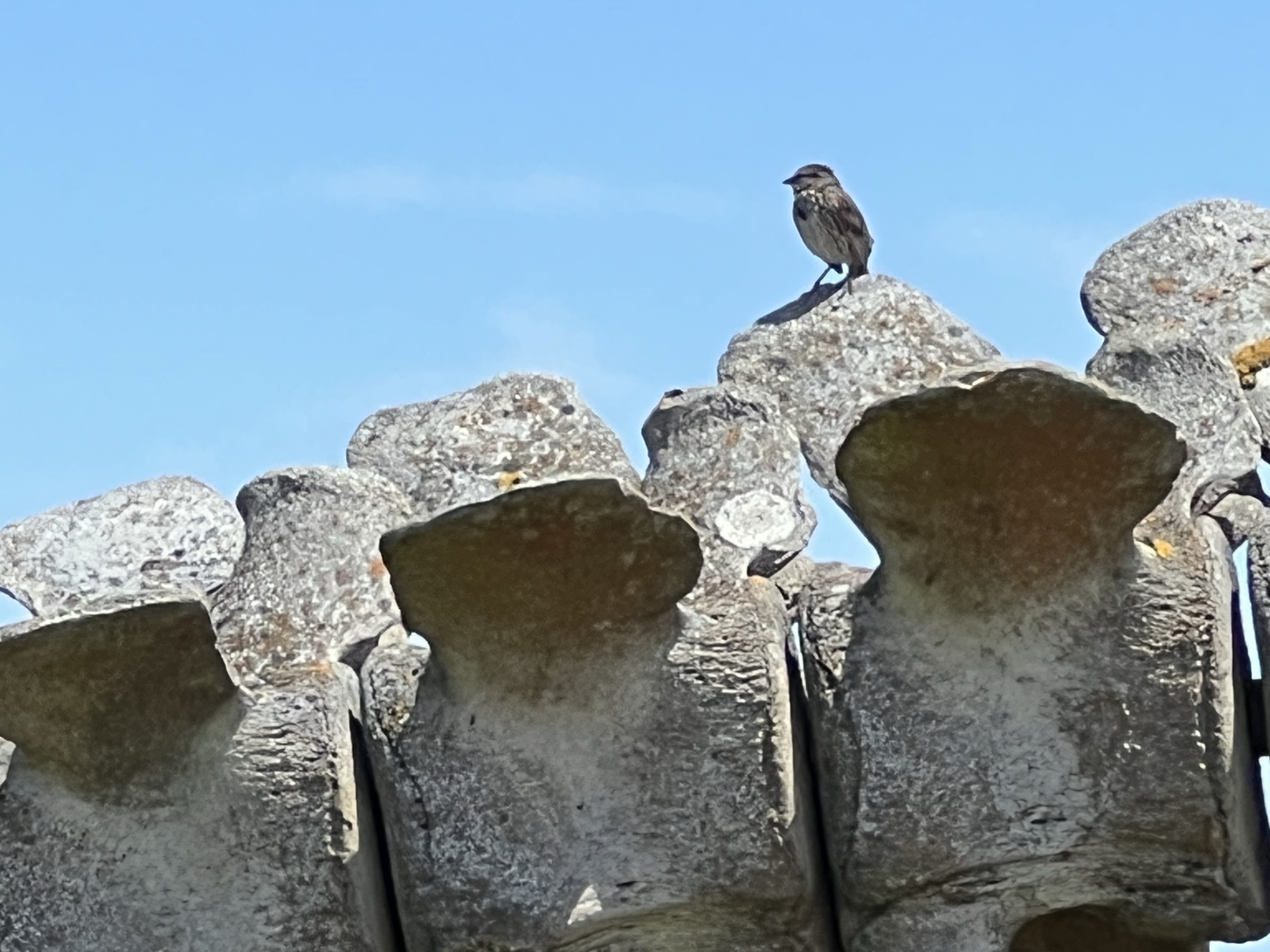
Now the monument serves as a perch for western bluebirds and the green field is used by a murder of crows for foraging. Off to the right is an owl box that a pair of red-shouldered hawks use as a hunting perch.

119 years ago, a frail, 42 pound glider soared above this field. Now it has been returned to the true masters of flight: the gulls, corvids, and hawks that effortlessly glide above.

But if you look further above you will see the great grand children of Montgomery’s passions: the modern passenger jet on final approach to SFO and SJO.

Image

Where the Rails End

Today the only way to get from Los Gatos to Santa Cruz is to drive over Highway 17. You can no longer take a passenger train. The last train ran in 1940.

On the other side of the Santa Cruz Mountains, you can board a train at the Santa Cruz Beach and Boardwalk and it will take you 6.8 miles north into the mountains to the town of Felton.

Detraining here you follow the line past the train shed and machine shop of the Roaring Camp and Big Trees Railroad and the old passenger and freight depot and then you cross Graham Hill Road and walk north on the rails toward Zayante, using the rusty rails as a guide.

The line begins to parallel Zayante Creek. The road builders used the watersheds of the Santa Cruz Mountains as a route to work up and down the summit. A good part of the Santa Cruz to Felton route parallels Santa Cruz County’s largest river, the San Lorenzo.

After a few miles you eventually come to a siding, this is the former stop of Eccles near Olympia Station Road. This was a flag stop as far back as 1901. There was once a passenger shelter (1913) and a freight platform.

The main line and siding at Eccles. The 310 foot siding was probably used to store lumber cars.

The station sign remained in place until 1942, when the station was decommissioned following the abandonment of the the railroad.

After World War II, passenger service was not resumed and the station shelter was torn down. The Eccles sign was saved and was on display at the Santa Cruz Museum of Art and History in downtown Santa Cruz.

Here’s where the Eccles station sign used to be at the Santa Cruz Museum of Art and History. It’s gone, like the rails that once reached over the Santa Cruz Mountains.

One a recent visit to the museum the sign was no longer on display.

I continued north as the siding rejoined the mainline. And after about a five minute walk, the tracks end without much ceremony. There is no bumper stop to mark the end. And one tail is longer than it’s mate, 4 feet and 8 1/2 inches away.

This is the end of the line and as far north as the tracks go.

The end of the tracks and the end of an era.

Image

Tunnel No. 8

Of all the tunnels on the former South Pacific Coast Railroad there is only one that is still in use for it’s intended purpose. That is Tunnel No. 8, the Mission Hill Tunnel.

This tunnel takes the line through Mission Hill because the town of Santa Cruz did not want the railroad to run through downtown. So they had to bore through the sandstone of Mission Hill. This meant the tunnel was prone to caving in so it was reinforced with internal redwood beams.

The tunnel is built under the Mission Santa Cruz Cemetery and in the early days, steam locomotives passing though would rattle and shake up the earth and occasionally a bone or two would fall onto the line leaving a macabre find for rail crews.

In 1985 the Southern Pacific line was purchased by Norman Clark, owner of the Roaring Camp & Big Trees Narrow Gauge Railroad, and passenger service was revived from Felton to Santa Cruz, a round trip of 16 miles.

The Big Trees & Pacific coming off of Chestnut Street in Santa Cruz on it’s return to Felton. The railroad has some of the most street running rail of any tourist railway. The train is pulling into the right of way heading towards Tunnel No. 8.
The train disappearing into Tunnel No. 8 on its way to Felton.
Image

Shady Gulch Trestle

Just up the creek from my cabin is one of the remaining wooden trestles on the former South Pacific Coast Railroad (in 1887 the railroad became Southern Pacific). This is the Shady Gulch Trestle.

Not only does this trestle still exist but is still used for rail service on the Big Trees and Pacific Railway.

Shady Gulch Trestle with the Highway 9 concrete bridge (1930) in the foreground. The dirt road to the right is the former Eben Bennett toll road. The concrete highway bridge replaced the toll road.

The original trestle was built in 1875 to span Shady Gulch. At the time, the line was built for the narrow gauge South Pacific Coast Railroad. When Southern Pacific acquired the line they rebuilt the trestle in 1905 to accommodate standard gauge.

The trestle of today very much looks like the original narrow gauge trestle of the late 19th century, sans graffiti of course.

The afternoon Felton-bound Big Trees and Pacific crossing the Shady Gulch Trestle. This tourist train tends to stop traffic on Highway 9.

My father spend his childhood summers in the cabin in the 1930, 40s, and 50s. He would tell me of the time a freight would be climbing the grade on the trestle on their way to Felton on a foggy summer’s morning. The wet track would cause the locomotive’s driving wheels to slip. And after many slips and the hyperbolic “chuff-chuff-chuff” of the stream exhaust, the train would back down the grade, sanding the track as they reversed. The freight would make another attempt, this time slowly with the sanded rails helping the drivers grip the steel. And off they went to Felton.

There is a single one car pull off on the north side of the highway bridge. I made three attempts to sketch the trestle but was foiled by a camper van that was camped out in the spot.

Was this guy going to spend the night here? On my third attempt of the day, in late afternoon, the van was finally gone and I was able to park, set up my sketching chair, and start my sketch of the trestle.

I timed my sketching time with the Felton bound afternoon Big Trees and Pacific train.

Image

Zayante: Tunnel No. 5

One of the more interesting tunnels on the South Pacific Coast Railroad is Tunnel No. 5 in Zayante.

This is one only two tunnels on the former South Pacific Coast line that is still in use, although not by a railroad.

As the railroad climbed its way up Zayante Creek it came to a granite outcrop that the builders could not go around or over so they had to tunnel through it.

Granite is stable and solid and because of that they did not have to add any interior wooden supports. When completed Tunnel No. 5, at 250 feet, was the second shortest on the line.

The tunnel was active until the Southern Pacific’s abandonment in November of 1940.

The tunnel began it’s current use in 1952 when the Western States Atomic Vault Company bought the tunnel, sealed both ends and used Tunnel No. 5 as a fire-flood-nuclear-proof storage silo, housing records (mainly microfilm and microfiche) for many companies including Disney. The silo officially opened on May 2, 1954.

The eastern portal was made the entrance to the facility and a guard shack was built (featured sketch) where a guard was stationed 24/7. We did not see any signs of a guard so we could not ask for a tour. (The facility is currently owned by Iron Mountain).

In times past, the company would allow tours inside the facility and one visitor deemed it the “most interesting dull place in the world”.

One can only guess the nearly 70 year old “secret” files that now reside in the former railroad tunnel known as Tunnel No. 5.

Peeping through the fencing toward the eastern portal of Tunnel No. 5. One of the two windowed buildings appears to be the guard shack. The parking lot now looks like an odd junk sale with junk that no one wants to buy!
The former rail bed (sans rails) looking towards Eccles and Felton and Santa Cruz.
Image

Tunnel No. 3, Laurel and Glenwood

On a historic rail sketching adventure, Grasshopper and I headed up into the Santa Cruz Mountains to sketch a portal of one of the longest rail tunnels on the former South Pacific Coast Railroad (later Southern Pacific) route.

This 28 mile route started at Vasona Junction in Los Gatos and climbed over the Santa Cruz Mountains to the beach town of Santa Cruz.

Part of this route still exists as the Big Trees and Pacific Railroad which operates a tourist train from Felton to the Santa Cruz Beach Boardwalk.

The tunnel we were looking for is the Glenwood Tunnel, also known as Tunnel No. 3. This 5,793 foot tunnel was active from 1879 to 1942. The original tunnel was built for narrow gauge but when Southern Pacific took over the line in 1887, they later converted the line to standard gauge (4 ft 8.5 in).

When the South Pacific Coast Railroad was first planned, then had to figure out how to get the road bed into the San Lorenzo Valley. To do this they had to built two one-mile long tunnels: Tunnel No. 2 (Summit Tunnel) and Tunnel No. 3 (Glenwood Tunnel).

From northbound Highway 17, we took the Laurel exit heading towards the former township of Laurel. We passed a few mountain homes and two bikers laboring up the hill as we headed down towards the former rail-bed.

We parked and headed out to a get a better look. The west portal of the Glenwood Tunnel was visible, but parts were obscured by trees and a power pole. The “private property” sign kept us at bay. Was this the best view we would get?

The not-so-great view.

I climbed up a side road, probably also private property, that parallels the rail bed, to get a better sketching vantage point. Even here, the portal was obscured by redwoods but I started a sketch anyway (which, like Tunnel No. 3, I abandoned).

Not being satisfied with the sketch I returned to where Grasshopper was sketching. His only company was a barking dog on the other side of a fence. There was a house just to our left.

A man peeked over the fence with his cup of coffee and said, “You can walk up to the tunnel if you want.”

This was the owner of the house (let’s call him “Bill”) and we had a nice conversation with him about living in the redwoods, winter storms, history, his spring-fed water system, and trains and tunnels.

We thanked Bill and walked around the chain that crossed the rail bed and headed towards the western portal of the Glenwood Tunnel. Now this was the way to sketch the tunnel (featured sketch).

Grasshopper sketching the western portal of Tunnel No. 3. Bill’s spring-fed water system can be seen on the right.
Corvidsketcher in the western portal of Tunnel No. 3.

We walked into the 1909 concrete portal. The tunnel ended in about 50 feet.

In 1940, winter storms and landslides closed portions of the route permanently. Southern Pacific made the decision to abandon the line. The major tunnels were dynamited at both ends, closing the tunnels for good. The concrete portals are all that still remain.

Now that we firmly had tunnel fever, we had to find the other side of the tunnel, the eastern portal.

Tunnel No. 3 now passes under Highway 17 so you have to cross over the highway to find the other end.

The eastern portal of the Glenwood Tunnel at Glenwood Drive.

The eastern portal of the Glenwood Tunnel is much harder to get to than the western portal. To get a comparable view you would have to scrabble down a steep hillside or trespass through a stable to reach the rail bed which now seems to be a creek bed.

So we had to make due and sketch the portal from the side of Glenwood Drive, which the concrete portal now supports.

Image

The Coastal Hoosegow

The big house, the bucket, the calaboose, the cooler, the gray bar hotel, the hoosegow, the joint, the jug, the pen, the pokey, the slammer, and stoney lonesome.

These are all slang for jail.

On my way down the coast, I did a Friday afterwork jail sketch in the town of Half Moon Bay.

On a side street that parallels Main is a small building that sits alone. In case anyone wondered what this building was, it reads “JAIL BUILT-1909” in big black letters across the top. (The jail was actually built in 1919.)

This was Half Moon Bay’s small two-cell jail. This isn’t, even with the wildest imagination, the Big House.

The jail is built of reinforced concrete on a concrete foundation, built to keep people in. Not like it’s formerly interned were serious criminals. The cost of the jail was $3,000.

The Half Moon Bay Jail reopened in 2018 as a historical museum.
The two cells and constable’s office.

The jail held prisoners until they could be transferred to the county jail in Redwood City. Locals also spent the night here having had too much fun in Half Moon Bay’s saloons.

The jail was used as a jail and sheriff’s office until 1967 where it was little used until it was reopened as a historical museum in 2018. It is the oldest public building in Half Moon Bay.

I then headed 45 minutes south on Highway One to the small town of Davenport to sketch their small jail.

This two-cell jail was built in 1914 of Santa Cruz Portland Cement, made at the Davenport Cement Plant. This small jail was built to last and looks solid for a building that is over 100 years old.

The jail housed two horse thieves from San Mateo and like Half Moon Bay, locals that had imbibed a bit too much in Davenports’s saloon.

In 1936, when the new jail on Front Street in Santa Cruz was built, the Davenport clink became redundant.

It is now a historical and art museum.

Image

Otter 841

It is nice to see sea otters along the Santa Cruz coast. Laying on their backs, bashing a mollusk to death or eating a crab, recently caught, and still alive, one foot at a time, or rolling in the kelp, belly full, and settling in for a nap.

Fresh caught crab is on the menu off of West Cliff Drive.

This marine mammal was hunted to near extinction because of their pelts. Now they are protected and have prospered on the California coast.

A five year old female, branded a “terrorist” by some in the media, has grabbed the world’s attention.

This is Otter 841.

Otter 841 was born in captivity and then released to the wild. Her mother, Otter 723 was taken out of the wild because she was habituated to people and was approaching kayakers begging for food. It was apparent that Otter 723 was being fed by humans.

While in captivity they realized that Otter 723 was pregnant and she soon gave birth to our troublemaker Otter 841.

841 was released to Monterey Bay where for four years she swam under the radar.

Starting in June of 2023, 841 has become a surfboard pirate. The otter has been observed and photographed jumping up onto surfboards, dislodging it’s surprised rider, in the popular surf spots of Steamers Lane and Cowells. On one occasion, 841 took some bites out of a surfboard.

Is this Otter 841? On the otter’s left flipper is a light blue tag with a three digit identification number.
Surf at your own risk! Surfers keeping an eye on the infamous otter.

The powers that be decided that 841 should no longer be in the wild and attempts were made to capture 841 employing the cunning use of a surfboard. They tried and tried again but they could not capture the piratical otter.

And as of publishing, Otter 841 still swims free off the coast in Santa Cruz.

Don’t mess with nature because nature usually wins.

Image

The Former Whales of Long Marine Lab

One joy of sketching is to return to a previous subject but sketch it from a different perspective. Such is the case with the whales of Long Marine Lab in Santa Cruz. (Former cetaceans, that is.)

Long Marine Lab is part of the University of California at Santa Cruz (UCSC) and is a research and educational facility for marine biology. The campus also features a small aquarium (the Seymour Marine Discovery Center) that is open to the public. The biggest draw for me is the biggest creature that ever lived on Planet Earth: the blue whale. The Discovery Center has an incredible blue whale skeleton on display flanking one side of the museum.

I had sketched the massive blue whale skeleton and the smaller gray whale skeleton before but I wanted to sketched them in a different way. For the blue, I stood directly in front and sketched it head on, as if the largest creature on Planet Earth was swimming towards me.

I have been lucky enough to see blue whales in the wild from pelagic boating trips. Most of these trips have been in Monterey Bay. I remember the first time I saw this massive cetacean on a trip out of Monterey Harbor with my father in the late 1980s. My high school biology teacher at the the time didn’t believe blue whales could be seen in Monterey Bay, until I showed him the photos.

Song sparrow using the vertebrae of the gray whale for a singing perch.
Gray whale skeleton with the Seymour Marine Discovery Center on the left and Big Blue on the right.
Image

Long in the Tooth

In late May, something interesting washed up on Rio Del Mar Beach in Aptos on the shore of Monterey Bay. It was not your standard bit of driftwood, a dead marine mammal, or a piece of flotsam from Japan.

In fact the jogger who found it did not know what she found, so she took a picture of it and did what most of us seem to do nowadays: she posted the picture on social media. Someone who did know what it was saw the post and that person was Wayne Thompson, the Paleontology Advisor for the Santa Cruz Museum of Natural History. He identified the object as a tooth from an extinct mastodon!

When they returned to the beach the tooth was gone. So a search was begun to find where the molar tooth has gone through national and even international media. The efforts soon turned up the tooth. A local man saw the tooth on the beach and took it home. He saw that this was being sought after and he called the Santa Cruz Museum of Natural History.

The tooth was put on display at the museum for three days on the first weekend in June. And that is where I saw the tooth and sketched it.

The recently found mastodon molar in a box, on display for three days at the Santa Cruz Museum of Natural History. I sketched it on the second day.

When I first stepped into the museum, it was much busier than usual. In front of the mastodon display stood the man himself, Wayne Thompson, being interviewed by a local news station. He told the reporter that the tooth was probably washed down Aptos Creek during the record rains of 2023 and then washed up onto the beach. This was a big story. I was told that NPR would be visiting the museum on Monday.

Mastodons are related to the wooly mammoth and the modern elephant. The Pacific mastodon (Mammut pacificus) once roamed the land that became California between five million to 10,000 years ago. So the tooth was an incredible and rare find. In fact the name mastodon comes from ancient Greek meaning “breast tooth”, referring to the nipple-like appearance on the crown of the molars.

Mastodons disappeared from North and Central America about 10,500 years ago. It believed that the mastodon was driven to extinction by early human hunters.