A few years ago a friend, who is a Civil War enactor, told me about the men who sketched Civil War battles, as they happened! He asked if I wanted to suit up and sketch one of their reenactments.
I didn’t get a chance to go back in time and sketch a “battle” but the idea of a sketcher that followed an army and pulled out a pencil and paper when battle erupted, truly intrigued me.
The age of photography was at least 30 years old by the time of the outbreak of the Civil War. However it was not a good medium for capturing a battle. The reason for this was that the camera had to be on a tripod and subjects had to hold still because of the long exposures necessary to expose an image on a glass plate. That is why many photographs of the Civil War generals or soldiers are of seated and sometimes standing, in rigid, staged poses. The other common photographs are of the dead, after a battle (the dead hold still, really well).
A photograph of dead soldiers at Gettysburg taken after the battle. (Tim O’ Sullivan/ Library of Congress)
Photography proved to be an unsuitable medium for capturing a battle but a field sketch could be done quickly and then the field sketch would be sent back to New York and turned into an engraving, creating plates for illustrated newspapers.
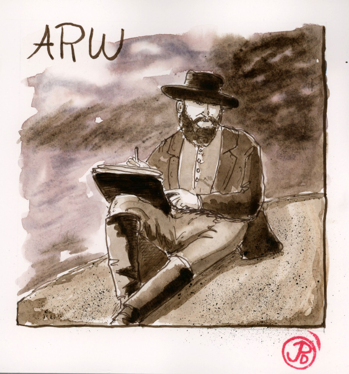
One of the most notable Civil War Sketchers was Alfred Waud. He was born October 2, 1828 in London. As an art student he studied to be a marine painter. In the end he did not pursue this style but instead he painted theatrical scenery. Waud sailed for New York in 1850 in pursuit of work.
Waud is most well known for following the Army of the Potomac and sketching every battle from the first Bull Run to the Siege of Petersburg in 1965. During this time he worked for the New York Illustrated New and then he 1861, he sketched for Harper’s Weekly.
Waud’s sketch of the death of General John Reynolds at Gettysburg.
Waud was only one of two artists to sketch the Battle of Gettysburg, the bloodiest battle in the Civil War and the turning point of the conflict. His sketches of Pickett’s Charge, on July 3, 1863, is thought to be the only visual account by an actual eyewitness.
Waud’s illustration of Pickett’s Charge showing Lewis Armistead leading his men, hat on sword. This was the fartherest advance by the rebels during the entire Battle of Gettysburg. Armistead was shot and died a few days later.
Waud’s sketch of Warren, surveying the lay of the land at Little Round Top at Gettysburg, July 1863.
“What we need to remember most of all is that the Civil War is not over until we, today, have done our part in fighting it, as well as understanding what happened when the Civil War generation fought it.” -Barbara Fields.
The Civil War. What a daunting episode in our nation’s history.
It is so daunting that it took me a long time to get around to read about it. And reading about it, takes real time and commitment. For example, Shelby Foote’s account of the war is told across three volumes and over 3,000 pages. The Civil War is the most written about event in American History. The estimate is around 100,000 volumes about out National bloodletting. The President of the Union, Abraham Lincoln, is the most written about historical figure, coming only second to Jesus. About 15,000 books have been written about Honest Abe. Where do you have the time? And where do you even start?
The impetus for me, was my late brother Greg. Greg was an educator of American History and a voracious reader of American nonfiction. One summer we decided to read a book that had been sitting on our book shelves for a while, gathering dust. It was yet another biography of Lincoln. But this one, had been hailed as the latest and greatest history of our 16th, and perhaps our greatest presidents. The book: David Herbert Donald’s Lincoln.
Over the summer we held our unofficial book club over the phone. We discussed Lincoln and his times and the events that shaped his presidency. Greg had to fill me in on many of the details of the Civil War. Now here was a huge void in my understanding of American History. I had avoided delving into the Civil War partly because of it’s overwhelming scope and breath as a subject and also because it seemed to be a blotch on our national character that was uncomfortable to face head on. How could it be that a nation called the “United” States of America be so ununited? (Sounds very contemporary I know!)
I wanted to read more about the Civil War and my brother suggested a very enjoyable read: the narrative and fictionalized historical account of the Battle of Gettysburg: Michael Shaara’s The Killer Angels.
After reading the Lincoln biography and Shaarra’s masterpiece (which inspired the film Gettysburg) I asked my brother for a reading recommendation for the best single volume account of the Civil War. I wanted to understand the times and context of the Civil War without taking a lifetime to read about it. Greg’s response was Battle Cry of Freedom by James McPherson.
I bought Battle Cry of Freedom and like any great or important undertaking, it sat on my bookshelf awaiting the first turn of it’s 909 pages. I thumbed through the pages and looked at the photos but I could not bring myself to take the first step on this long journey of learning.
Then on April 5, 2021, Greg died.
His death was the impetus to finally start reading about our nation’s greatest struggle. I spent the summer reading Battle Cry of Freedom. This masterpiece covers the causes of the Civil War as well as focusing on the people who fought it and it’s battles.
I realized that to really understand the Civil War, you had to visit some of the battlefields. And the the one battlefield that seems to rise above the others is Gettysburg, the battle that became the turning point in the war. (spoiler alert: the North won).
I planned to visit Gettysburg and a few other battlesites in Pennsylvania, Maryland, and Virginia. And before I take any trip, I do a bit of sketching.
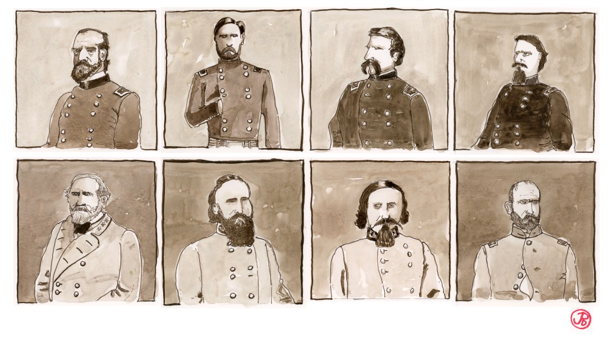
This time I want to sketch the Dramatis personae of the Battle of Gettysburg. Four from the North and four from the South.
By the time of the Civil War, portrait photography was popular and many of the generals, North and South, sat to have their portraits taken. All off my sketches were draw from these portraits.
The Portraits
The North (Left to Right):
Maj. Gen. George G. Meade, head of the Army of the Potomac. Meade became the commander of the Army of the Potomac just three days before the first battle at Gettysburg. Meade’s horse “Old Baldy” was injured during Gettysburg but survived the General to participate in the general’s funeral procession in 1872.
Maj. Gen. John F. Reynolds of the First Corps. Reynolds fought in the Mexican War become friends with Winfield Scott Hancock of the North and Lewis Armistead of the South.This Pennsylvanian was killed on the first day of battle on July 1, 1863. He was a friend and had served under General Meade.
Col. Joshua L. Chamberlain of the 20th Maine. He is know as the Fighting Professor and the hero of Little Round Top for his heroic bayonet charge. Chamberlin taught at Bowdoin College where he was not aloud to enlist, but went on a leave of absence and enlisted anyway. He is one of the key figures in Michael Shaara’s The Killer Angels. Chamberlain suffered six wounds during the Civil War, eventually dying of them in 1914. He is said to be the final casualty of the Civil War.
Maj. Gen. Winfield Scott Hancock of the Second Corps, was fighting in his home state of Pennsylvania. During the fighting in the Peninsula Campaign, he received the nickname, “Hancock, the Superb”. He was wounded on the final day of the Battle while defending Cemetery Ridge against Pickett’s Charge.
The South (left to right):
Gen. Robert E. Lee, Commander of the Army of Northern Virginia. Lee was born in Virginia in 1807. In 1829, he graduated from the US Military Academy, second in his class. He married Mary Anne Curtis and he moved into her family estate home in Arlington, Virginia, later to become Arlington National Cemetery, first opened to bury the Civil War dead. In 1861, Lincoln offered Lee the command of the U.S. Army, he refused and on April 20, 1861, resigned his commission and fought for the South. Lee was a brilliant strategist in the Civil War but the Battle of Gettysburg proved to be his Waterloo.
Lt. Gen. James Longstreet, Commander of the First Corps. Nicknamed “Old Pete” Longstreet served in the Mexican War with many of the men he would be fighting against during the Civil War. Longstreet disagreed with Lee’s tactic on the third day at Gettysburg. He was reluctant to send men forward in what became known as “Pickett’s Charge” because he believed it would fail, which was ultimately the case.Longstreet became a critic of Lee after the war.
Maj. Gen. George E Pickett, head of Pickett’s division in the First Corps. Ranked last in his class at West Point, Pickett served in the Mexican War with Longstreet. The flamboyant Pickett lead the charged on the Northern position on Cemetery Ridge loosing almost his entire division in the process. On their retreat from the charge, Pickett encounter Lee and the General asked Pickett to rally his division for defense, to which Pickett replied, “General Lee, I have no division.”
Brig. Gen. Lewis A. Armistead, came from a military family. He was a West Point drop out that learned his trade during the Mexican War. During the last day of Battle of Gettysburg, Armistead led his Brigade, hat on sword, and made the deepest advance on the Northern lines, becoming mortally wounded in the process. The wounded General was misidentified as Longstreet and under a truce flag on July Fourth, a Northern messenger encountered the very much living Longstreet letting him know that the General “would be taken care of”. Old Pete “told the messenger he believed he could take care of himself quite well”.
The Mendocino County Coast is a sketcher’s paradise with many interesting buildings, coastal views, and flora and fauna (who doesn’t love sketching coast redwoods?).
I have sketched many buildings in and around Mendocino and there are infinite subjects to sketch in this area.
In Ft. Bragg I walked out to Glass Beach. The rock formations appealed to me and I did a loose brush pen sketch from my folding sketcher’s chair (featured sketch). Sketching these rocks was recording a moment in time because the sea coast is always in a state of flux. Rocks crumble and reform, arcs collapse and the unrelenting tide shape and sculpt the coastline.
There seemed to be more common ravens in Ft. Bragg the I remember before. These very intelligent and adaptable birds have been expanding their range along the coast. As I was sketching I was watching these large corvids (the world’s largest songbirds) foraging among the rocks and seaweed like a black oystercatcher. I even slipped one in on my sketch.
I headed south to the scenic and historic town of Mendocino. Here a had a building in mind that I wanted to sketch. This building was built in 1901 by Portuguese settlers and as it turns out, it is the largest hall in the town of Mendocino. This is Crown Hall.
Crown Hall is on a side street (Ukiah Street) that parallels Main Street. The hall can be rented out for weddings and other events. The building features a kitchen, a bar, and a stage.
The stage is what really attracted me to doing a sketch of Crown Hall. This was a venue used by a legendary Northern California folksinger, Kate Wolf. She preformed at various locations in Mendocino and the last Kate Wolf recording released, Live in Mendocino, features live recordings from concerts in Mendocino County, including a concert at Crown Hall in 1982.
Kate Wolf was born in San Francisco in January 27, 1942. When Kate was 27, she visited Big Sur and heard locals playing music in their living rooms. So inspired, she moved to Sonoma County and stared writing and performing music in local bars.
Kate’s following grew in the 1980’s and she performed all around the Golden State and was even featured on the music show, “Austin City Limits” and on the radio show “A Prairie Home Companion”. In 1981, Kate released “Closer to You”, which is probably her best album featuring her own compositions. In 1983 she release the live album “Give Yourself to Love”, the title track becoming one of Kate’s most well known songs.
Sadly, Kate Wolf died at the age of 44 on December 10, 1986 after a long battle with leukemia. In her honor, the Kate Wolf Music Festival was held in June of 1996 in Sebastopol. Since 2001 it has been held at Black Oak Ranch in Laytonville, ca. The three or four day music festival traditionally ends with a cover of “Give Yourself to Love”
I included the first verse and chorus of this song to my sketch.
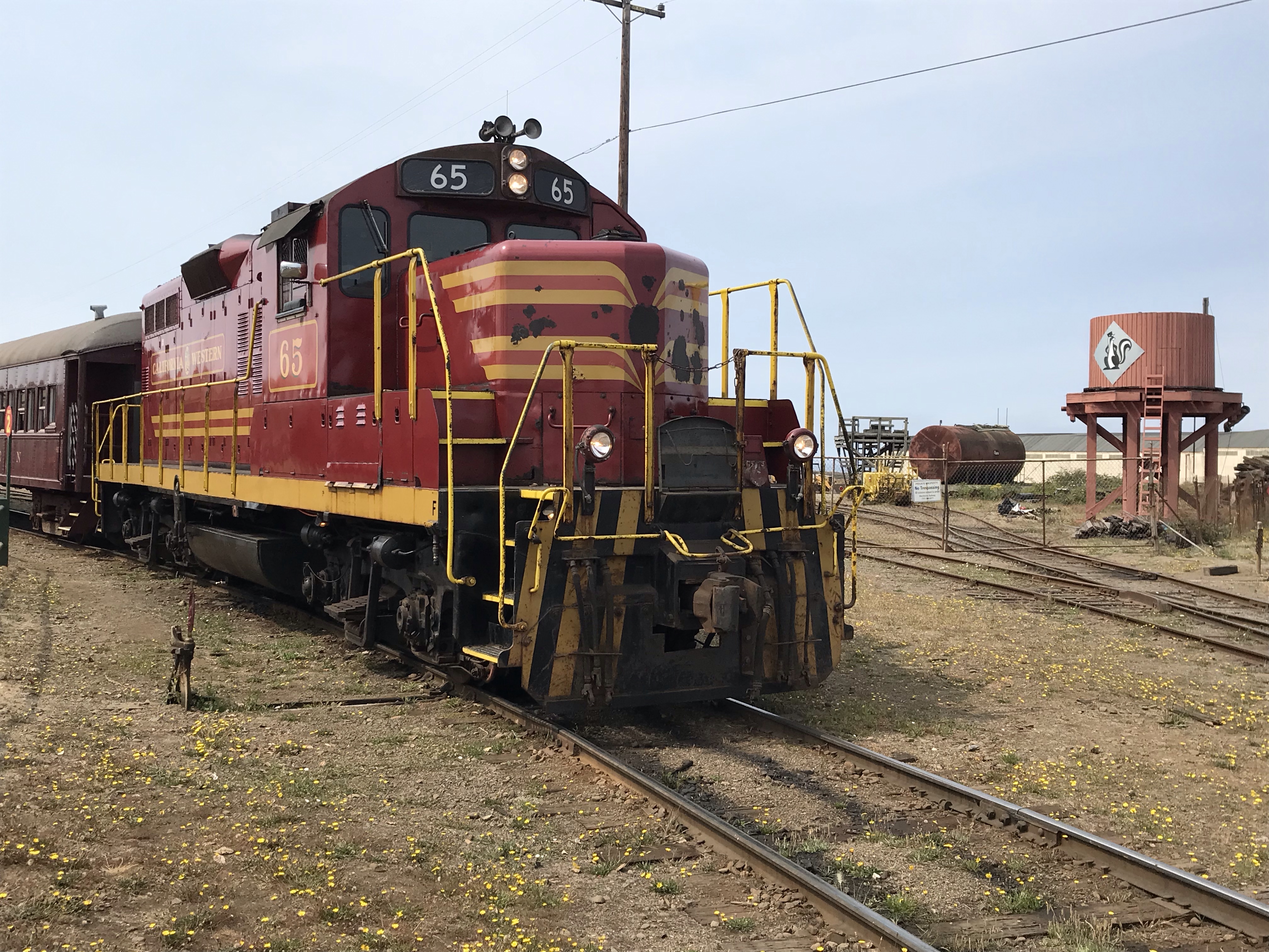
For my second road trip of the summer, I chose my base camp: Fort Bragg on the Mendocino County Coast. I knew that one adventure I wanted to experience was a ride on the Famous California Western Railroad, also known as the Skunk Train.
The Skunk Train runs from Ft. Bragg to Willits, a train journey of 40 miles. A round trip of seven hours. The former logging railroad crossed 30 bridges and trestles and travels through two long tunnels.
The Skunk at Ft. Bragg. The water tower is for No. 45, a Mikado steam locomotive. Our train (No. 65) was pulled by a former Southern Pacific GP9 diesel built in 1955 by EMD.
The Skunk is a poor reflection of its former self because of the April 11, 2013 partial collapse of the 1,200 foot Tunnel No. 1. The tunnel was built in 1893 and it is in an area known for hill slides. This means that the Skunk Train only runs from Ft. Bragg to Glen Blair Junction, a distance of 3.5 miles. It seems like just when the train gets going, it stops 30 minutes later.
The railroad has also been without an operable steam locomotive. The 2-8-2 No. 45, was built by Baldwin Locomotive Works in 1924. The locomotive is currently being restored and may be once again under steam in the upcoming year.
The end of the line, for now. Plans are underway to open the line in about a year. In the background is the western portal of collapsed Tunnel No. 1.
It is a pleasant ride on the “Pudding Creek Express”, although “express” is hyperbole of the highest order! I chose to get out and explore the area and then catch the second train back to Ft. Bragg. There are a few hiking trails and I hoped to get in a few sketches before the train returned, so I had time to sketch and paint and had extra time to let the paint dry!
I started by sketching the caved in western portal of Tunnel No. 1. The tracks were covered in dirt and rocks filled the entrance. Vegetation was growing up, almost threatening to cover the portal. A train has not passed through here in almost eight years. A maintenance worker told me that they hoped to have the tunnel open in about a year. I’m not sure they could move a mountain but I’m sure that have the funds and the manpower to clear a tunnel.
Motor car M-100 at Willits, facing west towards Ft. Bragg.
On the following day, on a flight of fancy, I decided to drive to Willits to see the eastern end of the line. From Coastal Ft. Bragg to Willits was about an hour with temperature difference of about 30 degrees! I pulled up to the beautiful redwood station in time to see the eastern Skunk pull into the station. The Willits train is a two hour,16 mile, round trip. This trips travels to the highest point on the line (1,740 feet) and travels past the “”Wolf Tree”, a large coast redwood.
The line at Willits is isolated from the Ft. Bragg side of the railroad because of the collapse of Tunnel No. 1 so what ever motive power and cars are what ever was here, prior to April 11, 2013.
On the Ft. Bragg side of the line sits the Motor car M-300 (sketched in the featured sketch). These gas powered cars where used for passenger service in 1925. These motor cars gave the railroad it’s name, because the locals named the cars “skunks” because, “you can smell ’em before you can see ’em.”
The M-100, which is on a siding in Willits, was built by the Edwards Rail Car Company in 1925. It is still operable and used when ridership is down instead of using a diesel with passenger cars.
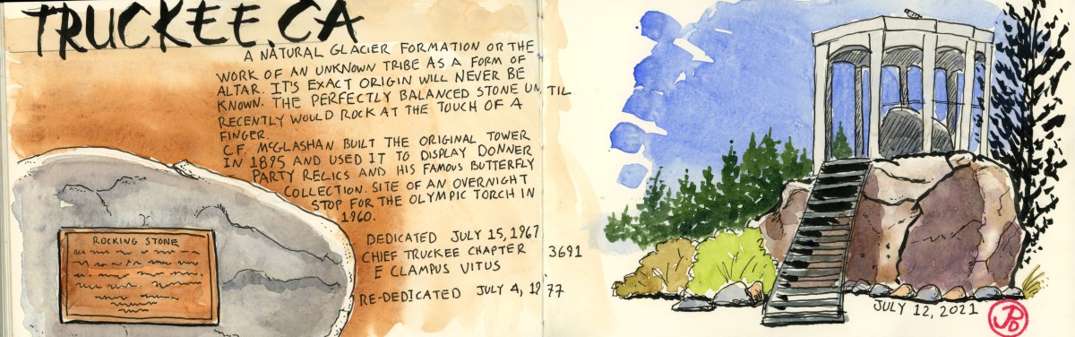
When I was a kid, I remember my father taking my brother and I to see one of the big tourist sites of the Sierra Nevada town of Truckee: the famed Rocking Stone. If you visit Truckee’s Rocking Stone today, you are most likely to have the stone to yourself (sharing it with the local pigeons). The Rocking Stone was a much bigger attraction when it actually rocked. The once perfectly balanced rock stopped rocking, according to the E Clampus Vitus plaque: “The perfectly balanced stone, until recently would rock at the touch of a finger.” The plaque was dedicated on July 15, 1967! It’s hard to tell when “recently” really was.
The 17 ton Rocking Stone sits atop a much larger stone is believed to be a glacial erratic. Once the glacier retreated, the stone was left perfectly balanced, until recently.
I have always loved such historical roadside oddities; Especially when they are often times so underwhelming. The Rocking Stone proclaims that something once, very amazing, happened here. (Please use your imagination).
An early entrepreneur, C.F. McGlashan, built a tower around the rock in 1865. Also displayed with the stone were some artifacts from the Donner Party, and McGlashan’s own butterfly collection. Oh to have a time machine! This is site was also an overnight stop for the Olympic Torch during the winter games in 1960.
McGlashan’s nearby house and 1895 pavilion have since burned down.
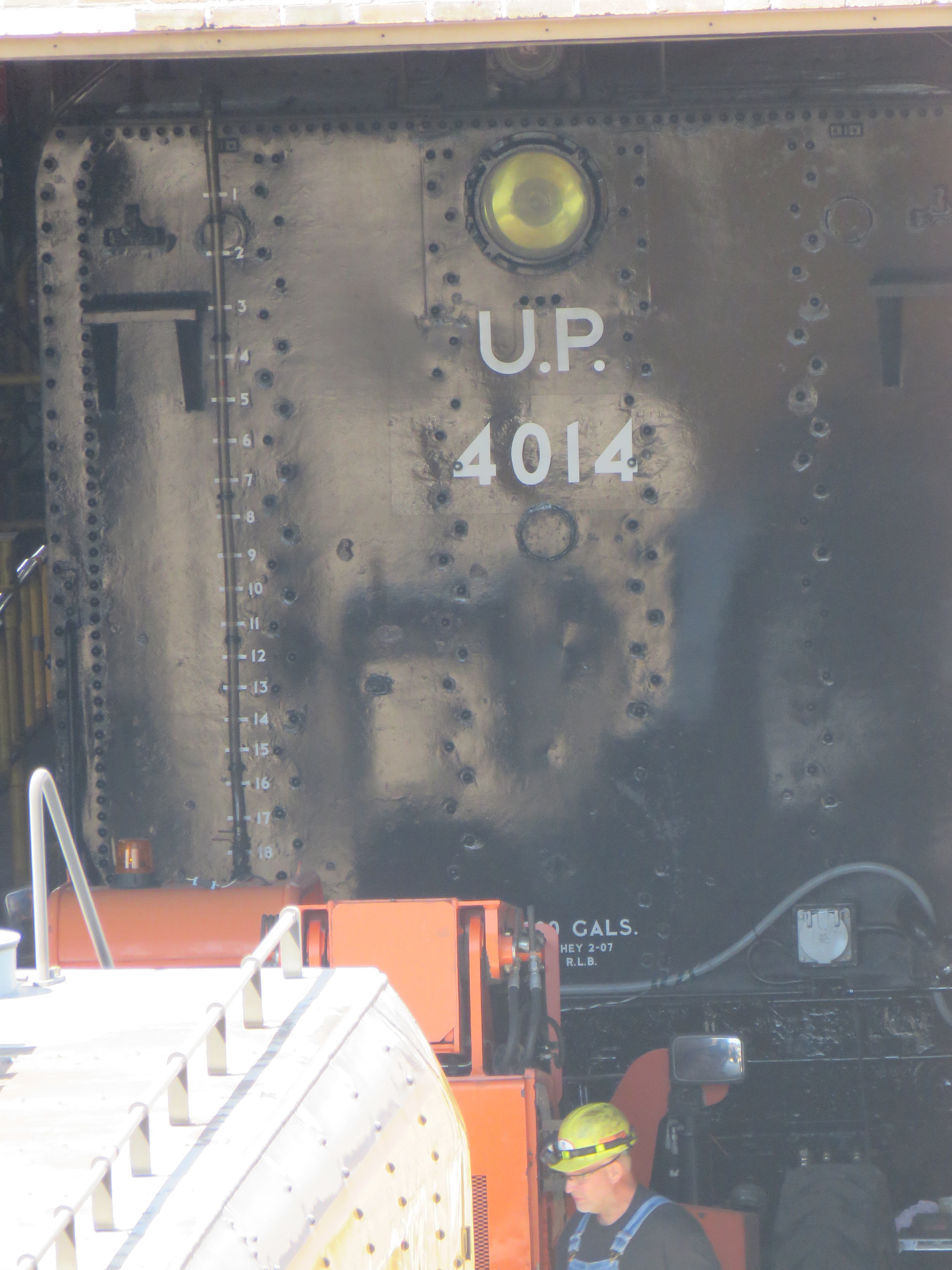
One of the holy sites to steam locomotives in the United States is the Union Pacific Steam Shop in Cheyenne, Wyoming. This is a building where Union Pacific’s legacy steam locomotives are stored and maintained (and in one case fully restored).
It’s most notable locomotive is the FEF-3 4-8-4 Northern locomotive #844 know to many fans across the world as the “Living Legend”. 844 is notable because it had never been retired since she was built in December of 1944. UP had keep 844 running as an ambassador for the company. As the 150th anniversary of the completion of the first Transcontinental Railroad neared, (where the Central Pacific and the Union Pacific met at Promontory Summit in Utah) Union Pacific had plans, big plans!
They chose the ambitious task of restoring to full operation one of the largest examples of a steam locomotive ever built, the 4-8-8-4 Wasatch type, known to rail fans as the Big Boy. 25 of these massive locomotives were built for the Union Pacific to tackle the the grades between Cheyenne, Wy and Ogden, Ut. There are eight Big Boys still in existence, all on static display, until now.
The steam crew looked at all of the existing Big Boys and decided that #4014, which was on display in the RailGiants Museum in Pomona, California, was the best candidate for restoration. 4014 had been retired in December of 1961 after logging 1,031,205 miles while in service.
The Big Boy was moved, by rail, from California to the Steam Shop in Cheyenne. From 2016 to 2019, 4014 was restored at the Steam Shop and had her first “maiden” run after six decades on May 4, 2019.
So here I stood on the walkway of Highway 180, which spans the tracks and yard in Cheyenne, looking down at the Steam Shop, hoping to get a glimpse of the recently restored monster. Three and a half bay doors were open. In one stood the Living Legend herself, 844!
What’s behind Door Number 3?
I later returned to find that the last bay door was fully opened, revealing the tender of Big Boy 4014! Well her backside will have to do.
Outside of the bay door where 4014 was stabled, there was an extra tender coupled to a UP EMD #4015. It looked like some crew members where making some adjustment to the tender. I didn’t know it at the time but this was a sign that 4014 was soon to be on the move. Two days later, 4014 and it diesel/electric helper an SD70M #4015 indeed were on the move as the crew took the Big Boy out on an unannounced test run from Cheyenne to Denver on July 8 and 9th. This was a test run for the month-long, multi-state tour that 4014 would begin on August 5.
It was hard to believe that I was so close to seeing 4014 in action but had no idea until after the fact, that the Big Boy was strutting out on the mainline. “Ugg!” As Charlie Brown would say.
The tender of 4014. The man in the foreground is 4014’s engineer and director of the Steam Program, Ed Dickens. This feels like a bit of a paparazzi shot. Oh, not for Ed but 4014!Cheyenne is a trainspotter’s paradise with 80 trains passing through every day like this eastbound freight.
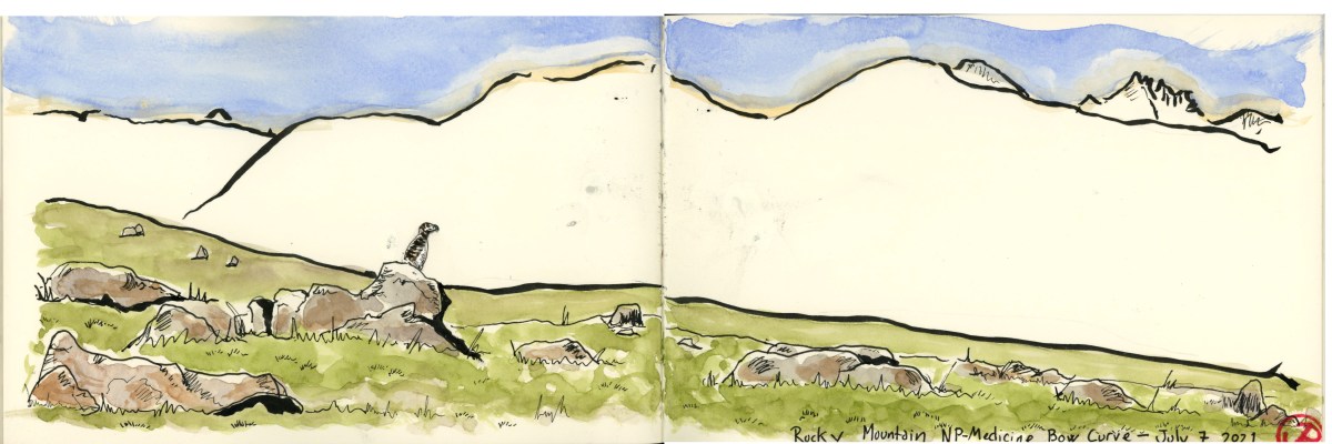
We had missed the all-white-bird-in-an-all-whire-landscape on April 5 and I was back in July at 11,600 feet to find the master of camouflage, the white-tailed ptarmigan.
This bird encounter in Rocky Mountain National Park in Colorado was to be one of my most memorable and perhaps my most personal.
We headed out on the Medicine Bow Bend trail under clear skies. The air was a bit thin for a sea leveler of the Coast Range like me but the air was not as thin as birding in the Andes at 13,000 feet looking for Andean condor.
We were in the Alpine Tundra of the high Rocky Mountains, above tree level where all flora had a stunted necessity because of the extreme conditions of high elevations coupled with a very short growing season.
We were ten minutes into our search along the trail when we heard the “ku-kurii” call somewhere upslope.
“Ptarmigan!” Carl said with joy mixed with relief.
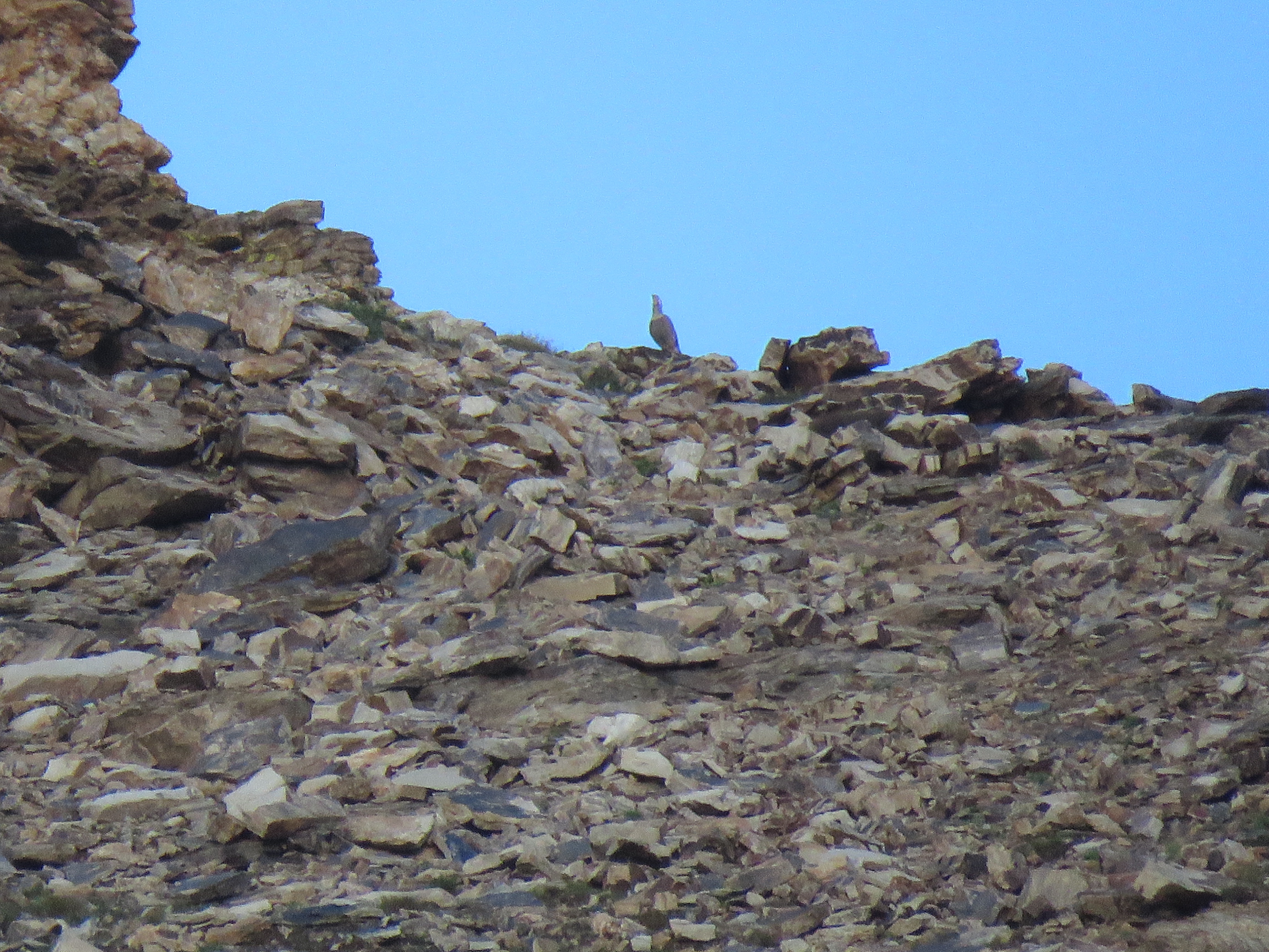
All eyes scanned the slope, where a ptarmigan can very much resemble a small rock in an environment strewn with small rocks!
Near the top of the ridge, Carl spotted a male ptarmigan, that looked very much like a rock. We trekked upslope to get a closer look. As it turns out, white-tailed ptarmigan are not so wary of humans, despite the fact that they are hunted as a game bird, but not here in Rocky Mountain N. P.
The ptarmigan flew downslope, revealing it’s all white wings. We all got eyes on it and then it promptly disappeared. Carl headed upslope in a round about manner but he couldn’t find the master of disguises. I scampered up to Carl’s position and scanned downslope only to find that Carl had walked right past him. The ptarmigan was sitting right next to a rock, looking very much like a rock.
This male ptarmigan was banded on both of it’s feathered feet that bore the number 47.
The male white-tailed ptarmigan (on the left) and a rock on the right.
I pulled out my sketchbook and we where close enough for me to get a quick sketch in.
We laid low and got amazing looks at the male, #47 by it’s leg bands. He was not focused on us, although we were very much focused on him, but his attention was drawn downslope. Soon the call of another male just down slope told us that we where at the border of a bird dispute where two territories come together.
A male from downslope flew up to where our bird was perched. What followed was a short flighted chase. The male ptarmigans land and both birds faced each other and boxed with their white wings. After the short conflict, the invading male turned tail, and flew back downslope to his territory.
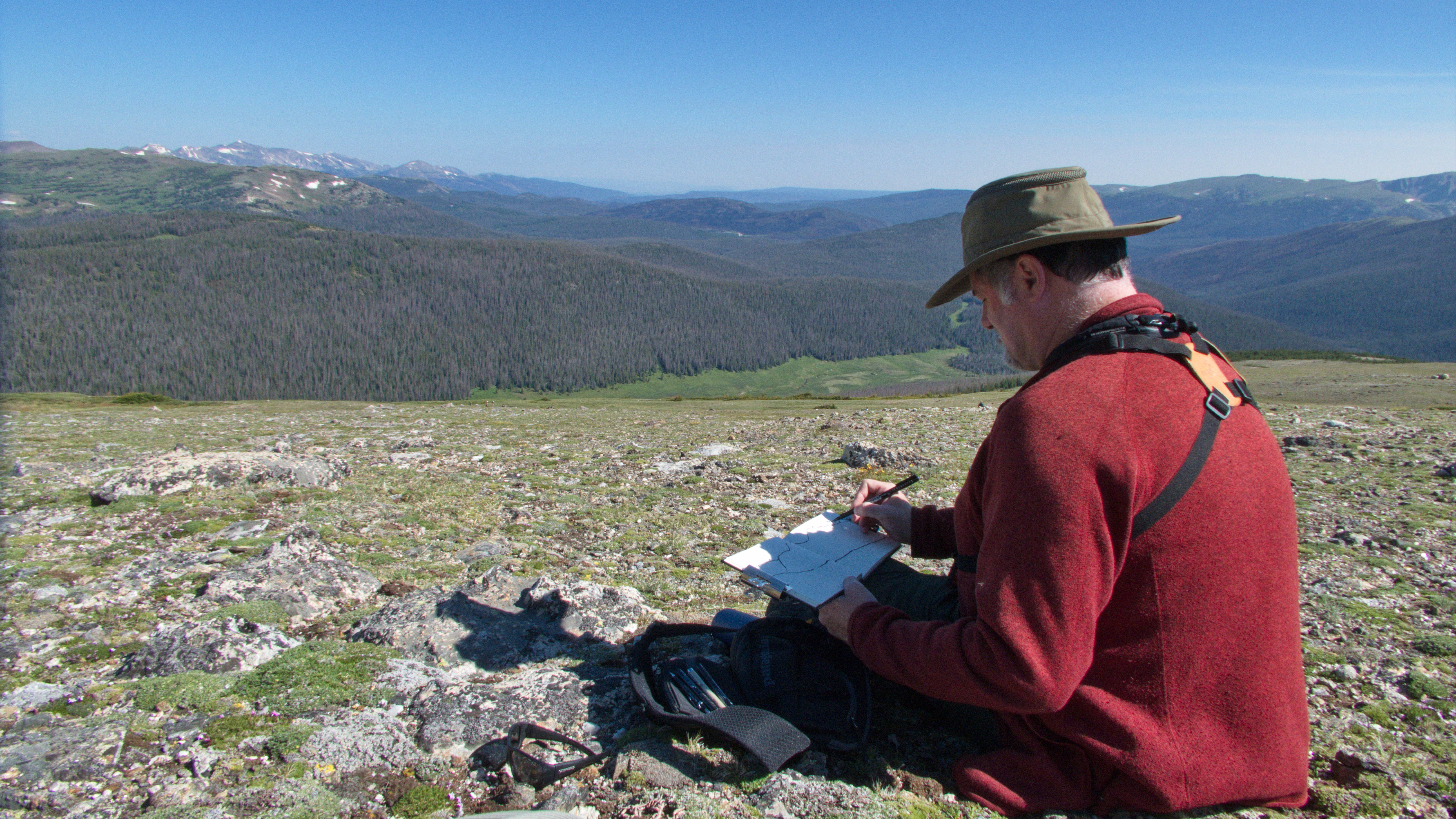
Here is a picture of Corvidsketcher sketching the featured sketch.A male is his territory. Note the feathered feet, represented in the genius of the species Lagopus (feathered feet) and he’s sporting jewelry, two leg bands that identifies this male as “47”.
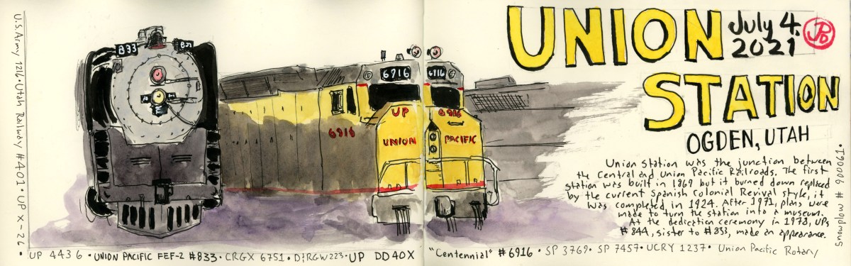
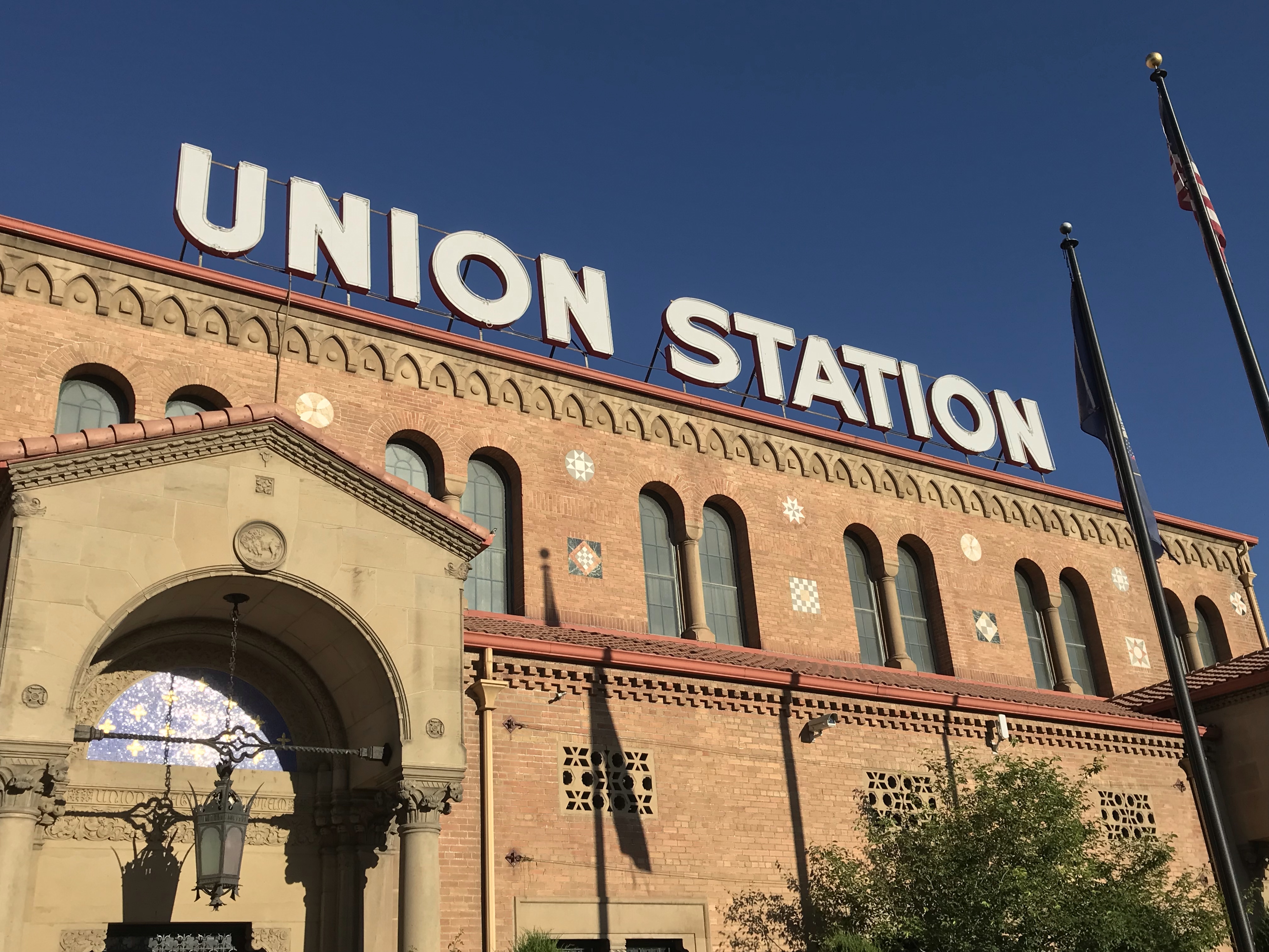
One of the places I wanted to visit on my Trails, Roads & Rails Roadtrip was Ogden’s Union Station. Ogden, Utah is at an important point where the Central Pacific (later to become the Southern Pacific) and the Union Pacific met. There are many other “Union” stations in the United States and it is an indicator that more that one railroad used the building as a passenger station. In Salt Lake City, for example, Union Pacific and the Rio Grande have separate stations (both are no longer used as station but the building still stand). Unfortunately, Ogden’s Union Station is no longer in service as a passenger station.
But the good news is that the building still stands and contains a cowboy, gun, art, and railroad museum. What they have outside is what really attracted me to Ogden: the locomotives and rails cars on static display! Because they were static and not going anywhere, anytime soon, made them great subjects for my sketch books.
When I arrived in Ogden on July 4, the museum was closed but this didn’t stop me from doing my first sketch of Union Pacific’s passenger locomotive, a 4-8-4 FEF-2 # 833 (a sister to the more well known #844) and UP DD40X “Centennial” #6916 (featured sketch). I set up my sketching chair in the shade provided by Union Station and sketched these two locomotives. #6916 is one of the “Centennial” class and is the largest and most powerful diesel/electric locomotive ever produced. UP always does everything a bit bigger to tackle the steep grades on it’s network, like the Wasatch Range from Ogden to Green River, Wyoming.
I have posted some of the other sketches from my time at Union Station. I returned on another day when the museums were open.
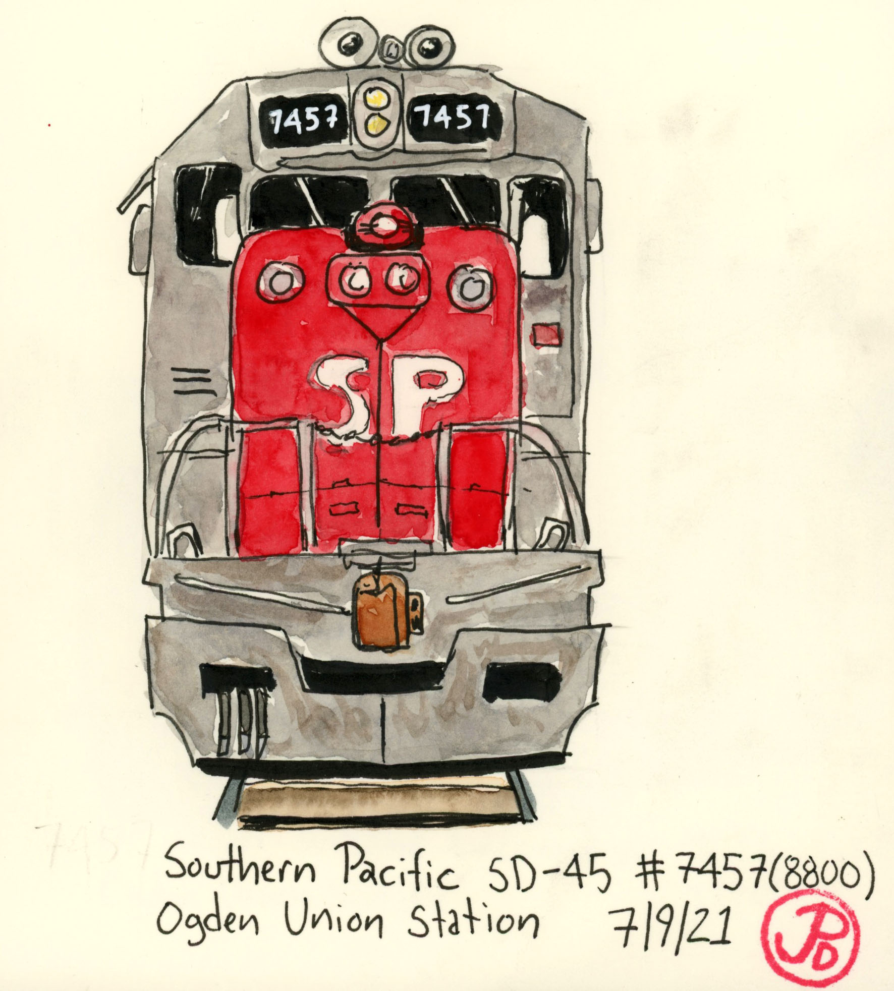
Above is a field sketch of the front of a Southern Pacific SD-45 #7457. Southern Pacific will always have a special place in my heart because this was the most likely livery to be seen where I grew up in the Bay Area. This paint scheme is known as the “Bloody Nose” livery because of it’s red front. #7457 worked from Ogden into California, pulling freight over the fabled Donner Pass.
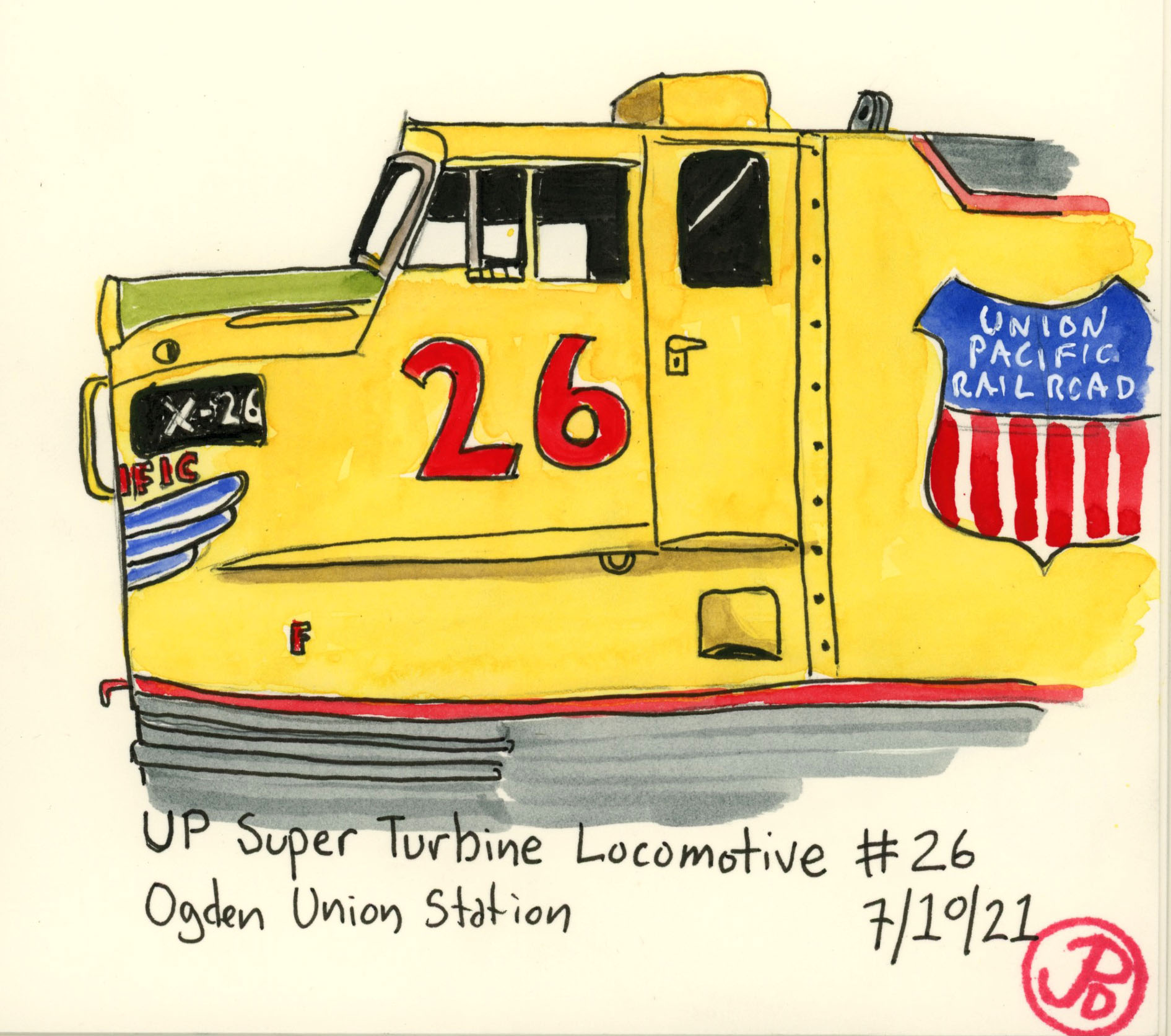
Keeping with Union Pacific’s mantra “bigger is better” I sketched the Super Gas Turbine locomotive #26. This locomotive is basically a jet engine on rails and is also known as the “Big Blow” for the loud noise it generated in operation. This was the class that was designed to replace the world’s largest steam locomotive, UP’s Big Boy. Union Pacific owned 55 of these locomotives, the only railroad in the country to own and operate these powerful beasts. Thirty locomotives (Numbers 1-30) where ordered from 1958 to 1961. These were the most powerful locomotives ever produced, generating 8,500 horsepower! That much horsepower also means an excessive amount of fuel to operate and they were last used in 1970. Number 26 is one of only two of these powerful locomotives to survive.
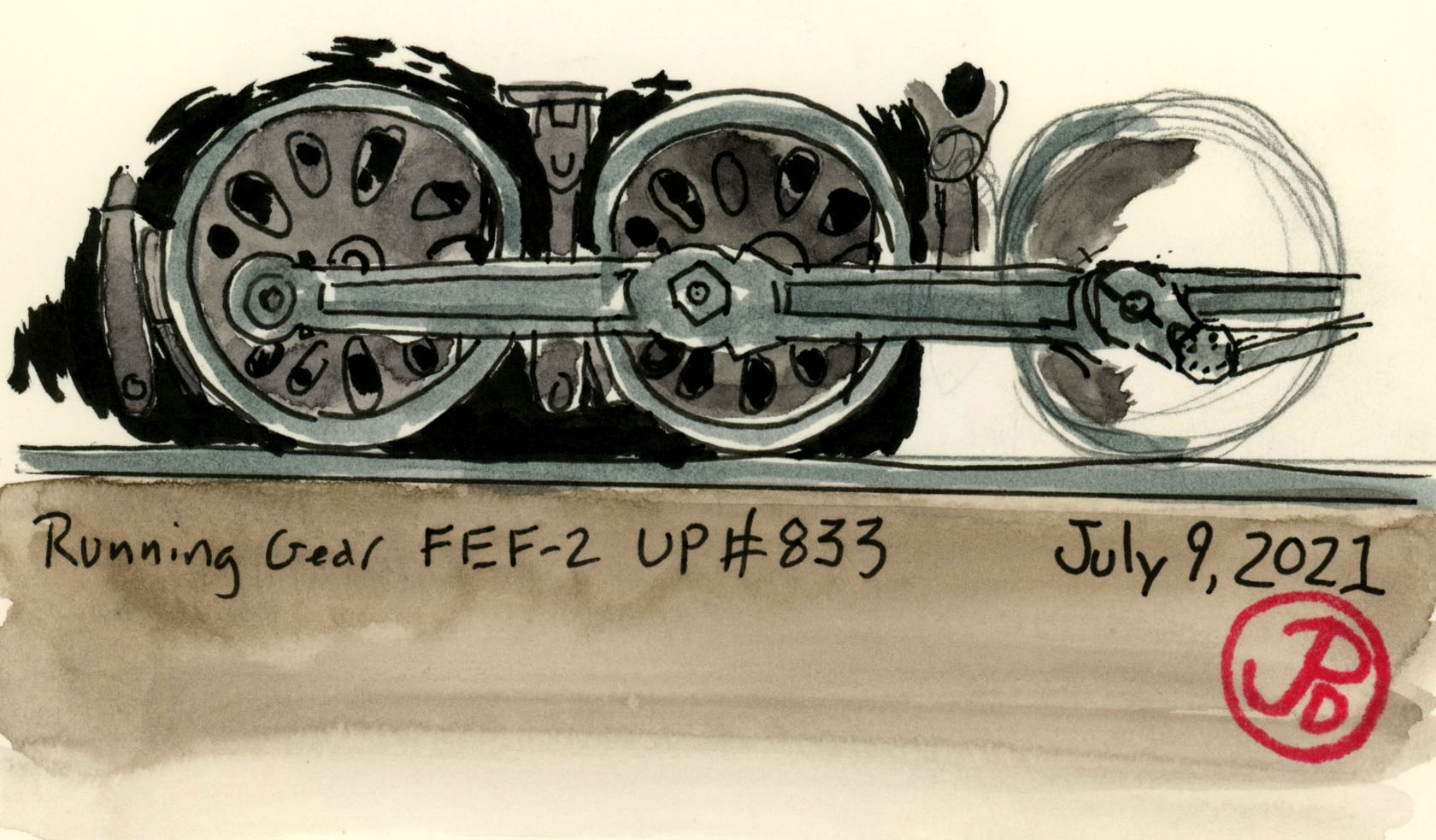
This field sketch is of the running gear of a class of successful passenger locomotives. Union Pacific FEF-2 #833 is the sister to the Living Legend, 844. 844 was the last steam locomotive purchased by Union Pacific and it is also notable as having never been retired from UP’s roster. Number 833 was put on display in a park in Salt Lake City and it was purchased by the Ogden Railroad Museum and it is the largest locomotive ever transported by truck.
On my journey from California to Colorado, I had a few historic sights I wanted to sketch along Highway 80 in Wyoming. This is Union Pacific territory, and the route over the Wasatch Mountains from Ogden Utah to Green River is legendary.
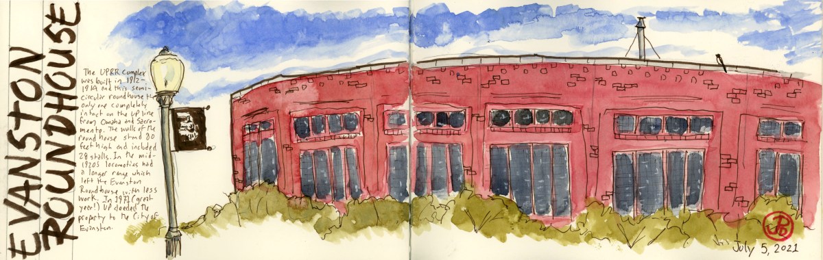
The Evanston Roundhouse and the Ames Monument are relics from a different time. The roundhouse was of a time when steam was the prime motive power of the Union Pacific and the monument the Ames brothers at Sherman Summit is no longer near the mainline (the line is now three miles to the south).
The Evanston Roundhouse is notable because it is the last completely intact roundhouse left on the Union Pacific line from Sacramento to Omaha. It had 28 stalls and is 80 feet high.
The roundhouse at Evanston on the left and the powerhouse on the right. The rusted, overgrown tracks in the foreground tells us that this complex has not been used by Union Pacific for a long time. I had to walk a ways back to photograph the whole massive roundhouse.
The roundhouse and yard was build by UP from 1912 to 1914. The roundhouse was part of a 27 acre complex to service steam locomotives. When steam locomotives became more efficient, they did not need to make so many service stops and the yard at Evanston was often bypassed. The Union Pacific deeded the property to the City of Evanston. The roundhouse is now used as a conference center and a meeting place.
Standing before the red brick semicircular roundhouse reminded me of a Plaza de Toros in Spain. Looking at just one part of the structure gives no indication of it’s form. I sketched one side of the roundhouse with the roofline slowing curving around (featured sketch). To see the entirety of the roundhouse, one has to walk back from the roundhouse by at least 100 yards to take it all in.
An intermodal freight passing through Evanston. The two locomotives on point represent the Transcontinental Railroad. The Union Pacific is pointed east towards Cheyenne and behind # 8990 is a former Southern Pacific locomotive (representing the Central Pacific) facing west toward Sacramento.
The next Union Pacific site is to be found off Highway 80 near the town of Buford (population 1). This is a monument to two brothers who were essential in creating the Union Pacific side of the Transcontinental Railroad.
The Ames Monument was built by the Union Pacific and dedicated to the brothers Oakes and Oliver Ames. It marked the highest point on the original Transcontinental Railroad at Sherman Summit at 8,247 feet. Oliver was one of the first presidents of the Union Pacific Railroad (from 1866-1871) and his brother Oakes was a U.S. Representative from Massachusetts. Both brothers, at the request of Lincoln, were put in charge of financing and building the Union Pacific portion of the railroad. Without the contribution of the Ames brothers, the railroad might never have been completed.
The 60 foot pyramid was build in 1880-1882 of granite at the cost of $64,000. On two side are base-relief portraits of each brother. In 1901, Union Pacific rerouted the mainline a few miles to the south.
On my first attempt to sketch the Ames Monument, a thunderstorm rolled in from the west. This monument being 60 feet high and at one of the highest points on the original Transcontinental Railroad, I though it would be wise to head to my car and return in the morning!
4:25 AM, Island Lake Trailhead, Ruby Mountains, Nevada.
Himalayan Snowcock. This introduced game bird is legendarily very hard to add to you ABA life list. Partly because it has an extremely small range in the Ruby Mountains in northeastern Nevada. It is also very skittish because, well, it’s a game bird after all. The snowcock, a native of southern Asia, was introduced in the Ruby Mountains in the 1963 and has a sustained breeding population.
To add this bird to your list you have to put in some sweat equity or have a ton of money (like the Steve Martin character in The Big Year, who hires a helicopter to see this bird!)
To see this bird with sweat and effort takes a two mile hike up the Island Lake Trail. From the trailhead to the lake is an elevation gain of about 1,000 feet and features many switchbacks.
The beginning of all things snowcock, the trail head for Island Lake. (This photo was taken on my return journey.)
What makes this trail perhaps a little bit more challenging is that most of the hike is done in darkness. The snowcock begins calling at about 5:45 AM and I planned to be in place by 5:30 to listen for and scan the ridges for snowcock. They seem to be harder to find later in the morning and in the afternoon.
And so I found myself, after a restless night of sleep, at the Island Lake Trailhead at 4:25 AM. On my forehead was the 400 Lumen Black Diamond Storm headlamp and on my back was an unwelding backpack with my scope, tripod, bins, camera, and sketchbook. In my hands where trekking poles to help with balance and pace and to fend off mountains lions or bears.
The headlamp provided a great pool of light to see the trail ahead. I turned my beam downslope and I picked up eyeshine. I boosted the power and was relieved to see that it was just a deer. Wait, where there is deer, there is mountain lion!!
About 15 minutes into my assent I came to the first switchback. Even in the glow of my headlamp I could see the trail was surrounded by wildflowers. I was looking forward to my return journey in morning light, hopefully with snowcock in the bag.
By the time I reached the wooden bridge across the falls, I was at the halfway point of the accent. At this point it was light enough to see and I stowed my headlamp. Here is where the switchbacks begin in earnest.
After a while I lost count of how many times the trail switched back on itself but I finally saw the ridge line in the half light and I knew I was near the end of the trail at Island Lake.
At the lake the trail forked and I headed to the right and soon the scrabble up to the northwest was to begin. This is where having trekking poles pays off. I headed up to one of the last group of trees, near a creek and I found a boulder seat to set up my scope and scan the ridges. It was now 5:30 AM.
A scope view from my position and the ridges that I would hopefully see this tough ABA lifer.
Now was the waiting time. Other reports had snowcocks calling from the ridge at 5:45. It was just a matter of time. But I also knew that snowcock is not always a given. Part of the unsigned agreement with the Birding Gods is that the more effort you put into seeing a bird does not guarantee seeing the bird.
At 5:55 AM I heard the far off bugle of a snowcock! The call in reminiscent of an elk bugle. I scanned the ridges with my scope to look for a bird silhouetted against the sky. At 6 AM I spotted the snowcock! I had the bird in view for about ten minutes and I was able get some far off photos to document the sighting.
A snowcock calling on the ridge!! All my effort had paid off!
The snowcock moved up slope and then dropped down on my side of the ridge where it disappeared amongst the rock. I pulled out my panoramic sketchbook and sketch the jagged ridge line of the Ruby Mountains and I drew in an arrow where I had first seen the Himalayan snowcock.
What a great experience with a much sought after ABA bird. Any lister wants this bird on their list and it is only found in one place in the United States. It was well worth the effort and the scenery and the return hike amongst the high elevation wildflowers was a nice coda.